Chapter 17.52A
GEOLOGIC SENSITIVE AREA REGULATIONS
Sections:
17.52A.010 Purpose of regulations.
17.52A.020 Designation of geologic sensitive areas.
17.52A.030 Mapping of geologic sensitive areas.
17.52A.050 Development in geologic sensitive areas.
17.52A.060 Modifications and flexibility.
17.52A.070 Vegetation management on steep slopes.
17.52A.080 Development standards.
17.52A.090 Repair of slope instabilities.
17.52A.100 Density calculation for critical slope areas.
17.52A.110 Seasonal restriction.
17.52A.010 Purpose of regulations.
A. The purpose of this chapter is to designate geologic sensitive areas in the city and to regulate development activities in or near geologic sensitive areas to safeguard the public health, safety and welfare.
B. Several geologic conditions influence development on or adjacent to slopes, including: slope inclination, soil types, underlying geology, groundwater and seepage, surface water runoff and vegetative cover. Therefore, for the purposes of this chapter, a geologic sensitive areas map has been prepared for the city that will be used to determine when additional site analysis will be required as a condition of development. This map is to be used as a trigger point for further site analysis and does not mean that properties that fall within a geologic sensitive area are unbuildable. Development within the city will be allowed, conditionally allowed, or prohibited, based on the city’s review of the findings of a geotechnical report of the site prepared by either an engineering geologist licensed in Washington State and/or a registered professional civil engineer licensed in the state of Washington (herein referred to as “licensed professional”) which addresses each of the items in this chapter.
C. Development within these geologic sensitive areas should be evaluated based on their impacts on the surrounding terrain and geological conditions, not in isolation. Management of the entire system should be considered during the development process. (Ord. 1124 § 9 (part), 2005)
17.52A.020 Designation of geologic sensitive areas.
Geologic sensitive areas include areas susceptible to erosion, sliding, earthquake, or other geological events and conditions. These pose a threat to the health and safety of citizens when improper and incompatible development is sited in these areas. Such incompatible development may not only place itself at risk, but also may cause or increase the hazards to surrounding development and land uses. Areas susceptible to one or more of the following types of hazards shall be designated as a geologic sensitive area:
A. Areas subject to erosion rated moderate to severe or higher by the U.S. Department of Agriculture’s Natural Resource Conservation Service;
B. Areas subject to erosion caused by streams, surface drainage, or along the shoreline;
C. Areas within a stream’s channel migration zone;
D. Areas mapped on the city of Mukilteo’s landslide hazard map having a moderate or higher rating;
E. Areas that are found to have, based on a site specific inspection, all of the following characteristics:
1. Springs or ground water seepage;
2. Hillsides showing intersecting geologic contacts; and
3. Slopes steeper than fifteen percent, fifteen-foot rise over one-hundred-foot run.
F. Areas that are underlain or covered by mass wastage debris or landslide materials;
G. Areas of known landslides, earth movement, or containing evidence of past landslides or earth movement;
H. Areas of steep slopes; slopes that have forty percent (forty percent or a twenty-two-degree angle) or steeper gradients and having a vertical relief greater than ten feet, excluding constructed slopes;
I. Areas subject to liquefaction due to soil type and/or location or seismically induced ground disturbance such as surface rupture, fissuring, and lateral spreading;
J. Areas that have soil types that fall within soil category II or III per the Preliminary Surficial Geologic Map of the Mukilteo and Everett Quadrangle, Snohomish County Washington, 1976; and/or
K. Areas that are subject to tsunami wave action.
|
Soil Category |
Soil Name (a) |
Soil Map Identification |
|---|---|---|
|
I |
Vashon Till |
Qvt |
|
II |
Double Bluff Drift |
Qdb |
|
II |
Vashon Recessional Outwash |
Qvr |
|
II |
Vashon Advance Outwash |
Qva |
|
II |
Whidbey Formation |
Qw |
|
II |
Artificial Fill |
Af |
|
II |
Modified Land |
ml |
|
III |
Beach Deposits |
Qb |
|
III |
Landslides |
Qls |
|
III |
Peat |
Qp |
|
III |
Old Landslides |
Qols |
|
III |
Esperance Sand |
Qe |
Soil map identification from Preliminary surficial geologic map of the Mukilteo and Everett Quadrangle, Snohomish County, Washington, 1976.
(Ord. 1124 § 9 (part), 2005)
17.52A.030 Mapping of geologic sensitive areas.
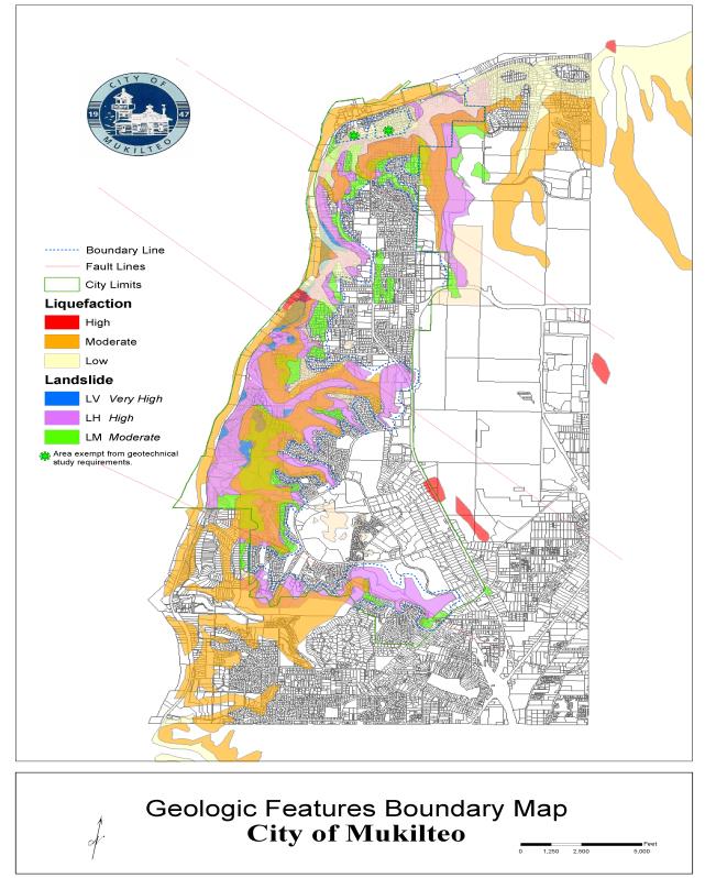
Utilizing the source documents listed, the city of Mukilteo has established geologic sensitive areas within its corporate limits. These areas are shown on Attachment A – Geologic Sensitive Areas Map, at the end of this chapter. All properties within or touching the limits shown on the map are considered to be on geologic sensitive land. This map is intended to be used as a guide for the city, project applicant and/or property owners and may be continuously updated as new sensitive areas are identified. The geologic sensitive areas map is also to be used as a reference and does not identify all or any final sensitive area designations.
A. City of Mukilteo Landslide Hazard Map;
B. City of Mukilteo Soil Identification Map;
C. U.S. Department of Agriculture’s Natural Resource Conservation Service Maps;
D. Coastal Zone Atlas (for marine bluff hazards);
E. U.S. Geological Survey Landslide Hazard, Seismic Hazard, and Volcano Hazards Maps;
F. Washington State Department of Natural Resources Seismic Hazard Maps for Western Washington;
G. Washington State Department of Natural Resources Slope Stability Maps;
H. National Oceanic and Atmospheric Administration Tsunami Hazard Maps; and
I. Federal Emergency Management Agency Flood Insurance Maps. (Ord. 1124 § 9 (part), 2005)
17.52A.040 Analysis required.
A. Full Geotechnical Analysis. All development proposals which include lands that are within the designated geologic sensitive area shall submit a geotechnical report and site assessment. The report and site assessment shall be provided at the applicant’s expense and shall contain the following information:
1. Site Plan and Analysis. Along with the standard site plan requirements, the following information shall be provided for the subject property:
a. Topography map at two-foot contour intervals prepared by a licensed land surveyor for the entire site including abutting public rights-of-way, private roads, or access easements.
b. Location of all significant trees shall be shown on the site plan and field-located by a licensed land surveyor. Significant trees include eight-inch conifers and twelve-inch deciduous trees measured at four feet above existing grade.
c. Drainage flow characteristics including pipes, drains, catch basins, drainage structures, culverts, underdrain pipes, and other structures shall be shown on the site plan prepared by a licensed land surveyor.
d. Location of all critical and sensitive areas as identified in Chapters 17.52 through 17.52E, including wetlands, streams, shorelands, and geologic sensitive areas.
e. Location of all existing site improvements and the amount of existing impervious surface area.
f. Location of all utilities: both above and below ground.
2. Geotechnical Report. The report, prepared by a licensed professional (either an engineering geologist or civil engineer specializing in geotechnical engineering) legally able to practice in the state of Washington, shall include an assessment of the geologic characteristics of the soils, sediments, and/or rock of the project area and potentially affected adjacent properties, and a review of the site history regarding landslides, erosion, and prior grading. Soils analysis shall be accomplished in accordance with accepted classification systems in use in the region. The assessment shall include, but not be limited to:
a. Data regarding underlying geology, slope gradients, soil types, and subsurface information including boring and/or test pit logs describing soil stratification, and results of soil tests conducted.
b. Identify any previous landslide activity in the vicinity of the project and provide an assessment of the overall slope stability and the effect the development will have on the slope and adjacent properties over time.
c. Recommendations for grading procedures, fill placement and compaction criteria, temporary and permanent slope inclinations and support, and design criteria for corrective measures and opinions and recommendations regarding the capabilities of the site.
d. The report shall consider seismic stability of the site in drained and saturated conditions. The geotechnical report shall include a statement that the design criteria consider a seismic event with a ten percent probability of being exceeded in fifty years.
e. Potential for liquefaction and proposed mitigation measures.
f. A description of the hydrology (both surface and subsurface) of the site, including locating any wetland, streams, springs, seeps, and groundwater along with recommendations consistent with the city’s critical area regulations (as contained in Chapters 17.52 through 17.52E) for addressing any impacts.
g. The report shall make a recommendation on building site location, foundation type and depths, minimum building setbacks, minimum deck and accessory building setbacks, and if necessary the minimum no-disturbance buffer, from any geologic sensitive area based upon the geotechnical analysis. The report shall also include recommendations on the design of temporary and permanent retaining structures if any are proposed.
h. An estimate of bluff retreat rate that recognizes and reflects potential catastrophic events such as seismic activity or one-hundred-year storm event.
i. Assessment of potential impacts created by a tsunami if applicable.
j. Recommendations and requirements for handling contaminated soils and materials if encountered on the site.
k. Third Party Review. A qualified licensed professional as defined in Chapter 17.08 shall prepare all reports and studies required of the applicant by this chapter. The city may retain a qualified licensed professional civil engineer that specializes in geotechnical engineering or an engineering geologist, licensed to practice in the state of Washington, at the expense of the applicant, to review and confirm the applicant’s reports, studies, and plans.
3. Grading and Erosion Control Plan. All development proposals within a geologic sensitive area shall submit grading, excavation, and erosion control plans approved and sealed by a licensed professional in accordance with Mukilteo Municipal Code Chapter 15.16, Grading and Excavation.
a. The grading plan shall: include a schedule showing when each stage of the project will be completed, and estimate starting and completion dates; the schedule shall be drawn up to limit to the shortest possible period the time that soil is exposed and unprotected;
b. Show measures to be taken for slope stabilization and erosion control using best management practices as contained in the Department of Ecology’s Storm Water Management Manual for the Puget Sound Basin, or other methodology as approved by the public works director.
4. Landscape/Revegetation Plan. A revegetation plan shall be prepared which uses the guidelines developed by the Department of Ecology in their publication “Vegetation Management: A Guide for Puget Sound Bluff Property Owners,” or other methodology as approved by the planning and public works directors. The revegetation plan shall include:
a. Measures to be taken for protection and replacement of the natural vegetative cover;
b. Vegetation trimming debris shall be removed from slopes in such a fashion as to not disturb existing vegetation; and
c. A schedule showing when each stage of the project will be revegetated with estimated starting and completion dates.
B. Geotechnical Letter Requirements. For the following single-family residential development applications, a letter prepared by a licensed professional may be prepared in lieu of the full geotechnical reporting requirements. A geotechnical letter summation shall include an assessment of the existing geological and geotechnical site conditions including surface water runoff, ground water, soil types, erosion, and slope stability. The licensed professional shall prepare conclusions and recommendations on the suitability of the proposed development and any mitigation necessary to address existing site conditions that may need to be modified due to the proposed development.
1. Additions to single-family residences two hundred square feet or less in size and more than twenty-five feet of the geologic sensitive area.
2. Additions to single-family residences greater than two hundred square feet in size but less than thirty percent of the size of the entire structure.
3. Second or third story additions where the footprint of the existing structure is not changed.
4. Earth retaining walls less than ten feet high that are at least fifty feet from a geologic sensitive area.
5. Land clearing, grubbing, and grading more than fifty feet from a geologic sensitive area.
6. Detached auxiliary buildings such as garages and sheds with no living spaces within fifty feet of a geologic sensitive area.
C. Exceptions. For the following single-family and multifamily residential development applications, the public works director may waive the requirements for a full geotechnical analysis or letter if the development has no impact on a geologic sensitive area:
1. Additions to single-family residences less than two hundred square feet in size where the addition is located in such a manner that the existing structure is located between the addition and the geologic sensitive area.
2. Detached auxiliary buildings such as garages and sheds that are fifty feet or more away from a geologic sensitive area.
3. Decks attached to single-family and multifamily residential structures where no additional load bearing weight is added to an adjacent geologic sensitive area.
D. Additional Review. The public works director may require a higher level of analysis than indicated in subsections B and C of this section if there is a localized condition on the site that cannot be adequately addressed in a letter report. (Ord. 1374 § 1, 2016; Ord. 1124 § 9 (part), 2005)
17.52A.050 Development in geologic sensitive areas.
A. Applicants proposing development on undeveloped lots within a geologic sensitive area shall comply with the building setback and buffer recommendation presented in the geotechnical analysis. In no case shall the critical slope setback be less than twenty-five feet from a steep slope (forty percent or twenty-two-degree angle) unless allowed through the “reasonable use” provisions of the Mukilteo Municipal Code and supported by a geotechnical report and approved by the public works director. Decks which add no substantial loading weight to the sensitive area and accessory buildings one hundred and twenty square feet or less may extend into the setback area to within ten feet of the top or toe of a steep slope.
B. New lots developed as part of a subdivision, short subdivision, binding site plans and those lots reconfigured as part of a boundary line adjustment, shall be created in such a manner so that:
1. There is sufficient area to construct all proposed structure(s), driveways, private roads, parking areas, drainage facilities, and yard areas while maintaining a twenty-five-foot building setback from a steep slope (forty percent slope or twenty-two-degree angle) or as recommended in the geotechnical analysis.
2. The lots must comply with the bulk requirements of the underlying zone in which it is located.
C. Utilities. Utility installation and repair projects within a geologic sensitive area shall comply with the reporting requirements contained in Section 17.52A.040, Analysis required. Geotechnical analysis letters may be allowed for projects less than two hundred feet in length. Exemptions may be allowed by the public works director for less than fifty feet. Utilities shall be designed according to the site specific geotechnical analysis and to meet typical public safety standards that include but are not limited to: use of polyethylene-encased ductile iron restraint joint pipes, isolation valves, pipe anchors, under drains, borings, uses of high density polyethylene pipe (HDPE), flexible expansion joints, minimized clearing, replanting of native vegetation, and installation of erosion control measures. (Ord. 1124 § 9 (part), 2005)
17.52A.060 Modifications and flexibility.
Alterations of the geologic sensitive areas or an associated setback may only occur where:
A. Modifications to slopes of forty percent or greater may only be allowed where the disturbed slope is not connected to a larger ravine system, is a manmade slope, or the area has been previously regraded and landscaped;
B. A site assessment has been submitted showing that the proposal will have no adverse impact on the stability or erosion susceptibility of the adjacent sensitive slope area;
C. The impacted area totals no more than twenty percent of the entire site;
D. The modification will not increase surface water discharge or sedimentation to adjacent properties beyond pre-development conditions;
E. The activity will not adversely impact other critical areas as regulated by Chapters 17.52 through 17.52E;
F. The development will not decrease slope stability on adjacent properties; and
G. Stormwater runoff from any new impervious surface shall be collected in a detention system and directed to an enclosed drainage system. Where minor additions of less than one thousand square feet of new impervious areas are proposed to existing developed properties that do not have detention facilities, the stormwater runoff shall be directed to the city’s storm drainage system or be designed for natural infiltration or dispersion. At no time shall concentrated stormwater runoff be allowed to flow directly over a steep slope or impact a neighboring property. (Ord. 1124 § 9 (part), 2005)
17.52A.070 Vegetation management on steep slopes.
Vegetation on steep slopes (slopes of forty percent and greater) shall be preserved over the entire steep slope area except as listed in subsections A through D of this section. Modifications from this section may be allowed as recommended in the Department of Ecology’s handbook “Vegetation Management: A Guide for Puget Sound Bluff Property Owners” and as approved by the city’s planning and public works directors.
A. Alder, willow and bitter cherry and other similar trees may be cut and removed from the site in a method determined by the planning director and public works director; however, the stumps and root systems shall be left undisturbed to protect the slope from erosion. Deep rooted bushes or ground cover such as ocean spray, snow berry, salal or evergreen huckleberry shall be planted around the stump of the tree to establish erosion control functions that the tree once provided.
B. Trees (such as big leaf maple, vine maple, Pacific madrone, red cedar and Douglas fir) which help to stabilize bluffs, offer wildlife habitat, and keep soils from being oversaturated with water may not be cut down, except with the submittal of a geotechnical report as approved by the public works director to maintain slope stability. However, the following tree trimming practices may be used in combination to provide some views without compromising tree health or slope stability. When using these tree trimming or pruning practices, a minimum of sixty percent of the original canopy/foliage must be retained to maintain the tree’s health (Figures 17.52A.070A and 17.52A.070B).
1. Windowing. Pruning major limbs that obscure a view, excluding the top third of the tree;
2. Interlimbing. Removal of an entire branch or individual branches throughout the canopy, excluding the top third of the tree, to allow more light to pass through as well as reducing wind resistance; and
3. Skirting-Up. Limbing the tree from the bottom upward to a maximum of twenty feet from the ground.
Figure 17.52A.070A
Alternative Pruning Practices – Conifers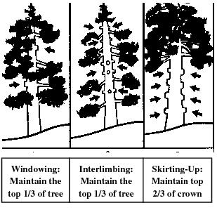
Figure 17.52A.070B
Alternative Pruning Practices – Deciduous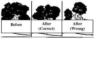
C. Himalayan blackberry, Scot’s broom, thistle and other similar invasive plants (including those listed by the Snohomish County noxious weed control board) may be removed manually from a steep slope with no or minimal soil disturbance, but the slope must immediately be replanted with native shrub species such as Oregon grape, salal and evergreen huckleberry.
D. Unless otherwise provided or as part of an approved alteration, removal of vegetation from erosion or landslide hazard or related buffer shall be prohibited. (Ord. 1308 § 2, 2012; Ord. 1124 § 9 (part), 2005)
17.52A.080 Development standards.
Development within a geologic hazard area and/or buffer shall be designed to meet the following basic requirements unless it can be demonstrated that an alternative design that deviates from one or more of these standards provides greater long-term slope stability while meeting all other provisions of this title. The requirement for long-term slope stability shall exclude designs that require regular and periodic maintenance to maintain their level of function. The basic development design standards are:
A. The proposed development shall provide a safety factor of 1.5 for static conditions and 1.2 for dynamic conditions for seismic occurrences. Analysis of dynamic conditions shall be based on a minimum horizontal acceleration as established by the current adopted version of the International Building Code;
B. Structures and improvements shall be clustered to avoid geologic sensitive areas and other critical areas;
C. Structures and improvements shall minimize alterations to the natural contour of the slope and foundations shall be tiered to conform to existing topography;
D. Structures and improvements shall be located to preserve the most sensitive portion of the site and its natural landforms and vegetation;
E. The proposed development shall not result in greater risk or a need for increased buffers on neighboring properties;
F. Single-family residential development shall be designed so that the impervious lot coverage does not exceed fifty percent of the site; and
G. Stormwater runoff shall be collected, detained, and released in accordance with the city’s stormwater detention requirements. At no time shall concentrated stormwater runoff be allowed to flow directly over a steep slope or impact a neighboring property. (Ord. 1124 § 9 (part), 2005)
17.52A.090 Repair of slope instabilities.
Repair of slope instabilities and slope failures on an emergency basis shall be allowed by the planning and public works directors as needed to correct an immediate danger to the public health, welfare and safety. The directors shall use the guidance of this chapter when evaluating the necessary repairs and add mitigation measures as appropriate to ensure that the intent of this chapter has been met. (Ord. 1124 § 9 (part), 2005)
17.52A.100 Density calculation for critical slope areas.
A. An owner of a site or property containing a geologic hazard area may be permitted to transfer the density attributable to the geologic hazard area portion of the property to another nonsensitive portion of the same site or property subject to the limitation of this section.
B. Up to one hundred percent of the density that could be achieved on the geologic sensitive area portion of the site can be transferred to the non-sensitive portion of the property, subject to:
1. The density limitation of the underlying zoning classification;
2. The minimum lot size of the underlying zoning classification may be reduced to three thousand square feet in order to accommodate the transfers in densities;
3. Applicable setbacks may be reduced to fifteen feet, and the lot coverage standards of underlying zoning regulations may be increased to sixty percent;
4. Provided that the area to which the density is transferred shall not be constrained by another environmentally critical area regulation. (Ord. 1124 § 9 (part), 2005)
17.52A.110 Seasonal restriction.
Clearing and grading within the wet weather months (October to April) shall only be allowed with the approval of the public works director and the developer shall fully implement a winter weather construction plan using at a minimum the current best management practices as outlined in Section 15.16.160, Erosion control. Failure to implement the winter weather construction plan and/or turbid water leaves the site, construction shall be stopped immediately until proper erosion control devices are implemented and established. (Ord. 1124 § 9 (part), 2005)
Attachment A – Geologic Sensitive Areas Map