


Chapter 17.115
SUBDIVISIONS
Sections:
17.115.060 Scope of application.
17.115.070 Enforcement and permits.
17.115.080 Subdivision land use authority.
17.115.090 Subdivision appeals.
17.115.100 Subdivision applications.
17.115.110 Acceptance of dedicated streets and public improvements.
17.115.120 General improvement requirements.
17.115.130 Improvement completion assurance.
17.115.140 Orderly development required.
17.115.150 Design standards, area and access requirements.
17.115.160 Subdivision improvements.
17.115.200 Lot line adjustments.
17.115.210 Amending a subdivision.
Prior legislation: Ords. 82-6, 11-127, 11-132, 12-142, 12-149, 13-151 and 13-157.
17.115.010 General purpose.
The purpose of this chapter is:
(1) To promote health, safety, and general welfare of the residents of Naples City.
(2) To promote the efficient and orderly growth of the city.
(3) To provide standards for the physical development of subdivisions of land, construction of buildings and improvements within this city including, but not limited to, the construction and installation of roads, streets, curbs, gutters, drainage systems, water and sewer systems, design standards for public facilities and utilities, accesses to public rights-of-way, dedication of land and streets, granting easements or rights-of-way and to establish fees and other charges for the authorizing of a subdivision. [Ord. 24-258, 2024; Ord. 18-215, 2018; Ord. 17-197 § 1, 2017. LUO § 02-31-001.]
17.115.020 Definitions.
See Chapter 17.10 NCC, Definitions.
The following words and phrases, as used throughout city ordinances, shall have the following meanings. Words and phrases not defined in this section or elsewhere in city ordinances (see Chapter 17.10 NCC) shall have the meaning defined in state law. Words and phrases not defined in city ordinances or state law shall have their plain meaning in common usage. As used herein, the following words and phrases shall mean:
“Affected entities” means a county; a municipality; a local district; a special service district under the Utah Special Service District Act; a school district; an interlocal cooperation entity established under the Interlocal Cooperation Act; an electrical, gas, or telephone utility as defined in Section 54-2-1, Utah Code Annotated 1953 (as amended); a property owner; a property owners’ association; or the Utah Department of Transportation (UDOT), if:
(a) The entity’s services or facilities are likely to require expansion or significant modification because of an intended use of land;
(b) The entity has filed with the city a copy of the entity’s general or long-range plan; or
(c) The entity has filed with the city a request for notice during the same calendar year and before the city provides required notice to an affected entity.
“Alley” means a public thoroughfare at least 26 feet wide.
“Appeal authority” means the person or persons designated by ordinance enacted by the city to hear land use appeals.
“Applicant” means a person who submits a land use application.
“Association” means the same as that term is defined in Section 57-8a-102, Utah Code Annotated 1953, as amended.
“Block” means a piece of land which is designated or shown as a block on any recorded subdivision plat or official map or plat adopted by the city council.
“City” means Naples City, Utah.
“Common areas” means property that an association owns, maintains, repairs, or administers.
“Condominium” means a multi-unit development in which individual units are separately owned and each owner receives a recordable deed to the unit, together with an undivided interest in any common elements. A condominium development shall be regarded as a subdivision.
“Council” means the city council; the governing/legislative body of Naples City.
“Construction standards” menans the standards and specifications adopted by this chapter.
“Cul-de-sac” means a turnaround on a dead-end street.
Developer. See “Applicant.”
“Development” means on land, in or under land or water, the placement or erection of any solid material or structure; construction, reconstruction, demolition, or alteration of the size of any structure, including any facility of any private, public, or municipal utility, trail, or road.
“Easement” means an interest in land owned by another person, consisting in the right to use or control the land, or an area above or below it, for a specific limited purpose (such as to cross it for access to a public road).
“Engineer (city)” means the licensed engineer appointed by the city to be the city engineer, or the engineer appointed for a specific project.
“Facility owner” means, in the context of water conveyance, an individual, entity, mutual water company, or unincorporated organization:
(a) Operating a water conveyance facility;
(b) Owning any interest in a water conveyance facility; or
(c) Having a property interest in real property based on the presence of the water conveyance facility located and operating on the real property.
“Fire authority” means the department, agency, or public entity with responsibility to review and approve the feasibility of fire protection and suppression services for the subject property.
“Half streets” means the portion of a street within a subdivision comprising one-half the minimum required right-of-way on which improvements are constructed and in accord with one-half of an approved typical street cross-section.
“Improved lot” means a lot which has all of the improvements required by this chapter completed.
“Improvement plan” means a plan, complete with civil engineering plans, to complete permanent infrastructure on the subdivision that is essential for the public health and safety, that is required for human occupation, or that is required by applicable law in connection with a subdivision application, and that an applicant must install in accordance with public installation and inspection specifications for public improvements and as a condition of recording a subdivision plat.
“Improvement (required)” means work, objects, devices, facilities, or utilities required to be constructed or installed in a subdivision. Such improvements shall include, but are not limited to, street construction to required standards, grading, landscaping, water facilities, sewer facilities, streets, trees, sidewalks, curbs and gutters, drainage facilities, street signs, street lights, traffic control or other safety devices, fire hydrants, utilities and such other facilities, or construction required by the subdivision ordinance, subdivision regulations, or by the land use authority for the necessary proper development of the proposed subdivision.
“Improvement warranty” (or “warranty”) means, in the context of completed improvements, an applicant’s unconditional warranty that the applicant’s installed and accepted landscaping or infrastructure improvement complies with the city’s written standards for design, materials, and workmanship, and will not fail in any material respect, as a result of poor workmanship or materials, within the improvement warranty period.
“Intervening property” means property located between the existing service facility and the property under development.
“Land use application” means an application required by the city and submitted by a land use applicant to obtain a land use approval; this does not mean an application to enact, amend, or repeal a land use regulation.
“Land use authority” means an individual, board, or commission appointed or employed by the city to make land use decisions. “Land use authority” includes any appropriately authorized designees.
“Land use ordinance” means the land use ordinance of Naples City.
“Lot” means a parcel or tract of land which is or may be legally occupied by a building(s).
“Lot line adjustment” means the process of combining two or more lawful existing lots into a fewer number of total lots than existed prior to the boundary line adjustment; or the moving of a boundary line between two or more lots where the total number of lots after the change remains the same.
“Lot right-of-way” means an easement of at least eight feet width, reserved by the lot owner as a private access to serve interior lots not otherwise located on a street.
“Master plan” means the master plan of this City.
“Master street plan” means the master street plan of this city.
“Metes and bounds” means the description of a lot or parcel of land by courses and distance.
“Minor subdivision” means a subdivision containing four lots or less with all lots having the required frontage on a dedicated public street and not traversed by a proposed street.
“Official map” means the official map or maps adopted by this city pursuant to the municipal land use and planning enabling legislation.
“Off-site facilities” means facilities designed or located so as to serve other property outside of the boundaries of the subdivision, usually lying between the development and existing facilities.
“On-site facilities” means facilities installed within or on the perimeter of the subdivision.
“Oversized facilities” means facilities with added capacity designed to serve other property, in addition to the land within the boundaries of the subdivision.
“Parcel of land” means a contiguous area of land with a separate or discrete legal description.
“Period of administrative control” means the period of control described in Section 57-8-16.5(1), Utah Code Annotated 1953, as amended.
“Permanent monument” means any structure of concrete, masonry, and/or metal, permanently placed on, or in, the ground, including those expressly placed for surveying reference.
“Person” means an individual, individuals, tenants in common, joint tenants, a corporation, partnership, firm, limited partnership or association of individuals however styled or designated.
“Planning commission” means the planning commission of Naples City.
“Plat” means an instrument subdividing property into lots as depicted on a map or other graphic representation of land that a licensed professional land surveyor makes and prepares in accordance with Section 10-9a-603 or 57-8-13, Utah Code Annotated 1953, as amended.
“Protection strip” means a strip of land, of less than the minimum depth required by the land use ordinance for a building lot, which prevents the access of other property owners to the street or utilities.
“Public landscaping improvement” means landscaping that an applicant is required to install to comply with published installation and inspection specifications for public improvements that:
(a) Will be dedicated to and maintained by the city; or
(b) Are associated with and proximate to trail improvements that connect to planned or existing public infrastructure.
“Review cycle,” as used and further defined in NCC 17.115.100(3), means the occurrence of:
(a) The applicant’s submittal of a complete subdivision land use application;
(b) The city’s review of that subdivision land use application;
(c) The city’s response to that subdivision land use application, in accordance with this section; and
(d) The applicant’s reply to the city’s response that addresses each of the city’s required modifications or requests for additional information.
“State engineer’s inventory of canals” means the state engineer’s inventory of water conveyance systems established in Section 73-5-7, Utah Code Annotated 1953.
“Street” means a thoroughfare which has been dedicated and accepted by the city council, which the city has acquired by prescriptive right or which the city owns, or offered for dedication on an approved plat, or a thoroughfare of at least 32 feet in width, which has been abandoned or made public by right of use and which affords access to abutting property, including highways, roads, lanes, avenues, alleys, and boulevards.
“Street, collector” means a street, existing or proposed, which is the main means of access to the major street system. Collector streets are at least 66 feet wide.
“Street, major” means a street, existing or proposed, which serves or is intended to serve as a major traffic way and is designated on the master street plan as a controlled access highway, major street, parkway, collector, arterial or other equivalent term to identify those streets comprising the basic structure of the street plan. Major streets are at least 72 feet wide.
“Street, marginal access” means a minor street which is parallel to and adjacent to a limited access major street and which provides access to abutting properties and protection from through traffic.
“Street, minor” means a street, existing or proposed, which is supplementary to a collector street, and of limited continuity, which serves, or is intended to serve, the local needs of a neighborhood. Minor streets are at least 60 feet wide.
“Street, private” means a thoroughfare within a subdivision which has been reserved by dedication of the applicant or lot owners to be used as private access to serve the lots platted within the subdivision and complying with the adopted street cross-section standards of this city and maintained by the applicant or other private agency.
“Subdivider” means the person submitting a subdivision application to subdivide land under this chapter.
“Subdivision” means any land that is divided, subdivided, or proposed to be divided into two or more lots or other division of land for the purpose, whether immediate or future, for offer, sale, lease, or development either on the installment plan or upon any and all other plans, terms, and conditions.
(a) Subdivision includes:
(i) The division or development of land, whether by deed, metes and bounds description, devise and testacy, map, plat, or other recorded instrument, regardless of whether the division includes all or a portion of a parcel or lot; and
(ii) Except as provided below, divisions of land for residential and nonresidential uses, including land used or to be used for commercial, agricultural, and industrial purposes.
(b) Subdivision does not include:
(i) A bona fide division or partition of agricultural land for the purpose of joining one of the resulting separate parcels to a contiguous parcel of unsubdivided agricultural land, if neither the resulting combined parcel nor the parcel remaining from the division or partition violates an applicable land use ordinance;
(ii) A boundary line agreement recorded with the office of the county recorder between owners of adjoining parcels adjusting the mutual boundary in accordance with Section 10-9a-524 Utah State Code Annotated 1953 (as amended) if no new parcel is created;
(iii) A recorded document, executed by the owner of record revising the legal descriptions of multiple parcels into one legal description encompassing all such parcels or joining a lot to a parcel;
(iv) A joining of one or more lots to a parcel;
(v) A road, street, or highway dedication plat; or
(vi) A deed of easement for a road, street, or highway purpose.
“Subdivision ordinance review” means review by the city to verify that a subdivision application meets the criteria of the city’s ordinances.
“Subdivision plan review” means a review of the applicant’s subdivision improvement plans and other aspects of the subdivision application to verify that the application complies with municipal ordinances and applicable installation standards and inspection specifications for infrastructure improvements.
Subdivision Review Committee. A committee that consists of the land use administrator, city engineer, building inspector, a member of the planning commission, and other selected city staff shall serve as members of the SRC.
“Underground facility” means infrastructure or equipment that is buried or placed below ground level for use in the storage or conveyance of any of the following:
(a) Water;
(b) Sewage, including sewer laterals;
(c) Communications, including electronic, photonic, telephonic, or telegraphic communications;
(d) Television, cable television, or other telecommunication signals, including transmission to subscribers of video or other programming;
(e) Electric power;
(f) Oil, gas, or other fluid and gaseous substances;
(g) Steam;
(h) Slurry; or
(i) Dangerous materials or products.
“Utilities” includes culinary water lines, pressure and gravity irrigation lines, ditches, sanitary and storm sewer lines, electric power, gas and telephone transmission lines, cable and data transmission lines, underground conduits, and junction boxes.
“Variance” means an authorization by the planning commission, acting as the land use authority pursuant to state law, relative to a specific parcel of land for a modification of a zone’s standard height, bulk, area, width, setback, or separation requirement; as distinguished from a conditional use, the allowing of a use not listed as permitted in a zone, or any other change in zoning requirements.
“Vicinity plan” means a map or chart showing the relationship of streets within a proposed subdivision to streets in the surrounding area.
“Water conveyance facility” means a ditch, canal, flume, pipeline, or other watercourse used to convey water used for irrigation or storm water drainage and any related easement for the ditch, canal, flume, pipeline or other watercourse. “Water conveyance facility” does not mean a ditch, canal, flume, pipeline, or other watercourse used to convey water used for culinary or industrial water, or any federal water project facility. [Ord. 24-258, 2024; Ord. 18-215, 2018; Ord. 17-197 § 1, 2017. LUO § 02-31-002.]
17.115.030 Prohibited acts.
(1) Improved Lots Required. All buildings shall only be built on improved lots, except buildings which are bona fide agricultural buildings as to which there is no human occupancy.
(2) Subdividing Land. It shall be unlawful for any person to subdivide for the purpose of transferring, selling, conveying or assigning any tract or parcel of land which is located wholly or in part in the city, except in compliance with this chapter.
(3) Subdivisions. It shall be unlawful for any person to sell or exchange or offer to sell or exchange any parcel of land which has been subdivided unless the subdivision has been approved by Naples City and meets the provisions of this chapter and Utah state code. A subdivision is not valid unless its governing document is approved by the land use authority and properly recorded in the county recorder’s office. [Ord. 24-258, 2024; Ord. 18-215, 2018. LUO § 02-31-003.]
17.115.040 Penalty.
Any persons, firm, or corporation, who shall subdivide land or who shall transfer or sell any lot or land in a subdivision, as defined in this code, which subdivision has not been approved by the land use authority, shall be guilty of a Class B misdemeanor for each lot or parcel of land so subdivided, transferred or sold, and the description of such lot or parcel of land by metes and bounds in the instrument of transfer, or other document used in the process of selling or transferring, shall not exempt the transaction from such penalties, or from the remedies herein provided. The city may enjoin such transfer or sale or agreement by action for injunction brought in any court of competent jurisdiction, or may recover a civil penalty by civil action in any court of competent jurisdiction, together with costs and attorney fees incurred in enforcing this chapter. [Ord. 24-258, 2024; Ord. 18-215, 2018. LUO § 02-31-004.]
17.115.050 Validity.
If any section, subsection, sentence, clause, or phrase of this chapter, for any reason, is held to be invalid, such holding shall not affect the validity of the remaining portion of this chapter. [Ord. 24-258, 2024; Ord. 18-215, 2018. LUO § 02-31-005.]
17.115.060 Scope of application.
All lots, plots or tracts of land located within Naples City shall be subject to this chapter whether the tract is owned by an applicant or a subsequent purchaser, transferor or holder of the land. [Ord. 24-258, 2024; Ord. 18-215, 2018. LUO § 02-31-006.]
17.115.070 Enforcement and permits.
(1) Land Use Administrator and Building Official to Enforce. The land use administrator and the building official are hereby designated and authorized as the officers charged with the enforcement of this chapter.
(2) Permits. The building official shall not grant a permit nor shall any officer grant any license or permit for the use of any land or the construction or alteration of any building or structure on a lot which would be in violation of any Utah state law, rule or regulation or ordinance of Naples City until a subdivision/development plat has been approved and recorded pursuant to this chapter, and all other requirements are met. Any license or permit issued in conflict with such provisions shall be null and void. It shall be the responsibility of the applicant to show that the lot has been lawfully created.
(3) Inspections. The building official, or designee, shall inspect or cause to be inspected all roads, buildings, fire hydrants and water supply, and sewage disposal systems or other infrastructure in the course of construction, installation or repair. The applicant shall notify the building department of any work to be done, and the building official, or designee, shall inspect the work within two business days of said notification. Excavations and installed systems for fire hydrants, water and sewer mains and laterals, shall have been approved by the engineer or the land use administrator. If any such installation is covered before being inspected and approved, it shall be uncovered at the expense of the applicant after notice to uncover has been issued to the responsible person by the inspector. [Ord. 24-258, 2024; Ord. 18-215, 2018. LUO § 02-31-007.]
17.115.080 Subdivision land use authority.
(1) The land use authority for subdivision applications, except where otherwise noted, is the subdivision review committee (“SRC”). The land use administrator, city engineer, building inspector, a member of the planning commission, and other selected city staff shall serve as members of the SRC. The SRC shall meet on an as-needed basis and shall act through majority vote. The SRC may delegate tasks as desired to the land use administrator or other city staff.
(2) The SRC is responsible for the following:
(a) Rendering a land use decision on all subdivision applications and petitions under this chapter.
(b) Reviewing all applications under this chapter in an impartial manner and according to the standards and deadlines described in this chapter.
(c) Providing feedback to applicants in the manner required by this chapter.
(d) Scheduling and holding a pre-application meeting with potential applications if they so choose as required in this chapter.
(e) Holding a public hearing when required by this chapter.
(f) Keeping subdivision application forms and related information material up to date and publicly accessible and distributing such forms and materials to potential applicants.
(g) Providing notice to entities and parties as required in this chapter.
(h) Signing application and petition approvals as required in this chapter.
(i) Ensuring that documents are properly recorded by the applicant with the county as required in this chapter.
(3) The planning commission may provide comments and suggestions to the SRC on pending subdivision applications. However, the SRC retains the authority to issue binding decisions on subdivision applications under this chapter.
(4) As subdivision application decisions are administrative, not legislative, decisions, the land use authority is authorized to review and approve or deny subdivision applications without city council approval.
(5) Except when operating as the appeal authority, the city council shall not require the land use authority to approve or deny a subdivision application. [Ord. 24-258, 2024. LUO § 02-31-008.]
17.115.090 Subdivision appeals.
(1) The appeal authority for city decisions related to this chapter, except when otherwise noted, is the city council.
(2) The appeal authority shall hear appeals on final decisions made by the land use authorities and shall hear complaints about the conduct of the land use authorities in administering the provisions of this chapter.
(3) A party appealing or complaining of a land use authority’s decision under this chapter must exhaust its remedies under this section (by appealing or complaining to the appeal authority) before bringing an action against the city in a court of law.
(4) A party who has submitted a subdivision application or petition may appeal or complain to the appeal authority under this chapter. In such an appeal or complaint, the party may appeal or complain only regarding the land use authority’s treatment of that party’s own application; a third party may not appeal or complain of the land use authority’s decisions or conduct.
(5) A party desiring to appeal or complain of a land use authority decision shall submit to the appeal authority the following in writing:
(a) A brief explanation of the relief the party is seeking, the reason the party submitted its application or petition, the land use authority’s decision and treatment of the application or petition, and why the applicant believes the land use authority misapplied the provisions of this chapter or abused the discretion given it by this chapter.
(b) The most recent version of the application or petition the party submitted.
(c) Any supplemental documentation or information that the appeal authority requests.
(6) All appeals and complaints must be emailed or mailed to the city recorder using the recorder’s official city address and/or email account listed on the city website.
(7) After receiving a complete appeal or complaint in accordance with this section, the appeal authority shall confer and deliver a decision to the applicant, in writing, no later than 30 calendar days after the appeal authority receives the appeal or complaint. [Ord. 24-258, 2024. LUO § 02-31-009.]
17.115.100 Subdivision applications.
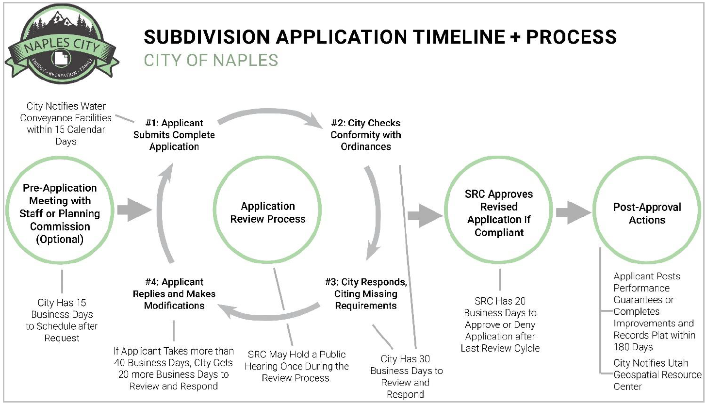
Prior to subdividing/developing any tract of land, the applicant shall comply with the requirements of this chapter.
(1) Pre-Application Meeting/Concept Plan Review.
(a) A party intending to submit a subdivision application under this chapter may request a pre-application meeting with city staff for the purpose of reviewing any element of the party’s proposed subdivision application. The applicant may alternatively attend the next regularly scheduled planning commission meeting for review of their proposed subdivision application; or may elect to attend both opportunities for review. The proposed application need not be complete for purposes of this meeting and may – if the party desires – be limited to a concept plan.
(b) If a party requests a pre-application meeting with city staff, the city shall schedule the meeting within 15 business days after the request. The meeting shall be scheduled at the earliest convenient opportunity, and, at the option of the party requesting the meeting, shall occur within 20 business days after scheduling.
(c) City staff shall conduct the meeting, provide feedback on materials as requested by the party, and shall provide or have available on the city website the following at the time of the meeting:
(i) Copies of applicable land use regulations;
(ii) A complete list of standards required for the project; and
(iii) Relevant application checklists.
(2) Form and Contents of a Subdivision Application. The city shall not approve, nor shall a party record, any plat or other creating instrument for a new subdivision unless the party has properly applied under this chapter and received an approval from the land use authority. To be considered complete, a subdivision application must include at least the following elements:
(a) Contact information, including name, phone, and email, of the applicant, the owners of the land to be subdivided, the applicant’s engineer, and the applicant’s surveyor.
(b) An approved land use application that describes how the property will be used after it is subdivided.
(i) If the intended use is permitted by right under city ordinances, the land use application must include citations to the specific ordinance(s) that the applicant believes authorizes the intended use.
(ii) If the intended use requires a conditional use permit or is otherwise conditioned on city approval, the land use application must include an approved, city-issued permit authorizing the intended use. Should an applicant seek a use permit concurrently with a related subdivision application, the subdivision application shall be considered incomplete until the use permit is issued.
(iii) If the intended use is prohibited under city ordinances and requires a variance or rezone, the land use application must include an approved, city-issued variance or rezone authorizing the intended use. Should an applicant seek a variance or rezone concurrently with a related subdivision application, the subdivision application shall be considered incomplete until the variance is issued or the rezone occurs.
(c) An improvement plan, created in accordance with applicable portions of NCC 17.115.110, 17.115.120, 17.115.130, 17.115.150 and 17.115.160, for all public improvements proposed by the applicant or required by City ordinances. In addition to the requirements in NCC 17.115.110, 17.115.120, 17.115.130, 17.115.150 and 17.115.160, the improvement plan must contain:
(i) An engineer’s estimate of the cost of completing the required improvements.
(ii) A tentative plan by which the applicant proposes to handle 125 percent of a two-hour, 100-year storm water drainage for the subdivision.
(iii) Utilities. Information showing availability or plans for providing utilities to the development.
(iv) A soil report: a soil report prepared by a registered civil engineer, based upon adequate test boring or excavations (if required by this chapter).
(A) The applicant shall provide complete information about any potential geologic problems within the development area, including but not limited to expandable soils, potential slide of slough areas, high ground water, etc. If no geologic problems exist in the development area, the applicant and their surveyor/engineer shall so certify to the SRC.
(B) The SRC shall determine from the application the possible need for environmental impact analysis, which would take into account the soil, slope, vegetation, drainage and other geological characteristics of the site. If the site requires substantial cutting, clearing, grading or other earthmoving operations in construction of structures or roads in the proposed development or if geologic conditions warrant, the SRC shall require the applicant to provide soil erosion and sedimentation control plans or stabilization plans and specifications prepared by a registered civil engineer.
(v) A traffic study, if one is required by an applicable UDOT access management plan (such as if a subdivision touches a road built or maintained by UDOT).
(vi) A plan to comply with the city’s master street plan, the general plan, and master park plan.
(vii) Any other study or report reasonably necessary to ensure compliance with city design standards and improvement requirements.
(d) A plat. The plat must be drawn to scale, in detail, and in accordance with generally accepted surveying standards and acceptable filing standards of the county recorder’s office. The plat must include at least the following elements:
(i) The proposed name of the subdivision, which shall be shown on the plat and must be a unique subdivision name within Uintah County.
(ii) Sufficient information to locate accurately the property shall be shown on the plat.
(iii) The lot or unit reference; block or building reference; street or site address; street name or coordinate address; acreage or square footage for all parcels, units, or lots; and length and width of the blocks and lots intended for sale.
(iv) Where the plat submitted covers only a part of the applicant’s tract, or is part of a larger vacant area, a separate lot line adjustment plat, minor subdivision plat, or record of survey depicting the remainder parcel(s) shall be submitted for approval to ensure that the remainder parcel(s) conform to the required zoning standards of the applicable zone.
(v) Parcel information for both new and remaining parcels including but not limited to the following: distances, bearings, legal description, closure of parcels, the square footage of each parcel, the frontage length of each lot along a dedicated city street, parcel numbers, parcel addresses, or other similar information related to the subdivision of the parcel.
(vi) The names and addresses of the applicant, the engineer or surveyor of the subdivision, and the owners of the land immediately adjoining the land to be subdivided as shown in the records of the county recorder.
(vii) A contour map at appropriate intervals.
(viii) The boundary lines of the tract to be subdivided, showing all fences, ditches, canals, 100-year floodplain, and existing structures within 100 feet of the boundary line.
(ix) The location, widths and other dimensions of proposed streets, alleys, easements, parks, and other open spaces and lots, with proper labeling of spaces to be dedicated to the city or held in common.
(x) The location, principal dimensions and names of all existing or recorded streets, alleys, rights-of-way, and easements, both within the proposed subdivision and within 600 feet of the boundary thereof, whether recorded or claimed by usage; the location of and dimensions to the nearest existing benchmark or monuments, and section line; the location and principal dimensions for all water courses, public utilities, and other important features and existing structures within the land adjacent to the tract to be subdivided, including exceptional topography, airports and air approaches to the airport.
(xi) The location of existing bridges, culverts, surface or subsurface drainage ways, irrigation lines, ditches, utilities, public buildings, and pumping stations within the subdivision or within 300 feet thereof.
(xii) Proposed off-site and on-site water facilities, sanitary sewers, storm drainage facilities, and fire hydrants.
(xiii) Any known existing irrigation lines shall be physically located, shown on the plat, and the existing recorded easement width shall be shown on the plat. If a recorded easement does not exist and is assumed to be prescriptive, then a width shall be agreed upon by the irrigation line ownership and the recorded width shown on the plat for recording purposes. Acceptance and approval of the easement width and location shall be submitted in writing to Naples City, signed by the irrigation company ownership, or a signature block shown on the plat.
(xiv) Each sheet of the plat shall contain the sheet number, and north arrow.
(xv) Boundary lines of adjacent tracts of land, showing fences, ownership and property monuments.
(xvi) All underground utilities and other utility facilities.
(xvii) If any portion of the proposed subdivision is within 300 feet of an agriculture protection area, the notice language found in Section 17-41-403(4), Utah Code Annotated 1953.
(xviii) If any portion of the proposed subdivision is within 1,000 feet of an industrial protection area, the notice language found in Section 17-41-403(4), Utah Code Annotated 1953.
(xix) If any portion of the proposed subdivision is within 1,000 feet of a critical infrastructure materials protection area, the notice language found in Section 17-41-403(4), Utah Code Annotated 1953.
(xx) If any portion of the proposed subdivision is within 1,000 feet of a mining protection area, the notice language found in Section 17-41-403(4), Utah Code Annotated 1953.
(xxi) If any portion of the proposed subdivision is within 1,000 feet of a vested critical infrastructure materials operation (extracting, excavating, processing, or reprocessing sand, gravel, or rock aggregate where that use is not permitted by city ordinances), the notice language found in Section 10-9a-904, Utah Code Annotated 1953.
(xxii) A rendered elevation showing the facade if the new construction is in the C, C-1, I-1, or I-2 zone.
(xxiii) Signature blocks for all persons required to sign the plat in the approved form. Signature blocks must be in the language provided by or approved by the city.
(xxiv) If the subdivision includes a condominium, the requirements found in Section 57-8-13, Utah Code Annotated 1953, as amended.
(e) Certifications, including:
(i) An affidavit from the applicant certifying that the submitted information is true and accurate.
(ii) The signature of each owner of record of land described on the plat, signifying their consent to the subdivision application and their intent to dedicate portions of the plat to the public as described in the application.
(iii) A title report or title insurance policy for the land to be subdivided verifying property ownership.
(iv) A tax clearance certificate from the state indicating that all taxes, interest, and penalties owing on the land have been paid.
(v) Certification that the surveyor who prepared the plat:
(A) Holds a license in accordance with Chapter 58-22 Utah Code Annotated 1953; and either:
1. Has completed a survey of the property described on the plat in accordance with state requirements and has verified all measurements; or
2. Has referenced a record of survey map of the existing property boundaries shown on the plat and verified the locations of the boundaries; and
(B) Has placed monuments as represented on the plat.
(vi) A notary public’s acknowledgment of each owner’s dedication in the approved form.
(vii) Letters of approval from the culinary water authority, the sanitary sewer authority, the local health department, the relevant gas and electric companies, the local fire department, and the local public safety answering point.
(f) Binding dedication documents, including:
(i) As applicable, formal, irrevocable offers for dedication to the public of streets, city uses, utilities, parks, easements, or other spaces.
(ii) If the plat is to be part of a community association, signed and binding documents conveying to the association all common areas.
(g) Other documents, including:
(i) Copies of any materially relevant agreements with adjacent property owners to the proposed subdivision.
(h) Copies, including:
(i) One electronic copy of the plat in PDF format and AutoCAD format (DWG or DXF), with a projection assigned to the file(s) and with the proper metadata that describes what coordinate system/projection the data is assigned to.
(ii) A PDF document of the complete application (including the plat and all other plans and supporting documents required by this section).
(iii) Three eight-and-one-half-inch by 11-inch printed copies of the complete application, delivered to the city office, for review.
(iv) A copy of the plat drawn on Mylar and three 24-inch by 36-inch paper copies for signing and recording. The applicant may wait to produce this recording-form copy until the subdivision review committee has completed two review cycles, but in such case, the SRC need not approve the application until this copy has been produced and reviewed.
(i) Payment of nonrefundable fees as required by the Naples City consolidated fee schedule for each step of the development process. In addition, the city may require the applicant to pay for the cost of any legal, engineering, or consulting review of the application incurred by the city.
(j) Notwithstanding the application requirements of this section, the land use authority may, in its sole discretion, waive any of the specific requirements found in this section as to an application on a case-by-case basis.
(3) Application Review.
|
Use Type |
Max Review Cycles |
Max Public Hearings |
City Turnaround Deadline** |
|---|---|---|---|
|
1 – 2 Family Residential* |
4 |
1 |
30 Business Days |
|
All Other Uses |
6 |
2 |
30 Business Days |
|
*Includes single-family, duplexes, and townhomes. **Describes the total time (per review cycle) the City may take to complete both Phase No. 2 and Phase No. 3. |
|||
(a) The land use authority shall review all subdivision applications in accordance with the requirements of this section before approving or denying those applications.
(b) The review process begins when an applicant submits a complete application.
(i) The land use authority shall not review an incomplete subdivision application, except to determine whether the application is complete.
(ii) If the land use authority determines that an application is incomplete, it shall notify the applicant of the incompleteness, highlighting any insufficiencies and explaining that the application will not be reviewed until it is complete.
(iii) Within 15 calendar days after receiving a complete subdivision application under this chapter, the city manager or designee shall provide written notice of the proposed subdivision to the facility owner of any known water conveyance facility located, entirely or partially, within 100 feet of the subdivision plat.
(A) To determine whether any water conveyance facility is located within 100 feet of a proposed subdivision, the city manager or designee shall review information:
1. From the facility owner under Section 10-9a-211, Utah Code Annotated 1953, using mapping-grade global positioning satellite units or digitized data from the most recent aerial photo available to the facility owner;
2. From the state engineer’s inventory of canals; or
3. From a licensed surveyor who has consulted with a representative of an existing water conveyance facility that services an area near the land the application concerns.
(iv) To give water conveyance facilities time to provide feedback on subdivision applications, the land use authority shall not approve a subdivision application under this chapter sooner than 20 calendar days after the applicant submits a complete application. This waiting period does not apply to revised applications the applicant may submit during the application review process.
(A) A water conveyance facility owner’s failure to provide comments to the land use authority about a subdivision application does not affect or impair the land use authority’s authority to approve the subdivision application.
(c) After the applicant submits a complete application, the land use authority shall review and provide feedback to the applicant in a series of “review cycles.”
(i) A review cycle consists of the following phases:
(A) Phase No. 1. The applicant submits a complete application (or, if after the first cycle, submits a revised version of the complete application).
(B) Phase No. 2. The land use authority reviews the application in detail and assesses whether the application conforms to local ordinances.
(C) Phase No. 3. The land use authority responds to the applicant, citing any missing requirements or areas of noncompliance and providing a detailed list of necessary revisions to the applicant. For any required modification or addition to the application or request for more information, the land use authority shall be specific and include citations to ordinances, standards, or specifications that require the modification or addition and shall provide the applicant with an index of all requested modifications or additions.
(D) Phase No. 4. The applicant revises the application, addressing each comment or requirement the land use authority made. The applicant must submit both revised plans and a written explanation in response to the city’s review comments, identifying and explaining the applicant’s revisions and reasons for declining to make revisions, if any. This written explanation must be comprehensive and specific, including citations to applicable standards and ordinances and an index of requested revisions or additions for each required correction. If the applicant fails to respond to a comment made by the land use authority in its review, the review cycle is not complete and will remain open until the applicant addresses all comments.
(d) The land use authority (and other city representatives or agents) shall adhere to the maximum number of review cycles and the review deadlines described in Table 17.115.100(3), except as described below. If no further revisions are needed, the land use authority may end the review process early and approve or deny the application.
(i) This provision notwithstanding, for any subdivision application that affects property within an identified geological hazard area, the city is exempt from limits on the number of permitted review cycles and the city’s deadlines for reviewing and responding (Phases No. 2 and No. 3).
(ii) If the applicant makes a material change to the application not requested by the city at any point in the review process, the land use authority may restart the review process, but only with respect to the portion of the application that the material change substantively affects.
(iii) If an applicant takes longer than 40 business days to submit a revised application and respond to the city’s requests for modifications and additions (Phases No. 1 and No. 4), the city shall have an additional 20 business days to review and respond to the revised application (Phases No. 2 and No. 3 of the next review cycle or issuing an approval decision).
(iv) If an applicant takes longer than 180 calendar days to submit a revised application and respond to the city’s requests for modifications and additions (Phases No. 1 and No. 4), the application shall, at the option of the land use authority, expire. If an application expires, the applicant must restart the subdivision application process.
(e) After the last review cycle is complete, the land use authority shall approve or deny the application within 20 days. If the land use authority has not approved or denied the application within 20 days after the fourth or final review, the applicant may request a final decision. After such a request, the city shall, within 10 days:
(i) For a dispute arising from the subdivision improvement plans, assemble an appeal panel in accordance with Section 10-9a-508(5)(d), Utah Code Annotated 1953, to review and approve or deny the final revised set of plans; or
(ii) For a dispute arising from the subdivision ordinance review, advise the applicant, in writing, of the deficiency in the application and of the right to appeal the determination to the designated appeal authority.
(f) After the land use authority provides comments in the fourth or final review cycle, the city shall not require further modifications or corrections unless those modifications or corrections are needed to protect public health and safety or to enforce state or federal law or unless the review cycle reset due to the applicant making a material change that the land use authority did not request.
(i) With the exception of modifications or corrections that are needed to protect public health and safety, that are needed to enforce state or federal law, or that arise from the review cycle being reset, the city waives noncompliant subdivision-related requirements that the land use authority does not identify during the review process.
(ii) The applicant shall make reasonable changes, unless prohibited otherwise by a contract or deed, to the subdivision application to accommodate water conveyance facilities to the extent required by Section 73-1-15.5, Utah Code Annotated 1953.
(g) The land use authority may conduct only one public hearing during the review period for a subdivision application.
(i) The purpose of this public hearing is to ask questions of the applicant and receive commentary on the technical aspects of the application from affected entities, interested parties, and the public.
(ii) If the land use authority elects to hold a public hearing, the hearing must occur before the end of Phase No. 3 of the last review cycle. Scheduling issues shall not extend the review and approval deadlines in this chapter.
(h) Other sections of this chapter notwithstanding, the land use authority shall approve or deny a subdivision application under this chapter after reviewing a complete subdivision application as described in this section. This singular application and review process includes the combined elements of traditional “preliminary” and “final” applications, as those terms are used in Section 10-9a-604.2, Utah Code Annotated 1953. For purposes of applying Sections 10-91-604.1(3)(a) and 10-91-604.1(9)(b), Utah Code Annotated 1953, this chapter describes a “preliminary” review and approval, with “final” approval happening automatically when the plat is recorded.
(4) Approval and Post-Approval Actions.
(a) The land use authority shall approve any complete subdivision application made under this chapter that complies with applicable city ordinances.
(b) The land use authority shall issue all approvals in writing and shall certify the approved plat, either by signing the plat directly or by attaching a signed certification to the plat.
(c) Phased Developments. If the subdivision application is for a phased development, the applicant shall obtain approval in phases. Each individual phase of a subdivision must have an approval from the land use authority.
(d) Recording and Improvements. The applicant shall record the approved plat with the county recorder’s office within 180 calendar days after the city approves the application; provided, that the applicant has completed any public improvements or posted any performance guarantee required by city ordinances or described in the approved improvement plan. The applicant shall not record the approved plat until such improvements are completed or guaranteed in compliance with city ordinances and the approved improvement plan.
(i) An approved plat not properly recorded within the timeline specified in this subsection is void, unless the planning commission approves an extension.
(e) City staff shall submit to the Utah Geospatial Resource Center (so the subdivision can be included in the 911 database), within 30 calendar days after the land use authority approves an application, either:
(i) An electronic copy of the approved plat; or
(ii) Preliminary geospatial data that depict any new streets and situs addresses proposed for construction within the bounds of the approved plat.
(5) Notice to Affected Entities.
(a) Within 15 calendar days after receiving a complete subdivision application under this chapter, city staff shall provide written notice of the proposed subdivision to the facility owner of any known water conveyance facility located, entirely or partially, within 100 feet of the subdivision plat, as determined using information:
(i) From the facility owner under Section 10-9a-211, Utah Code Annotated 1953, using mapping-grade global positioning satellite units or digitized data from the most recent aerial photo available to the facility owner;
(ii) In the state engineer’s inventory of canals; or
(iii) From a surveyor under Section 10-9a-603(6)(c), Utah Code Annotated 1953.
(b) To give water conveyance facility owners time to provide feedback on subdivision applications, the land use authority shall not approve a preliminary (or related final) subdivision application under this chapter sooner than 20 calendar days after the applicant submits a complete application. This waiting period does not apply to revised applications the applicant may submit during the application review process.
(i) A water conveyance facility owner’s failure to provide comments to the land use authority about a subdivision application does not affect or impair the land use authority’s authority to approve the subdivision application. [Ord. 24-258, 2024; Ord. 18-215, 2018; Ord. 18-211 § 1, 2018; Ord. 17-186 § 1, 2017; Ord. 16-181 § 1, 2016; Ord. 14-162 § 1, 2014. LUO § 02-31-010.]
17.115.110 Acceptance of dedicated streets and public improvements.
(1) Dedication. The applicant shall dedicate the public streets, easements and other public improvements to Naples City at the time the subdivision application is approved. The dedication shall be deemed an offer by the applicant which shall be irrevocable. Naples City shall accept the offer of public improvements only if it finds that the applicant has constructed, installed and maintained the public improvements required by this chapter and that the improvements comply with the minimum requirements of this chapter at the time of acceptance.
(2) Time of Acceptance. The applicant shall have two years to complete public improvements. When improvements are completed, city staff shall inspect, or cause to be inspected, the improvements and accept them if they comply with city ordinances, the approved improvement plan, and were completed in a workmanlike manner. In the event that city staff do not accept the public improvements, the applicant shall be advised in writing of the reason for the nonacceptance and shall be required to construct the improvements to city standards prior to the issuance of any building permit. [Ord. 24-258, 2024; Ord. 18-215, 2018. LUO § 02-31-011.]
17.115.120 General improvement requirements.
The following improvements are required for all subdivisions, except those that qualify under the agricultural land exemption of NCC 17.115.190(1).
(1) Scope. This section defines the general requirements for improvements to be built by the applicant. The improvements shall include all street improvements in front of all lots and along all dedicated streets to a connection with existing improvements of the same kind or to the boundary of the subdivision nearest existing improvements. Layout must provide for future extension to adjacent development and to be compatible with the contour of the ground for proper drainage. All water lines, sewer lines, appropriate utilities and any other buried conduit shall be installed to the boundary lines of the subdivision.
(2) Construction Drawings. Complete and detailed construction plans and drawings of proposed improvements shall be submitted to the engineer or land use administrator prior to commencing construction. Construction shall not be started until plans have been checked and approved by the engineer.
(3) For the purpose of standardizing the preparation of drawings to obtain uniformity in appearance, clarity, size and style, the following is required:
(a) The construction plans shall be submitted in triplicate. Two sets shall be retained by the building official and one set shall be returned to the applicant with approval mark of the building official.
(b) The approved set shall be available at the construction site.
(c) These plans and designs shall meet the standards defined in the specifications and drawings hereinafter outlined. The minimum information required on drawings for improvements is as follows:
(i) All drawings and/or prints shall be clear and legible and conform to good engineering and drafting practice. Size of drawings shall be 22 inches by 34 inches (trim line) with one-half inch border on top, bottom and right sides, left side one and one-half inches.
(ii) North arrow.
(iii) Scale and elevations referenced to U.S.G.S. datum.
(iv) Stationing and elevations for profiles.
(v) Name of city.
(vi) Project title (subdivision, etc.).
(vii) Specific type and location of work.
(viii) Space for approval signature of engineer and date.
(ix) Name of engineer or firm preparing drawings with license number.
(x) Curb and gutter, drains and drainage structures, sidewalks and street surfacing shall show:
(A) An appropriate scale of no more than one inch equals 50 feet.
(B) A plan view, profile, and cross-section for the roadways.
(xi) Drainage System Plans.
(A) The drainage system shall be designed to consider the drainage basin as a whole and shall accommodate not only runoff from the subdivision area, but also where applicable the system shall be designed to route the runoff from those areas adjacent to and upstream from the development itself, as well as its effects on lands downstream.
(B) All proposed surface drainage structures shall be indicated on the plans.
(C) All appropriate designs, details, and dimensions needed to clearly explain proposed construction materials and elevations shall be included in the drainage plans.
(D) The storm drainage system must be engineered to retain on-site storm water for 125 percent of a two-hour, 100-year storm over the impervious area. [Ord. 24-258, 2024. LUO § 02-31-012.]
17.115.130 Improvement completion assurance.
(1) Required Improvements. The improvements required by this chapter apply to all developments and owners/developers and to all persons that have or receive any interest in any land which is located within a subdivision, development, proposed subdivision, or proposed development.
(2) Improvements Required Prior to Recording Approved Plat. The improvements required by this chapter shall be constructed, installed and maintained by the applicant and inspected and accepted by the city prior to recording the approved plat, unless the construction, installation, and maintenance is guaranteed in the manner provided in this section. Improvements shall not be installed or constructed until their location and specifications have been approved by the land use authority.
(3) Guarantee of Performance. In lieu of the applicant completing (and the city accepting) all public improvements before recording the approved plat, the applicant may provide funds to guarantee that the installation and construction of the required improvements shall be completed, inspected and approved by the city within two years from the date of approval of the plat. These funds will be released by the city council as improvements are completed and accepted. When all improvements for which the guarantee was provided are completed and accepted by the city, the city shall retain 10 percent of the guarantee for an additional two years from the date of completion as a warranty guarantee that the improvements shall be maintained in a state of good repair free from defective material or workmanship during this period. The applicant’s guarantee may take any of the following forms:
(a) Bond. Applicant may file with the city recorder a bond payable to the city with a corporate surety, licensed and in good standing in Utah and approved by the city council and the city attorney, in an amount equal to 110 percent of the cost of improvements not previously installed, as estimated and certified by an engineer licensed in Utah. The bond shall guarantee that all improvements required by this chapter shall be installed as required herein and that the improvements shall be maintained in a state of good repair free from material or workmanship defects for a period of 24 months from the date of completion. The bond shall be irrevocable and shall provide for the payment of the funds therein to the city in the event of default or any failure by the applicant to install the improvements as required herein and in any development agreement.
(b) Trust Account. Applicant may deposit in a trust account payable to and controlled by the city with a bank, credit union or savings and loan institution doing business in Utah and licensed and in good standing with the Utah Department of Financial Institutions and insured by the applicable federal agency (FDIC, etc.) an amount of money equal to at least 110 percent of the cost of the improvements. The costs of the improvements shall be estimated and certified by an engineer licensed in Utah. The trust account agreement shall be approved by the city attorney and shall be signed by the applicant, the city and the bank and shall provide for the payment of the funds therein to the city in the event of default or any failure by the applicant to install the improvements as required herein and in the development agreement. The agreement shall also guarantee that all improvements required by this chapter shall be installed as required herein and that the improvements shall be maintained in a state of good repair free from material or workmanship defects for a period of 24 months from the date of completion.
(c) Irrevocable Letter of Credit. Applicant may deliver to Naples City an irrevocable dedicated letter of credit payable to the city from a bank, credit union or savings and loan institution doing business in Utah and licensed and in good standing with the Utah Department of Financial Institutions and insured by the applicable federal agency (FDIC, etc.), which letter shall be in an amount of money equal to at least 110 percent of the cost of the improvements. The costs of the improvements shall be estimated and certified by an engineer licensed in Utah. The letter of credit shall provide for the payment of the funds therein to the city in the event of default or any failure by the applicant to install the improvements as required herein and/or in the development agreement.
(i) The letter of credit shall also guarantee that all improvements required by this chapter shall be installed as required herein and that the improvements shall be maintained in a state of good repair free from material or workmanship defects for a period of 24 months from the date of completion.
(4) No lot or portion of a subdivision may be approved, recorded, sold or conveyed until all required improvements have been completed or until city has accepted and received financial guarantees to assure adequate performance and completion.
(5) The applicant shall be and remain responsible for completion of the required improvements and for the quality of the materials and workmanship. In no event shall the city be responsible to pay any bills incurred by applicant. City shall have no responsibility to install improvements or expend any funds not paid for by the financial guarantees set forth herein.
(6) The city may require the applicant to record notice on the development that until all required improvements have been installed and approved and accepted by city, no building permit shall be issued for any structure in the development and no person shall be allowed to occupy any structure therein.
(7) Default. In the event the applicant defaults in any performance required by this chapter or the development agreement or the bond or escrow account documents, the city council may declare the trust account or bond funds forfeited and the city may install, or cause to be installed, the required improvements using the funds thus obtained. This shall not relieve the applicant from liability for the performance of all obligations required by this chapter.
(8) Partial Releases of Funds. Subject to the improvement assurance documents approved by the city and city attorney, at such times as the city inspects and approves the improvements installed by the applicant and upon written approval from the city, the obligation of the improvement assurance may be reduced in proportion to the costs of installation of the improvements that have been inspected and approved by the city. In no case shall more be released from the improvement assurance for the completion of each item of work shown on the detailed breakdown of costs than is attributed to that item of work.
(a) Approval of partial payment from an trust account or reduction in other improvement assurance must be in writing and is conditioned upon the city receiving, on a form approved by the city, proof of completion of the work and, in the event of partial payments, a signed Utah conditional waiver and release upon progress payment in the form approved by the city attorney.
(9) Final Disposition and Release. The applicant shall remain responsible for the quality of all materials and workmanship.
(a) At the completion of all public improvements, the applicant shall submit a sworn declaration that all improvements have been completed and installed in accordance with the ordinance, plans, plat, development agreement, etc.
(b) Upon receipt of the declaration, the engineer representing Naples City and/or public works department shall make a preliminary inspection of the improvements and shall submit a report to the city council, setting forth the conditions of such facilities. If all liens are paid, and other conditions thereof are found to be satisfactory, the city council shall, during a public city council meeting, release the remaining portion of the bond, escrow account, or letter of credit or other assurance, except that an amount equal to 10 percent of the cost of the improvements as installed shall be retained for two years as a guarantee to the materials and workmanship warranty required of the applicant.
(c) If the conditions of material or workmanship show unusual depreciation or do not comply with the acceptable standards of durability; or if any outstanding liens are not paid, the city council may declare the applicant in default.
(10) Maintenance. The applicant shall, during the improvement assurance warranty period, maintain all of the improvements in the subdivision in good condition and free from defects in materials and workmanship. During the warranty period, the city may provide routine maintenance of public improvements, such as snow removal and cleaning, which have been dedicated to and accepted by the city.
(11) Warranty of Improvements.
(a) The applicant shall warrant and guarantee that the improvements provided hereunder, and every part thereof, will remain in good condition for a period of two years after the date of the construction completion inspection report by the engineer and agrees to make all repairs to and maintain the improvements and every part thereof in good condition during that time with no cost to the city.
(b) The engineer shall determine when repairs or maintenance are required for improvements which have not been accepted by the city. Unless unreasonable, arbitrary or capricious, the engineer’s decision shall be binding on the applicant.
(c) The improvements required hereby extend to, but are not limited to, the street base, and all pipes, joints, valves, backfill and compaction as well as the working surface, curbs, gutters, sidewalks, and other accessories which are or may be affected by the construction operations. Whenever, in the judgment of the engineer or land use administrator, the work needs repair, maintenance, or rebuilding, he shall cause a written notice to be served on the applicant and thereupon the applicant shall undertake and complete such repairs, maintenance or building.
(d) If the applicant fails to do so within 10 days from the date of the service of such notice, the engineer shall have such repairs made and the costs of such repairs shall be charged to the applicant with an additional 25 percent of the cost of the repairs levied in addition thereto for stipulated damages resulting from such failure on the part of the applicant to make the repairs.
(e) The applicant shall be responsible for all of the repairs of the improvements during the improvement assurance warranty period and shall promptly, at its own expense, make all necessary repairs and correct all discovered defects. If, at the end of the warranty period, the improvements comply with the requirements of this chapter and applicable city codes, the city shall give its final written approval and acceptance of the improvements during a public city council meeting and shall fully release the improvement assurance warranty commitment. If at or prior to the end of the warranty period, the improvements fail to comply with this chapter and the standards of construction of the city, the city shall notify the applicant in writing of such defects. The applicant shall have not more than 60 days to correct the defects to the improvements. If the defects are not corrected to the satisfaction of Naples City within the 60-day period, then the city shall be entitled to disbursement of the retained warranty assurance funds.
(f) Warranty Assurance Duration. The planning commission has determined that a period of less than two years would be inadequate to protect the public health, safety and welfare of the community due to the potential unstable soil conditions in the subdivision or development area and due to the extreme fluctuations in climatic conditions that exist in the Uintah Basin which rendered impracticable the discovery of substandard or defective performance within a one-year period. Therefore, the warranty assurance period shall be two years from date of final completion and inspection by Naples City. Prior to final release, the applicant must provide evidence of final payment on the Utah Labor and Release form from all contractors, subcontractors, and materialmen providing work on the development.
(g) Default on Two-Year Warranty. In the event the applicant is in default, or fails or neglects to satisfactorily repair and maintain the required improvements during the two years from the date of approval and acceptance of the improvements by the city council, or to pay all liens in connection therewith, the city council may declare the bond, or escrow or other assurance, forfeited, and the city may repair or cause the required improvements to be repaired, using the proceeds from the collection of the bond, escrow or other assurance, to defray the expense.
(12) Release. After a period of two years from the completion and acceptance of all improvements, the city shall release, at the request of the applicant, the remaining 10 percent of the escrow, or other assurance, provided the required improvements do not show unusual depreciation and all improvements are installed as required and are operational and the applicant and the development are in compliance with all requirements of this chapter, development, plan, trust account agreement, etc. [Ord. 24-258, 2024; Ord. 21-234, 2021; Ord. 20-224, 2020; Ord. 18-215, 2018; Ord. 14-162 § 1, 2014. LUO § 02-31-013.]
17.115.140 Orderly development required.
An applicant shall develop a subdivision/development in an orderly manner and in such a way that the required improvements will be continuous, and all of the improvements will be made available for the full, effective and practical use and enjoyment by the purchaser, grantee, assignee, transferee or lessee of any of the lands within the development. [Ord. 24-258, 2024; Ord. 18-215, 2018. LUO § 02-31-014.]
17.115.150 Design standards, area and access requirements.
(1) Minimum Area of Subdivision. There shall be no minimum area for a subdivision, except as required to meet the minimum lot size requirements, as provided in the land use ordinance for the area in which the subdivision is located.
(2) Access. It shall be the responsibility of the applicant to provide the proper road access to the subdivision as required in this chapter. The mere existence of a road or right-of-way to the proposed subdivision does not mean that adequate access exists. The applicant shall follow the requirements of the International Fire Code – Appendix D: Fire Apparatus Access Roads.
(3) Relation to Adjoining Street Systems.
(a) Owners/developers shall locate access streets within the subdivision so that the streets connect with existing public streets. Reasonable effort should be made to locate and design streets so that the adjoining land is not adversely impacted.
(b) Half streets on the boundary of a subdivision are prohibited.
(4) Angle of Minor Streets. Minor streets shall approach the major or collector streets at an angle between 80 and 100 degrees.
(5) Streets to Conform to Master Street Plan. Master and collector streets shall conform to the width designated on the master street plan wherever a subdivision is in an area for which a major street plan has been adopted. For territory where such street plan has not been completed at the time the subdivision application is submitted to the planning commission, major or collector streets shall be provided as required by the planning commission, with minimum easement widths of 72 feet for major streets, 66 feet for collector streets, and 60 feet for minor streets.
(6) Minimum Street Width. Streets shall have a minimum width of 32 feet of asphalt. All streets and alleys must conform to the requirements detailed in the 2009 International Fire Code, Appendix D – Fire Apparatus Access Roads.
(7) Alleys. Alleys shall have a minimum width of 26 feet of asphalt and shall only be one direction. Alleys shall not be permitted in the following residential zones: R-1, R-2, RA-1, RA-2, and R-S. The maximum length of an alley shall be 700 feet. A snow removal easement shall be engineered into the design of the alley. There shall be no parking within an alley.
(8) Cul-de-Sacs. Maximum cul-de-sac (deadend street) length shall be no more than 500 feet when measured from the edge of the connecting road right-of-way to the center of the cul-de-sac following the centerline of the cul-de-sac road. Dead ends must be terminated by a turnaround not less than 100 feet in diameter. See the International Fire Code, Appendix D – Fire Apparatus Access Roads for examples of allowed turnarounds. If surface water drainage is into the turnaround due to the grade of the street, necessary catch basins and drainage easements shall be provided. Where a street is designed to remain only temporarily as a dead-end street, an adequate temporary asphalted 110-foot diameter turning area shall be provided at the dead end thereof to remain and be available for public use so long as the dead end exists. A temporary cul-de-sac is only allowed for a period of eight years.
(9) Easements. The applicant shall set aside easements of at least 10 feet in width for utilities access to each lot.
(10) Service Roads. Service roads paralleling major streets shall be required unless the planning commission approves double frontage lots which may back onto major highways or collector streets as designated on the major street plan. Where lots back onto a major highway or collector street, a buffer planting strip of trees or shrubs shall be provided at a width of 10 feet or wider, but in no case less than 10 feet.
(11) Protection Strips Prohibited. Protection strips are prohibited. Plats shall not be approved where a proposed subdivision/development plat or any proposed or actual street to the subdivision/development cuts off access to the proposed or actual street by adjacent property owners.
(12) Blocks.
(a) Length and Walkways. Blocks shall not be longer than 1,300 feet. Dedicated walkways five feet wide may be required in the middle of blocks. Where a walkway is required, the applicant shall surface the full width of the walkway with concrete or asphalt and install a chain link fence at least four feet high on each side, the full length of the walkway. The chain link fence shall be owned and maintained by the property owner on whose property the fence is located.
(b) Width. Blocks shall be at least two building lots wide.
(13) Lots.
(a) All lots shown on the subdivision plan shall conform to the minimum requirements of the land use ordinance for the zone in which the subdivision is located, and to the minimum requirements of the engineer representing Naples City and Ashley Valley Water and Sewer for sewage disposal. The minimum width for any residential building lot shall be as required by the land use ordinance.
(b) All lots shall abut a dedicated street, a public street, or a street which has become public by right of use. Streets shall be at least 32 feet wide (asphalt). In the event a lot abuts a public right-of-way created by use, the owners/developers shall improve the right-of-way to the standards required by this chapter.
(c) Corner lots shall have extra width sufficient for maintenance of required building lines on both streets.
(d) Where the land in a subdivision includes two or more parcels in separate ownership and the lot arrangement is such that a property ownership line divides one or more lots, the land in each lot so divided shall be held in either single or joint ownership before approval of the plan and such ownership shall be recorded in the office of the county recorder.
(14) Future Roads. Section lines and quarter section lines shall be reserved for public roads, unless otherwise designated on the master road plan, or unless such location is determined to be unnecessary for future road purposes by the planning commission. The minimum easement width of 66 feet total, and 33 feet on each side of section lines, will be required. See master road map for all road easements.
(15) Street Grades. Minimum street grades of 0.5 percent will be required, with the maximum grade being seven percent for collector streets, and a maximum grade of eight percent for minor streets. Where the observance of this standard is unfeasible, the planning commission shall have the power to grant an exception, when special pavement surfaces and adequate leveling areas are installed, or, in the opinion of the planning commission, the best subdivision of the land is thereby secured.
(16) Street Curves. Where the street lines within a block deflect from each other at any one point more than 10 degrees, there should be a connecting curve. The radius of the curve for the inner line should not be less than 350 feet for major streets, 250 feet for an important neighborhood street, and 150 feet for minor streets.
(17) Side Slopes. Maximum cut/fill slopes to be 4:1 for six feet beyond the back of sidewalk, and then 3:1 maximum slope until it daylights and/or meets the existing grade. If suitable soils exist, as determined by the geotechnical engineer’s testing and recommendations, a steeper slope may be considered.
(18) Stormwater Drainage System Requirements. The applicant shall design, construct, and install a storm water drainage system within the subdivision which shall be constructed of materials and according to the specifications of the master storm drain plan and according to generally accepted engineering standards and the following minimum standards:
(a) Retention of 125 percent of a two-hour, 100-year storm drainage volume.
(b) Minimum 15-inch PVC storm drain pipe.
(c) Minimum four-foot by four-foot catch basin or cleanout boxes.
(d) Minimum 48-inch diameter storm drain manhole.
(e) Curb and gutter spread flow not to exceed top back of curb height.
(f) Storm drain box inlets should not overflow top back of curb height.
(g) Off-site flows routed through subdivision should be routed over engineered conveyances, ponds, or spillways to ensure the 100-year flow maintains a minimum one foot below the planned finished floor elevation of the planned residences.
(h) The 100-year storm water discharge shall outflow to an existing drainage, public street, or other discharge location approved by the land use authority to prevent flooding.
(i) The surface water conveyances (i.e., ditch or swale) shall provide six inches minimum freeboard for the five-year flows, one foot minimum freeboard on ponds.
(j) The retention pond side slopes shall be sloped at 3:1 max. [Ord. 24-258, 2024; Ord. 18-215, 2018; Ord. 15-173 § 1, 2014. LUO § 02-31-015.]
17.115.160 Subdivision improvements.
(1) Time of Construction. The improvements required by this chapter shall be installed, approved and accepted prior to recording the approved plat, except as provided in this chapter. Improvements shall not be installed until the location and specifications are approved by the engineer. Water and sewer mains, laterals, and fire hydrants shall be installed prior to the surfacing of streets and the installation of road base, curbs, gutters, and sidewalks.
(2) Streets on Property of Other Public Agencies or Utility Companies. Where it is proposed that streets be constructed on property controlled by a public agency or utility company, approval for the location, improvement, and maintenance of such streets shall be obtained from the public agency or utility company.
(3) Street Improvements. All streets shall be constructed by the applicant in accordance with the standards, rules, and regulations of this chapter.
(4) Curbs, Gutters, and Sidewalks.
(a) Curbs, gutters, and sidewalks shall be installed on existing and proposed streets by the applicant in all subdivisions except the rear of those lots which back onto major streets and are not permitted access to such streets. After approval by the planning commission, the planning commission may waive sidewalk requirements on streets which exceed an average grade of 10 percent between intersections, and may do so in subdivisions where the average lot width exceeds 200 feet at the front building setback line and/or the average lot area exceeds 50,000 square feet.
(b) The design for curb and gutter in residential subdivisions shall be either high back or modified high back according to UDOT standards. Curb and gutter design in commercial zones shall be high back. The design for curb and gutter in industrial zones shall be either high back or modified high back.
(5) Water Supply. A culinary water supply, which must be approved by TriCounty Health Department, shall be available to each lot in the subdivision and shall be provided in conformance with the standards and rules and regulations of Ashley Valley Water and Sewer District. Where an approved public water supply is available, the applicant shall install water mains and service lines or laterals from such mains to each lot within the subdivision prior to the installation of road base, surfacing, curbs and gutters, and sidewalks.
(6) Fire Hydrants. Fire hydrants shall be installed by the applicant at locations determined by the building official and the Uintah Special Service Fire District.
(7) Sewage Disposal. Individual sewer disposal systems or public disposal facilities shall be provided and must meet Ashley Valley Water and Sewer District and state codes and regulations for each lot in the subdivision. Where a public sanitary sewer is available within 300 feet of the subdivision at the time of recording the approved plat, the applicant shall connect with such sanitary sewer and provide sewer mains and extend laterals from the main sewer line to each lot in the subdivision prior to the installation of the road base, surfacing, curbs, gutters and sidewalks, unless waived by the city council.
(8) Surface Water. The applicant shall design, construct and install a storm water drainage system within the subdivision which shall be constructed of materials and according to the specifications of the master storm drain plan and according to generally accepted engineering standards based on 125 percent of a two-hour, 100-year storm. Each phase of a subdivision shall be connected during construction to a storm water retention system sufficient to retain storm water for that phase. The storm water retention system may consist of one or more storm water retention areas. Each phase of a subdivision must have its own storm water retention area, unless the storm water retention area of that phase is combined with the storm water retention area of another phase. If the storm water retention area is used for multiple phases, then the combined storm water retention area must be designed to retain storm water for all phases that use that storm water retention area. For residential subdivisions, the storm drainage system and area shall be provided by the owner/developer and maintained in one or more of the following ways:
(a) Establish a homeowner’s association with the proper documents and funding mechanism, including the articles of incorporation and bylaws and CC&Rs, to own and maintain the storm water retention area and system for storm water runoff control purposes. This requirement for owning and maintaining the storm water retention area and system is only the minimum requirement and reason for the homeowner’s association to exist. The homeowner’s association may have additional rules, regulations, and purposes.
(b) If the storm water retention area and system is entirely on the surface and not underground, then the owner/developer shall, in lieu of an HOA, set aside an area approved by the land use authority within the subdivision engineered to retain the water as required by this chapter, which may be privately owned. If not a common area, the retention pond/area shall be established by recorded easements and covenants and restrictions that run with the land and that require the owner of the land to maintain the area as designed and at its expense and to make any repairs or improvements as needed over the years to effectuate the purpose of the water retention facility. The owner shall be required to hold the city harmless from any damage or expense related to repairs or maintenance or from damage caused by failure of the system, in perpetuity. The area shall also be identified on the plat and the recorded documents shall be approved by the city attorney as to form and effect. The following requirements must also be met for this option to be used:
(i) A solid, freestanding, permanent sign must be located on the property within 10 feet of the storm water retention area. The sign must be visible when viewed from the storm water retention area. The bottom of the sign must be at least three feet from the ground level at the base of the sign. The sign must be two feet wide and one foot tall. The cap height, measured as the distance from the imaginary line upon which the letters in a font appear to rest to the top of the uppercase letters, must be at least one inch for all words on the sign. The sign must have the following language permanently written on it:
The storm water retention area located on this property shall be maintained by the owner(s) of the same property. For more information, see book __ page __ of the Uintah County Records. This sign may not be removed or altered under penalty of law.
(ii) The following language must be written on the recorded subdivision plat with a reference in the legend indicating the private property containing the storm water retention area:
The storm water retention area located on this property shall be maintained by the owner(s) of the same property.
(iii) In lieu of the option in subsections (8)(b)(i) and (8)(b)(ii) of this section, if the storm water retention area is built under a public road with drain boxes that are accessible for maintenance, then Naples City will be responsible for ongoing maintenance of the storm water retention area. Refer to the Naples City developer’s packet for storm water system specifications.
(9) Fences. Fences shall be installed along the perimeter of a subdivision/development when the planning commission determines such fence is necessary to protect adjacent lands or the residents of the subdivision/development.
(10) Landscaping. The subdivision review committee may require an applicant to provide ground cover where it determines that soil erosion may be a problem or that surface water may flood portions of the city or damage city property, or to prevent the growth of noxious weeds which may become a nuisance or fire hazard or endanger public health. It may specify the types of ground cover.
(11) Monuments. Permanent monuments shall be accurately set and established at such points as are necessary to definitely establish all lines of the plat except those outlining individual lots. All subdivision plats shall be tied to a corner or monument of record or established land office survey corner.
(12) Street Signs. The applicant shall furnish and install all necessary street signs in accordance with city specifications and UDOT standards. (See Chapter 17.60 NCC, Sign Regulations.)
(13) Street Names. New street names should not duplicate those already existing. Before the street is named, the proposed name must be submitted to and approved by the subdivision review committee.
(14) Private Lanes, Driveways, and Accesses. All private lanes, driveways, accesses, etc., that connect to a public street shall be paved starting from the public street to a line not less than 25 feet away from the public street. The entire width of the private lane, driveway, access, etc., must be paved.
(15) Street Lighting.
(a) Street lights shall be installed at each intersection within or abutting the subdivision.
(b) Street lights shall have a minimum and maximum distance apart as follows:
|
Zoning |
Minimum Distance |
Maximum Distance |
|---|---|---|
|
Residential |
150 feet |
350 feet |
|
Commercial |
100 feet |
250 feet |
|
Industrial |
150 feet |
400 feet |
(c) Street light poles shall have a minimum and maximum height as follows:
|
Zoning |
Minimum Height |
Maximum Height |
|---|---|---|
|
Residential |
20 feet |
25 feet |
|
Commercial |
20 feet |
35 feet |
|
Industrial |
30 feet |
35 feet |
(d) Street light poles shall be steel or other material as approved by Naples City.
(e) All street lighting shall be provided with underground circuitry as detailed by Naples City and the local electric utility company’s specifications.
(f) All street lighting installation must be completed before occupancy in the subdivision phase as allowed by Naples City.
(g) All residential street lighting shall be type 2 distribution and full cut-off dark sky compliant.
(h) Street lights located along public rights-of-way shall be dedicated to Naples City and metered under the ownership of Naples City.
(i) Street lamps shall have maximum lumens as follows:
|
Zoning |
Maximum Lumens |
|---|---|
|
Residential |
5,000 |
|
Commercial or Industrial |
8,000 |
(j) Street lamps shall only be LED or induction lighting. [Ord. 24-258, 2024; Ord. 18-215, 2018; Ord. 14-162 § 1, 2014. LUO § 02-31-016.]
17.115.170 Inspection.
All construction work involving the installation of improvements in subdivisions and developments shall be subject to inspection by the city of Naples. Certain types of construction shall have continuous inspection while others may have only periodic inspections.
(1) Continuous inspection shall be required on the following types of work:
(a) Laying of street surfacing.
(b) Pouring of concrete for curb and gutter, sidewalks and other structures.
(c) Laying of sewer pipe, drainage pipe, water pipe, valves, hydrants and testing.
(2) Periodic inspections shall be required on the following:
(a) Street grading and gravel base.
(b) Excavations for curb and gutter and sidewalks.
(c) Excavations for structures.
(d) Trenches for laying pipe.
(e) Forms for curb and gutter, sidewalks and structures.
(3) On construction requiring continuous inspection, no work shall be done except in the presence of the inspector.
(4) Requests for Inspection. Requests for inspections shall be made to the city by the person responsible for the construction. Requests for inspection on work requiring continuous inspection shall be made three days prior to the commencing of the work. Notice shall also be given one day in advance of the starting of work requiring periodic inspection.
(5) Construction Completion Inspection. An inspection shall be made by the engineer representing Naples City after all construction work is completed. Any faulty or defective work shall be corrected by the persons responsible for the work within a period of 30 days of the date of the inspection report of the engineer representing Naples City defining the faulty or defective work.
(6) Inspection of Water and Sewer Improvements. The applicant shall arrange for the inspection of water and sewer improvements through Ashley Valley Water and Sewer Improvement District. [Ord. 24-258, 2024; Ord. 18-215, 2018. LUO § 02-31-017.]
17.115.180 Development costs.
The cost of all improvements, which are required under the provisions of this chapter, as well as the cost of improvements to existing city infrastructure necessitated by the development, shall be paid by the applicant. [Ord. 24-258, 2024. LUO § 02-31-018.]
17.115.190 Exceptions.
(1) Agricultural Land.
(a) Applications to subdivide agricultural land are exempt from the plat requirements (but not the other application requirements) if the resulting parcels:
(i) Qualify as land in agricultural use under Section 59-2-502, Utah Code Annotated 1953;
(ii) Meet the minimum size requirement of applicable city land use ordinances; and
(iii) Are not used and will not be used for any nonagricultural purpose.
(b) For subdivision applications for which this exception applies, an applicant may submit to the city – in place of a plat – a record of survey map that illustrates the boundaries of the parcels.
(c) If the city approves a subdivision application based on a record of survey map, the applicant shall record the map, signed by the city, with the county recorder’s office. This shall be done in the same manner as is done for a plat under NCC 17.115.100(4)(d).
(d) If a parcel resulting from a subdivision under this exception ever ceases to be used for agriculture, the subdivision shall become invalid. The city may, in its discretion, impose the penalty in NCC 17.115.040 and/or require a subdivision amendment before issuing a building permit.
(2) Minor Subdivisions.
(a) Applications to subdivide land are exempt from the plat and improvement plan requirements of NCC 17.115.100(2) if the subdivision:
(i) Results in no more than four parcels;
(ii) Does not abut or become contiguous with any previously approved minor subdivision;
(iii) Is not traversed by the mapped lines of a proposed street, city easement, or any other land required for public purposes;
(iv) Is currently served by an existing road and is in compliance with the city’s master street plan, general plan, and master park plan;
(v) Has been approved by the culinary water authority and the sanitary sewer authority; and
(vi) Is located in a zoned area.
(b) For subdivision applications for which this exemption applies, an applicant may submit to the city, in place of a plat, both:
(i) A record of survey map that illustrates the boundaries of the parcels; and
(ii) A legal metes-and-bounds description that describes the parcels illustrated by the survey map.
(c) If the city approves a subdivision application based on a record of survey map and metes-and-bounds description, the applicant shall record the map and description, signed by the city, with the county recorder’s office. This shall be done in the same manner as is done for a plat under NCC 17.115.100(4)(d), except that the city shall also provide the notice required in Section 10-9a-611(1), Utah Code Annotated 1953.
(3) Development Agreements.
(a) The city may approve a subdivision through a development agreement entered into between a developer and the city.
(b) Subdivisions platted in a valid development agreement are exempt from the application requirements and review and approval requirements (NCC 17.115.100).
(c) Clauses in a valid development agreement with the city supersede all conflicting requirements in this chapter, except where a clause in the development agreement poses a substantial danger to the health and safety of City residents.
(4) Exceptional Conditions. Where unusual topographic or other exceptional conditions exist, the subdivision review committee may vary the application requirements of this chapter; provided, that such variations will not impair the intent of this chapter. [Ord. 24-258, 2024. LUO § 02-31-019.]
17.115.200 Lot line adjustments.
(1) The land use authority for a lot line adjustment is the land use administrator.
(2) Property owners may adjust their lot lines and record the amendment without a subdivision amendment. Such a petition shall include:
(a) A record survey map and a metes-and-bounds description showing the adjustment.
(b) An explanation of the reason for the adjustment.
(c) Signatures from all the parcel owners involved in the adjustment.
(d) Signatures from the city attorney, Ashley Valley Water and Sewer, a licensed surveyor, and an engineer representing Naples City if engineering work is required.
(e) A map indicating the present lot boundaries and the boundaries as they will be upon completion of the lot line adjustment.
(f) A legal description of both affected properties describing the lots as they will exist after the lot line adjustment.
(g) Any other information the land use administrator requests.
(3) If the adjustments will not result in a violation of a land use ordinance or an adverse development condition, the land use administrator shall approve the petition. The lot line adjustment shall not result in a remnant piece of land that did not exist previously. Lot adjustments that are recorded and do not meet the above conditions shall be considered a violation of this chapter.
(4) If the adjustment is approved, the land use administrator shall sign the record of survey map and accompanying metes-and-bounds description, and the petitioner shall record the document in the county recorder’s office.
(a) Upon approval the legal descriptions from the applicant shall be recorded at the Uintah County recorder’s office as an amendment to existing parcels or subdivision plat as appropriate. The lot line adjustment shall not be considered complete until this action is taken and a copy is received by the city. [Ord. 24-258, 2024. LUO § 02-31-020.]
17.115.210 Amending a subdivision.
(1) Amendments as Further Subdivisions. A petition to amend an existing subdivision such that lots are further subdivided for additional development shall proceed as an application for a new subdivision under NCC 17.115.100.
(2) Vacating a Subdivision. The city council may vacate a subdivision or a portion of a subdivision by enacting an ordinance to that effect that describes the subdivision or the portion being vacated and recording that ordinance in the county recorder’s office.
(3) Immaterial Corrections. A property owner or agent of a property owner may correct minor typographical or clerical errors in a document of record by filing with the county an affidavit or other appropriate instrument. This provision does not apply to changing the name of a subdivision, which requires a material amendment described in the following provisions.
(4) Material Subdivision Amendments.
(a) A fee owner of land in a platted subdivision may request a material subdivision amendment, so long as the amendment does not result in additional lots, by filing a written petition with the city council. This petition must meet all the requirements for a subdivision application specified in NCC 17.115.100(2), with the following changes:
(i) The plat (or the record of survey map, if applicable) should:
(A) Depict only the portion of the subdivision that is proposed to be amended;
(B) Include a plat name distinguishing the amended plat from the original plat;
1. Subdivision names must be unique within county records.
(C) Describe the differences between the amended plat and the original plat;
(D) Include references to the original plat; and
(E) Meet all the other plat requirements specified in NCC 17.115.100(2).
(ii) The petition must include the name and address of each property owner affected by the petition and the signature of each of those property owners who consent to the petition.
(iii) The petitioner must include with the petition envelopes addressed to each property in the subdivision.
(b) Upon receipt of an amendment petition, the city council (or city staff, as delegated) shall provide notice of the petition to:
(i) Each utility provider that services a parcel of the subdivision. The city shall not approve an amendment petition until at least 10 calendar days after noticing these utility providers. The city may notify the utility providers in any effective manner (email, mail).
(ii) Each property owner in the subdivision. The city shall notify these property owners by mail.
(c) The city council shall hold a public hearing, before approving an amendment petition, and within 45 calendar days after the day on which the petition is submitted if:
(i) A property owner objects in writing to the amendment within 10 days of the city notifying the property owner by mail; or
(ii) Not every property owner in the subdivision has signed the revised plat.
(d) Notwithstanding subsection (4)(c) of this section, the city council needs not hold a public hearing if notice has been given to adjoining property owners in accordance with any applicable local ordinance and the petition seeks to:
(i) Join two or more of the petitioner’s contiguous lots;
(ii) Subdivide one or more of the petitioner’s lots;
(iii) Adjust the lot lines of adjoining lots or between a lot and an adjoining parcel if the fee owners of each of the adjoining properties join in the petition, regardless of whether the properties are located in the same subdivision;
(iv) On a lot owned by the petitioner, adjust an internal lot restriction imposed by the local political subdivision; or
(v) Alter the plat in a manner that does not change existing boundaries or other attributes of lots within the subdivision that are not owned by the petitioner or designated as a common area.
(e) If the city council approves the amendment petition, it must be signed by the city council and signed, acknowledged, and dedicated by each owner of record of the portion of the plat that is amended. Then the petitioner shall record the plat, subject to the completion or guarantee of any improvements, as described in NCC 17.115.110, 17.115.120, 17.115.130 and 17.115.160.
(f) Any amendment petition the city council approves must identify and preserve any easements owned by a culinary water authority and sanitary sewer authority for existing facilities located within the subdivision. [Ord. 24-258, 2024. LUO § 02-31-021.]