


Chapter 20.10
SHORELINE MASTER PROGRAM
Sections:
Article I. Authority and Purpose
20.10.030 Goals and objectives.
Article II. Shoreline Jurisdiction and Environment Designations
20.10.040 Shoreline jurisdiction.
20.10.050 Environment designations.
20.10.070 Shoreline residential.
20.10.100 Permitted uses and development standards.
Article III. General Policies and Regulations
20.10.110 Archaeological and historic resources.
20.10.120 Environmental protection.
20.10.130 Flood hazard reduction.
20.10.150 Shoreline vegetation conservation.
20.10.160 Water quality, stormwater, and nonpoint pollution.
Article IV. Shoreline Modifications and Uses
20.10.170 Dredging and dredge material disposal.
20.10.190 In-stream structures.
20.10.200 Recreational development.
20.10.210 Residential development.
20.10.220 Shoreline habitat and natural systems enhancement projects.
20.10.230 Shoreline stabilization.
20.10.250 Transportation – Trails, roads, and parking.
Article V. Critical Area Regulations in Shoreline Jurisdiction
20.10.270 Critical area policies.
20.10.280 General regulations.
20.10.300 Critical aquifer recharge areas.
20.10.310 Frequently flooded areas.
20.10.320 Geologically hazardous areas.
20.10.340 Fish and wildlife habitat conservation areas.
Article VI. Nonconforming Structures and Uses
20.10.350 Nonconforming structures and uses.
Article VII. Shoreline Permits, Procedures, and Administration
20.10.360 Roles and responsibilities.
20.10.380 Statutory noticing requirements.
20.10.390 Application requirements.
20.10.400 Exemptions from shoreline substantial development permits.
20.10.410 Shoreline substantial development permits.
20.10.420 Shoreline conditional use permits.
20.10.430 Shoreline variance permits.
20.10.450 Duration of permits.
20.10.460 Initiation of development.
20.10.490 Amendments to permits.
Article VIII. Definitions
20.10.510 Acronyms and abbreviations.
Article I. Authority and Purpose
20.10.010 Introduction.
Washington State’s citizens voted to approve the Shoreline Management Act (SMA) of 1971 in November 1972. The SMA seeks to provide environmental protection for shorelines, preserve and enhance shoreline public access, and encourage appropriate development that supports water-oriented uses, particularly on shorelines of statewide significance.
A shoreline master program (SMP) contains goals, policies, regulations, and a use map that guide the development of shorelines in accordance with the SMA (Chapter 90.58 RCW), Washington State Department of Ecology (Ecology) SMP guidelines (Chapter 173-26 WAC), and shoreline management permit and enforcement procedures (Chapter 173-27 WAC).
The provisions of this element implement the requirements of the SMA. The city’s shoreline master program is integrated with the city’s land use regulation system. Consistent with RCW 36.70A.480, the goals and policies contained in this SMP shall be considered an element of the city’s comprehensive plan required by the Growth Management Act. All other portions of this SMP, including the use regulations, are considered a part of the city’s development regulations required by the Growth Management Act. (Ord. 402 § 1 (Exh. A) (part), 2012)
20.10.020 Purpose.
The purpose of the city of Brier shoreline master program is to be consistent with the SMA and corresponding guidelines, coordinate with the state Growth Management Act, protect, restore and enhance the city’s environmental resources, offer public access and enjoyment of shorelines, and promote the public health, safety, and general welfare by providing guidelines and regulations for the future development of the city’s shoreline resources.
All proposed uses and development occurring within shoreline jurisdiction of the city of Brier must conform to the intent and requirements of Chapter 90.58 RCW, the Shoreline Management Act, and this shoreline master program whether or not a permit or other form of authorization is required.
The SMP applies to shoreline jurisdiction in city limits and predesignates shoreline jurisdiction in the urban growth area (UGA); this SMP will apply to shorelines in the UGA upon annexation.
Compliance with the provisions of this chapter does not constitute compliance with other federal, state, and local regulations and permit requirements that may be applicable. The applicant is responsible for complying with all applicable requirements, apart from the process established in this chapter. Where appropriate, the planning shoreline administrator will encourage use of information such as permit applications to other agencies or special studies prepared in response to other regulatory requirements to support required documentation submitted for review under this chapter. (Ord. 402 § 1 (Exh. A) (part), 2012)
20.10.030 Goals and objectives.
Goals express broad value statements that reflect the city’s vision of its shorelines. Goals also provide a framework upon which the more detailed SMP shoreline use environments, policies, regulations, and administrative procedures are based in subsequent chapters. Policies are more detailed statements reflecting the city’s vision for its shorelines. Policies provide detail to the broader goals with which they are associated and act as a bridge between the goals and implementing regulations.
The goals and policies of the SMP described in this element are categorized according to the master program elements mandated in the SMA. The general goal and objective statements found within each element of the master program, and policies found in Articles II through V, are intended to provide the policy basis for administration of the city’s shoreline master program.
The general shoreline management goal of the city is to provide a high quality shoreline environment where:
1. Recreational opportunities are abundant.
2. The public enjoys access to and views of shoreline areas.
3. Natural systems are preserved, restored or enhanced.
4. Ecological functions of the shoreline are maintained and improved over time.
5. Water-oriented uses are promoted consistent with the shoreline character and environmental functions.
A. Economic Development.
1. To encourage appropriate economic activity and to provide both public access to the shoreline and continued maintenance of the tax base while respecting the natural environment and preserving or enhancing public access to the shoreline.
B. Public Access.
1. Provide both physical and visual public access to the shorelines as part of a total system, consistent with the city’s comprehensive plan goals and objectives.
2. Support potential trail connection from Snohomish County stormwater pond to Swamp Creek.
3. Provide important linkages for recreation and wildlife areas, or environmentally sensitive areas.
4. Ensure that the creation of public access will not endanger natural features or contribute to a loss of ecological functions.
C. Recreation.
1. Support active and passive recreational activities compatible with the shoreline environment.
2. Support Locust Creek Park trail and restoration projects.
D. Circulation.
1. Maintain and enhance circulation and access network which is compatible with the shoreline environment.
E. Shoreline Use.
1. Assure compatible uses for shoreline that are aimed toward maximum utilization without diminishing the quality of the environment.
F. Conservation.
1. Enhance the aesthetic characteristics and environmental functions and values of Swamp Creek and associated wetlands.
2. Protect the scenic and aesthetic qualities of shorelines to the fullest extent practicable and implement restoration to achieve no net loss of ecological functions.
G. Historic, Cultural, Scientific, and Educational.
1. Protect, restore and preserve buildings, sites, and areas of shoreline having historic, cultural, scientific, or educational values or significance.
H. Flood Hazard Reduction.
1. Ensure steps are taken to prevent and/or minimize the risk of flood and associated flood damages to property and land uses.
2. Manage new and existing development in floodplains consistent with Federal Emergency Management Agency (FEMA) standards. (Ord. 402 § 1 (Exh. A) (part), 2012)
Article II. Shoreline Jurisdiction and Environment Designations
20.10.040 Shoreline jurisdiction.
The city of Brier’s shoreline jurisdiction boundary includes the city limits and the UGA boundary. Swamp Creek is identified as a “shoreline of the state.” Shoreline jurisdiction, according to state law, includes land within two hundred feet of the ordinary high water mark of Swamp Creek; its floodway and two hundred feet of contiguous floodplain; and associated wetlands. Brier contains approximately forty-four acres of shoreline jurisdiction along Swamp Creek, excluding the aquatic area. The majority of the upland area is associated wetlands as shown in the city of Brier shoreline master program environment designations map that is hereby adopted. Swamp Creek’s minimum two-hundred-foot jurisdiction from the OHWM includes about five acres. (Ord. 402 § 1 (Exh. A) (part), 2012)
20.10.050 Environment designations.
The city of Brier environment designation (ED) classification system consists of four shoreline environments. These environment designations have been established based on the findings in the Shoreline Inventory and Assessment Report of 2011. The delineation of each environment has been aimed to assure the protection of existing shoreline ecological functions. Such designations are consistent with policies for restoration of degraded shorelines, and aquatic and riparian habitat enhancement.
Shoreline development shall be consistent with underlying zoning as modified by the shoreline environment designation overlays. The four shoreline environments are:
1. Aquatic;
2. Shoreline residential;
3. Urban conservancy; and
4. Utility.
The following shoreline environment purposes, designation criteria and management policies are intended to provide direction to the city when assigning shoreline environmental designations and interpreting the regulations, and provide direction when evaluating shoreline conditional use and variance applications. (Ord. 402 § 1 (Exh. A) (part), 2012)
20.10.060 Aquatic.
A. Purpose. The purpose of the “aquatic” environment is to protect, restore, and manage the unique characteristics and resources of the areas waterward of the ordinary high water mark.
B. Designation Criteria. Assign an aquatic environment designation to lands waterward of the ordinary high water mark.
C. Management Policies.
1. Provisions for the management of the aquatic environment should be directed towards maintaining and restoring shoreline ecological functions.
2. Shoreline uses and modifications should be designed and managed to prevent degradation of water quality and alteration of natural hydrographic conditions.
3. All developments and uses should be located and designed to protect public recreational uses of the water; to minimize adverse visual impacts; and to allow for the safe, unobstructed passage of fish and wildlife, particularly those species dependent on migration.
4. Uses that adversely impact the ecological functions of critical freshwater habitats should not be allowed except where necessary to achieve the objectives of the Act, and then only when their adverse impacts are mitigated according to mitigation sequencing as necessary to assure no net loss of ecological functions.
5. New overwater structures for public access and public infrastructure are permitted, provided they are the minimum size necessary to support the structure’s intended use and will not preclude attainment of ecological restoration.
6. In order to reduce the adverse impacts of shoreline development and increase effective use of water resources, multiple use of overwater facilities should be encouraged.
7. Underwater pipelines and cables should not be permitted unless demonstrated that there is no feasible alternative location based on an analysis of technology and system efficiency, and that the adverse environmental impacts are not significant or can be shown to be less than the impact of upland alternatives.
8. Existing residential uses located over the water and in the aquatic environment may continue, but should not be enlarged or expanded. (Ord. 402 § 1 (Exh. A) (part), 2012)
20.10.070 Shoreline residential.
A. Purpose. The purpose of the “shoreline residential” environment is to accommodate current and planned residential development and appurtenant structures, as well as appropriate public access and recreational uses, in areas suited for urban densities.
B. Designation Criteria. Designate properties as shoreline residential if they are predominantly single-family residential development or are planned and platted for residential development. This designation is appropriate for residential uses on lands with underlying zoning classifications for detached and attached residential.
C. Management Policies.
1. Standards for buffers, lot dimensions, lot coverage limitations, shoreline stabilization, vegetation conservation, critical area protection, and water quality should mitigate adverse impacts to maintain shoreline ecological functions.
2. Access, utilities, and public services should be available and adequate to serve existing needs and/or planned future development.
3. Visual and physical access should be implemented whenever feasible and adverse ecological impacts can be avoided. Within attached residential developments, continuous public access along the shoreline should be provided, preserved or enhanced.
4. Multi-lot residential and recreational developments should provide joint use community recreational facilities.
5. Water-dependent recreational uses should be permitted.
6. Limited water-oriented commercial uses which depend on or benefit from a shoreline location should also be permitted provided the underlying zoning classifications permit such uses. (Ord. 402 § 1 (Exh. A) (part), 2012)
20.10.080 Urban conservancy.
A. Purpose. The purpose of the “urban conservancy” environment is to protect and restore ecological functions of open space, parks, floodplains and floodways and lands containing critical areas, where they exist in urban and developed settings, while allowing a variety of compatible uses.
B. Designation Criteria.
1. Containing or suitable for parks and recreation facilities or other water-enjoyment uses;
2. Designated for low density single-family uses;
3. Suitable for water-related uses;
4. Designated open space, floodplain or other sensitive areas that should not be more intensively developed;
5. Having potential for ecological restoration;
6. Retaining important ecological functions, even though partially developed; or
7. Having potential for development that is compatible with ecological restoration.
C. Management Policies.
1. Allowed uses should be those that preserve the natural character of the area and/or promote restoration within critical areas and public open spaces either directly or over the long term.
2. Restoration of shoreline ecological functions should be a priority.
3. Development, when feasible, should be designed to ensure that any necessary shoreline stabilization, flood control measures, native vegetation removal, or other shoreline modifications do not result in a net loss of shoreline ecological function or further degrade other shoreline values.
4. Public access and public recreation objectives should be implemented whenever feasible and significant adverse ecological impacts can be mitigated.
5. Water-oriented uses should be given priority over non-water-oriented uses.
6. Commercial and industrial uses, other than small-scale commercial activities conducted accessory to a public park, should be prohibited. (Ord. 402 § 1 (Exh. A) (part), 2012)
20.10.090 Utility.
A. Purpose. The purpose of the “utility” environment is to accommodate and continue stormwater detention and similar public facilities use in Brier shoreline when they also offer public access, improved aesthetic quality, and restore ecological functions.
B. Designation Criteria. Designate properties as utility if they are publicly owned and maintained, and provide important public facilities. This designation is appropriate for utility uses such as stormwater retention or detention ponds, bio-swales or similar facilities.
C. Management Policies.
1. Allowed uses should be those that offer important public facility services.
2. Utility services that use green infrastructure and/or low impact development principles are allowed.
3. Visual and physical access should be implemented whenever feasible and adverse ecological impacts can be avoided.
4. Connection with trails along the shoreline should be provided, preserved or enhanced.
5. Joint use of utility services and public access and public recreational activities is encouraged.
6. Preserve the natural character of the area and/or promote restoration either directly or over the long term. (Ord. 402 § 1 (Exh. A) (part), 2012)
20.10.100 Permitted uses and development standards
A. Table 20.10.100-1 indicates which shoreline activities, uses, developments and modifications may be allowed or are prohibited in shoreline jurisdiction within each shoreline environment designation. Activities, uses, developments, and modifications are classified as follows:
1. “Permitted uses” require a shoreline substantial development permit or a shoreline exemption.
2. “Conditional uses” require a shoreline conditional use permit per Article VII, Shoreline Permits, Procedures and Administration.
3. “Prohibited” activities, uses, developments, and modifications are not allowed.
B. Articles III and IV, General Policies and Regulations, and Shoreline Modifications and Uses, shall be consulted for additional limitations.
C. Accessory uses shall be subject to the same shoreline permit process as their primary use.
D. Where there is a conflict between the chart and the written provisions in this SMP, the written provisions shall control.
E. Authorized uses and modifications are only allowed in shoreline jurisdiction where the underlying zoning allows for it and are subject to the policies and regulations of this SMP.
F. A use is considered unclassified when it is not listed in Table 20.10.100-1; in Articles III and IV, General Policies and Regulations, and Shoreline Modifications and Uses. Any proposed unclassified use shall be classified by the shoreline administrator as permitted, conditional, or prohibited, based on the listed use to which the proposed use is most similar. If the shoreline administrator determines that the proposed use is not similar to any use in this SMP, the proposed use shall be considered prohibited.
G. If any part of a proposed activity, use, modification or development is not eligible for exemption per Article VII, then a shoreline substantial development permit or shoreline conditional use permit is required for the entire proposed development project. See BMC 20.10.410 and 20.10.420.
H. When a specific use or modification extends into the aquatic environment and an abutting upland environment without clear separation (e.g., shoreline stabilization), the most restrictive permit process applies to that use or modification.
|
Use/Modification |
Urban Conservancy |
Shoreline Residential |
Utility |
Aquatic |
|---|---|---|---|---|
|
Resource Uses |
||||
|
Agriculture |
X |
X |
X |
X |
|
Aquaculture4 |
X |
X |
X |
X |
|
Forest Practices |
X |
X |
X |
X |
|
Mining |
X |
X |
X |
X |
|
Boating Facilities |
X |
X |
X |
X |
|
Commercial Development |
X |
X |
X |
X |
|
Dredging Activities |
||||
|
Dredging |
NA |
NA |
NA |
C1 |
|
Dredge Material Disposal |
C2 |
C2 |
NA |
C2 |
|
Fill |
||||
|
Waterward of OHWM and in floodways |
C |
C |
C |
C2 |
|
Between upland edge of floodway and upland edge of floodplain |
C2 |
P |
P |
NA |
|
Other upland fill |
P |
P |
P |
NA |
|
Industry |
X |
X |
X |
X |
|
In-water Modifications |
||||
|
Breakwaters and groins |
X |
X |
X |
X |
|
In-Stream Structures |
NA |
NA |
NA |
C2 |
|
Private Moorage Facilities |
X |
X |
X |
X |
|
Recreational Development |
||||
|
Water-oriented |
||||
|
Public parks/recreation and accessory uses |
P |
P |
P |
P |
|
Private parks/recreation and accessory uses |
P |
P |
P |
P |
|
Non-water-oriented |
||||
|
Public parks/recreation and accessory uses |
X |
P |
C |
X |
|
Private parks/recreation and accessory uses |
X |
C |
X |
X |
|
Residential Development |
P |
P |
X |
X |
|
Shoreline Habitat and Natural Systems Enhancement Projects |
P |
P |
P |
P |
|
Flood Control and Shoreline Stabilization |
||||
|
Flood Control |
C |
C |
C |
C |
|
Shoreline Stabilization |
||||
|
New |
||||
|
Hard |
C |
C |
C |
C |
|
Soft |
P |
P |
P |
P |
|
Replacement: hard replaced with hard |
C |
P |
P |
C |
|
Replacement: hard replaced with soft |
P |
P |
P |
P |
|
Transportation |
||||
|
New or expanded bridges |
C |
P |
C |
P |
|
New or expanded roads |
P |
P |
P |
NA |
|
New or expanded trails |
P |
P |
P |
P |
|
New or expanded parking, accessory |
Takes permit type of primary use |
|||
|
New or expanded parking as a primary use |
X |
X |
X |
X |
|
Existing trails, roads, and parking facilities: maintenance or improvement |
P |
P |
P |
P |
|
Utilities |
P/C3 |
P/C3 |
P |
C |
P = Permitted uses with shoreline substantial development permit or shoreline exemption; C = Conditional uses; X = Prohibited uses; NA = Not applicable
Notes for Table 20.10.100-1:
1. When allowed by and consistent with BMC 20.10.170, Dredging and dredge material disposal.
2. Structures or modifications installed to protect or restore ecological functions may be permitted with a shoreline substantial development permit or exemption.
3. Permitted if accessory; conditional use permit if primary use.
4. There are no known aquaculture activities existing or anticipated within shoreline jurisdiction. If such operations are established in the future, regulations will be established by amendment to this SMP.
|
Standard |
Urban Conservancy |
Shoreline Residential |
Utility |
Aquatic |
|---|---|---|---|---|
|
Lot Width, minimum, feet – Residential |
80 |
80 |
NA |
NA |
|
Side Yard Setbacks |
101 |
71 |
NA |
NA |
|
Building Height: maximum, feet |
302 |
302 |
302 |
NA |
|
Shoreline Buffer: minimum, feet |
200 |
200 |
75 |
NA |
Notes for Table 20.10.100-2:
1. The combined total of the two side yards shall be a minimum of twenty feet.
2. Building or structure height more than thirty-five feet needs to demonstrate that it will not obstruct the view of a substantial number of adjoining residences. A view analysis needs to be conducted. The analysis shall address such considerations as cumulative view obstruction within a one-thousand-foot radius with implementation of the proposed development combined with those of other developments that exceed thirty-five feet in height. The cumulative impact analysis shall address overall views that are lost, compromised, and/or retained; available view corridors; and surface water views lost, compromised, and/or retained.
(Ord. 402 § 1 (Exh. A) (part), 2012)
Article III. General Policies and Regulations
20.10.110 Archaeological and historic resources.
A. Policies.
1. Identify, within the city’s inventory of historic resources and in accordance with federal, state, and local designation criteria, and the goals and policies of the comprehensive plan, all sites and areas of shoreline having unique historical, cultural, scientific, or educational value or significance, especially archaeological resources such as Native American sites in river and stream corridors.
2. Due to the limited and irreplaceable nature of the resource(s), prevent the destruction of or damage to any site having historic, cultural, scientific, or educational value as identified by the appropriate authorities, including affected Indian tribes, and the Washington State Department of Archaeology and Historic Preservation, or that have been inadvertently uncovered.
3. Plan and carry out any proposed site development and/or associated site demolition work to avoid impacts to the cultural resource or to provide appropriate mitigation. Impacts to neighboring properties and other shoreline uses should be limited to temporary or reasonable levels. If development or demolition is proposed adjacent to an identified historic, cultural or archaeological site, then the proposed development should be designed and operated so as to be compatible with continued protection of the historic, cultural or archaeological site.
B. Regulations.
1. The city shall require that permits issued in areas documented to contain archaeological resources require a site inspection or evaluation by a professional archaeologist in coordination with affected Indian tribes.
2. Developers and property owners shall immediately stop work and notify the responsible local government, the Washington State Department of Archaeology and Historic Preservation, and affected Indian tribes if archaeological resources are uncovered during excavation.
3. Where a professional archaeologist or historian, recognized by the state of Washington, has identified an area or site as having significant value, or where an area or site is listed in national, state, county or Brier historical registers, the city may require an evaluation of the resource, and appropriate conditions, which may include preservation and/or retrieval of data, proposal modifications to reduce adverse impacts, or other mitigation authorized through the State Environmental Policy Act, or other local, state, or federal laws.
4. Archaeological sites located both in and outside shoreline jurisdiction are subject to Chapter 27.44 RCW (Indian graves and records) and Chapter 27.53 RCW (Archaeological sites and resources) and development or uses that may adversely impact such sites shall comply with Chapter 25-48 WAC (Archaeological excavation and removal permit), as well as the provisions of this master program.
5. The presence and location of identified historic or archaeological resources shall be considered in park, open space, public access, and site planning, with access to such areas designed and managed so as to give maximum protection to the resource and surrounding environment. (Ord. 402 § 1 (Exh. A) (part), 2012)
20.10.120 Environmental protection.
A. Policies.
1. Protect shoreline processes and ecological functions through regulatory and nonregulatory means that may include acquisition of key properties, conservation easements, regulation of development within shoreline jurisdiction, and incentives to private property owners to encourage ecologically sound design.
2. Work with other jurisdictional agencies in the region and with the private sector to deal effectively with regional and watershed-wide natural environment issues and the protection, preservation, and enhancement of all shorelines as fish and wildlife habitat.
3. Enhance and restore areas which are biologically and aesthetically degraded to the greatest extent feasible while maintaining designated uses of the shoreline.
B. Regulations.
1. All project proposals, including those for which a shoreline substantial development permit is not required, shall comply with Chapter 43.21C RCW, the Washington State Environmental Policy Act.
2. Applicants shall apply the following sequence of steps in order of priority to avoid or minimize significant adverse effects and significant ecological impacts, with a. being top priority:
a. Avoiding the adverse impact altogether by not taking a certain action or parts of an action;
b. Minimizing adverse impacts by limiting the degree or magnitude of the action and its implementation by using appropriate technology or by taking affirmative steps to avoid or reduce impacts;
c. Rectifying the adverse impact by repairing, rehabilitating, or restoring the affected environment to the conditions existing at the time of the initiation of the project;
d. Reducing or eliminating the adverse impact over time by preservation and maintenance operations;
e. Compensating for the adverse impact by replacing, enhancing, or providing substitute resources or environments; and
f. Monitoring the adverse impact and the compensation projects and taking appropriate corrective measures.
3. Projects that cause significant adverse ecological impacts, as defined in BMC 20.10.500, Definitions, are not allowed unless mitigated according to subsection (B)(2) of this section, to avoid reduction or damage to ecosystem-wide processes and ecological functions.
4. The city shall require mitigation measures and/or permit conditions based on the provisions of this SMP in order to mitigate adverse impacts. In order to determine acceptable mitigation or permit conditions, the shoreline administrator may require the applicant to provide the necessary environmental information and analysis, including a description of existing conditions/ecological functions and anticipated shoreline impacts, along with a mitigation plan outlining how proposed mitigation measures would result in no net loss of shoreline ecological functions.
5. When compensatory measures are appropriate pursuant to the mitigation priority sequence above, preferential consideration shall be given to measures that replace the adversely impacted functions directly and in the immediate vicinity of the adverse impact. However, alternative compensatory mitigation within the watershed that addresses limiting factors or identified critical needs for shoreline resource conservation based on watershed or comprehensive resource management plans, including the shoreline restoration plan, applicable to the area of adverse impact may be authorized. Authorization of compensatory mitigation measures may require appropriate safeguards, terms or conditions as necessary to ensure no net loss of ecological functions.
6. In addition to any requirements for specific critical areas found below, mitigation plans for any adverse impacts to ecological functions resulting from use, activity or development in shoreline jurisdiction, both inside and outside of critical areas, shall address the following:
a. Inventory existing shoreline environment including the physical, chemical and biological elements and provide an assessment of their condition;
b. A discussion of the project’s compliance with mitigation sequencing requirements and remaining unavoidable adverse impacts on the ecological functions;
c. A discussion of any federal, state, or local special management recommendations which have been developed for critical areas or other species or habitats located on the site;
d. A discussion of measures to preserve existing habitats and opportunities to restore habitats that were degraded prior to the proposed land use activity;
e. A discussion of proposed measures which mitigate the adverse impacts of the project to ensure no net loss of shoreline ecological functions;
f. Scaled drawings of existing and proposed conditions, materials specifications, and a five-year maintenance and monitoring plan, including performance standards;
g. A discussion of proposed management practices which will protect fish and wildlife habitat both during construction, and after the project site has been fully developed;
h. Contingency plan if the mitigation fails to meet established success criteria; and
i. Any additional information necessary to determine the adverse impacts of a proposal and mitigation of the impacts. (Ord. 402 § 1 (Exh. A) (part), 2012)
20.10.130 Flood hazard reduction.
A. Policies.
1. Manage development proposed within floodplains and floodways consistent with the Shoreline Management Act, the Federal Emergency Management Agency (FEMA) standards, the critical area regulations for frequently flooded areas contained within this SMP, and the city’s SMP.
2. Work with other cities, Snohomish County, and state and federal agencies to deal effectively with regional flooding issues.
3. Control stormwater runoff in a manner consistent with low impact development practices which utilize natural detention, retention and recharge techniques to the maximum extent possible.
4. Prohibit any development within the floodplain which would individually or cumulatively cause any increase in the base flood elevation.
B. Regulations.
1. Development in floodplains shall avoid significantly or cumulatively increasing flood hazards. Development shall be consistent with this SMP, as well as guidelines of FEMA, the U.S. Army Corps of Engineers, and any local or regional flood hazard management plans.
2. The following uses and activities may be authorized within the floodway:
a. New development or redevelopment landward of existing legal structures, such as levees, that prevent active channel movement and flooding.
b. Development of new or expansion or redevelopment of existing bridges, utility lines, public stormwater facilities and outfalls, and other public utility and transportation structures where no other feasible alternative exists or the alternative would result in unreasonable and disproportionate costs. The evaluation of cost differences between options within the floodway and outside of the floodway shall include the cost of design, permitting, construction and long-term maintenance or repair. For the purposes of this section, “unreasonable and disproportionate” means that locations outside of the floodway or CMZ would add more than twenty percent to the total project cost.1 Where such structures are allowed, mitigation shall address adversely impacted functions and processes in the affected shoreline.
c. New or redeveloped measures to reduce shoreline erosion; provided, that it is demonstrated that the erosion rate exceeds that which would normally occur in a natural condition, that the measures do not interfere with fluvial hydrological and geo-morphological processes normally acting in natural conditions, and that the measures include appropriate mitigation of adverse impacts to ecological functions associated with the river or stream.
d. Actions that protect or restore the ecosystem-wide processes or ecological functions or development with a primary purpose of protecting or restoring ecological functions and ecosystem-wide processes.
e. Modifications or additions to an existing nonagricultural legal use; provided, that channel migration is not further limited and that the modified or expanded development includes appropriate protection of ecological functions.
f. Repair and maintenance of existing legally established use and developments; provided, that channel migration is not further limited, flood hazards to other uses are not increased, and significant adverse ecological impacts are avoided.
g. Existing and ongoing agricultural activities; provided, that no new restrictions to channel movement are proposed.
3. Any existing structural flood hazard reduction measures may be repaired and maintained as necessary to protect legal uses on the landward side of such structures. Increases in height of an existing flood hazard reduction measure, with any associated increase in width, that may be needed to prevent a reduction in the level of protection of existing legal structures and uses shall be considered an element of repair and maintenance.
4. New development or new uses in shoreline jurisdiction, including the subdivision of land, shall not be permitted within the floodway.
5. New public and private structural flood hazard reduction measures:
a. Shall be approved when a scientific and engineering analysis demonstrates the following:
i. That they are necessary to protect existing development,
ii. That nonstructural measures are not feasible, and
iii. That adverse impacts on ecological functions and priority species and habitats can be successfully mitigated so as to assure no net loss.
b. Shall be consistent with an adopted local or regional comprehensive flood hazard management plan.
c. Shall be placed landward of associated wetlands and designated shoreline buffers, except for actions that increase ecological functions, such as wetland restoration, or when no other alternative location to reduce flood hazard to existing development is feasible as determined by the shoreline administrator.
6. New public structural flood hazard reduction measures, such as levees, shall dedicate and improve public access pathways unless public access improvements would cause unavoidable health or safety hazards to the public, inherent and unavoidable security problems, unacceptable and unmitigable significant adverse ecological impacts, unavoidable conflict with the proposed use, or a cost that is disproportionate and unreasonable to the total long-term cost of the development. For the purposes of this section, “unreasonable and disproportionate” means that the cost of the public access improvements would add more than twenty percent to the total project cost.2
7. The removal of gravel or other streambed material for flood management purposes shall be consistent with BMC 20.10.170, Dredging and dredge material disposal, and be allowed only after a biological and geo-morphological study shows that extraction has a long-term benefit to flood hazard reduction, does not result in a net loss of ecological functions, and is part of a comprehensive flood management solution.
8. Roads, including bridge abutments, shall be located outside the floodway and floodplain whenever feasible, excepting necessary crossings which shall be placed perpendicular to the waterbody as much as is physically feasible. New transportation facilities shall be designed to avoid impacting salmon habitat-forming processes and so that no significant loss of floodway capacity or greater than a one-foot increase in the one-hundred-year flood level will result. The applicant shall provide all necessary studies, reports and engineering analysis which shall be subject to review and modification by the city of Brier. If proposed transportation facilities effectively provide flood control, they shall comply with policies and regulations of this section. (Ord. 402 § 1 (Exh. A) (part), 2012)
20.10.140 Public access.
A. Policies.
1. Provide physical and visual public access in shoreline jurisdiction in association with the following uses: developments with five or more dwellings and public agency development. Ensure public access is consistent with the city’s comprehensive plan.
2. Ensure public access trail connection from Snohomish County stormwater pond to Swamp Creek.
3. Obtain access rights, dedications, and easements to riverfront parcels where feasible. Seek acquisition of land for parks and open spaces that provide shoreline public access. Ensure visual access when physical access to shoreline is not possible.
4. Increase parklands, enhance shoreline ecological functions, and expand trail linkages that provide access to water bodies and natural areas.
5. Connect shoreline public access with the open space corridors and multi-use trails network in the city and in adjacent communities.
6. Enhance access to footbridges and encourage footbridges where opposite sides of Swamp Creek or Locust Creek have compatible uses and economic or recreational activities subject to the permission of all properties and agencies.
7. Ensure developments, uses, and activities on or near the shoreline do not impair or detract from the public’s access to the water.
B. Regulations.
1. For shoreline public access, applicants shall be required to provide both physical and visual access unless specifically exempted in this section and/or only visual access is feasible as determined by the shoreline administrator.
2. Except as provided in subsection (B)(3) of this section, shoreline substantial developments and shoreline conditional uses shall provide for safe and convenient public access to and along the shoreline where any of the following conditions are present:
a. The development is proposed by a public entity or on public lands;
b. The nature of the proposed use, activity or development will likely result in an increased demand for public access to the shoreline;
c. The proposed use, activity or development is not a water-oriented or other preferred shoreline use, activity or development under the Act; or
d. The proposed use, activity or development will interfere with the public use, activity and enjoyment of shoreline areas or water bodies subject to the public trust doctrine.
3. An applicant shall not be required to provide public access where one or more of the following conditions apply:
a. Proposed use, activity or development only involves the construction of four or fewer dwelling units;
b. The nature of the use, activity or development or the characteristics of the site make public access requirements inappropriate due to health, safety or environmental hazards. The proponent shall carry the burden to demonstrate by substantial evidence the existence of unavoidable or unmitigatable threats or hazards to public health, safety or the environment that would be created or exacerbated by public access upon the site;
c. The proposed use, activity or development has security requirements that are not feasible to address through the application of alternative design features or other measures;
d. The economic cost of providing for public access upon the site is unreasonably disproportionate to the total long-term economic value of the proposed use, activity or development;
e. Significant and unmitigable harm to the shoreline environment would be likely to result from an increase, expansion or extension of public access upon the site;
f. Public access has reasonable potential to threaten or harm the natural functions and native characteristics of the shoreline;
g. Reasonable safe and convenient public access to the shoreline exists within one-quarter mile (one thousand three hundred twenty feet) of the site; provided, that this exception shall not apply if the total frontage of the site along the shoreline is one thousand three hundred and twenty feet or greater in dimension;
h. The site is within or part of an overall development, a binding site plan or a planned unit development which has previously provided public access through other application processes; or
i. Public access is deemed detrimental to threatened and/or endangered species under the Endangered Species Act.
4. Uses, activities and developments shall not interfere with the regular and established public use of the shoreline.
5. Shoreline development along Swamp Creek that has the potential to impact public views of shorelines and water bodies from public land or substantial numbers of residences shall protect views through implementation of the following standards:
a. The implementation of view corridor(s) a minimum of one-fourth of the property width. These view corridors shall be maintained free of structures, parking and driveways for the entire depth of the property from the street to the shoreline. The view corridors may be divided into two corridors to facilitate development of the property. “Property width” shall mean the dimension across a point midway between the front and rear property lines as measured parallel or as near thereto as practical to the course of that portion of the ordinary high water mark nearest the property.
b. Special setbacks established from adjacent structures.
c. Other measures that would reduce impacts such as identified through a visual analysis conducted in accordance with Table 20.10.100-2, footnote 2.
6. Proponents shall include within their shoreline applications an evaluation of a proposed use, activity or development’s likely adverse impact upon current public access and future demands for access upon the site. Such evaluation shall consider potential alternatives and mitigation measures to further the policies of this SMP and the provisions of this section.
7. The city shall not vacate such public rights-of-way or easements as a means of retaining public access. Public access provided by public street ends, public utilities and rights-of-way shall not be diminished by a proposed use, activity or development.
8. The city shall acquire or obtain access rights, dedication and easement to creekfront parcels whenever such opportunities and funding become available.
9. Where public access routes terminate, connections shall be made with the nearest public street unless determined by the shoreline administrator to be infeasible.
10. Shared community access may be allowed if there is no existing or planned public access along the shoreline. Where provided, community access is subject to all applicable development standards of this section.
11. Public access facilities shall accommodate persons with disabilities unless determined infeasible by the shoreline administrator.
12. Public access facilities required for an approved or permitted use, activity or development shall be completed prior to occupancy and use of the site or operation of the activity.
13. Where public access is to be provided by dedication of public access easements along the OHWM, the following standards shall be maintained:
a. The minimum width of such easements shall be four feet.
b. Pervious or semi-pervious material shall be used where feasible.
c. The public easements required pursuant to this section, for the purpose of providing access across or through the site to the OHWM, shall be improved and maintained by the property owner to provide for reasonable and safe public access to the OHWM.
14. Public access easements, trails, walkways, corridors, and other facilities may encroach upon any buffers or setbacks required in Article V, Critical Area Regulations in Shoreline Jurisdiction, or under other provisions of this SMP; provided, that such encroachment does not conflict with other polices and regulations of this SMP; and provided, that no net loss of ecological function can be achieved.
15. Signage to be approved by the administrator shall be conspicuously installed along public access easements, trails, walkways, corridors, and other facilities to indicate the public’s right of use, restrictions and the hours of operation. The proponent shall bear the responsibility for establishing and maintaining such signs. (Ord. 402 § 1 (Exh. A) (part), 2012)
20.10.150 Shoreline vegetation conservation.
A. Policies.
1. Protect, enhance, and maintain healthy trees and vegetation to support habitat, aesthetics and recreational values. Retention and planting of conifers is particularly desired as a source of future large woody debris recruitment.
2. Plan and design new development or substantial redevelopment to retain or provide shoreline vegetation.
3. Prohibit the introduction of invasive plant species along shorelines, and encourage the removal of noxious and invasive weeds.
B. Regulations.
1. Vegetation conservation standards shall not apply retroactively to existing uses and developments. Vegetation associated with existing structures, uses and developments may be maintained within shoreline jurisdiction as stipulated in the approval documents for the development.
2. Regulations specifying establishment and management of shoreline buffers (buffers associated with Type 1 streams) are located in BMC 20.10.330. Vegetation within shoreline buffers, other stream buffers, and wetlands and wetland buffers shall be managed consistent with Article V, Critical Area Regulations in Shoreline Jurisdiction.
3. Vegetation outside of shoreline buffers, other stream buffers, and wetlands and wetland buffers and within shoreline jurisdiction shall be managed according to this section, BMC 20.10.120(B), Regulations, and any other regulations specific to vegetation management contained in other sections of this SMP.
4. Vegetation clearing outside of critical areas and critical area buffers shall be limited to the minimum necessary to accommodate approved shoreline development that is consistent with all other provisions of this SMP. Mitigation sequencing shall be applied so that the design and location of the structure or development minimizes native vegetation removal. Development or uses that require vegetation clearing shall be designed to avoid the following in the order indicated below, with a. being the most desirable vegetation to retain:
a. Native significant trees.
b. Nonnative significant trees.
c. Native and nonnative nonsignificant trees.
d. Other native vegetation.
5. The applicant shall retain all significant trees which will not constitute a safety hazard. This requirement does not apply to the area within the building envelope or driveway, the area within sight distance of fifteen feet from a driveway or street intersection, and the area to be cleared for required roads, utilities, sidewalks, trails, or storm drainage improvements.
a. In applying the requirement for retention of significant trees, the shoreline administrator shall consider the preservation of the following types of significant trees a priority:
i. Healthy significant trees over sixty feet in height;
ii. Significant trees which form a continuous canopy;
iii. Significant trees which contribute to the character of the environment, and do not constitute a safety hazard;
iv. Significant trees which provide winter wind protection or summer shade;
v. Groups of significant trees which create a distinctive skyline feature;
vi. Significant trees in areas adjacent to sensitive area buffers.
b. The shoreline administrator may approve retention of trees which do not meet the definition of significant trees if a group of trees and its associated undergrowth can be preserved.
6. The applicant shall utilize tree protection techniques approved by the shoreline administrator during land alteration and construction in order to provide for the continual healthy life of retained significant trees.
7. Tree Replacement. Prior to any tree removal, the applicant shall demonstrate through the tree removal and replacement plan and, when needed, a sensitive area mitigation plan or other plans acceptable to the shoreline administrator that tree replacement will meet the minimum standards of this section.
a. Replacement Required. A significant tree to be removed shall be replaced by three new trees. No tree replacement is required in the following cases:
i. The tree is hazardous, dead, diseased, injured or in a declining condition with no reasonable assurance of regaining vigor.
ii. The tree is proposed to be relocated to another suitable planting site; provided, that relocation complies with the standards in this section.
b. On-Site Replacement. Replacement trees shall be planted on the site from which significant trees are removed unless the shoreline administrator accepts one or more of the alternatives set forth in subsection (B)(8), (9) and (10) of this section.
c. Alternatives to On-Site Replacement. When on-site replacement cannot be achieved, the shoreline administrator may consider the following alternatives.
8. Off-Site Tree Replacement.
a. The number of replacement trees shall be the same as described in subsection (B)(7)(a) of this section, Replacement Required. Replacement costs (material plus labor) shall be at the applicant’s expense.
b. Allowable sites for receiving off-site replacement plantings:
i. City-owned properties identified on the parks, recreation and open space plan map and trail plan or the most current Brier comprehensive plan;
ii. Other city open space areas or sensitive areas within the Brier city limits, or lands controlled by the city.
c. All trees to be replaced off site shall meet the replacement standards of this section.
9. Tree Replacement Fee. A fee in lieu of tree replacement may be allowed, subject to approval by the shoreline administrator, in consultation with a registered landscape architect, after careful consideration of all other options. A tree replacement fee shall be required for each replacement tree required but not planted on the application site.
a. The amount of the fee shall be the tree base fee times the number of trees necessary to satisfy the tree replacement requirements of this section. The tree base fee shall cover the cost of a tree, installation (labor and equipment), maintenance for two years, and fund administration. The tree base fee shall be established by the shoreline administrator and adopted by the city council by resolution.
b. The fee shall be paid to the city prior to the issuance of a tree removal permit.
c. A separate account shall be established by the city for fees collected. Tree replacement fee receipts shall be earmarked specifically for this account. Funds withdrawn from this account shall be expended only for the planting and maintenance of new trees in city-owned parks, trails, open spaces or rights-of-way.
10. Landscape Restoration. Where appropriate, the shoreline administrator or his designee may consider other measures designed to mitigate the loss of trees by restoring all or parts of the forest landscape and its associated benefits. Measures may include, but are not limited to:
a. Creation of wildlife snags from trees which would otherwise be removed;
b. Replacement of certain ornamental trees with native shrubs and groundcover;
c. Replacement of hazardous or short-lived trees with healthy new trees more likely to survive;
d. “Daylighting” and restoration of stream corridors with native vegetation;
e. Protection of nonsignificant trees to provide for the successional stages of forest development.
f. At a minimum, fifty percent of the replacement trees shall be planted on site.
11. Tree Replacement Guidelines and Requirements.
a. When individual trees or tree stands are protected, replacement trees shall be planted to re-establish or enhance tree clusters where they previously existed;
b. Where appropriate, replacement trees should be planted within sensitive areas or buffers;
c. Replacement trees shall be planted in locations appropriate to the species’ growth habit and horticultural requirements;
d. Replacement trees shall be located away from areas where damage is likely to occur;
e. Replacement trees shall be located to provide screening of the development from adjacent properties, where appropriate;
f. Replacement trees shall be planted in areas that connect or are adjacent to sensitive areas or other open space, where appropriate;
g. Replacement trees shall be integrated into the required landscape plans, if any, for a development; and
h. Replacement trees that are to be planted next to or under overhead utility power lines shall be selected with consideration of the trees’ maturation and maintenance requirements.
i. Size, Species and Condition of Replacement Trees.
i. Minimum sizes for replacement plants shall be:
(A) Three inches in diameter at six inches in height above natural grade for deciduous trees;
(B) Eight feet in height above natural grade for evergreen trees.
ii. The shoreline administrator may consider smaller-sized replacement plants if the applicant can demonstrate that smaller plants are more suited to the species, site conditions, and to the purposes of this section, and are planted in sufficient quantities to meet the intent of this section.
iii. The shoreline administrator may require that a portion of the replacement trees be native species in order to restore or enhance the site to predevelopment character.
j. Installation.
i. Installation of required replacement plants shall be in accordance with best management practices for landscaping which ensure the trees’ long-term health and survival.
ii. All required tree replacement and other required mitigation shall be completed prior to issuance of the certificate of occupancy, unless the shoreline administrator determines that seasonal or weather conditions at the time of installation would jeopardize plant survival and the applicant has submitted an alternate planting schedule for approval. The shoreline administrator shall require a bond to cover the cost of installation of the replacement tree(s) in case the applicant fails to perform the task in the mutually agreed-upon time period specified. The bond shall be posted at one and one-half times the actual tree base fee.
12. Where adverse impacts to shoreline vegetation are permitted after mitigation sequencing has been applied as outlined in subsection B of this section, new developments or site alterations shall be required to develop and implement a mitigation plan. Mitigation plans shall be prepared by a qualified professional and shall contain information required in BMC 20.10.120(B)(6). Mitigation measures shall be maintained over the life of the use and/or development.
13. Where native shoreline vegetation must be removed to accommodate a temporary staging area necessary to implement an allowed use, the area must be immediately stabilized and restored with native vegetation once construction is complete.
14. Selective pruning of trees for safety or view protection is allowed. Where trees pose a significant safety hazard as indicated in a written report by a certified arborist or other qualified professional, they may be removed or converted to wildlife snags if the hazard cannot be eliminated by pruning, crown thinning or other technique that maintains some habitat function.
15. Vegetation removal conducted without city authorization requires the submittal and approval of a restoration plan prepared by a qualified professional as defined in BMC 20.10.500. The mitigation plan must utilize only native vegetation, and should be designed to compensate for temporal loss of function and address the specific functions adversely impacted by the unauthorized vegetation removal.
16. With the exception of hand removal or spot-spraying of invasive or noxious weeds on shorelands, the determination of whether nonnative vegetation removal may be allowed in shoreline jurisdiction must be evaluated in conformance with this section, BMC 20.10.120, Environmental protection, and Article V, Critical Area Regulations in Shoreline Jurisdiction. Such removal of noxious weeds and/or invasive species shall be incorporated in mitigation plans, as necessary, to prevent erosion and facilitate establishment of a stable community of native plants.
17. Aquatic weed control shall only be permitted where the presence of aquatic weeds will adversely affect native plant communities, fish and wildlife habitats, or an existing water-dependent recreational use. Aquatic weed control efforts shall comply with all applicable laws and standards. Removal using mechanical methods is preferred over chemical methods. (Ord. 402 § 1 (Exh. A) (part), 2012)
20.10.160 Water quality, stormwater, and nonpoint pollution.
A. Policies.
1. Protect and preserve water quality in Swamp Creek. Ensure shoreline development complies with stormwater regulations such as those implemented to meet national pollutant discharge elimination system requirements.
2. Manage stormwater quantity to ensure protection of natural hydrology patterns and avoid or minimize impacts to streams.
3. Promote public education efforts to protect and improve water quality.
B. Regulations.
1. All shoreline development, both during and after construction, shall avoid or minimize significant adverse ecological impacts, including any increase in surface runoff, through control, treatment, and release of surface water runoff so that water quality and quantity are not adversely affected. Control measures include, but are not limited to, low impact development techniques, levees, catch basins or settling ponds, oil interceptor drains, grassy swales, planted buffers, and fugitive dust controls.
2. New development shall provide stormwater management facilities designed, constructed, and maintained in accordance with the latest version of the Department of Ecology’s Stormwater Management Manual for Western Washington in effect at the time, including the use of best management practices. Additionally, new development shall implement low impact development techniques where feasible and necessary to fully implement the core elements of the stormwater management program.
3. Best management practices for control of erosion and sedimentation shall be implemented for all development in shoreline jurisdiction through a city-approved temporary erosion and sediment control (TESC) plan, in accordance with the city of Brier stormwater management program standards in effect at the time.
4. For development activities with the potential for adverse impacts on water quality or quantity in a fish and wildlife habitat conservation area, a critical area report as prescribed by BMC 20.10.280(L) and (M), 20.10.330(B), and 20.10.340(C) shall be prepared. Such reports should discuss the project’s potential to exacerbate water quality parameters which are impaired and for which total maximum daily loads (TMDLs) for that pollutant have been established, and prescribe any necessary mitigation and monitoring.
5. All materials that may come in contact with water shall be constructed of materials, such as untreated wood, concrete, approved plastic composites or steel, that will not adversely affect water quality or aquatic plants or animals. Materials used for decking or other structural components shall be approved by applicable state agencies for contact with water to avoid discharge of pollutants from wave or boat wake splash, rain, or runoff. Wood treated with creosote, copper chromium arsenic, or pentachlorophenol is prohibited in shoreline water bodies.
6. For residential uses, application of household pesticides, herbicides, and fertilizers shall not exceed times and rates specified on the packaging.
7. All activities, uses, and construction activities shall be in accordance with applicable state and federal regulations. (Ord. 402 § 1 (Exh. A) (part), 2012)
Article IV. Shoreline Modifications and Uses
20.10.170 Dredging and dredge material disposal.
A. Policies.
1. Design and locate new shoreline development to avoid the need for dredging.
2. Limit dredging and dredge material disposal to the minimum necessary to allow for shoreline restoration and flood hazard reduction.
B. Regulations.
1. General.
a. New development shall be designed and located to avoid or, if infeasible, to minimize the need for new and maintenance dredging.
b. Dredging shall be allowed only for the following purposes:
i. For shoreline restoration projects benefiting water quality and/or fish and wildlife habitat.
ii. For flood hazard reduction, when performed as part of an approved flood hazard reduction plan.
c. Developments which propose dredging for the primary purpose of obtaining fill material are prohibited, except when the material is necessary for the restoration of ecological functions and is placed waterward of the OHWM. Such an application shall be associated with a Model Toxics Control Act (MTCA) or Comprehensive Environmental Response, Compensation, and Liability Act (CERCLA) habitat restoration project or, if approved through a shoreline conditional use permit, another significant habitat enhancement project.
d. Dredging and dredge material disposal shall be permitted only where it is demonstrated that the proposed dredging or deposition shall not:
i. Result in significant or ongoing damage to water quality, fish, and shoreline wildlife habitat;
ii. Alter natural drainage and water circulation patterns, currents, stream flows, and channel migration processes or significantly reduce flood water capacities; or
iii. Cause other significant adverse ecological impacts.
e. Proposals for dredging and dredge material disposal shall, when impacts cannot be avoided, minimize and mitigate adverse impacts (such as turbidity; release of nutrients, heavy metals, sulfides, organic material or toxic substances; dissolved oxygen depletion; disruption of food chains; loss of benthic productivity; and disturbance of fish runs and important localized biological communities) to assure no net loss of shoreline ecological functions. Mitigation plans shall be prepared by a qualified professional.
f. Dredging and dredge material disposal shall be carefully scheduled to protect biological productivity (e.g., fish runs, spawning, benthic productivity).
g. When dredging is permitted, the dredging shall be the minimum necessary to accomplish its intended purpose.
h. Dredging shall utilize techniques which cause minimum dispersal and broadcast of bottom material.
i. Vegetation disturbed by dredging activities shall be restored to its original condition, equal alternative, or an improved condition. All replacement vegetation shall be native species.
j. Dredging and dredge material disposal shall be prohibited on or in archaeological sites that are listed on the Washington State Register of Historic Places until such time that they have been released by the State Archaeologist.
2. Dredge Material Disposal.
a. Upland dredge material disposal within shoreline jurisdiction is permitted under the following conditions:
i. Shoreline ecological functions and processes will be preserved, restored or enhanced, including protection of surface and groundwater; and
ii. Erosion, sedimentation, floodwaters or runoff will not increase adverse impacts to shoreline ecological functions and processes or property; and
iii. The site will ultimately be suitable for a use allowed by this SMP.
b. Dredge material disposal shall not occur on shorelands or in wetlands within a stream’s channel migration zone, except as authorized by conditional use permit as part of a shoreline restoration project.
c. Dredge material disposal within areas assigned an aquatic environment designation may be approved only when authorized by applicable state and federal agencies and when one of the following conditions applies:
i. Land disposal is infeasible, less consistent with this SMP, or prohibited by law; or
ii. Disposal as part of a program to restore or enhance shoreline ecological functions and processes is not feasible.
d. Dredge materials approved for disposal within an aquatic environment designation shall comply with the following conditions:
i. Aquatic habitat will be protected, restored, or enhanced;
ii. Adverse effects on water quality or biologic resources from contaminated materials will be mitigated;
iii. Shifting and dispersal of dredge material will be minimal; and
iv. Water quality will not be adversely affected.
e. When required by the city’s shoreline administrator, revegetation of land disposal sites shall occur as soon as feasible in order to retard wind and water erosion and to restore the wildlife habitat value of the site. Native species shall be used in the revegetation.
f. Dredge material disposal operating periods and hours shall be limited to those stipulated by the Washington State Department of Fish and Wildlife and hours to seven a.m. to five p.m. Monday through Friday, except in time of emergency as authorized by the shoreline administrator. Provisions for buffers at land disposal or transfer sites in order to protect public safety and other lawful interests and to avoid adverse impacts shall be required.
3. Submittal Requirements. The following information shall be required for all dredging applications:
a. A description of the purpose of the proposed dredging and analysis of compliance with the policies and regulations of this SMP.
b. A detailed description of the existing physical character, shoreline geomorphology, and biological resources provided by the area proposed to be dredged, including:
i. A site plan map outlining the perimeter of the proposed dredge area. The map must also include the existing bathymetry (water depths that indicate the topography of areas below the OHWM) and have data points at a minimum of two-foot depth increments.
ii. A critical areas special study.
iii. A mitigation plan if necessary to address any identified adverse impacts to ecological functions or processes.
iv. Information on stability of bedlands adjacent to proposed dredging and spoils disposal areas.
c. A detailed description of the physical, chemical and biological characteristics of the dredge materials to be removed, including:
i. Physical analysis of material to be dredged (material composition and amount, grain size, organic materials present, source of material, etc.).
ii. Chemical analysis of material to be dredged (volatile solids, chemical oxygen demand (COD), grease and oil content, mercury, lead and zinc content, etc.).
iii. Biological analysis of material to be dredged.
d. A description of the method of materials removal, including facilities for settlement and movement.
e. Dredging procedure, including the length of time it will take to complete dredging, method of dredging, and amount of materials removed.
f. Frequency and quantity of project maintenance dredging.
g. Detailed plans for dredge spoil disposal, including specific land disposal sites and relevant information on the disposal site, including, but not limited to:
i. Dredge material disposal area;
ii. Physical characteristics including location, topography, existing drainage patterns, surface and ground water;
iii. Size and capacity of disposal site;
iv. Means of transportation to the disposal site;
v. Proposed dewatering and stabilization of dredged material;
vi. Methods of controlling erosion and sedimentation; and
vii. Future use of the site and conformance with land use policies and regulations.
h. Total estimated initial dredge volume.
i. Plan for disposal of maintenance spoils for at least a twenty-year period, if applicable.
j. Hydraulic modeling studies sufficient to identify existing geohydraulic patterns and probable effects of dredging. (Ord. 402 § 1 (Exh. A) (part), 2012)
20.10.180 Fill.
A. Policies.
1. Limit fill waterward of the ordinary high water mark to support ecological restoration or to facilitate water-dependent or public access uses.
2. Fill upland of the ordinary high water mark should be allowed provided it is located, designed and constructed to protect shoreline ecological functions and ecosystem-wide processes, including channel migration, and is the minimum necessary to implement an approved project.
B. Regulations.
1. Fill waterward of the OHWM, except fill to support ecological restoration, requires a conditional use permit and may be permitted only when:
a. In conjunction with water-dependent or public access uses allowed by this SMP;
b. In conjunction with a levee, bridge, or transportation facility of statewide significance for which there is a demonstrated public need and where no feasible upland sites, design solutions, or routes exist;
c. In conjunction with implementation of an interagency environmental clean-up plan to clean up and dispose of contaminated sediments; or
d. In conjunction with any other environmental restoration or enhancement project.
2. Waterward of the OHWM, pile or pier supports shall be utilized whenever feasible in preference to fills. Fills for approved road development in floodways or wetlands shall be permitted only if pile or pier supports are proven not feasible.
3. Fill upland and waterward of the ordinary high water mark shall be permitted only where it is demonstrated that the proposed action will not:
a. Result in significant ecological damage to water quality, fish, and/or wildlife habitat;
b. Adversely alter natural drainage and circulation patterns, currents, river flows or significantly reduce flood water capacities;
c. Alter channel migration, geomorphic, or hydrologic processes; or
d. Significantly reduce public access to the shoreline or significantly interfere with shoreline recreational uses.
4. Fills are allowed in floodplains outside of the floodway only where they would not alter the hydrologic characteristics, flood storage capacity, or inhibit channel migration that would, in turn, increase flood hazard or other damage to life or property and are consistent with FEMA standards and BMC 20.10.310, Frequently flooded areas.
5. Fills are prohibited in the floodway, except when approved by conditional use permit and where required in conjunction with uses allowed by this SMP.
6. Fill shall be of the minimum amount and extent necessary to accomplish the purpose of the fill. (Ord. 402 § 1 (Exh. A) (part), 2012)
20.10.190 In-stream structures.
A. Policies.
1. Locate, plan and permit in-stream structures only when consistent with the full range of public interests, ecological functions and processes, and environmental concerns, with special emphasis on protecting and restoring priority habitats and species.
B. Regulations.
1. General.
a. The location, planning and design of in-stream structures shall be compatible with the following:
i. The full range of public interests, including demand for public access to shoreline waters, desire for protection from floods, and need for preservation of historical and cultural resources;
ii. Protection and preservation of ecosystem-wide processes and ecological functions, including, but not limited to, fish and wildlife, with special emphasis on protecting and restoring priority habitats and species, and water resources and hydrogeological processes.
b. Structures shall be designed, located, and constructed consistent with mitigation sequencing principles in BMC 20.10.120(B)(2) and in such a manner as to avoid topographical alteration of more than four feet and as otherwise limited by floodplain regulations found in BMC 20.10.310. Structures shall be designed and located to minimize removal of riparian vegetation and, if applicable, to return flow to the stream in as short a distance as possible.
c. Subject to the approval of the appropriate state authority, in-stream structures shall provide for adequate upstream and downstream migration of anadromous fish. The city shall not approve an in-stream structure project that adversely affects anadromous fish or state-listed priority species or adversely modifies habitat for fish or state-listed priority species.
d. Utilities and transmission lines shall be located so as to minimize obstruction or degradation of views, and comply with applicable provisions of BMC 20.10.260, Utilities.
e. Mitigation shall be required of the proponent for the loss of ecological functions and processes pursuant to BMC 20.10.120, and consistent with provisions found in applicable sections of Article V. No net loss in function, value, or acreage shall occur from such development.
f. In-stream structures may be required to provide public access, provided public access improvements do not create significant ecological impacts or other adverse environmental impacts to and along the affected shoreline nor create a safety hazard to the public. Public access provisions shall include, but not be limited to, any combination of trails, vistas, parking, and any necessary sanitation facilities. Required public access sites shall be dedicated for public use through fee acquisition or recorded easement or any action that permanently dedicates the sites as public access.
g. Structures shall be permitted waterward of the OHWM only for water-dependent uses, public access, shoreline stabilization, ecological restoration, or other public purpose.
2. Submittal Requirements. In addition to the standard requirements listed in BMC 20.10.390, Application requirements, all permit applications for in-stream structures shall contain, at a minimum, the following additional information:
a. A site suitability analysis, which provides sufficient justification for the proposed site. The analysis must fully address alternative sites for the proposed development.
b. Proposed location and design of primary and accessory structures, transmission equipment, utility corridors, and access/service roads.
c. Provision for public access to and along the affected shoreline and proposed recreational features at the site, where applicable.
d. A plan that describes the extent and location of vegetation which is proposed to be removed to accommodate the proposed facility, and any site revegetation plan required by this shoreline master program.
e. A hydraulic analysis prepared by a licensed professional engineer that sufficiently describes the project’s effects on stream way hydraulics, including potential increases in base flood elevation, changes in stream velocity, and the potential for redirection of the normal flow of the affected stream.
f. A hydrologic analysis that analyzes the project’s effects on ecological processes, including delivery and rate of water and sediment, geomorphology, and recruitment of large woody debris.
g. Biological resource inventory and analysis that sufficiently describe the project’s effects on fish and wildlife resources, prepared by a qualified professional as defined in BMC 20.10.500.
h. Provision for erosion control, protection of water quality, and protection of fish and wildlife resources during construction.
i. Long-term management plans that describe, in sufficient detail, provisions for protection of in-stream resources during construction and operation. The plan shall include means for monitoring its success. (Ord. 402 § 1 (Exh. A) (part), 2012)
20.10.200 Recreational development.
A. Policies.
1. Provide active and passive recreational opportunities for the public in the shoreline area in association with city parks, and consistent with the comprehensive plan and the city’s capital improvement plan.
2. Give priority to shoreline recreational development in order to provide access, use, and enjoyment of Brier’s shorelines.
B. Regulations.
1. Recreational uses and facilities shall include features that relate to access, enjoyment and use of the water and shorelines of the state.
2. Both passive and active shoreline recreation is allowed that is consistent with the city’s comprehensive plan.
3. Water-oriented recreational uses and activities are preferred in shoreline jurisdiction. Water-dependent recreational uses shall be preferred as a first priority and water-related and water-enjoyment recreational uses as a second priority.
4. The potential adverse impacts of all recreational uses shall be mitigated and adequate provisions for shoreline rehabilitation shall be made as part of any proposed recreational use or development to ensure no net loss of shoreline ecological function.
5. Sites with fragile and unique shoreline conditions, such as high-quality wetlands and wildlife habitats, shall be used only for nonintensive recreation activities, such as trails, viewpoints, interpretive signage, and similar passive and low-impact facilities that result in no net loss of shoreline ecological function, and do not require the construction and placement of permanent structures.
6. Non-water-oriented accessory uses and support facilities such as maintenance facilities, utilities, and other uses shall be consolidated and located in upland areas outside shoreline, wetland and riparian buffers unless such facilities, utilities, and uses are allowed in shoreline buffers based on the regulations of this SMP.
7. Golf courses, playfields and other turf grass areas that require the use of fertilizers, pesticides, or other chemicals shall demonstrate best management practices and methods to prevent these chemical applications and resultant leachate from entering adjacent water bodies.
8. Recreational development shall meet environmental protection standards of BMC 20.10.120.
9. Park trail improvement projects shall include restoration provision according to the restoration plan. (Ord. 402 § 1 (Exh. A) (part), 2012)
20.10.210 Residential development.
A. Policies.
1. Recognize single-family uses as a preferred use when developed without adverse impacts to ecological functions.
2. Locate and construct residential development in a manner that assures no net loss of shoreline ecological functions.
3. Ensure the overall density of development, lot coverage, and height of structures is appropriate to the physical capabilities of the site and consistent with the comprehensive plan.
4. Design residential development to preserve existing shoreline vegetation and minimize the need for shoreline stabilization and flood control measures.
5. Ensure new residential development provides adequate buffers or open space from the water to protect or restore ecological functions and ecosystem-wide processes, to preserve views, to preserve shoreline aesthetic characteristics, to protect the privacy of nearby residences, and to minimize use conflicts.
6. Make adequate provisions for services and infrastructure necessary to support residential development.
7. Prohibit overwater residential structures and floating residences.
8. Ensure new residential development in shoreline jurisdiction, comprising five or more dwelling units, provides for public access to the shoreline consistent with this shoreline master program.
B. Regulations.
1. Single-family residential development is a preferred use when it is developed in a manner consistent with control of pollution and prevention of damage to the natural environment.
2. Residential development shall be located and constructed to result in no net loss of shoreline ecological function. No net loss of shoreline ecological functions shall be assured through application of shoreline buffers specified in BMC 20.10.330, Streams, to avoid future stabilization and other provisions of this SMP related to shoreline stabilization, vegetation management, and on-site sewage disposal.
3. Lots for residential use shall have a maximum density consistent with the Brier land use code.
4. Accessory uses and structures shall be located landward of the principal residence, unless the structure is or supports a water-dependent use.
5. All residential development shall be located or designed in such a manner as to prevent measurable degradation of water quality from stormwater runoff. Adequate mitigation measures shall be required and implemented where there is the reasonable potential for such adverse effect on water quality.
6. Applications for new shoreline residences shall ensure that shoreline stabilization and flood control structures are not necessary to protect proposed residences.
7. New floating residences and overwater residential structures shall be prohibited in shoreline jurisdiction.
8. New subdivision of land into five or more lots shall make adequate provisions for public access consistent with the regulations set forth in BMC 20.10.140.
9. All new residential development shall connect with the sewer system.
10. All new residential development shall be required to meet the vegetation management provisions contained in BMC 20.10.150, Shoreline vegetation conservation.
11. Preserve riparian vegetation in all residential areas within Brier’s shoreline jurisdiction. Residential development clustering may be required by the shoreline administrator where appropriate to minimize ecological and visual impacts on shorelines, including minimization of impacts to shoreline vegetation consistent with BMC 20.10.150. (Ord. 402 § 1 (Exh. A) (part), 2012)
20.10.220 Shoreline habitat and natural systems enhancement projects.
A. Policies.
1. Include provisions for shoreline vegetation restoration, fish and wildlife habitat enhancement, and low impact development techniques in projects located within the shoreline, where feasible.
2. Encourage and facilitate implementation of projects and programs included in the shoreline master program shoreline restoration plan.
B. Regulations.
1. Shoreline restoration and ecological enhancement projects shall be permitted in all shoreline environments, provided the project’s purpose is the restoration of the natural character and ecological functions of the shoreline.
2. Restoration and enhancement shall be carried out in accordance with an approved shoreline restoration plan prepared by a qualified professional (see BMC 20.10.500 for complete definition) with experience and education or training in the pertinent discipline and containing the following plan details:
a. Inventory of existing shoreline environment, including the physical, chemical and biological elements and an assessment of their condition;
b. A discussion of any federal, state, or local special management recommendations for species or habitats located on the site that will be incorporated into the plan;
c. A discussion of proposed measures to minimize any temporary adverse impacts of the project to ensure no net loss of shoreline ecological functions;
d. Scaled drawings of existing and proposed conditions, materials specifications, construction sequence, and a five-year maintenance and monitoring plan, including relevant performance standards applicable to all restoration plan components, such as vegetation, large woody debris, or substrate;
e. Contingency plan if the restoration plan fails to meet performance standards included in the restoration plan; and
f. Any additional information necessary to determine the impacts of a proposal and mitigation of the adverse impacts.
3. All shoreline restoration and enhancement projects shall protect the integrity of adjacent natural resources, including aquatic habitats and water quality.
4. Shoreline restoration and enhancement may be allowed if the project applicant demonstrates that no significant change to sediment transport will result and that the enhancement will not adversely affect ecological function, ecosystem-wide processes, properties, or habitat. Restoration activities that damage fish and wildlife resources, degrade recreation and aesthetic resources, result in a net loss of ecological functions, or result in high flood stages and velocities are prohibited.
5. Restoration and enhancement projects shall be designed using the best available scientific and technical information, and implemented using best management practices. Applicants should consult manuals produced by the Washington Department of Fish and Wildlife, including but not limited to the Stream Habitat Restoration Guidelines Final Draft (2004, as amended) and Integrated Streambank Protection Guidelines (2002, as amended). (Ord. 402 § 1 (Exh. A) (part), 2012)
20.10.230 Shoreline stabilization.
A. Policies.
1. Locate and design new development, including subdivisions, to eliminate the need for new shoreline modification or stabilization.
2. Design, locate, size and construct new or replacement structural shoreline stabilization measures to minimize and mitigate the impact of these modifications on the city’s shoreline.
3. Give preference to nonstructural shoreline stabilization measures over structural shoreline stabilization, and give preference to soft structural shoreline stabilization over hard structural shoreline stabilization.
4. Encourage fish-friendly shoreline design during new construction and redevelopment by offering incentives and regulatory flexibility.
B. Regulations.
1. General.
a. The feasibility of nonstructural or soft structural shoreline stabilization shall be evaluated when new, enlarged or replacement hard structural shoreline stabilization measures are being considered. The appropriate documentation per subsection (B)(8) of this section shall be submitted to demonstrate that nonstructural and soft structural alternatives have been thoroughly evaluated, and only the softest technique that will accomplish the necessary stabilization shall be approved.
b. When any structural shoreline stabilization measures are demonstrated to be necessary, the size of stabilization measures shall be limited to the minimum necessary.
c. Shoreline stabilization shall be designed so that net loss of ecological functions does not occur, and impacts to sediment transport are avoided or minimized.
d. Publicly financed or subsidized shoreline erosion control measures shall not restrict appropriate public access to the shoreline except where such access is determined to be infeasible because of incompatible uses, safety, security, or harm to ecological functions. Where feasible, ecological restoration and public access improvements shall be incorporated into the project.
2. New or Enlarged Shoreline Stabilization Structures.
a. New development shall be located and designed to avoid the need for new or enlarged shoreline stabilization.
b. New development on erosion or landslide geologically hazardous areas, as defined and regulated in BMC 20.10.320, shall be designed to ensure that shoreline stabilization is unlikely to be necessary during the life of the structure, as demonstrated by a geotechnical analysis.
c. New or enlarged shoreline stabilization which causes significant adverse impacts to adjacent or down-current properties and shoreline areas shall not be allowed.
d. Lots shall not be created by the subdivision process if such lots require shoreline stabilization in order to accommodate development.
e. New or enlarged structural stabilization measures shall be allowed in the following circumstances:
i. To protect an existing primary structure, including residences, when conclusive evidence, documented by a geotechnical analysis, is provided that the structure is in danger from shoreline erosion caused by currents or waves. Normal sloughing or shoreline erosion itself, without a scientific or geotechnical analysis, is not demonstration of need. The geotechnical analysis should evaluate on-site drainage issues and address drainage problems before considering shoreline stabilization.
ii. In support of new non-water-dependent development, including single-family residences, when all of the conditions below apply:
(A) The erosion is not being caused by upland conditions, such as drainage or the loss of vegetation.
(B) Nonstructural measures, such as placing the development farther from the shoreline, planting vegetation, or installing on-site drainage improvements, are not feasible or not sufficient to adequately address adverse erosion impacts.
(C) The need to protect primary structures from damage due to erosion is demonstrated through a geotechnical report. The damage must be caused by conditions beyond the control of the applicant, such as natural processes, including currents or waves.
iii. In support of water dependent development when all of the conditions below apply:
(A) The erosion is not being caused by upland conditions, such as drainage, the presence of upstream development, or the loss of vegetation.
(B) Nonstructural measures, such as planting vegetation, or installing on-site drainage improvements, are not feasible or not sufficient to adequately address erosion causes or adverse impacts.
(C) The need to protect primary structures, including residences, from damage due to erosion is demonstrated through a geotechnical report.
(D) To protect projects for the restoration of ecological functions or for hazardous substance remediation projects pursuant to Chapter 70.105D RCW when nonstructural measures, planting vegetation, or installing on-site drainage improvements are not feasible or not sufficient to adequately address erosion causes or adverse impacts.
3. Replacement of Existing Shoreline Stabilization Structures.
a. For purposes of this section, “replacement” means the construction of new shoreline stabilization to perform the shoreline stabilization function of an existing structure which can no longer adequately serve its purpose due to age, deterioration, or increased flood flow rates and volumes. Replacements that include additions to or increases in size of existing shoreline stabilization measures shall be considered new structures.
b. An existing structural stabilization structure may be replaced subject to the following provisions:
i. There is a demonstrated need to protect principal uses or structures from erosion caused by currents, tidal action, or waves.
ii. Replacement hard structural shoreline stabilization measures protecting existing residences shall not encroach waterward of the OHWM or waterward of the existing shoreline stabilization measure unless the residence was occupied prior to January 1, 1992, and there are overriding safety or environmental concerns. In such cases, the replacement structure shall abut the existing shoreline stabilization structure. All other replacement hard structural shoreline stabilization measures shall be located at or landward of the existing shoreline stabilization structure.
iii. Shoreline stabilization measures may allow some fill waterward of the OHWM to provide enhancement of shoreline ecological functions through improvements in substrate condition or gradient.
c. When replacement is allowed pursuant to the provisions of subsection (B)(3)(b) of this section, an existing structural stabilization structure shall be replaced with the softest stabilization measure that will provide the necessary level of stabilization consistent with the findings of the required submittal documents outlined in subsection (B)(8) of this section.
4. Repair of Existing Shoreline Stabilization Structures.
a. For purposes of this section, “repair” means modifications or improvements to an existing shoreline stabilization structure that are designed to ensure the continued function of the structure by preventing failure of any part.
b. “Repair” shall not include:
i. Additions to or increases in size of existing shoreline stabilization structures. Such additions or increases shall be considered new or enlarged structures.
ii. The placement of a new shoreline stabilization structure landward of a failing shoreline stabilization structure. Such placement shall be considered a new structure.
iii. Replacement of greater than fifty percent of the linear length of existing shoreline stabilization structure when an existing structure, including its footing or bottom course of rock, is removed prior to placement of new shoreline stabilization materials (repairs that involve only removal of material above the footing or bottom course of rock are not considered replacement). Such activity must be designed and reviewed as a replacement structure.
5. General Design and Construction Standards.
a. Areas of temporary disturbance within the shoreline buffer shall be stabilized within seven days of project completion, and revegetated within thirty days using plant species that will return the area to its pre-project condition or better.
b. Soft shoreline stabilization structures shall be used to the maximum extent practicable for new, enlarged, and replacement of legally established shoreline stabilization structures, limiting hard shoreline stabilization structures to the portion or portions of those sites determined necessary to protect or support existing shoreline structures or trees, or where necessary to connect to existing hard structural shoreline stabilization structures on adjacent properties. Hard structural shoreline stabilization transition areas between the applicant’s otherwise soft shoreline structure and the adjacent hardened shoreline, when needed on the subject property to prevent destabilization of adjacent hardened shorelines, shall be minimized and extend into the subject property from the property line no more than ten feet.
c. For enlarged or replacement shoreline stabilization structures, the following location and design standards are preferred in descending order:
i. Conduct excavation and fill activities associated with the structural shoreline stabilization landward of the existing OHWM except as authorized above.
ii. Where subsection (B)(5)(c)(i) of this section is not practicable because of overriding safety or environmental concerns, conduct necessary excavation and fill activities waterward of the existing OHWM as needed to implement a soft structural shoreline stabilization technique or to mitigate the adverse impacts of adjacent hard structural shoreline stabilization.
d. All shoreline stabilization activities shall minimize and mitigate any adverse impacts to ecological functions resulting from short-term construction. Impact minimization techniques may include compliance with appropriate timing restrictions, use of best management practices to prevent adverse water-quality impacts related to upland or in-water work, and stabilization of exposed soils following construction.
e. New and enlarged shoreline stabilization structures shall mitigate any adverse impacts to ecological functions by incorporating the following measures, at a minimum, if appropriate for local conditions:
i. Restoration of appropriate substrate conditions waterward of the OHWM, including substrate composition and gradient. The material should be sized and placed to remain stable during a two-year flood event.
ii. Plant native riparian vegetation, as necessary, along at least seventy-five percent of the shoreline frontage affected by the new or enlarged stabilization. The vegetated portion of the shoreline buffer shall average twenty feet in depth from the OHWM, but may be a minimum of ten feet wide to allow for variation in landscape bed shape and plant placement. Restoration of native vegetation shall consist of a mixture of trees, shrubs, and groundcover and be designed to improve habitat functions. At least three trees per one hundred linear feet of shoreline must be included in the plan. Plant materials must be native to Snohomish County. An alternative planting plan or mitigation measure in lieu of meeting these requirements may be allowed if approved by other state and federal agencies.
f. The shoreline stabilization structure shall not interfere with normal surface and/or subsurface drainage into the waterbody.
g. The shoreline stabilization structure shall be designed to ensure that it does not restrict appropriate public access to the shoreline. When a structural shoreline stabilization measure is required at a public access site, provisions for safe access to the water shall be incorporated into the shoreline stabilization structure design (e.g., steps integrated into the bulkhead). Access measures should not extend farther waterward than the face of the shoreline stabilization measure and the OHWM.
h. Shoreline stabilization structures shall not extend waterward of the OHWM, except for shoreline stabilization which enhances shoreline ecological functions or is allowed under subsection (B)(5)(c)(ii) of this section.
i. When repair or replacement shoreline stabilization structures intended to improve ecological functions shift the OHWM landward of the premodification location, any buffers from the OHWM or lot area for the purposes of calculating lot coverage shall be measured from the premodification location. The premodification OHWM shall be noted in a record of survey approved by the city of Brier and recorded at the Snohomish County recorder’s office.
j. Repair or replacement shoreline stabilization measures which relocate the OHWM landward of the premodification location, and result in an expansion of the shoreline jurisdiction on any property other than the subject property, shall not be approved until the applicant submits a copy of a statement signed by the legal owners of all affected properties, on a form approved by the city of Brier and recorded at the Snohomish County recorder’s office, consenting to the shoreline jurisdiction creation and/or increase on such property.
6. Design and Construction Standards for Soft Shoreline Stabilization Structures.
a. The soft structural shoreline stabilization design shall provide sufficient protection of adjacent properties by tying in with the existing contours of the adjoining properties to prevent erosion at the property line. Projects that include necessary use of hard structural shoreline stabilization measures only near property lines in order to tie in with adjacent properties shall be permitted as soft shoreline stabilization measures. The length of hard structural shoreline stabilization transition area to adjacent properties should be minimized to the maximum extent practicable, and extend into the subject property from adjacent properties no more than ten feet. The hard structural shoreline stabilization transition area shall not extend waterward of the OHWM, except as necessary to make the connection to the adjoining stabilization, and shall not extend onto the adjacent property.
b. The soft shoreline stabilization design shall size and arrange any gravels, cobbles, logs, and boulders so that the project remains stable during a two-year flood event on rivers and dissipates wave and current energy, without presenting extended linear faces to oncoming waves or currents.
c. The sizing and placement of all materials shall be selected to accomplish the following objectives:
i. Protect the primary structures from erosion and other damage over the long term and accommodate the normal amount of alteration from currents and waves;
ii. Allow safe passage and migration of fish and wildlife; and
iii. Minimize or eliminate juvenile salmon predator habitat.
7. Design and Construction Standards for Hard Structural Shoreline Stabilization Structures.
a. All new, enlarged, or replacement hard structural shoreline stabilization structures should minimize any long-term adverse impacts to ecological functions by incorporating the following measures into the design:
i. Limiting the size of hard shoreline stabilization structures to the minimum necessary to protect existing upland development, including length, height, depth, and mass.
ii. Shifting the hard shoreline stabilization structures landward and/or sloping the hard shoreline stabilization structures landward to provide some dissipation of wave energy and increase the quality or quantity of habitat.
b. When hard structural shoreline stabilization is approved on a site where hard structural shoreline stabilization is not located on adjacent properties, the construction of hard structural shoreline stabilization shall tie in with the existing contours of the adjoining properties, as feasible, such that the proposed stabilization would not cause erosion of the adjoining properties.
c. The following provisions apply when hard structural shoreline stabilization is approved on a site where hard structural shoreline stabilization is located on adjacent properties:
i. The proposed stabilization may tie in flush with existing stabilization measures on adjoining properties; provided, that:
(A) The new stabilization does not extend waterward of the OHWM, except as necessary to make the connection to the adjoining stabilization, and
(B) The new stabilization does not extend onto the adjacent property.
ii. Where a portion of stabilization extends waterward of the OHWM per subsection (B)(7)(c)(i)(A) of this section, the remaining portion of the stabilization shall be placed landward of the existing OHWM such that no net intrusion into the waterbody occurs nor does net creation of uplands occur.
iii. The length of hard structural shoreline stabilization transition area to adjacent properties should be minimized to the maximum extent practicable, and extend into the subject property from adjacent properties no more than ten feet.
d. Backfill behind hard structural shoreline stabilization intended to protect single-family residences shall be limited to one cubic yard per running foot of stabilization. Any filling in excess of this amount shall be considered a regulated activity subject to the regulations in this SMP pertaining to fill activities and the requirement for obtaining a shoreline substantial development permit or shoreline conditional use permit.
8. Submittal Requirements.
a. For all new, enlarged, or replacement structural shoreline stabilization structures (including soft shoreline stabilization structures), detailed construction plans, including, but not limited to, the following:
i. Plan and cross-section views of the existing and proposed shoreline configuration, showing accurate existing and proposed topography and ordinary high water lines.
ii. Detailed construction sequence and specifications for all materials, including gravels, cobbles, boulders, logs, and vegetation.
b. For projects that include native vegetation, a detailed five-year vegetation maintenance and monitoring program to include the following:
i. Goals and objectives of the shoreline stabilization plan;
ii. Success criteria by which the implemented plan will be assessed;
iii. A five-year maintenance and monitoring plan, consisting of at least one site visit per year by a qualified professional, with annual progress reports submitted to the shoreline administrator and all other agencies with jurisdiction; and
iv. A contingency plan in case of failure.
c. For new or enlarged hard or soft shoreline stabilization structures, a geotechnical report prepared by a qualified professional with an engineering license. The report shall include the following:
i. An assessment of the necessity for structural shoreline stabilization by estimating time frames and rates of erosion and reporting on the urgency associated with the specific situation. New hard shoreline stabilization structures shall not be authorized, except when a report confirms that there is a significant possibility that an existing structure will be damaged within three years as a result of shoreline erosion in the absence of such hard shoreline stabilization structures, or where waiting until the need is immediate results in the loss of opportunity to use measures that would avoid adverse impacts on ecological functions. Where the geotechnical report confirms a need to prevent potential damage to a primary structure, but the need is not as immediate as three years, that report may still be used to justify more immediate authorization to protect against erosion using soft structures.
ii. An assessment of the cause of erosion, looking at processes occurring both waterward and landward of the ordinary high water mark.
iii. An assessment of alternative measures to shoreline stabilization, including:
(A) Placing the development farther from the ordinary high water mark.
(B) Correcting any on-site groundwater or drainage issues that may be causing shoreline erosion.
d. Where structural shoreline stabilization is determined to be necessary, the assessment must evaluate the feasibility of using soft shoreline stabilization structures in lieu of hard structural shoreline stabilization structures. Soft shoreline stabilization may include the use of gravels, cobbles, boulders, and logs, as well as vegetation.
e. Design recommendations for minimum sizing of hard or soft structural shoreline stabilization materials, including gravel and cobble beach substrates necessary to dissipate wave energy, eliminate scour, and provide long-term shoreline stability.
f. For replacements of existing hard shoreline stabilization structures with a similar hard structure, the applicant shall submit a written narrative providing a demonstration of need. The narrative must be prepared by a qualified professional and shall consist of the following:
i. An assessment of the necessity for continued structural shoreline stabilization, considering site-specific conditions such as water depth, orientation of the shoreline, wave fetch or flow velocities, and location of the nearest primary structure.
ii. An assessment of erosion potential resulting from the action of waves or other natural processes operating at or waterward of the OHWM in the absence of the hard structural shoreline stabilization.
iii. An assessment of alternative measures to shoreline stabilization, including:
(A) Relocating the development farther from the OHWM.
(B) Correcting any on-site groundwater or drainage issues that may be causing shoreline erosion.
(C) An assessment of the feasibility of using soft shoreline stabilization measures in lieu of hard structural shoreline stabilization measures.
g. Soft structural shoreline stabilization may include the use of gravels, cobbles, boulders, and logs, as well as vegetation.
h. Design recommendations for minimizing adverse impacts of any necessary hard structural shoreline stabilization.
i. A demonstration of need may be waived when an existing hard shoreline stabilization structure is proposed to be repaired or replaced using soft shoreline stabilization structure that would result in significant restoration of shoreline ecological functions or processes. (Ord. 402 § 1 (Exh. A) (part), 2012)
20.10.240 Signage.
A. Policies.
1. To protect visual access to and from shoreline and maintain aesthetics of shoreline.
2. Design, locate, size and construct new or replacement signage to minimize and mitigate the impact on the city’s shoreline.
B. Regulations.
1. Off-premises signs shall not be permitted on the shorelines.
2. Signs shall be mounted flush to the buildings they represent, and shall not extend above the roofline.
3. Flashing, moving or animating signs shall not be permitted, unless required by law for air and water navigation.
4. No sign, including A-board signs, in a residential zone within a shoreline jurisdiction, other than subdivision signs, construction signs, church signs, or school signs, shall under any circumstances exceed six square feet in size on each sign face and four feet in height above ground level. If two or more signs are used, the total area of all of the signs shall not exceed six square feet.
5. Signs for a residential subdivision, church, or school shall not exceed twenty square feet in size on each sign face, shall be within a ratio of three to two of the long to short dimension, and shall be placed on the premises. Such signs may be mounted on decorative supporting structures for which the combination of supporting structure and sign shall not exceed fifty square feet in total area and five feet in height above ground level.
6. Vistas and viewpoints shall not be degraded and visual access to the water from such vistas shall not be impaired by the placement of signs. All signs shall be located and designed to minimize interference with view corridors and visual access to the shoreline.
7. When feasible, signs shall be constructed against existing buildings to minimize visual obstructions of the shoreline and water bodies.
8. No signs shall be placed on trees, other natural features, or public utility poles. (Ord. 402 § 1 (Exh. A) (part), 2012)
20.10.250 Transportation – Trails, roads, and parking.
A. Policies.
1. Encourage trail and bicycle paths along shorelines in a manner compatible with the natural character, resources, and ecology of the shoreline.
2. Establish and maintain trail networks that link employment centers, neighborhoods, public facilities, parks, recreation and open space properties, and regional and state-wide trails.
3. Where possible, locate roads and parking as far from the shoreline as feasible to reduce interference with natural shoreline resources or appropriate shoreline uses.
4. Allow for maintenance and improvements to existing roads and parking areas and for necessary new roads and parking areas where other locations outside of the shoreline jurisdiction are not feasible.
5. Discourage impervious areas such as parking areas within the one-hundred-year floodplain, floodway or wetlands and minimize degradation of water quality.
6. Allow parking facilities within shoreline jurisdiction only to support an authorized use.
B. Regulations.
1. Parking facilities are not a water-dependent use and shall only be permitted in the shoreline to support an authorized use where it can be demonstrated to the satisfaction of the shoreline administrator that there are no feasible alternative locations away from the shoreline.
2. Parking facilities shall be located upland of the principal structure, building, or development they serve, and preferably outside of shoreline jurisdiction, except:
a. Where the proponent demonstrates that an alternate location would reduce adverse impacts to the shoreline and adjacent uses; and/or
b. Where another location is not feasible; and/or
c. Except when Americans with Disability Act (ADA) standards require otherwise.
3. When parking is allowed, the applicant shall demonstrate measures to reduce adverse impacts of parking facilities in shoreline jurisdiction such as low impact development techniques, buffering, or other measures approved by the shoreline administrator.
4. Parking facilities shall be landscaped in a manner to minimize adverse visual and aesthetic impacts upon adjacent shoreline and abutting properties. Parking shall not be allowed in the required waterfront buffer areas.
5. If located in the side yard or waterward side of a structure, loading areas shall be screened from view of pedestrians on either side of the waterway. The visual screen shall be composed of a fence or wall with trees and shrubs consistent with city landscape standards.
6. New roads or road expansions shall not be built within shoreline jurisdiction unless other locations are not feasible and/or costs would be disproportionate and unreasonable to the total long-term cost of the development.
7. When roads or road expansions are unavoidable in the shoreline jurisdiction, proposed transportation facilities shall be planned, located, and designed to achieve the following:
a. Meet mitigation sequencing provisions of BMC 20.10.120(B)(2);
b. Avoid adverse impacts on existing or planned water-oriented uses; and
c. Set back from the OHWM to allow for a usable shoreline area for vegetation conservation and planned shoreline uses unless infeasible.
8. New motorized transportation facilities within shoreline jurisdiction shall be designed to minimize grading, vegetation clearing, and alterations of the natural topography. Permit applications shall contain best management practices for preventing erosion and degradation of surface water quality.
9. New water crossings, including bridge abutments and roadway fill, shall be out of the floodplain to the fullest extent possible. When water crossing is determined to be a necessity, transportation facilities shall cross the shoreline jurisdiction by the shortest and most direct route feasible. This requirement shall only be waived when such a route would cause more disruption or damage to the environment than a less direct one.
10. When bridge supports and abutments are determined to be a necessity, they shall be designed consistent with flood hazard regulations in BMC 20.10.130 and shall avoid interrupting stream channel and salmon habitat-forming processes.
11. Shoreline crossings and culverts shall be designed to minimize adverse impact to riparian and aquatic habitat and shall allow for fish passage.
12. Trails shall be designed consistent with public access requirements in BMC 20.10.140, Public access. (Ord. 402 § 1 (Exh. A) (part), 2012)
20.10.260 Utilities.
A. Policies.
1. Whenever feasible, locate new utilities outside shoreline jurisdiction. Utilities that must be located within shoreline jurisdiction should be located within existing rights-of-way or corridors whenever feasible.
2. Encourage utilities that link with recreation and public access.
3. Locate and design utility facilities and corridors to protect scenic views and minimize aesthetic impacts.
4. Locate utility facilities and corridors to prevent loss of ecological function and preserve the natural landscape, including avoiding impacts to critical areas and minimizing clearing of vegetation.
5. Ensure utilities in shoreline jurisdiction do not adversely affect water quality or prevent public use of the shoreline area.
B. Regulations.
1. Applications for installation of utility facilities shall include the following (at a minimum):
a. Reason why utility facility must be in a shoreline area;
b. Alternative locations considered and reasons for their elimination;
c. Location of the same, similar or other utility facilities in the vicinity of the proposed project;
d. Proposed method(s) of construction;
e. Plans for reclamation of areas to be disturbed during construction;
f. Landscape plans;
g. Methods to achieve no net loss of ecological function and minimize clearing of native vegetation; and
h. Consistency with city or county comprehensive plans for utilities, where such plans exist.
2. Utilities that support stormwater detention facilities and link recreation and public access shall be given priority.
3. Utility lines shall be consolidated within a single easement and utilize existing rights-of-way rather than developing new ones unless determined infeasible by the shoreline administrator.
4. Any publicly owned utility which must of necessity cross the shoreline shall be designed and operated to reserve the option of general public recreational usage of the right-of-way in the future. This option shall be exercised by the public only where:
a. The public will not be exposed to dangers from the utility equipment; and
b. The utility itself will not be subjected to unusual risks of damage by the public.
5. Utility facilities shall be designed and located in a manner that protects scenic views and minimizes adverse aesthetic impacts. They must be landscaped to enhance the appearance from surrounding areas in accordance with landscape standards applicable to the underlying zone.
6. All underwater pipelines or those paralleling the waterway transporting liquids potentially injurious to aquatic life or water quality are prohibited, unless no other alternative exists to serve a public interest. In those limited instances where permitted, shut-off valves shall be provided at both sides of the waterbody except for public sanitary sewers of a gravity or siphon nature.
7. New utilities which must be constructed across shoreline jurisdiction must submit a reclamation plan demonstrating restoration of the shoreline to at least its existing condition. Upon completion utility installation or maintenance, any disturbed areas shall be regraded to be compatible with the natural terrain of the area and revegetated with appropriate native plants to prevent erosion.
8. In areas where utilities must cross shoreline jurisdiction, they shall do so by the most direct route feasible, unless such a route would negatively impact an environmentally critical area, obstruct public access to the shoreline, or interfere with the navigability of a waterbody regulated by this SMP.
9. Utilities shall be bored beneath the water body such that the shoreline substrate is not disturbed.
10. Minor trenching to allow the installation of necessary underground pipes or cables if no alternative, including boring, is feasible, and:
a. Impacts to fish and wildlife habitat are avoided to the maximum extent possible.
b. The utility installation shall not increase or decrease the natural rate, extent, or opportunity of channel migration.
c. Appropriate best management practices are employed to prevent water quality impacts or other environmental degradation.
11. Construction of pipelines placed under aquatic areas shall be placed in a sleeve in order to avoid the need for excavation in the event of a failure in the future.
12. Utility installation and maintenance operations shall be conducted in a manner that does not negatively affect surface water quality or quantity.
a. Applications for new utility projects in shoreline jurisdiction shall include a list of best management practices to protect water quality.
b. Outfalls shall be designed and installed so that during periods of heavy rainfall the velocity and quantity of runoff will not be detrimental to important aquatic life in the receiving waters, and so that it does not flood adjacent land. The shoreline administrator may condition the proposed outfall location and design to assure aesthetic compatibility and to reduce adverse environmental impacts.
c. Storm drain lines for any substantial development shall be designed so that they can be economically connected to a common collector system when the level of development makes that feasible. A common collection system and outfall will be preferred to a large number of outfalls from individual parcels of land.
13. Utility production and processing facilities, such as power plants and sewage treatment plants, or parts of those facilities, that are non-water-oriented shall not be allowed in shoreline jurisdiction unless it can be demonstrated that no other feasible option is available.
14. New utility lines shall be located underground, except:
a. Where the presence of sensitive areas, ground water, flood threat, bedrock or other obstructions make such placement unfeasible; or
b. Underground placement would create greater adverse environmental impacts than above-ground transmission; or
c. Underground placement is not feasible as that term is defined in this SMP. (Ord. 402 § 1 (Exh. A) (part), 2012)
Article V. Critical Area Regulations in Shoreline Jurisdiction
20.10.270 Critical area policies.
A. Conserve and protect critical areas within shoreline jurisdiction from loss or degradation.
B. Locate and design public access within and adjacent to critical areas to ensure that ecological functions are not adversely impacted.
C. Protect and manage shoreline-associated wetlands, including maintenance of sufficient volumes of surface and subsurface drainage into wetlands, to sustain existing vegetation and wildlife habitat.
D. Protect and restore critical freshwater habitat and other areas that provide habitat for endangered, threatened or sensitive fish and wildlife species.
E. Manage development to avoid erosion and adverse water quality impacts to shoreline water bodies, as well as to avoid risk and damage to property and loss of life from hazardous geological conditions.
F. Regulate development within the one-hundred-year floodplain to avoid adverse impacts to shoreline ecological functions and to avoid risk and damage to property and loss of life. (Ord. 402 § 1 (Exh. A) (part), 2012)
20.10.280 General regulations.
A. Purpose.
1. The purpose of this article is to designate and classify ecologically sensitive and hazardous areas within shoreline jurisdiction and to protect these areas and their functions and values, while also allowing for reasonable use of private property.
2. The city finds that critical areas provide a variety of valuable and beneficial biological and physical functions that benefit the city and its residents, and/or may pose a threat to human safety or to public and private property. The beneficial functions and values provided by critical areas include, but are not limited to, water quality protection and enhancement, fish and wildlife habitat, food chain support, flood storage, conveyance and attenuation, ground water recharge and discharge, erosion control, wave attenuation, protection from hazards, historical and archaeological and aesthetic value protection, and recreation. These beneficial functions are not listed in order of priority.
3. Goals. By limiting development and alteration of critical areas, these regulations seek to:
a. Protect members of the public and public resources and facilities from injury, loss of life, or property damage due to landslides and steep slope failures, erosion, seismic events, volcanic eruptions, or flooding.
b. Protect unique, fragile, and valuable elements of the environment, including ground and surface waters, wetlands, and fish and wildlife and their habitats.
c. Direct activities not dependent on critical area resources to less ecologically sensitive sites and mitigate unavoidable impacts to critical areas by regulating alterations in and adjacent to critical areas.
d. Prevent cumulative adverse environmental impacts to water quality, wetlands, and fish and wildlife habitat, and the overall net loss of wetlands, frequently flooded areas and habitat conservation areas.
4. These critical area regulations are intended to protect critical areas in accordance with the Shoreline Management Act and through the application of the most current, accurate, and complete scientific and technical information available, and in consultation with state and federal agencies and other qualified professionals.
5. These regulations are to be administered with flexibility and attention to site-specific characteristics. It is not the intent of these regulations to make a parcel of property unusable by denying its owner reasonable economic use of the property.
6. The city’s enactment or enforcement of this article shall not be construed for the benefit of any individual person or group of persons other than the general public.
B. Relationship to Other Regulations.
1. These critical area regulations shall apply as an overlay and in addition to this shoreline master program, zoning and other regulations adopted by the city.
2. These critical area regulations shall apply concurrently with review conducted under the State Environmental Policy Act (SEPA), as adopted by the city. Any conditions required pursuant to this title shall be included in the SEPA review and threshold determination. When any provision of this article or any existing regulation, easement, covenant, or deed restriction conflicts with this article, that which provides more protection to the critical areas shall apply.
3. Any individual critical area adjoined by another type of critical area shall have the buffer and meet the requirements that provide the most protection to the critical areas involved.
4. Compliance with the provisions of these regulations does not constitute compliance with other federal, state, and local regulations and permit requirements that may be required (for example, shoreline substantial development permits, HPA permits, Army Corps of Engineers Section 404 permits, NPDES permits). The applicant is responsible for complying with these requirements, apart from the process established in this SMP.
C. Administrative Procedures. The administrative procedures followed during the critical area review process shall conform to the standards and requirements of this shoreline master program and Brier Municipal Code. This shall include, but not be limited to, timing, appeals, and fees associated with applications covered by these regulations.
D. Fees.
1. The city by resolution shall establish fees for critical area review processing, and other services provided by the city as required by these regulations.
2. Unless otherwise indicated in these regulations, the applicant shall be responsible for the initiation, preparation, submission, and expense of all required reports, assessment(s), studies, plans, reconnaissance(s), peer review(s) by qualified consultants, and other work prepared in support of or necessary to review the application.
E. Severability. If any clause, sentence, paragraph, section, or part of this article or the application thereof to any person or circumstances shall be judged by any court of competent jurisdiction to be invalid, such order or judgment shall be confined in its operation to the controversy in which it was rendered. The decision shall not affect or invalidate the remainder of any part thereof and to this end the provisions of each clause, sentence, paragraph, section, or part of this law are hereby declared to be severable.
F. Administrative Rules. Applicable departments within the city are authorized to adopt such administrative rules and regulations as necessary and appropriate to implement this article, consistent with this SMP, and to prepare and require the use of such forms as necessary for its administration.
G. Interpretation. In the interpretation and application of this article, the provisions of these regulations shall be considered to be the minimum requirements necessary, shall be liberally construed to serve the purpose of this title, and shall be deemed to neither limit nor repeal any other provisions under state statute.
H. Jurisdiction – Critical Areas.
1. The city shall regulate all uses, activities, and developments within, adjacent to, or likely to affect one or more critical areas, consistent with the most current, accurate, and complete scientific and technical information available and the provisions herein.
2. Critical areas regulated by Article V include:
a. Wetlands as designated in BMC 20.10.290, Wetlands.
b. Critical aquifer recharge areas as designated in BMC 20.10.300, Critical aquifer recharge areas.
c. Frequently flooded areas as designated in BMC 20.10.310, Frequently flooded areas.
d. Geologically hazardous areas as designated in BMC 20.10.320, Geologically hazardous areas.
e. Streams as designated in BMC 20.10.330, Streams.
f. Fish and wildlife habitat conservation areas as designated in BMC 20.10.340, Fish and wildlife habitat conservation areas.
3. All areas within the city meeting the definition of one or more critical areas, regardless of any formal identification, are hereby designated critical areas and are subject to the provisions of this article.
I. Areas Adjacent to Critical Areas Subject to Regulation. Areas adjacent to critical areas shall be considered to be within the jurisdiction of these requirements and regulations to support the intent of these regulations and ensure protection of the functions and values of critical areas. “Adjacent” shall mean any activity located:
1. On a site immediately adjoining a critical area.
2. A distance equal to or less than the required critical area buffer width and building setback.
3. A distance equal to or less than one-half mile (two thousand six hundred forty feet) from a bald eagle nest.
4. A distance equal to or less than three hundred feet upland from a stream, wetland, or waterbody.
5. Within the floodway, floodplain or channel migration zone.
6. A distance equal to or less than two hundred feet from a critical aquifer recharge area.
J. Appeals. Any decision to approve, condition, or deny a development proposal or other activity based on the requirements of these regulations may be appealed according to, and as part of, the appeal procedure for the shoreline permit or approval involved per BMC 20.10.480.
K. Applicability. The provisions of these regulations shall apply to all lands, all land uses and development activity, and all structures and facilities in the city’s shoreline jurisdiction, whether or not a permit or authorization is required, and shall apply to every person, firm, partnership, corporation, group, governmental agency, or other entity that owns, leases, or administers land within the shoreline jurisdiction of the city. No person, company, agency, or applicant shall alter a critical area or buffer within shoreline jurisdiction except as consistent with the purposes and requirements of this SMP.
L. Critical Area Reports – Requirements.
1. Prepared by Qualified Professional. If required by any part of this article, the applicant shall submit a critical area report prepared by a qualified professional as defined herein. Critical area reports for two or more types of critical areas must meet the report requirements for each relevant type of critical area.
2. Incorporating Science. The critical area report shall use the most current, accurate, and complete scientific and technical information available in the analysis of critical area data and field reconnaissance and reference the source of science used. The critical area report shall evaluate the proposal and all probable impacts to critical areas in accordance with the provisions of this article.
3. Minimum Report Contents. At a minimum, the report shall contain the following:
a. The name and contact information of the applicant, a description of the proposal, and identification of the permit requested.
b. A copy of the site plan for the development proposal showing:
i. Identified critical areas, buffers, and the development proposal with dimensions;
ii. Limits of any areas to be cleared; and
iii. A description of the proposed stormwater management plan for the development and consideration of impacts to drainage alterations.
c. The dates, names, and qualifications of the persons preparing the report and documentation of any fieldwork performed on the site.
d. Identification and characterization of all critical areas, wetlands, water bodies, and buffers adjacent to the proposed project area.
e. A statement specifying the accuracy of the report, and all assumptions made and relied upon.
f. An assessment of the probable cumulative impacts to critical areas resulting from development of the site and the proposed development.
g. An analysis of site development alternatives.
h. A description of reasonable efforts made to apply mitigation sequencing pursuant to BMC 20.10.120(B)(2), mitigation sequencing, to avoid, minimize, and mitigate impacts to critical areas.
i. Plans for adequate mitigation, as needed, to offset any impacts, in accordance with subsection P of this section, Mitigation Plan Requirements, including, but not limited to:
i. The impacts of any proposed development within or adjacent to a critical area or buffer on the critical area; and
ii. The impacts of any proposed alteration of a critical area or buffer on the development proposal, other properties and the environment.
j. A discussion of the performance standards applicable to the critical area and proposed activity.
k. Financial guarantees to ensure compliance.
l. Any additional information required for the critical area as specified in the corresponding chapter.
4. Unless otherwise provided, a critical area report may be supplemented by or composed, in whole or in part, of any reports or studies required by other laws and regulations or previously prepared for and applicable to the development proposal site, as approved by the shoreline administrator.
M. Critical Area Report – Modifications to Requirements.
1. Limitations to Study Area. The shoreline administrator may limit the required geographic area of the critical area report as appropriate if:
a. The applicant, with assistance from the city, cannot obtain permission to access properties adjacent to the project area; or
b. The proposed activity will affect only a limited part of the subject site.
2. Modifications to Required Contents. The applicant may consult with the shoreline administrator prior to or during preparation of the critical area report to obtain city approval of modifications to the required contents of the report where, in the judgment of a qualified professional, more or less information is required to adequately address the potential critical area impacts and required mitigation.
3. Additional Information May Be Required. The shoreline administrator may require additional information to be included in the critical area report when determined to be necessary to the review of the proposed activity in accordance with this title. Additional information that may be required includes, but is not limited to:
a. Historical data, including original and subsequent mapping, aerial photographs, data compilations and summaries, and available reports and records relating to the site or past operations at the site.
b. Grading and drainage plans.
c. Information specific to the type, location, and nature of the critical area.
N. Mitigation Requirements.
1. The applicant shall avoid all impacts that degrade the functions and values of a critical area or areas. Unless otherwise provided in this title, if alteration to the critical area is unavoidable, all adverse impacts to or from critical areas and buffers resulting from a development proposal or alteration shall be mitigated in accordance with an approved critical area report and SEPA documents.
2. Mitigation shall be in kind and on site, when possible, and sufficient to maintain the functions and values of the critical area, and to prevent risk from a hazard posed by a critical area. Off-site mitigation shall be allowed in an agency-approved wetland bank within the same watershed or agency-approved in-lieu fee sites within the same watershed.
3. Mitigation shall not be implemented until after city approval, and agency approval when required, of a critical area report that includes a mitigation plan, and mitigation shall be in accordance with the provisions of the approved critical area report.
O. Mitigation Sequencing. Applicants shall demonstrate that all reasonable efforts have been examined with the intent to avoid and minimize impacts to critical areas. When an alteration to a critical area is proposed, such alteration shall be avoided, minimized, or compensated for in the following order of preference:
1. Avoiding the impact altogether by not taking a certain action or parts of an action;
2. Minimizing impacts by limiting the degree or magnitude of the action and its implementation, by using appropriate technology, or by taking affirmative steps, such as project redesign, relocation, or timing, to avoid or reduce impacts;
3. Rectifying the impact to wetlands, critical aquifer recharge areas, frequently flooded areas, and habitat conservation areas by repairing, rehabilitating, or restoring the affected environment to the historical conditions or the conditions existing at the time of the initiation of the project;
4. Minimizing or eliminating the hazard by restoring or stabilizing the hazard area through engineered or other methods;
5. Reducing or eliminating the impact or hazard over time by preservation and maintenance operations during the life of the action;
6. Compensating for the impact to wetlands, critical aquifer recharge areas, frequently flooded areas, and habitat conservation areas by replacing, enhancing, or providing substitute resources; and
7. Monitoring the hazard or other required mitigation and taking remedial action when necessary.
Mitigation for individual actions may include a combination of the above measures.
P. Mitigation Plan Requirements. When mitigation is required, the applicant shall submit for approval by the city a mitigation plan as part of the critical area report. The mitigation plan shall include the following:
1. Environmental Goals and Objectives. The mitigation plan shall include a written report identifying environmental goals and objectives of the compensation proposed and including:
a. A description of the anticipated impacts to the critical areas and the mitigating actions proposed and the purposes of the compensation measures, including the site selection criteria; identification of compensation goals; identification of resource functions; and dates for beginning and completion of site compensation construction activities. The goals and objectives shall be related to the functions and values of the impacted critical area.
b. A review of the most current, accurate, and complete scientific and technical information available supporting the proposed mitigation and a description of the report author’s experience to date in restoring or creating the type of critical area proposed.
c. An analysis of the likelihood of success of the compensation project.
2. Performance Standards. The mitigation plan shall include measurable specific criteria for evaluating whether or not the goals and objectives of the mitigation project have been successfully attained and whether or not the requirements of this article have been met.
3. Mitigation shall achieve equivalent or greater biological functions. Mitigation of alterations to critical areas shall achieve equivalent or greater biologic functions and shall include mitigation for project-related adverse impacts upstream or downstream of the development proposal site. Mitigation shall address each function affected by the alteration to achieve functional equivalency or improvement on a per function basis.
4. Detailed Construction Plans. The mitigation plan shall include written specifications and descriptions of the mitigation proposed, such as:
a. The proposed construction sequence, timing, and duration.
b. Grading and excavation details.
c. Erosion and sediment control features.
d. A planting plan specifying plant species, quantities, locations, size, spacing, and density.
e. Measures to protect and maintain plants until established.
These written specifications shall be accompanied by detailed site diagrams, scaled cross-sectional drawings, topographic maps showing slope percentage and final grade elevations, and any other drawings appropriate to show construction techniques or anticipated final outcome.
5. Monitoring Program. The mitigation plan shall include a program for monitoring construction of the compensation project, and for assessing a completed project. A protocol shall be included outlining the schedule for site monitoring (for example, monitoring shall occur in years one, three, five and seven after site construction), and how the monitoring data will be evaluated to determine if the performance standards are being met. A monitoring report shall be submitted as needed to document milestones, successes, problems, and contingency actions of the compensation project. The compensation project shall be monitored for a period necessary to establish that performance standards have been met, but not for a period less than five years. The monitoring of mitigation that includes planting of shrubs and trees shall be for a period of not less than ten years.
6. Contingency Plan. The mitigation plan shall include identification of potential courses of action, and any corrective measures to be taken if monitoring or evaluation indicates project performance standards are not being met.
7. Financial Guarantees. The mitigation plan shall include financial guarantees, if necessary, to ensure that the mitigation plan is fully implemented. Financial guarantees ensuring fulfillment of the compensation project, monitoring program, and any contingency measures shall be posted in accordance with subsection W of this section, Bonds to Ensure Mitigation, Maintenance, and Monitoring.
Q. Unauthorized Critical Area Alterations and Enforcement.
1. When a critical area or its buffer has been altered in violation of Article V, all ongoing development work shall stop and the critical area shall be restored. The city shall have the authority to issue a stop work order to cease all ongoing development work, and order restoration, rehabilitation or replacement measures at the owner’s or other responsible party’s expense to compensate for violation of provisions of this title. If the violator fails to perform or pay as required in this section, and the violator is not the owner or responsible party, the shoreline administrator may seek compliance or payment from the owner or responsible party.
2. Restoration Plan Required. All development work shall remain stopped until a restoration plan is prepared and approved by the city. Such a plan shall be prepared by a qualified professional and shall describe how the actions proposed meet the minimum requirements described in subsection (Q)(3) of this section. The shoreline administrator shall, at the violator’s expense, seek expert advice in determining the adequacy of the plan. Inadequate plans shall be returned to the applicant or violator for revision and resubmittal.
3. Minimum Performance Standards for Restoration.
a. For alterations to critical aquifer recharge areas, frequently flooded areas, wetlands, streams and habitat conservation areas, the following minimum performance standards shall be met for the restoration of a critical area; provided, that if the violator can demonstrate that greater functional and habitat values can be obtained, these standards may be modified:
i. The predisturbance structural and functional values shall be restored, including water quality and habitat functions;
ii. The historic soil types and configuration shall be replicated;
iii. The critical area and buffers shall be replanted with native vegetation that replicates the vegetation historically found on the site in species types, sizes, and densities; and
iv. The historic functions and values should be replicated at the location of the alteration.
b. For alterations to flood and geological hazards, the following minimum performance standards shall be met for the restoration of a critical area; provided, that if the violator can demonstrate that greater safety can be obtained, these standards may be modified:
i. The hazard shall be reduced to a level equal to, or less than, the predevelopment hazard;
ii. Any risk of personal injury resulting from the alteration shall be eliminated or minimized; and
iii. The hazard area and buffers shall be replanted with native vegetation sufficient to minimize the hazard.
4. Site Investigations. The shoreline administrator is authorized to make site inspections and take such actions as are necessary to enforce this article. The shoreline administrator shall present proper credentials and make a reasonable effort to contact any property owner before entering onto private property.
5. Penalties. Any person, party, firm, corporation, or other legal entity convicted of violating any of the provisions of this article shall be guilty of a misdemeanor. Each day or portion of a day during which a violation of this article is committed or continued shall constitute a separate offense. Any development carried out contrary to the provisions of this article shall constitute a public nuisance and may be enjoined as provided by the statutes of the state of Washington. The city may levy civil penalties against any person, party, firm, corporation, or other legal entity for violation of any of the provisions of this article. The civil penalty shall be assessed per day per violation as stated in BMC 1.32.040.
R. Subdivisions. The subdivision and short subdivision of land in a critical area and associated buffers is subject to the following:
1. Land that is located wholly within a critical area or its buffer may not be subdivided.
2. Land that is located partially within a critical area or its buffer may be subdivided; provided, that an accessible and contiguous portion of each new lot is:
a. Located outside of the critical area and its buffer; and
b. Meets the minimum lot size requirements of the city’s zoning regulations.
3. Access roads and utilities serving the proposed subdivision may be permitted within the critical area and associated buffers only if the city determines that no other feasible alternative exists in and when consistent with this article.
S. Critical Area Markers and Signs.
1. The boundary at the outer edge of the critical area or buffer shall be identified with temporary signs prior to any site alteration. Such temporary signs shall be replaced with permanent signs prior to occupancy or use of the site.
2. Permanent signs shall be made of a metal face and attached to a metal post, or another material of equal durability. Signs must be posted at an interval of one per lot or every fifty feet, whichever is less, and must be maintained by the property owner in perpetuity. The sign shall be worded as follows or with alternative language approved by the shoreline administrator:
Protected (type of critical area) Area
Do Not Disturb
Contact the City of Brier
Regarding Uses and Restriction
T. Notice on Title.
1. In order to inform subsequent purchasers of real property of the existence of critical areas, the owner of any property containing a critical area or buffer on which a development proposal is submitted shall file a notice with the county records and elections division according to the direction of the city. The notice shall state the presence of the critical area or buffer on the property, the application of this article to the property, and the fact that limitations on actions in or affecting the critical area or buffer may exist. The notice shall run with the land.
2. This notice on title shall not be required for a development proposal by a public agency or public or private utility:
a. Within a recorded easement or right-of-way;
b. Where the agency or utility has been adjudicated the right to an easement or right-of-way; or
c. On the site of a permanent public facility.
3. The applicant shall submit proof that the notice has been filed for public record before the city approves any development proposal for the property or, in the case of subdivisions, short subdivisions, planned unit developments, and binding site plans, at or before recording.
U. Critical Area Tracts.
1. Critical area tracts shall be used in development proposals for subdivisions, short subdivisions, planned unit developments, and binding site plans to delineate and protect those contiguous critical areas and buffers listed below:
a. All landslide hazard areas and buffers.
b. All wetlands and buffers.
c. All streams and buffers.
d. All habitat conservation areas.
e. All other lands to be protected from alterations as conditioned by project approval.
2. Critical area tracts shall be recorded on all documents of title of record for all affected lots.
3. Critical area tracts shall be designated on the face of the plat or recorded drawing in a format approved by the city attorney. The designation shall include the following restrictions:
a. An assurance that native vegetation will be preserved for the purpose of preventing harm to property and the environment, including, but not limited to, controlling surface water runoff and erosion, maintaining slope stability, buffering, and protecting plants, fish, and animal habitat.
b. The right of the city to enforce the terms of the restriction.
4. The city may require that any required critical area tract be dedicated to the city, held in an undivided interest by each owner of a building lot within the development with the ownership interest passing with the ownership of the lot, or held by an incorporated homeowners’ association or other legal entity (such as a land trust, which assures the ownership, maintenance, and protection of the tract).
V. Building Setbacks. Unless otherwise provided, buildings and other structures shall be set back a distance of fifteen feet from the edges of all critical area buffers or from the edges of all critical areas, if no buffers are required. The following may be allowed in the building setback area:
1. Landscaping;
2. Uncovered decks;
3. Building overhangs if such overhangs do not extend more than twenty-four inches into the setback area; and
4. Impervious ground surfaces, such as driveways and patios; provided, that such improvements may be subject to water quality regulations as adopted in the most current version of the Department of Ecology Stormwater Management Manual for Western Washington.
W. Bonds to Ensure Mitigation, Maintenance, and Monitoring.
1. When mitigation required pursuant to a development proposal is not completed prior to the city final permit approval, such as final plat approval or final building inspection, the city shall require the applicant to post a performance bond or other security in a form and amount deemed acceptable by the city. If the development proposal is subject to mitigation, the applicant shall post a mitigation bond or other security in a form and amount deemed acceptable by the city to ensure mitigation is fully functional. If the development proposal is subject to continued maintenance, the applicant shall post a maintenance bond or other security in a form and amount deemed acceptable by the city to ensure proper maintenance of the proposal.
2. The bond shall be in the amount of one hundred and fifty percent of the estimated cost of the uncompleted actions or the estimated cost of restoring the functions and values of the critical area that are at risk, whichever is greater.
3. The bond shall be in the form of a surety bond, performance bond, assignment of savings account, or an irrevocable letter of credit guaranteed by an acceptable financial institution with terms and conditions acceptable to the city attorney.
4. Bonds or other security authorized by this subsection shall remain in effect until the city determines, in writing, that the standards bonded for have been met. Bonds or other security shall be held by the city for a minimum of five years to ensure that the required mitigation has been fully implemented and demonstrated to function, and may be held for longer periods when necessary, such as until a monitoring period is complete.
5. Depletion, failure, or collection of bond funds shall not discharge the obligation of an applicant or violator to complete required mitigation, maintenance, monitoring, or restoration.
6. Public development proposals shall be relieved from having to comply with the bonding requirements of this section if public funds have previously been committed for mitigation, maintenance, monitoring, or restoration.
7. Any failure to satisfy critical area requirements established by law or condition including, but not limited to, the failure to provide a monitoring report within thirty days after it is due or comply with other provisions of an approved mitigation plan shall constitute a default, and the city may demand payment of any financial guarantees or require other action authorized by the city code or any other law.
8. Any funds recovered pursuant to this section shall be used to complete the required mitigation.
X. Critical Area Inspections. Reasonable access to the site shall be provided to the city, state, and federal agency review staff for the purpose of inspections during any proposal review, restoration, emergency action, or monitoring period. (Ord. 402 § 1 (Exh. A) (part), 2012)
20.10.290 Wetlands.
A. Designation, Rating and Mapping Wetlands.
1. Designating Wetlands. Identification of wetlands and delineation of their boundaries pursuant to this chapter shall be done in accordance with the approved federal wetland delineation manual and applicable regional supplements. All areas within the city meeting the wetland designation criteria in that procedure are hereby designated critical areas and are subject to the provisions of this chapter.
2. Wetland Ratings. Wetlands shall be rated according to the Department of Ecology wetland rating system found in the Washington State Wetland Rating System for Western Washington documents (Revised, Publication No. 04-06-025, August 2004) or as revised by the Washington State Department of Ecology. This document contains the definitions and methods for determining if the criteria below are met.
a. Wetland Rating Categories.
i. Category I. Category I wetlands are:
(A) Wetlands that are identified by scientists of the Washington Natural Heritage Program/DNR as high-quality wetlands.
(B) Bogs.
(C) Mature and old-growth forested wetlands larger than one acre.
(D) Wetlands that perform many functions well (scoring seventy points or more).
These wetlands: (1) represent unique or rare wetlands; (2) are more sensitive to disturbance than most wetlands; (3) are relatively undisturbed and contain ecological attributes that are impossible to replace within a human lifetime; (4) provide a high level of functions.
ii. Category II. Category II wetlands are wetlands with a moderately high level of functions (scoring between fifty-one and sixty-nine points).
iii. Category III. Category III wetlands are wetlands with a moderate level of functions (scoring between thirty and fifty points). Wetlands scoring between thirty and fifty points generally have been disturbed in some ways and are often less diverse or more isolated from other natural resources in the landscape than Category II wetlands.
iv. Category IV. Category IV wetlands have the lowest levels of functions (scoring fewer than thirty points) and are often heavily disturbed. These are wetlands that are capable of being replaced, or in some cases improved. These wetlands may provide some important functions, and should be protected to some degree.
3. Activities Allowed in Wetlands. The activities listed below are allowed in wetlands and do not require submission of a critical area report, except where such activities result in a loss to the functions and values of a wetland or wetland buffer. These activities include:
a. Conservation or preservation of soil, water, vegetation, fish, shellfish, and other wildlife that does not entail changing the structure or functions of the existing wetland.
b. The harvesting of wild crops in a manner that is not injurious to natural reproduction of such crops and provided the harvesting does not require tilling of soil, planting of crops, or alteration of the wetland by changing existing topography, water conditions or water sources.
B. Critical Area Report – Additional Requirements for Wetlands. In addition to the general critical area report requirements of BMC 20.10.280(L) and (M), critical area reports for wetlands must meet the requirements of this section.
1. Wetland Analysis. A critical area report for wetlands shall contain an analysis of the wetlands including the following site- and proposal-related information at a minimum:
a. A written assessment and accompanying maps of the wetlands and buffers within three hundred feet of the project area, including the following information at a minimum:
b. Wetland delineation and required buffers;
c. Existing wetland acreage;
d. Wetland category; vegetative, faunal, and hydrologic characteristics;
e. Soil and substrate conditions; and
f. Topographic elevations, at two-foot contours.
2. A discussion of measures, including avoidance, minimization and mitigation, proposed to preserve existing wetlands and restore any wetlands that were degraded prior to the current proposed land use activity.
3. A habitat and native vegetation conservation strategy that addresses methods to protect and enhance on-site habitat and wetland functions.
4. Proposed mitigation, if needed, including a written assessment and accompanying maps of the mitigation area, including the following information at a minimum:
a. Existing and proposed wetland acreage.
b. Vegetative, faunal, and hydrologic conditions.
c. Relationship within watershed and to existing water bodies.
d. Soil and substrate conditions, topographic elevations.
e. Existing and proposed adjacent site conditions.
f. Required wetland buffers.
g. Property ownership.
5. A discussion of ongoing management practices that will protect wetlands after the project site has been developed, including proposed monitoring and maintenance programs.
6. Additional information may be required. When appropriate, the shoreline administrator may also require the critical area report to include an evaluation by the Department of Ecology or an independent qualified expert regarding the applicant’s analysis and the effectiveness of any proposed mitigating measures or programs, and to include any recommendations as appropriate.
C. Performance Standards – General Requirements.
1. Activities may only be permitted in a wetland or wetland buffer if the applicant can show that the proposed activity will not result in net loss of critical areas or shoreline ecological functions and is necessary to accommodate preferred uses when consistent with the Shoreline Management Act and this shoreline master program.
2. Activities and uses shall be prohibited from wetlands and wetland buffers, except as provided for in this article.
3. Category I Wetlands. Activities and uses shall be prohibited from Category I wetlands, except for low-impact public access and recreation facilities, such as raised boardwalks or platforms for hiking or bird/wildlife watching, that provide opportunities for significant numbers of people to enjoy the natural environment. Such facilities shall be designed to avoid or minimize significant vegetation removal. Projects shall be designed to result in no net loss of ecological functions, and all adverse impacts shall be mitigated.
4. Category II and III Wetlands. The following activities are allowed in Category II and III wetlands and their associated buffers:
a. Water dependent activities as provided for under the city’s shoreline master program may be allowed where there are no feasible alternatives that would have a less adverse impact on the wetland, its buffer and other critical areas.
b. Low-impact public access and recreation facilities, such as raised boardwalks, may be allowed if they provide opportunities for substantial numbers of the general public to enjoy the natural environment. Such facilities shall be designed to avoid or minimize significant vegetation removal. Projects shall be designed to result in no net loss of ecological functions, and all adverse impacts shall be mitigated. Public access and recreational facilities shall incorporate interpretive signs or other mechanism to educate the public about wetland functions.
c. Where activities are proposed that are neither water dependent nor related to public access and recreation, it shall be presumed that alternative locations are available, and activities and uses shall be prohibited, unless the applicant demonstrates that:
i. The basic project purpose cannot reasonably be accomplished and successfully avoid, or result in less adverse impact on, a wetland on another site or sites in the general region; and
ii. All alternative designs of the project as proposed, that would avoid or result in less of an adverse impact on a wetland or its buffer, such as a reduction in the size, scope, configuration, or density of the project, are not feasible.
5. Category IV Wetlands. Activities and uses that result in unavoidable and necessary impacts may be permitted in Category IV wetlands and associated buffers in accordance with an approved critical area report and mitigation plan, and only if the proposed activity is the only reasonable alternative that will accomplish the applicant’s objectives.
D. Wetland Buffers.
1. Buffer Requirements. The standard buffer widths have been established in accordance with the most current, accurate, and complete scientific and technical information available. They are based on the category of wetland and the habitat score as determined by a qualified wetland professional using the Washington State Wetland Rating System for Western Washington (Revised, Publication No. 04-06-025, August 2004), or as revised by the Washington State Department of Ecology. Additional buffer widths are added to the standard buffer widths. The buffer widths shall be as follows:
|
Wetland Category |
Standard Buffer Width |
Additional Buffer Width if Wetland Scores 21 – 25 Habitat Points |
Additional Buffer Width if Wetland Scores 26 – 29 Habitat Points |
Additional Buffer Width if Wetland Scores 30 – 36 Habitat Points |
|---|---|---|---|---|
|
Category I – based on total score |
75 feet |
Add 30 feet |
Add 90 feet |
Add 150 feet |
|
Category I – Bogs |
190 feet |
NA |
NA |
Add 35 feet |
|
Category I – Natural Heritage Wetlands |
190 feet |
NA |
NA |
Add 35 feet |
|
Category I – Forested |
75 feet |
Add 30 feet |
Add 90 feet |
Add 150 feet |
|
Category II – based on score |
75 feet |
Add 30 feet |
Add 90 feet |
Add 150 feet |
|
Category III (all) |
60 feet |
Add 45 feet |
Add 105 feet |
NA |
|
Category IV (all) |
40 feet |
NA |
NA |
NA |
a. The use of the standard buffer widths requires the implementation of the following measures, where applicable, to minimize the impacts of the adjacent land uses:
|
Disturbance |
Required Measures to Minimize Impacts |
|---|---|
|
Lights |
• Direct lights away from wetland |
|
Noise |
• Locate activity that generates noise away from wetland • If warranted, enhance existing buffer with native vegetation plantings adjacent to noise source • For activities that generate relatively continuous, potentially disruptive noise, such as certain heavy industry or mining, establish an additional 10-foot heavily vegetated buffer strip immediately adjacent to the outer wetland buffer |
|
Toxic runoff |
• Route all new, untreated runoff away from wetland while ensuring wetland is not dewatered • Establish covenants limiting use of pesticides within 150 feet of wetland • Apply integrated pest management |
|
Stormwater runoff |
• Retrofit stormwater detention and treatment for roads and existing adjacent development • Prevent channelized flow from lawns that directly enters the buffer • Use low intensity development techniques (per PSAT publication on LID techniques) |
|
Change in water regime |
• Infiltrate or treat, detain, and disperse into buffer new runoff from impervious surfaces and new lawns |
|
Pets and human disturbance |
• Use privacy fencing or plant dense vegetation to delineate buffer edge and to discourage disturbance using vegetation appropriate for the ecoregion • Place wetland and its buffer in a separate tract or protect with a conservation easement |
|
Dust |
• Use best management practices to control dust |
|
Disruption of corridors or connections |
• Maintain connections to off-site areas that are undisturbed • Restore corridors or connections to off-site habitats by replanting |
b. If an applicant chooses not to apply the mitigation measures listed in subsection (D)(1)(a) of this section, then a thirty-three percent increase in the width of all buffers is required. All other mitigation listed in this article will be required where applicable.
c. The standard buffer widths assume that the buffer is vegetated with a native plant community appropriate for the ecoregion. If the existing buffer is unvegetated, sparsely vegetated, or vegetated with invasive species that do not perform needed functions, the buffer should either be planted to create the appropriate plant community or the buffer should be widened to ensure that adequate functions of the buffer are provided. Where a buffer planting plan is proposed, it shall include provisions for monitoring and maintenance to ensure success.
2. Measurement of Wetland Buffers. All buffers shall be measured from the wetland boundary as surveyed in the field. The width of the wetland buffer shall be determined according to the wetland category. The buffer for a wetland created, restored, or enhanced as compensation for approved wetland alterations shall be the same as the buffer required for the category of the created, restored, or enhanced wetland.
3. Increased Wetland Buffer Widths. The shoreline administrator shall require increased buffer widths in accordance with the recommendations of a qualified professional biologist and the best available science on a case-by-case basis when a larger buffer is necessary to protect wetland functions and values based on site-specific characteristics. This determination shall be based on one or more of the following criteria:
a. A larger buffer is needed to protect other critical areas;
b. The buffer or adjacent uplands has a slope greater than twenty-five percent or is susceptible to erosion and standard erosion-control measures will not prevent adverse impacts to the wetland.
4. Reduction of Wetland Buffer Widths.
a. The shoreline administrator may allow the standard wetland buffer width to be reduced in accordance with an approved critical area report and the most current, accurate, and complete scientific and technical information available on a case-by-case basis when it is determined that a smaller area is adequate to protect the wetland functions and values based on site-specific characteristics, that there is no feasible alternative, and that buffers will not be reduced more than twenty-five percent.
b. This determination shall be supported by documentation showing that a reduced buffer is adequate based on all of the following criteria:
i. The critical area report provides a sound rationale for a reduced buffer based on the best available science.
ii. The existing buffer area is well-vegetated with native species and has less than ten percent slopes.
iii. No direct or indirect, short-term or long-term adverse impacts to wetlands will result from the proposed activity.
c. The shoreline administrator may require long-term monitoring of the buffer and wetland. Subsequent corrective actions may be required if adverse impacts to wetlands are discovered during the monitoring period.
d. In no case shall the standard buffer width be reduced by more than twenty-five percent, or the buffer width be less than fifty feet except for buffers between Category IV wetlands and low or moderate intensity land uses.
5. Wetland Buffer Width Averaging. The shoreline administrator may allow modification of the standard wetland buffer width in accordance with an approved critical area report and the best available science on a case-by-case basis by averaging buffer widths. Averaging of buffer widths may only be allowed where a qualified wetlands professional demonstrates that:
a. It will not reduce wetland functions or values;
b. The wetland contains variations in sensitivity due to existing physical characteristics or the character of the buffer varies in slope, soils, or vegetation, and the wetland would benefit from a wider buffer in places and would not be adversely impacted by a narrower buffer in other places;
c. The total area contained in the buffer area after averaging is no less than that which would be contained within the standard buffer; and
d. The buffer at its narrowest point is greater than either three-fourths of the required width or seventy-five feet for Category I and II, fifty feet for Category III, and twenty-five feet for Category IV.
6. Fencing of Wetlands.
a. The shoreline administrator shall condition any permit or authorization issued pursuant to this chapter to require the applicant to install a permanent fence as determined by the shoreline administrator at the edge of the wetland buffer, when fencing will prevent future impacts to the wetland.
b. The applicant shall be required to install a permanent fence around the wetland or buffer when domestic grazing animals are present or may be introduced on site.
c. Fencing installed as part of a proposed activity or as required in this subsection shall be designed so as to not interfere with species migration, including fish runs, and shall be constructed in a manner that minimizes impacts to the wetland and associated habitat.
E. Performance Standards – Mitigation Requirements.
1. Mitigation Shall Achieve Equivalent or Greater Biological Functions. Mitigation for alterations to wetlands shall achieve equivalent or greater biologic functions. Mitigation plans shall be consistent with “Wetland Mitigation in Washington State, Part 2: Developing Mitigation Plans” (Version 1, Ecology Publication No. 06-06-011b, March 2006).
2. Mitigation Shall Result in No Net Loss. Wetland mitigation actions shall not result in a net loss of wetland area except when the lost wetland area provides minimal functions and the mitigation action(s) results in a net gain in wetland functions as determined by a site-specific function assessment.
3. Mitigation for Lost Functions and Values. Mitigation actions shall address functions affected by the alteration to achieve functional equivalency or improvement, and shall provide similar wetland functions as those lost except when the lost wetland provides minimal functions as determined by a site-specific function assessment and the proposed mitigation action(s) will provide equal or greater functions or will provide functions shown to be limiting within a watershed through a formal watershed assessment plan or protocol.
4. Preference of Mitigation Actions. Mitigation actions that require compensation by replacing, enhancing, or substitution shall occur in the following order of preference:
a. Restoring wetlands on upland sites that were formerly wetlands.
b. Creating wetlands on disturbed upland sites such as those with vegetative cover consisting primarily of exotic introduced species.
c. Enhancing significantly degraded wetlands.
d. Preserving high-quality wetlands that are under imminent threat.
5. Type and Location of Mitigation. Mitigation sites shall be selected using “Selecting Wetland Mitigation Sites Using a Watershed Approach (Western Washington)” (Ecology Publication No. 09-06-032, December 2009).
6. Mitigation Timing. Except where determined by the shoreline administrator due to weather or project conditions, mitigation projects shall be completed prior to activities that will disturb wetlands. In all other cases, mitigation shall be completed immediately following disturbance and prior to use or occupancy of the activity or development. Construction of mitigation projects shall be timed to reduce impacts to existing wildlife and flora.
The shoreline administrator may authorize a one-time temporary delay, up to one hundred twenty days, in completing minor construction and landscaping when environmental conditions could produce a high probability of failure or significant construction difficulties. The delay shall not create or perpetuate hazardous conditions or environmental damage or degradation, and the delay shall not be injurious to the health, safety and general welfare of the public. The request for the temporary delay must include a written justification that documents the environmental constraints that preclude implementation of the mitigation plan. The justification must be verified and approved by the city, and include a financial guarantee.
7. Mitigation Ratios.
a. Acreage Replacement Ratios. Wetland buffers for all categories shall be replaced on a one-to-one ratio. The following ratios shall apply to creation or restoration of wetlands that is in kind, on site, the same category, timed prior to or concurrent with alteration, and has a high probability of success. These ratios do not apply to remedial actions resulting from unauthorized alterations; greater ratios shall apply in those cases. Ratios for rehabilitation and enhancement may be reduced when combined with one-to-one replacement through creation or reestablishment. See Table 1a or 1b, Wetland Mitigation in Washington State – Part 1: Agency Policies and Guidance – Version 1 (Ecology Publication No. 06-06-011a, Olympia, WA, March 2006 or as revised).
|
Category and Type of Wetland |
Creation or Reestablishment |
Rehabilitation |
Enhancement |
Preservation |
|---|---|---|---|---|
|
Category I: Bog, Natural Heritage Site |
Not considered possible |
6:1 |
Case by case |
10:1 |
|
Category I: Mature Forested |
6:1 |
12:1 |
24:1 |
24:1 |
|
Category I: Based on functions |
4:1 |
8:1 |
16:1 |
20:1 |
|
Category II |
3:1 |
6:1 |
12:1 |
20:1 |
|
Category III |
2:1 |
4:1 |
8:1 |
15:1 |
|
Category IV |
1.5:1 |
3:1 |
6:1 |
10:1 |
b. Increased Replacement Ratio. The shoreline administrator may increase the ratios under the following circumstances:
i. Uncertainty exists as to the probable success of the proposed restoration or creation;
ii. A significant period of time will elapse between impact and replication of wetland functions;
iii. Proposed mitigation will result in a lower category wetland or reduced functions relative to the wetland being impacted; or
iv. The impact was an unauthorized impact.
c. Decreased Replacement Ratio. The shoreline administrator may decrease these ratios under the following circumstances:
i. Documentation by a qualified wetlands professional demonstrates that the proposed mitigation actions have a very high likelihood of success;
ii. Documentation by a qualified wetlands professional demonstrates that the proposed mitigation actions will provide functions and values that are significantly greater than the wetland being impacted; or
iii. The proposed mitigation actions are conducted in advance of the impact and have been shown to be successful.
d. Credit/Debit Method. To more fully protect functions and values and as an alternative to the mitigation ratios found in the joint guidance “Wetland Mitigation in Washington State Parts I and II” (Ecology Publication No. 06-06-011a-b, Olympia, WA March 2006), the administrator may allow mitigation based on the “credit/debit” method developed by the Department of Ecology in “Calculating Credits and Debits for Compensatory Mitigation in Wetlands of Western Washington: Operational Draft” (Ecology Publication No. 10-06-011, Olympia, WA February 2011, or as revised).
8. Wetland Mitigation Banks.
a. Credits from a wetland mitigation bank may be approved for use as compensation for unavoidable impacts to wetlands when:
i. The bank is certified under state rules;
ii. The director determines that the wetland mitigation bank provides appropriate compensation for the authorized impacts; and
iii. The proposed use of credits is consistent with the terms and conditions of the bank’s certification.
b. Replacement ratios for projects using bank credits shall be consistent with replacement ratios specified in the bank’s certification.
c. Credits from a certified wetland mitigation bank may be used to compensate for impacts located within the service area specified in the bank’s certification. In some cases, the service area of the bank may include portions of more than one adjacent drainage basin for specific wetland functions.
9. In-Lieu Fee. To aid in the implementation of off-site mitigation, the city may develop a program which prioritizes wetland areas for use as mitigation and allows payment of fees in lieu of providing mitigation on a development site. This program shall be developed and approved through a public process and be consistent with federal rules, state policy on in-lieu fee mitigation, and state water quality regulations. The program should address:
a. The identification of sites within the city/county that are suitable for use as off-site mitigation. Site suitability shall take into account wetland functions, potential for wetland degradation, and potential for urban growth and service expansion; and
b. The use of fees for mitigation on available sites that have been identified as suitable and prioritized.
10. Advance Mitigation. Mitigation for projects with pre-identified impacts to wetlands may be constructed in advance of the impacts if the mitigation is implemented according to federal rules, state policy on advance mitigation and state water quality regulations.
11. Alternative Mitigation Plans. The shoreline administrator may approve alternative critical areas mitigation plans that are based on most current, accurate, and complete scientific and technical information available, such as priority restoration plans that achieve restoration goals identified in the SMP. Alternative mitigation proposals must provide an equivalent or better level of protection of critical area functions and values than would be provided by the strict application of this chapter. The city may consult with agencies with expertise and jurisdiction over the resources during the review to assist with analysis and identification of appropriate performance measures that adequately safeguard critical areas. The shoreline administrator shall consider the following for approval of an alternative mitigation proposal:
a. The proposal uses a watershed approach consistent with Selecting Wetland Mitigation Sites Using a Watershed Approach (Ecology Publication No. 09-06-32, Olympia, WA, December 2009).
b. Creation or enhancement of a larger system of natural areas and open space is preferable to the preservation of many individual habitat areas;
c. Mitigation according to subsection E of this section is not feasible due to site constraints such as parcel size, stream type, wetland category, or geologic hazards;
d. There is clear potential for success of the proposed mitigation at the proposed mitigation site;
e. The plan shall contain clear and measurable standards for achieving compliance with the specific provisions of the plan. A monitoring plan shall, at a minimum meet the provisions in BMC 20.10.280(P)(5);
f. The plan shall be reviewed and approved as part of overall approval of the proposed use;
g. A wetland of a different type is justified based on regional needs or functions and values; the replacement ratios may not be reduced or eliminated unless the reduction results in a preferred environmental alternative;
h. Mitigation guarantees shall meet the minimum requirements as outlined in BMC 18.10.280; and
i. Qualified professionals in each of the critical areas addressed shall prepare the plan. (Ord. 402 § 1 (Exh. A) (part), 2012)
20.10.300 Critical aquifer recharge areas.
A. Critical Aquifer Recharge Areas Designation. Critical aquifer recharge areas (CARA) are those areas with a critical recharging effect on aquifers used for potable water as defined by WAC 365-190-030(2). CARA have prevailing geologic conditions associated with infiltration rates that create a high potential for contamination of ground water resources or contribute significantly to the replenishment of ground water.
B. Activities Allowed in Critical Aquifer Recharge Areas. The following activities are allowed in critical aquifer recharge areas and do not require submission of a critical area report:
1. Construction of structures and improvements, including additions, resulting in less than five percent or two thousand five hundred square feet (whichever is greater) total site impervious surface area that does not result in a change of use or increase the use of a hazardous substance.
2. Development and improvement of parks, recreation facilities, open space, or conservation areas resulting in less than five percent total site impervious surface area and that does not increase the use of a hazardous substance.
3. On-site domestic septic systems releasing less than fourteen thousand five hundred gallons of effluent per day and that are limited to a maximum density of one system per one acre.
C. Critical Area Report – Additional Requirements for Critical Aquifer Recharge Areas. In addition to the general critical area report requirements of BMC 20.10.280(L) and (M), critical area reports for critical aquifer recharge areas must meet the requirements of this section.
1. Hydrogeologic Assessment Required. For all proposed activities to be located in a critical aquifer recharge area, a critical area report shall contain a level one hydrogeological assessment. The shoreline administrator may require a level two hydrogeologic assessment.
2. Level One Hydrogeologic Assessment. A level one hydrogeologic assessment shall include the following site- and proposal-related information at a minimum:
a. Available information regarding geologic and hydrogeologic characteristics of the site including the surface location of all critical aquifer recharge areas located on site or immediately adjacent to the site, and permeability of the unsaturated zone.
b. Ground water depth, flow direction and gradient based on available information.
c. Currently available data on wells and springs within one thousand three hundred feet of the project area.
d. Location of other critical areas, including surface waters, within one thousand three hundred feet of the project area.
e. Available historic water quality data for the area to be affected by the proposed activity.
f. Best management practices proposed to be utilized.
3. Level Two Hydrogeologic Assessment. A level two hydrogeologic assessment shall include the following site- and proposal-related information at a minimum, in addition to the requirements for a level one hydrogeological assessment:
a. Historic water quality data for the area to be affected by the proposed activity compiled for at least the previous five-year period.
b. Ground water monitoring plan provisions.
c. Discussion of the effects of the proposed project on the ground water quality and quantity, including:
i. Predictive evaluation of ground water withdrawal effects on nearby wells and surface water features; and
ii. Predictive evaluation of contaminant transport based on potential releases to ground water.
4. A spill plan that identifies equipment and/or structures that could fail, resulting in an impact. Spill plans shall include provisions for regular inspection, repair, and replacement of structures and equipment that could fail.
D. Performance Standards – General Requirements.
1. Activities may only be permitted in a critical aquifer recharge area if the applicant can show that the proposed activity will not cause contaminants to enter the aquifer and that the proposed activity will not adversely affect the recharging of the aquifer.
2. The proposed activity must comply with the water source protection requirements and recommendations of the federal Environmental Protection Agency, state Department of Health, and the Snohomish County health department.
3. The proposed activity must be designed and constructed in accordance with the current edition of the Department of Ecology Stormwater Management Manual for Western Washington.
E. Performance Standards – Specific Uses.
1. Storage Tanks. All storage tanks proposed to be located in a critical aquifer recharge area must comply with city building code requirements and must conform to the following requirements:
a. Underground Tanks. All new underground storage facilities proposed for use in the storage of hazardous substances or hazardous wastes shall be designed and constructed so as to:
i. Prevent releases due to corrosion or structural failure for the operational life of the tank;
ii. Be protected against corrosion, constructed of noncorrosive material, steel clad with a noncorrosive material, or designed to include a secondary containment system to prevent the release or threatened release of any stored substances; and
iii. Use material in the construction or lining of the tank that is compatible with the substance to be stored.
b. Aboveground Tanks. All new aboveground storage facilities proposed for use in the storage of hazardous substances or hazardous wastes shall be designed and constructed so as to:
i. Not allow the release of a hazardous substance to the ground, ground waters, or surface waters;
ii. Have a primary containment area enclosing or underlying the tank or part thereof; and
iii. A secondary containment system either built into the tank structure or a dike system built outside the tank for all tanks.
2. Vehicle Repair and Servicing.
a. Vehicle repair and servicing must be conducted over impermeable pads and within a covered structure capable of withstanding normally expected weather conditions. Chemicals used in the process of vehicle repair and servicing must be stored in a manner that protects them from weather and provides containment should leaks occur.
b. No dry wells shall be allowed in critical aquifer recharge areas on sites used for vehicle repair and servicing. Dry wells existing on the site prior to facility establishment must be abandoned using techniques approved by the state Department of Ecology prior to commencement of the proposed activity.
3. Residential Use of Pesticides and Nutrients. Application of household pesticides, herbicides, and fertilizers shall not exceed times and rates specified on the packaging.
4. Spreading or Injection of Reclaimed Water. Water reuse projects for reclaimed water must be in accordance with the adopted water or sewer comprehensive plans that have been approved by the Departments of Ecology and Health.
a. Surface spreading must meet the ground water recharge criteria given in RCW 90.46.080 and 90.46.010(10).
b. Direct injection must be in accordance with the standards developed by authority of RCW 90.46.042.
F. Uses Prohibited from Critical Aquifer Recharge Areas. The following activities and uses are prohibited in critical aquifer recharge areas:
1. Underground Injection Wells. Class I, III, and IV wells and subclasses 5F01, 5D03, 5F04, 5W09, 5W10, 5W11, 5W31, 5X13, 5X14, 5X15, 5W20, 5X28, and 5N24 of Class V wells.
2. Other.
a. Activities that would significantly reduce the recharge to aquifers currently or potentially used as a potable water source.
b. Activities that would significantly reduce the recharge to aquifers that are a source of significant baseflow to a regulated stream.
c. Activities that are not connected to an available sanitary sewer system are prohibited from critical aquifer recharge areas associated with sole source aquifers. (Ord. 402 § 1 (Exh. A) (part), 2012)
20.10.310 Frequently flooded areas.
A. Designation of Frequently Flooded Areas.
1. Frequently Flooded Areas. Frequently flooded areas shall include:
a. Areas Identified on the Flood Insurance Map(s). Those areas of special flood hazard identified by the Federal Insurance Administration in a scientific and engineering report titled “The Flood Insurance Study for Brier dated November, 1999,” with an accompanying flood insurance map(s), and any revisions thereto. The flood insurance study and accompanying map(s) are hereby adopted by reference, declared part of this article, and are available for public review at the city.
b. Areas Identified by the Shoreline Administrator. Those areas of special flood hazard identified by the shoreline administrator based on review of base flood elevation and floodway data available from federal, state, county, or other valid sources when base flood elevation data has not been provided from the Federal Insurance Administration (A and V zones of the flood insurance map(s)).
2. Use of Additional Information. The shoreline administrator may use additional flood information that is more restrictive or detailed than that provided in the flood insurance study conducted by the Federal Emergency Management Agency (FEMA) to designate frequently flooded areas, including data on channel migration, historical data, high water marks, photographs of past flooding, location of restrictive floodways, maps showing future build-out conditions, maps that show riparian habitat areas, or similar information.
3. Elevation Certificate May Be Required. The shoreline administrator may request an elevation certificate to determine if a property, in whole or part, is within a flood hazard area. A surveyor or engineer licensed in the state of Washington shall complete the FEMA form elevation certificate and submit it to the city for recording.
4. Flood Elevation Data. When base flood elevation data is not available (A and V zones), the shoreline administrator shall obtain, review, and reasonably utilize any base flood elevation and floodway data available from a federal, state, or other source, in order to administer this article.
5. Designation Made by Shoreline Administrator. The flood insurance maps are to be used as a guide for the city/county, project applicants and/or property owners, and the public, and should be considered a minimum designation of frequently flooded areas. As flood insurance maps may be continuously updated as areas are reexamined or new areas are identified, newer and more restrictive information for flood hazard area identification shall be the basis for regulation.
6. Maintenance of Records. The shoreline administrator shall obtain and record the as-built elevation (in relation to mean sea level) of the lowest floor (including basement) of all new or substantially improved structures, and whether or not the structure contains a basement. The shoreline administrator shall also maintain for public inspection all records of floodplain hazards, certificates of flood proofing, and flood elevation data.
B. Critical Area Report – Additional Requirements. In addition to the general critical area report requirements of BMC 20.10.280(L) and (M), critical area reports for frequently flooded areas must meet the requirements of this subsection.
1. Flood Hazard Assessment Required. A critical area report for a proposed activity within a frequently flooded area shall contain a flood hazard assessment including the following site- and proposal-related information at a minimum:
a. Site and Construction Plans. A copy of the site and construction plans for the development proposal showing:
i. Floodplain (one-hundred-year flood elevation), ten-year and fifty-year flood elevations, floodway, other critical areas, buffers, and shoreline areas;
ii. Proposed development, including the location of existing and proposed structures, fill, storage of materials, and drainage facilities, with dimensions indicating distances to the floodplain;
iii. Clearing limits; and
iv. Elevation of the lowest floor (including basement) of all structures, and the level to which any nonresidential structure has been floodproofed.
2. Watercourse Alteration. When watercourse alteration is proposed, the critical area report shall include:
a. Extent of Watercourse Alteration. A description of and plan showing the extent to which a watercourse will be altered or relocated as a result of proposal.
b. Maintenance Program Required for Watercourse Alterations. A maintenance program that provides maintenance practices for the altered or relocated portion of the watercourse to ensure that the flood carrying capacity is not diminished.
c. Compliance Documentation. Information describing and documenting how the proposed watercourse alteration complies with the requirements of BMC 20.10.340, Fish and wildlife habitat conservation areas; the Brier shoreline master program; and other applicable state or federal permit requirements.
C. Performance Standards – General Requirements. The following standards shall be adhered to in all frequently flooded areas, except as otherwise provided for in this article:
1. Development Permit Required. A development permit shall be obtained before land is altered or a new use is commenced within a frequently flooded area. For application of this article, development shall include any manmade alteration to land, including but not limited to buildings, structures, mining, dredging, filling, grading, paving, excavation, drilling operations, or storage of equipment or materials within the area of special flood hazard.
2. All Necessary Permits Shall Be Obtained. The shoreline administrator shall verify that all necessary permits have been obtained from those governmental agencies from which prior approval is required by federal, state, or local law including Section 404 of the Federal Water Pollution Control Act Amendment of 1972 and the Endangered Species Act of 1973.
3. Areas without Base Flood Elevation Data. Where base flood elevation data is not available (A and V zones), and there is insufficient data available from federal, state, or other sources, the applicant shall provide a flood elevation certificate to determine the base flood elevation. If there is insufficient data available for the shoreline administrator to make a determination of the base flood elevation, and standards requiring a base flood elevation cannot be implemented, the shoreline administrator shall require measures that assure the proposed structures will be reasonably safe from flooding. At a minimum, the base flood elevation shall be set at least two feet above the highest adjacent grade.
4. Fill and Grading. There shall be no fill and grading within the floodplain except as necessary to maintain existing utilities that cannot be relocated outside of a floodplain. Fill and grading shall be done in accordance with an approved critical area report that requires mitigation for all unavoidable impacts.
5. Utilities.
a. Shall Be Designed to Minimize Infiltration of Flood Waters. All new and replacement water supply systems shall be designed to minimize or eliminate infiltration of flood waters into the systems.
b. Sanitary Sewage Systems. New and replacement sanitary sewage systems shall be designed to minimize or eliminate infiltration of flood waters into the systems and discharges from the systems into flood waters.
c. On-Site Waste Disposal Systems. On-site waste disposal systems shall be located to avoid impairment to them or contamination from them during flooding. New on-site sewage disposal systems are prohibited pursuant to BMC 18.40.040(C), Uses and activities prohibited from frequently flooded areas.
6. Alteration of Watercourses.
a. Shall Be in Accordance with Habitat Regulations. Watercourse alterations shall only be allowed in accordance with BMC 20.10.340, Fish and wildlife habitat conservation areas.
b. Notification Required. The city shall notify adjacent communities, the state Department of Ecology, Washington Department of Fish and Wildlife, the affected tribes, and the Federal Insurance Administration of the proposed watercourse alteration at least thirty days prior to permit issuance.
c. Maintenance of Alterations. The applicant shall maintain the altered or relocated portion of the watercourse to ensure that the flood carrying capacity is not diminished. Maintenance shall be bonded for a period of five years, and be in accordance with an approved maintenance program.
D. Uses and Activities Prohibited from Frequently Flooded Areas.
1. Critical Facilities. Critical facilities are prohibited from frequently flooded areas.
2. Wells Used for Potable Water. Water wells used for potable water are prohibited from the floodway.
3. On-Site Sewage Disposal Systems. On-site sewage disposal systems are prohibited from the floodway, the channel migration zone, and the ten-year floodplain elevation.
4. Construction in Floodways.
a. New construction requires certification by an engineer. Encroachments, including new construction, substantial improvements, fill, and other development, are prohibited within frequently flooded areas unless certified by a registered professional engineer with experience in hydrology and the preparation of hydrogeologic assessments. Such certification shall demonstrate through hydrologic and hydraulic analyses, performed in accordance with standard engineering practice, that the proposed encroachment will not result in any increase in flood levels during the occurrence of the base flood discharge.
b. Small projects that are solely to protect or create fish habitat and designed by a qualified professional may be allowed without certification if the shoreline administrator determines that the project will not obstruct flood flows. Fish protection projects shall be reviewed on behalf of the city by a qualified professional in the field of hydraulics.
c. Residential Construction and Reconstruction Prohibited. Construction and reconstruction of residential structures is prohibited within frequently flooded areas, except for:
i. Repairs, reconstruction, or improvements to a structure that do not increase the ground floor area.
ii. Repairs, reconstruction or improvements to a structure for which the cost does not exceed fifty percent of the market value of the structure either:
(A) Before the repair or reconstruction is started; or
(B) If the structure has been damaged, and is being restored, before the damage occurred.
Improvement to a structure to correct existing violations of state or local health, sanitary, or safety code specifications that have been identified by the city code enforcement official and that are the minimum necessary to assure safe living conditions or to structures identified as historic places shall not be included in the fifty percent.
E. Variances – Additional Considerations for Frequently Flooded Areas.
1. Additional Variance Considerations. In review of variance requests for activities within frequently flooded areas, the planning commission and the city council shall consider all technical evaluations, relevant factors, standards specified in this article; the criteria in BMC 20.10.430, Shoreline variance permits, and the following additional considerations:
a. The danger to life and property due to flooding, erosion damage, or materials swept onto other lands during flood events.
b. The susceptibility of the proposed facility and its contents to flood damage and the effect of such damage on the proposed use.
c. The importance of the services provided by the proposed use to the community.
d. The necessity to the proposed use of a waterfront location, where applicable, and the availability of alternative locations for the proposed use that are not subject to flooding or erosion damage.
e. The safety of access to the property in times of flood for ordinary and emergency vehicles.
f. The expected heights, velocity, duration, rate of rise, and sediment transport of the flood waters and the effects of wave action, if applicable, expected at the site.
g. The costs of providing governmental services during and after flood conditions, including maintenance and repair of public utilities and facilities such as sewer, gas, electrical, and water systems, and streets and bridges.
2. Variances shall only be issued upon a determination that the granting of a variance is consistent with BMC 20.10.430 and will not result in increased flood heights, additional threats to public safety, extraordinary public expense, create nuisances, cause fraud on or victimization of the public, or conflict with existing laws or ordinances.
3. Variances shall not be issued within a floodway if any increase in flood levels during the base flood discharge would result. (Ord. 402 § 1 (Exh. A) (part), 2012)
20.10.320 Geologically hazardous areas.
A. Designation of Geologically Hazardous Areas. Geologically hazardous areas include areas susceptible to erosion, sliding, earthquake, or other geological events. They pose a threat to the health and safety of citizens when incompatible development is sited in areas of significant hazard. Such incompatible development may not only place itself at risk, but also may increase the hazard to surrounding development and use. Areas susceptible to one or more of the following types of hazards shall be designated as a geologically hazardous area:
1. Erosion hazard;
2. Landslide hazard; and
3. Seismic hazard.
B. Designation of Specific Hazard Areas.
1. Erosion Hazard Areas. Erosion hazard areas are at least those areas identified by the U.S. Department of Agriculture’s Natural Resources Conservation Service as having a “moderate to severe,” “severe,” or “very severe” rill and inter-rill erosion hazard.
2. Landslide Hazard Areas. Landslide hazard areas are areas potentially subject to landslides based on a combination of geologic, topographic, and hydrologic factors. They include areas susceptible because of any combination of bedrock, soil, slope (gradient), slope aspect, structure, hydrology, or other factors. Examples of these include, but are not limited to, the following:
a. Areas of historic failures, such as:
i. Those areas delineated by the U.S. Department of Agriculture’s Natural Resources Conservation Service as having a “severe” limitation for building site development;
ii. Those areas mapped by the Department of Ecology (Coastal Zone Atlas) or the Department of Natural Resources (slope stability mapping) as unstable (“U” or class 3), unstable old slides (“UOS” or class 4), or unstable recent slides (“URS” or class 5); or
iii. Areas designated as quaternary slumps, earthflows, mudflows, lahars, or landslides on maps published by the U.S. Geological Survey or Department of Natural Resources.
b. Areas with all three of the following characteristics:
i. Slopes steeper than fifteen percent; and
ii. Hillsides intersecting geologic contacts with a relatively permeable sediment overlying a relatively impermeable sediment or bedrock; and
iii. Springs or ground water seepage.
c. Areas that have shown movement during the Holocene epoch (from ten thousand years ago to the present) or that are underlain or covered by mass wastage debris of that epoch.
d. Slopes that are parallel or subparallel to planes of weakness (such as bedding planes, joint systems, and fault planes) in subsurface materials.
e. Slopes having gradients steeper than eighty percent subject to rock fall during seismic shaking.
f. Areas potentially unstable because of rapid stream incision, and stream bank erosion, including channel migration zones.
g. Any area with a slope of forty percent or steeper and with a vertical relief of ten or more feet except areas composed of consolidated rock. A slope is delineated by establishing its toe and top and measured by averaging the inclination over at least ten feet of vertical relief.
3. Seismic Hazard Areas. Seismic hazard areas are areas subject to severe risk of damage as a result of earthquake induced ground shaking, slope failure, settlement, soil liquefaction, lateral spreading, or surface faulting. One indicator of potential for future earthquake damage is a record of earthquake damage in the past. Ground shaking is the primary cause of earthquake damage in Washington. The strength of ground shaking is primarily affected by:
a. The magnitude of an earthquake;
b. The distance from the source of an earthquake;
c. The type of thickness of geologic materials at the surface; and
d. The type of subsurface geologic structure.
Settlement and soil liquefaction conditions occur in areas underlain by cohesionless, loose, or soft-saturated soils of low density, typically in association with a shallow ground water table.
C. Mapping of Geologically Hazardous Areas.
1. The approximate location and extent of geologically hazardous areas are shown on the adopted critical area maps. The adopted critical area maps include:
a. U.S. Geological Survey landslide hazard maps.
b. Department of Natural Resources seismic hazard maps for Western Washington.
c. Department of Natural Resources slope stability maps.
d. Federal Emergency Management Administration flood insurance maps.
e. Liquefaction susceptibility map of Snohomish County, Washington.
f. City adopted maps.
2. These maps are to be used as a guide for the city, project applicants and/or property owners, and may be continuously updated as new critical areas are identified. They are a reference and do not provide a final critical area designation.
D. Activities Allowed in Geologically Hazardous Areas. The following activities are allowed in geologically hazardous areas and do not require submission of a critical area report:
1. Erosion and Landslide Hazard Areas. Except as otherwise provided for in this article, only those activities approved and permitted consistent with an approved critical area report in accordance with this article shall be allowed in erosion or landslide hazard areas.
2. Seismic Hazard Areas. The following activities are allowed within seismic hazard areas:
a. Additions to an existing single-story residence that is two hundred fifty square feet or less over the lifespan of the structure; and
b. Installation of fences.
E. Critical Area Report – Additional Requirements for Geologically Hazardous Areas.
1. Geotechnical Assessment. A critical area report for a geologically hazardous area shall contain an assessment of geological hazards including the following site- and proposal-related information at a minimum:
a. Site and Construction Plans. The report shall include a copy of the site plans for the proposal showing:
i. The type and extent of geologic hazard areas, and any other critical areas, and buffers on, adjacent to, within two hundred feet of, or that are likely to impact the proposal;
ii. Proposed development, including the location of existing and proposed structures, fill, storage of materials, and drainage facilities, with dimensions indicating distances to the floodplain;
iii. The topography, in two-foot contours, of the project area and all hazard areas addressed in the report; and
iv. Clearing limits.
b. Assessment of Geological Characteristics. The report shall include an assessment of the geologic characteristics and engineering properties of the soils, sediments, and/or rock of the project area and potentially affected adjacent properties, and a review of the site history regarding landslides, erosion, and prior grading. Soils analysis shall be accomplished in accordance with accepted taxonomic classification systems in use in the region. The assessment shall include, but not be limited to:
i. A description of the surface and subsurface geology, hydrology, soils, and vegetation found in the project area and in all hazard areas addressed in the report;
ii. A detailed overview of the field investigations, published data and references; data and conclusions from past assessments of the site; and site specific measurements, tests, investigations, or studies that support the identification of geologically hazardous areas; and
iii. A description of the vulnerability of the site to seismic and other geologic events.
c. Analysis of Proposal. The report shall contain a geotechnical analysis including a detailed description of the project, its relationship to the geologic hazard(s), and its potential impact upon the hazard area, the subject property and affected adjacent properties.
d. Minimum Buffer and Building Setback. The report shall make a recommendation for the minimum no-disturbance buffer and/or minimum building setback from any geologic hazard based upon the geotechnical analysis. In no case shall the minimum be less than twenty-five feet from the top and bottom of the slope.
2. Incorporation of Previous Study. Where a valid geotechnical report has been prepared within the last five years for a specific site, and where the proposed land use activity and surrounding site conditions are unchanged, said report may be incorporated into the required critical area report. The applicant shall submit a geotechnical assessment detailing any changed environmental conditions associated with the site.
3. Mitigation of Long-Term Impacts. When hazard mitigation is required, the mitigation plan shall specifically address how the activity maintains or reduces the pre-existing level of risk to the site and adjacent properties on a long-term basis (equal to or exceeding the projected lifespan of the activity or occupation). Proposed mitigation techniques shall be considered to provide long-term hazard reduction only if they do not require regular maintenance or other actions to maintain their function. Mitigation may also be required to avoid any increase in risk above the pre-existing conditions following abandonment of the activity.
F. Critical Area Report – Additional Requirements for Specific Hazards. In addition to the general critical area report requirements of BMC 20.10.280(L) and (M), critical area reports for geologically hazardous areas must meet the requirements of this subsection. Critical area reports for two or more types of critical areas must meet the report requirements for each relevant type of critical area.
1. Erosion and Landslide Hazard Areas. In addition to the basic critical area report requirements, a critical area report for an erosion hazard or landslide hazard area shall include the following information at a minimum:
a. Site Plan. The report shall include a copy of the site plan for the proposal showing:
i. The height of slope, slope gradient, and cross-section of the project area;
ii. The location of springs, seeps, or other surface expressions of ground water on or within two hundred feet of the project area or that have potential to be affected by the proposal; and
iii. The location and description of surface water runoff.
b. Geotechnical Analysis. The geotechnical analysis shall specifically include:
i. A description of the extent and type of vegetative cover;
ii. An estimate of load capacity including surface and ground water conditions, public and private sewage disposal systems, fills and excavations and all structural development;
iii. An estimate of slope stability and the effect construction and placement of structures will have on the slope over the estimated life of the structure;
iv. An estimate of the bluff retreat rate that recognizes and reflects potential catastrophic events such as seismic activity or a one-hundred-year storm event;
v. Consideration of the run-out hazard of landslide debris and/or the impacts of landslide run-out on down slope properties;
vi. A study of slope stability including an analysis of proposed angles of cut and fill and site grading;
vii. Recommendations for building limitations, structural foundations, and an estimate of foundation settlement; and
viii. An analysis of proposed surface and subsurface drainage, and the vulnerability of the site to erosion.
c. Erosion and Sediment Control Plan. For any development proposal on a site containing an erosion hazard area, an erosion and sediment control plan shall be required. The erosion and sediment control plan shall be prepared in compliance with requirements set forth in the latest version of the Department of Ecology Stormwater Management Manual for Western Washington.
d. Drainage Plan. The report shall include a drainage plan for the collection, transport, treatment, discharge and/or recycle of water prepared in accordance with the latest version of the Department of Ecology Stormwater Management Manual for Western Washington. The drainage plan should consider on-site septic system disposal volumes where the additional volume will affect the erosion or landslide hazard area.
e. Mitigation Plans. Hazard and environmental mitigation plans for erosion and landslide hazard areas shall include the location and methods of drainage, surface water management, locations and methods of erosion control, a vegetation management and/or replanting plan and/or other means for maintaining long-term soil stability.
f. Monitoring Surface Waters. If the shoreline administrator determines that there is a significant risk of damage to downstream receiving waters due to potential erosion from the site, based on the size of the project, the proximity to the receiving waters, or the sensitivity of the receiving waters, the critical area report shall include a plan to monitor the surface water discharge from the site. The monitoring plan shall include a recommended schedule for submitting monitoring reports to the city.
2. Seismic Hazard Areas. In addition to the basic report requirements, a critical area report for a seismic hazard area shall also meet the following requirements:
a. The site map shall show all known and mapped faults within two hundred feet of the project area or that have potential to be affected by the proposal.
b. The geotechnical analysis shall include a complete discussion of the potential impacts of seismic activity on the site (for example, forces generated and fault displacement).
G. Performance Standards – General Requirements.
1. Alterations of geologically hazardous areas or associated buffers may only occur for activities that:
a. Will not increase the threat of the geological hazard to adjacent properties beyond pre-development conditions.
b. Will not adversely impact other critical areas.
c. Are designed so that the hazard to the project is eliminated or mitigated to a level equal to or less than predevelopment conditions.
d. Are certified as safe as designed and under anticipated conditions by a qualified professional.
e. Will not require structural shoreline stabilization over the life of the development except when the applicant can demonstrate that stabilization is necessary to protect allowed uses where no alternative locations are available and no net loss of ecological functions will result.
2. Critical Facilities Prohibited. Critical facilities shall not be sited within geologically hazardous areas unless there is no other practical alternative.
H. Performance Standards – Specific Hazards.
1. Erosion and Landslide Hazard Areas. Activities on sites containing erosion or landslide hazards shall meet the following requirements:
a. Buffer Required. A buffer shall be established from all edges of erosion or landslide hazard areas. The size of the buffer shall be determined by the shoreline administrator to eliminate or minimize the risk of property damage, death or injury resulting from erosion and landslides caused in whole or part by the development, based upon review of and concurrence with a critical area report prepared by a qualified professional.
i. Minimum Buffer. The minimum buffer shall be equal to the height of the slope or twenty-five feet from the top and bottom of the slope, whichever is greater.
ii. Buffer Reduction. The buffer may be reduced to a minimum of ten feet when a qualified professional demonstrates to the shoreline administrator’s satisfaction that the reduction will adequately protect the proposed development, adjacent developments and uses and the subject critical area.
iii. Increased Buffer. The buffer may be increased where the shoreline administrator determines a larger buffer is necessary to prevent risk of damage to proposed and existing development.
b. Alterations. Alterations of an erosion or landslide hazard area and/or buffer may only occur for activities for which a geotechnical analysis is submitted and certifies that:
i. The development will not increase surface water discharge or sedimentation to adjacent properties beyond predevelopment conditions;
ii. The development will not decrease slope stability on adjacent properties; and
iii. Such alterations will not adversely impact other critical areas.
c. Design Standards. Development within an erosion or landslide hazard area and/or buffer shall be designed to meet the following basic requirements unless it can be demonstrated that an alternative design that deviates from one or more of these standards provides greater long-term slope stability while meeting all other provisions of this article. The requirement for long-term slope stability shall exclude designs that require regular and periodic maintenance to maintain their level of function. The basic development design standards are:
i. The proposed development shall not decrease the factor of safety for landslide occurrences below the limits of 1.5 for static conditions and 1.2 for dynamic conditions. Analysis of dynamic conditions shall be based on a minimum horizontal acceleration as established by the current version of the city building code;
ii. Structures and improvements shall be clustered to avoid geologically hazardous areas and other critical areas;
iii. Structures and improvements shall minimize alterations to the natural contour of the slope and foundations shall be tiered where possible to conform to existing topography;
iv. Structures and improvements shall be located to preserve the most critical portion of the site and its natural landforms and vegetation;
v. The proposed development shall not result in greater risk or a need for increased buffers on neighboring properties;
vi. The use of retaining walls that allow the maintenance of existing natural slope area is preferred over graded artificial slopes; and
vii. Development shall be designed to minimize impervious lot coverage.
d. Vegetation Shall Be Retained. Unless otherwise provided or as part of an approved alteration, removal of vegetation from an erosion or landslide hazard area or related buffer shall be prohibited.
e. Seasonal Restriction. Clearing shall be allowed only from May 1st to October 1st of each year; provided, that the city may extend or shorten the dry season on a case-by-case basis depending on actual weather conditions, except that timber harvest, not including brush clearing or stump removal, may be allowed pursuant to an approved forest practice permit issued by the city or the Department of Natural Resources.
f. Utility Lines and Pipes. Utility lines and pipes shall be permitted in erosion and landslide hazard areas only when the applicant demonstrates that no other practical alternative is available. The line or pipe shall be located above ground and properly anchored and/or designed so that it will continue to function in the event of an underlying slide. Stormwater conveyance shall be allowed only through a high-density polyethylene pipe with fuse-welded joints, or similar product that is technically equal or superior.
g. Point Discharges. Point discharges from surface water facilities and roof drains onto or upstream from an erosion or landslide hazard area shall be prohibited except as follows:
i. Conveyed via continuous storm pipe downslope to a point where there are no erosion hazard areas downstream from the discharge;
ii. Discharged at flow durations matching predeveloped conditions, with adequate energy dissipation, into existing channels that previously conveyed stormwater runoff in the predeveloped state; or
iii. Dispersed discharge upslope of the steep slope onto a low-gradient undisturbed buffer demonstrated to be adequate to infiltrate all surface and stormwater runoff, and where it can be demonstrated that such discharge will not increase the saturation of the slope.
h. Prohibited Development. On-site sewage disposal systems, including drain fields, shall be prohibited within erosion and landslide hazard areas and related buffers.
2. Seismic Hazard Areas. Activities proposed to be located in seismic hazard areas shall meet the standards of subsection G of this section, Performance Standards – General Requirements. (Ord. 402 § 1 (Exh. A) (part), 2012)
20.10.330 Streams.
A. Designation and Rating of Streams.
1. Streams are water bodies contained within a channel and are either perennial or intermittent. Streams shall be rated according to the criteria in this section.
a. “Type 1 water” means those streams identified in this shoreline master program.
b. “Type 2 water” means perennial or intermittent streams that contain salmonid fish habitat.
c. “Type 3 water” means perennial streams that do not contain salmonid fish habitat.
d. “Type 4 water” means intermittent streams that do not contain salmonid fish habitat.
B. Critical Area Report – Additional Requirements for Streams. In addition to the general critical area report requirements of BMC 20.10.280(L) and (M), critical area reports for streams must meet the requirements of this subsection.
1. Stream Analysis. A critical area report for a stream area shall contain an analysis of the stream including the following site- and proposal-related information at a minimum:
a. Location of stream.
b. Stream category.
c. A floodplain study to determine the location of the floodplain in regards to the proposed development.
d. A discussion of measures, including avoidance, minimization and mitigation, proposed to preserve existing stream habitat and restore any stream area that was degraded prior to the current proposed land use activity and to be conducted in accordance with BMC 20.10.280(O), Mitigation Sequencing.
e. A discussion of ongoing management practices that will protect stream habitat after the project site has been developed, including proposed monitoring and maintenance programs.
C. Performance Standards – General Requirements.
1. Activities may only be permitted in a stream or stream buffer if the applicant can show that the proposed activity will not result in net loss of critical areas or shoreline ecological functions occurs and is necessary to accommodate preferred uses when consistent with the Shoreline Management Act and this shoreline master program. All unavoidable impacts shall be fully mitigated.
2. Activities and uses shall be prohibited from streams and stream buffers, except as provided for in this SMP.
3. Buffers.
a. Establishment of Buffers. The following buffers shall be established for streams.
|
Stream Type |
Buffer Widths (Feet) |
|---|---|
|
Type 1 |
|
|
Shoreline residential environment |
200 |
|
Utility environment |
75 |
|
Urban conservancy environment |
200 |
|
Type 2 |
100 |
|
Type 3 |
55 |
|
Type 4 |
35 |
b. Measurement of Stream Buffers. All buffers shall be measured from the ordinary high water mark of the stream as surveyed in the field. The width of the stream buffer shall be determined according to the steam category. The buffer for a stream created, restored, or enhanced as compensation for approved stream alterations shall be the same as the buffer required for the category of the created, restored, or enhanced stream.
c. Increased Stream Buffer Widths. The shoreline administrator shall require increased buffer widths in accordance with the recommendations of a qualified professional and the most current, accurate, and complete scientific and technical information available on a case-by-case basis when a larger buffer is necessary to protect stream functions and values based on site-specific characteristics. This determination shall be based on one or more of the following criteria:
i. A larger buffer is needed to protect other critical areas;
ii. The buffer area has minimal vegetative cover. In lieu of increasing the buffer width where existing buffer vegetation is inadequate to protect the stream functions and values, implementation of a buffer planting plan may substitute. Where a buffer planting plan is proposed, it shall include provisions for monitoring and maintenance to ensure success.
d. Reduction of Stream Buffer Widths.
i. The shoreline administrator may allow the standard stream buffer width to be reduced in accordance with an approved critical area report and the most current, accurate, and complete scientific and technical information available on a case-by-case basis when it is determined that a smaller area is adequate to protect the stream functions and values based on site-specific characteristics.
ii. This determination shall be supported by documentation showing that a reduced buffer is adequate based on all of the following criteria:
(A) The critical area report provides a sound rationale for a reduced buffer based on the most current, accurate, and complete scientific and technical information available;
(B) The existing buffer area is well-vegetated with native species; and
(C) No direct or indirect, short-term or long-term adverse impacts to streams will result from the proposed activity including, but not limited to, downstream sedimentation or flooding.
iii. The shoreline administrator may require long-term monitoring of the buffer and stream. Subsequent corrective actions may be required if adverse impacts to streams are discovered during the monitoring period.
iv. In no case shall the standard buffer width be reduced by more than twenty-five percent, or the buffer width be less than fifty feet, except for buffers for Type 4 streams, which shall not be subject to buffer reduction.
e. Stream Buffer Width Averaging. The shoreline administrator may allow modification of the standard stream buffer width in accordance with an approved critical area report and the most current, accurate, and complete scientific and technical information available on a case-by-case basis by averaging buffer widths. Averaging of buffer widths may only be allowed where a qualified professional demonstrates that:
i. It will not reduce stream functions or values;
ii. The stream would benefit from a wider buffer in places and would not be adversely impacted by a narrower buffer in other places;
iii. The total area contained in the buffer area after averaging is no less than that which would be contained within the standard buffer; and
iv. The buffer width is not reduced to less than fifty percent of the standard width or fifty feet, whichever is greater, except for Type 4 streams, which shall not be subject to buffer width averaging.
4. Fencing of Streams.
a. The shoreline administrator shall condition any permit or authorization issued pursuant to this title to require the applicant to install a permanent fence, as determined by the shoreline administrator, at the edge of the stream buffer, when fencing will prevent future impacts to the stream.
b. The applicant shall be required to install a permanent fence around the stream or buffer when domestic grazing animals are present or may be introduced on site.
c. Fencing installed as part of a proposed activity or as required in this subsection shall be designed so as to not interfere with species migration, including fish runs, and shall be constructed in a manner that minimizes impacts to the stream and associated habitat.
5. Bank Stabilization Measures.
a. Bank stabilization on Swamp Creek shall be subject to the regulations of BMC 20.10.230, Shoreline stabilization. The following regulations apply only to bank stabilization on nonshoreline streams.
b. New bank stabilization measures shall not be allowed unless no other feasible alternative exists to protect buildings and infrastructure.
c. New, replacement, or substantially improved bank stabilization measures may be permitted in accordance with an approved critical area report that demonstrates the following:
i. Natural stream processes will be maintained;
ii. The bank stabilization measures will not degrade fish or wildlife habitat conservation areas or associated wetlands;
iii. All unavoidable impacts will be mitigated.
d. Streambank stabilization shall be achieved through bioengineering or soft armoring techniques.
6. Roads, Trails, Bridges, and Rights-of-Way. Construction of trails, roadways, and road bridging may be permitted in accordance with an approved critical area report subject to the following standards and regulations in BMC 20.10.250, Transportation – Trails, roads and parking:
a. There is no other feasible alternative route with less impact on the environment;
b. The crossing minimizes interruption of downstream movement of wood and gravel;
c. Roads across streams or within their buffers shall not run parallel to the waterbody;
d. Trails shall be located on the outer edge of the stream buffer, except for limited viewing platforms and crossings;
e. Crossings, where necessary, shall only occur as near to perpendicular with the waterbody as possible;
f. Mitigation for impacts is provided pursuant to a mitigation plan of an approved critical area report;
g. Road bridges are designed according to the most current versions of the Department of Fish and Wildlife Fish Passage Design at Road Culverts, and the National Marine Fisheries Service Guidelines for Salmonid Passage at Stream Crossings;
h. Roads and bridges shall be designed to not create fish passage blockages and to not block transport of wood, water, and sediment;
i. Trails and associated viewing platforms shall not be made of continuous impervious materials.
7. Utility Facilities. New utility lines and facilities may be permitted to cross streams in accordance with an approved critical area report if they comply with the following standards and regulations in BMC 20.10.260, Utilities:
a. Fish and wildlife habitat areas shall be avoided to the maximum extent possible;
b. Installation shall be accomplished by boring beneath the scour depth and hyporheic zone of the water body and channel migration zone, where feasible;
c. The utilities shall cross at an angle greater than sixty degrees to the centerline of the channel in streams or perpendicular to the channel centerline whenever boring under the channel is not feasible;
d. Crossings shall be contained within the footprint of an existing road or utility crossing where possible;
e. The utility route shall avoid paralleling the stream or following a down-valley course near the channel; and
f. The utility installation shall not increase or decrease the natural rate of shore migration or channel migration.
g. Mitigation shall be provided for all unavoidable impacts.
8. Public Flood Protection Measures. New public flood protection measures and expansion of existing ones may be permitted, subject to the city’s review and approval of a critical area report and the approval of a federal biological assessment, if required, by the federal agency responsible for reviewing actions related to a federally listed species. Flood protection measures located along Swamp Creek must also comply with regulations in BMC 20.10.130, Flood hazard reduction.
9. In-Stream Structures.
a. In-stream structures and structures within the stream buffer, such as, but not limited to, high flow bypasses, sediment ponds, in-stream ponds, retention and detention facilities, and dams, shall not be allowed.
b. In-stream structures and structures within the stream buffer to improve water quality and fish habitat, excluding those listed in subsection (C)(10) of this section, shall be allowed in accordance with an approved critical area report and subject to the regulations of BMC 20.10.190, In-stream structures.
10. Stormwater Conveyance Facilities. Conveyance structures may be permitted in accordance with an approved critical area report subject to the following standards:
a. No other feasible alternatives with less impact exist;
b. Mitigation for impacts is provided and mitigation sequencing is followed;
c. Vegetation shall be maintained and, if necessary, added adjacent to all open channels and ponds in order to retard erosion, filter out sediments, and shade the water.
11. On-Site Sewage Systems and Wells.
a. New on-site individual sewage systems and wells are not permitted in stream buffers.
b. Repairs to failing on-site sewage systems and wells in stream buffers associated with an existing structure shall be accomplished by utilizing one of the following methods that result in the least impact:
i. Connection to an available public sanitary sewer system or public water system;
ii. Replacement with a new on-site sewage system or well located in a portion of the site that has already been disturbed pre-development and is located landward as far as possible, provided the proposed sewage system or well is in compliance with the Snohomish County health department; or
iii. Repair to the existing on-site septic system or well. (Ord. 402 § 1 (Exh. A) (part), 2012)
20.10.340 Fish and wildlife habitat conservation areas.
A. Designation of Fish and Wildlife Habitat Conservation Areas. Fish and wildlife habitat conservation areas include:
1. The documented presence of species proposed or listed by the federal government or state of Washington as endangered, threatened, or sensitive.
2. State priority habitats and areas associated with state priority species.
3. Naturally occurring ponds under twenty acres in size. Naturally occurring ponds include those artificial ponds intentionally created from dry areas in order to mitigate impacts to ponds. Naturally occurring ponds do not include ponds deliberately designed and created from dry sites, such as canals, detention facilities, wastewater treatment facilities, farm ponds, temporary construction ponds, and landscape amenities, unless such artificial ponds were intentionally created for mitigation.
4. Heron rookeries or raptor nesting trees.
5. Category I and II wetlands as defined in this article.
6. Waters of the state as classified in or WAC 222-16-031.
7. Areas of native vegetation and/or stands of significant trees as designated by a qualified professional that provide a corridor between any of the critical fish and wildlife habitat areas listed in this section.
8. Land essential for preserving connections between habitat blocks and open spaces.
B. Mapping of Fish and Wildlife Habitat Conservation Areas. The following maps, which may be continuously updated, may be used as a guide for locating habitat conservation areas:
1. Washington Department of Fish and Wildlife priority habitat and species maps;
2. Washington Department of Natural Resources, official water type reference maps;
3. Washington State Department of Natural Resources Natural Heritage Program mapping data;
4. Anadromous and resident salmonid distribution maps;
5. Habitat limiting factors reports published by the Washington Conservation Commission; and
6. Washington State Department of Natural Resources state natural area preserves and natural resource conservation area maps.
C. Critical Area Report – Additional Requirements for Habitat Conservation Areas. In addition to the general critical area report requirements of BMC 20.10.280(L) and (M), critical area reports for habitat conservation areas must meet the requirements of this subsection.
1. Habitat Assessment. A habitat assessment is an investigation of the project area to evaluate the potential presence or absence of a critical fish or wildlife species or habitat. A critical area report for a habitat conservation area shall be prepared by a qualified professional and shall contain an assessment of habitats including the following site- and proposal-related information at a minimum:
2. Detailed description of vegetation on and adjacent to the project area.
3. Identification of any species of local importance, priority species, or endangered, threatened, sensitive or candidate species that have a primary association with habitat on or adjacent to the project area, and assessment of potential project impacts to the use of the site by the species.
4. A discussion of any federal, state, or local special management recommendations, including Department of Fish and Wildlife habitat management recommendations, that have been developed for species or habitats located on or adjacent to the project area.
5. A detailed discussion of the potential impacts on habitat by the project, including potential impacts to water quality.
6. A discussion of measures, including avoidance, minimization and mitigation, proposed to preserve existing habitats and restore any habitat that was degraded prior to the current proposed land use activity and to be conducted in accordance with BMC 20.10.280(O), Mitigation Sequencing.
7. A discussion of ongoing management practices that will protect habitat after the project site has been developed, including proposed monitoring and maintenance programs.
D. Additional Information May Be Required. When appropriate due to the type of habitat or species present or the project area conditions, the shoreline administrator may also require the habitat management plan to include:
1. An evaluation by an independent qualified professional regarding the applicant’s analysis and the effectiveness of any proposed mitigating measures or programs, to include any recommendations as appropriate.
2. A request for consultation with the Department of Fish and Wildlife or the affected Indian Tribe.
3. Detailed surface and subsurface hydrologic features both on and adjacent to the site.
E. Performance Standards – General Requirements.
1. Regulations are in addition to other regulations in this article. All regulations for fish and wildlife habitat conservation areas are in addition to regulations that govern these sensitive areas in other portions of this article. Whenever a conflict occurs between these regulations, the one that provides the most protection for the sensitive area shall govern.
2. Alterations shall not degrade the functions and values of habitat. All new structures and land alterations shall be prohibited from habitat conservation areas, except in accordance with this article. A habitat conservation area may be altered only if the proposed alteration of the habitat or the mitigation proposed does not degrade the quantitative and qualitative functions and values of the habitat. All unavoidable impacts shall be fully mitigated.
3. Nonindigenous species shall not be introduced. No plant, wildlife, or fish species not indigenous to the region shall be introduced into a habitat conservation area unless authorized by a state or federal permit or approval.
4. Mitigation shall result in contiguous corridors. Mitigation sites shall be located to achieve contiguous wildlife habitat corridors in accordance with a mitigation plan that is part of an approved critical area report to minimize the isolating effects of development on habitat areas, so long as mitigation of aquatic habitat is located within the same aquatic ecosystem as the area disturbed.
5. Approvals of activities may be conditioned. The shoreline administrator shall condition approvals of activities allowed within or adjacent to a habitat conservation area or its buffers, as necessary to minimize or mitigate any potential adverse impacts. Conditions may include, but are not limited to, the following:
a. Establishment of buffer zones.
b. Preservation of critically important vegetation.
c. Limitation of access to the habitat area, including fencing to deter unauthorized access.
d. Seasonal restriction of construction activities.
e. Establishment of a duration and timetable for periodic review of mitigation activities.
f. Requirement of a performance bond or other security in accordance with BMC 20.10.280(W), when necessary, to ensure completion and success of proposed mitigation.
6. Buffers.
a. Establishment of Buffers. The shoreline administrator shall require the establishment of buffer areas for activities in, or adjacent to, habitat conservation areas when needed to protect habitat conservation areas. Buffers shall consist of an undisturbed area of native vegetation, or areas identified for restoration, established to protect the integrity, functions and values of the affected habitat. Required buffer widths shall reflect the sensitivity of the habitat and the type and intensity of human activity proposed to be conducted nearby, and shall be consistent with the management recommendations issued by the state Department of Fish and Wildlife. Habitat conservation areas and their buffers shall be preserved in perpetuity through the use of critical area tracts in accordance with BMC 20.10.280(U).
b. Seasonal Restrictions. When a species is more susceptible to adverse impacts during specific periods of the year, seasonal restrictions may apply. Larger buffers may be required and activities may be further restricted during the specified season.
7. Fencing.
a. The shoreline administrator shall condition any permit or authorization issued pursuant to this title to require the applicant to install a permanent fence at the edge of the habitat conservation area or buffer, when fencing will prevent future impacts to the habitat conservation area.
b. The applicant shall be required to install a permanent fence, as determined by the shoreline administrator, around the habitat conservation area or buffer when domestic grazing animals are present or may be introduced on site.
c. Fencing installed as part of a proposed activity or as required in this subsection shall be designed so as to not interfere with species migration, including fish runs, and shall be constructed in a manner that minimizes habitat impacts.
F. Performance Standards – Specific Habitats.
1. Endangered, Threatened, and Sensitive Species.
a. No development shall be allowed within a habitat conservation area or buffer with which state or federally endangered, threatened, or sensitive species have a primary association.
b. Whenever activities are proposed adjacent to a habitat conservation area with which state or federally endangered, threatened, or sensitive species have a primary association, such area shall be protected through the application of protection measures in accordance with a critical area report prepared by a qualified professional and approved by the city. Approval for alteration of land adjacent to the habitat conservation area or its buffer shall not occur prior to consultation with the Department of Fish and Wildlife and the appropriate federal agency.
c. Bald eagle habitat shall be protected pursuant to the Washington State Bald Eagle Protection Rules (WAC 232-12-292). Whenever activities are proposed adjacent to a verified nest territory or communal roost, a habitat management plan shall be developed by a qualified professional. Activities are adjacent to bald eagle sites when they are within eight hundred feet, or within a quarter mile (two thousand six hundred forty feet) and in a shoreline foraging area. The city shall verify the location of eagle management areas for each proposed activity. Approval of the activity shall not occur prior to approval of the habitat management plan by the appropriate state or federal agency.
2. Anadromous Fish.
a. All activities, uses, and alterations proposed to be located in water bodies used by anadromous fish or in areas that affect such water bodies shall give special consideration to the preservation and enhancement of anadromous fish habitat, including, but not limited to, adhering to the following standards:
i. Activities shall be timed to occur only during the allowable work window as designated by the Department of Fish and Wildlife for the applicable species;
ii. An alternative alignment or location for the activity is not feasible;
iii. The activity is designed so that it will not degrade the functions or values of the fish habitat or other critical areas; and
iv. Any impacts to the functions or values of the habitat conservation area are mitigated in accordance with an approved critical area report.
b. Structures that prevent the migration of salmonids shall not be allowed in the portion of water bodies currently or historically used by anadromous fish. Fish bypass facilities shall be provided that allow the upstream migration of fish and shall prevent fry and juveniles migrating downstream from being trapped or harmed.
c. Fills, when authorized by the Brier shoreline master program, shall not adversely impact anadromous fish or their habitat or shall mitigate any unavoidable impacts, and shall only be allowed for a water-dependent use and when no feasible alternative exists.
3. Aquatic Habitat. The following specific activities may be permitted within a riparian habitat area, pond, lake, water of the state or associated buffer when the activity complies with the other provisions set forth in this shoreline master program and subject to the standards of this subsection and other provisions of this article. The standards that provide the most protection to protected habitat and species shall apply.
a. Clearing and Grading. When clearing and grading is permitted as part of an authorized activity or as otherwise allowed in these standards, the following shall apply:
i. Grading is allowed only during the dry season, which is typically regarded as beginning on May 1st and ending on October 1st of each year; provided, that the city may extend or shorten the dry season on a case-by-case basis, determined on actual weather conditions.
ii. Filling or modification of a wetland or wetland buffer is permitted only if it is conducted as part of an approved wetland alteration.
iii. The soil duff layer shall remain undisturbed to the maximum extent possible. Where feasible, any soil disturbed shall be redistributed to other areas of the project area.
iv. The moisture-holding capacity of the topsoil layer shall be maintained by minimizing soil compaction or reestablishing natural soil structure and infiltrative capacity on all areas of the project area not covered by impervious surfaces.
v. Erosion and sediment control that meets or exceeds the standards set forth in the latest version of the Department of Ecology Stormwater Management Manual for Western Washington shall be provided.
G. Designation of Habitats and Species of Local Importance.
1. Habitats and species of local importance are those identified within the city’s inventory of habitats of local importance, including but not limited to those habitats and species that, due to their population status or sensitivity to habitat manipulation, warrant protection.
2. Habitats may include a seasonal range or habitat element with which a species has a primary association, and which, if altered, may reduce the likelihood that the species will maintain and reproduce over the long term.
3. The city shall accept and consider nomination for habitat areas and species to be designated as locally important on an annual basis.
4. Habitats and species to be designated shall exhibit at least one of the criteria in subsections (G)(4)(a) through (G)(4)(c) of this section and shall meet criteria in subsections (G)(4)(d) and (G)(4)(e) of this section.
a. Local populations of native species are in danger of extirpation based on existing trends, including:
i. Local populations of native species that are likely to become endangered; or
ii. Local populations of native species that are vulnerable or declining; or
b. The species or habitat has recreation, commercial, game, tribal, or other special value; or
c. Long-term persistence of a species is dependent on the protection, maintenance, and/or restoration of the nominated habitat; and
d. Protection by other county, state, or federal policies, laws, regulations, or nonregulatory tools is not adequate to prevent degradation of the species or habitat in the city; and
e. Without protection, there is a likelihood that the species or habitat will be diminished over the long term.
5. Areas nominated to protect a particular habitat or species must represent high-quality native habitat or habitat that either has a high potential to recover to a suitable condition and is of limited availability or provides landscape connectivity which contributes to the designated species or habitat’s preservation.
6. Habitats and species may be nominated for designation by any resident of Brier.
7. The petition to nominate an area or a species to this category shall contain all of the following:
a. A completed SEPA environmental checklist;
b. A written statement using best available science to show that nomination criteria are met;
c. A written proposal including specific and relevant protection regulations that meet the goals of this chapter. Management strategies must be supported by the best available science, and where restoration of habitat is proposed, a specific plan for restoration must be provided;
d. Demonstration of relevant, feasible management strategies that are effective and within the scope of this chapter;
e. Provision of species habitat location(s) on a map that works in concert with other city maps;
f. A financial report identifying the cost of implementing a mitigation or protection plan and the financial impact of the requested designation upon affected properties;
g. Documentation of public notice methods that the petitioner(s) have used. Examples of reasonable methods are:
i. Posting the property.
ii. Publishing a paid advertisement in a newspaper or newsletter of circulation in the general area of the proposal, where interested persons may review information on the proposal. Information in the notice must contain a description of the proposal, general location of the affected area and where comments on the proposal may be sent.
iii. Notification to public or private groups in the affected area that may have an interest in the petition.
iv. News media articles that have been published concerning the proposal.
v. Notices placed at public buildings or bulletin boards in the affected area.
vi. Mailing of informational flyers to property owners within the affected area; and
vii. Signatures of all petitioners.
8. The shoreline administrator shall determine whether the nomination proposal is complete and, if complete, shall evaluate it according to the characteristics enumerated in subsection (G)(4) of this section and make a recommendation to the planning commission based on those findings.
9. The planning commission shall hold a public hearing for proposals found to be complete and make a recommendation to the city council based on the characteristics enumerated in subsection (G)(4) of this section.
10. Following the recommendation of the planning commission, the city council may hold an additional public hearing and shall determine whether to designate a habitat or species of local importance.
11. Approved nominations will be subject to the provisions of this article. (Ord. 402 § 1 (Exh. A) (part), 2012)
Article VI. Nonconforming Structures and Uses
20.10.350 Nonconforming structures and uses.
A. Purpose. The purpose of this chapter is to establish the legal status of nonconforming uses, structures and other site improvements in shoreline jurisdiction by creating provisions through which such uses, structures and other improvements may be established, maintained, altered, reconstructed, expanded or abated.
B. Applicability.
1. All nonconformances in shoreline jurisdiction shall be subject to the provisions of this chapter.
2. The provisions of this chapter do not supersede or relieve a property owner from compliance with:
a. The requirements of the International Building and Fire Codes; or
b. The provisions of the SMP beyond the specific nonconformance addressed by this chapter.
C. Determination of Nonconformance.
1. Any shoreline use, structure or other site improvement (e.g., landscaping, parking or signage) which was legally established prior to the effective date of this title or amendments thereto shall be considered nonconforming if:
a. The use is now prohibited or cannot meet use limitations applicable to the use environment in which it is located; or
b. The structure or other site improvement does not comply with the dimensions, landscaping, parking, sign, design or other standards of the SMP.
c. A change in the required permit review process (e.g., shoreline substantial development permit versus a shoreline conditional use permit) shall not create a nonconformance.
2. Any nonconformance that is brought into conformance for any period of time shall forfeit status as nonconformance.
D. Nonconforming Uses of Land. If, at the effective date of the SMP and any amendment thereto, a lawful use of land exists that is made no longer permissible under the terms of this SMP or amendments thereto, such use may be continued as a nonconforming use so long as it remains otherwise lawful, subject to the following conditions:
1. No nonconforming use shall be intensified, enlarged, increased or extended to occupy a greater area of land than was occupied on the effective date of the SMP or amendment that made the use no longer permissible; provided, that a nonconforming use may be enlarged, increased or extended in conformance with applicable bulk and dimensional standards of this SMP upon approval of a shoreline conditional use permit.
2. No nonconforming use shall be moved in whole or in part to any other portion of the lot which contains the nonconforming use.
3. If any nonconforming use of land ceases for any reason for a period of one year over a two-year period, any subsequent use of such land shall conform to the regulations specified by this SMP for the use environment in which such land is located.
4. A structure for which a variance has been issued shall be considered a legal nonconforming structure and the requirements of this section shall apply as they apply to preexisting nonconformities.
E. Nonconforming Structure.
1. A structure which is being or has been used for a nonconforming use may be used for a different nonconforming use upon the approval of a conditional use permit and only upon findings in the conditional use permit that:
a. No reasonable alternative conforming use is practical; and
b. The proposed use will be at least as consistent with the policies and provisions of the act and the SMP and as compatible with the uses in the area as the preexisting use.
c. In addition such conditions may be attached to the permit as are deemed necessary to assure compliance with the above findings, the requirements of the master program and the Act and to assure that the use will not become a nuisance or a hazard.
2. Structures that were legally established and are used for a conforming use but which are nonconforming with regard to setbacks, buffers or yards; area; bulk; height or density may be maintained and repaired and may be enlarged or expanded; provided, that said enlargement does not increase the extent of nonconformity by further encroaching upon or extending into areas where construction or use would not be allowed for new development or uses.
F. An undeveloped lot, tract, parcel, site, or division of land located landward of the ordinary high water mark which was established in accordance with local and state subdivision requirements prior to the effective date of the Act or the applicable master program but which does not conform to the present lot size standards may be developed if permitted by other land use regulations of the local government and so long as such development conforms to all other requirements of the applicable master program and the Act.
G. Maintenance Repair or Reconstruction of Damaged Nonconforming Structures or Other Improvements.
1. This section only applies to nonconformities to this SMP.
2. A legal nonconforming structure may be maintained, repaired, renovated or structurally altered provided such maintenance, repair or alteration does not increase its nonconformity.
3. All expansion, extension, maintenance or repair activities of nonconforming structures or improvements shall be consistent with all other provisions of this code.
4. A nonconforming structure or other improvement destroyed by fire or acts of nature may, to an extent not exceeding seventy-five percent of the replacement cost of the original development, be repaired or reconstructed to the same or smaller nonconformity that existed at the time the structure was destroyed; provided, that:
a. The repair or reconstruction does not increase the previous nonconformity;
b. The building permit application for repair or reconstruction is submitted within six months of the occurrence of damage;
c. Landscaping fully complies with applicable city requirements.
5. Should such structure or other improvement be moved for any reason for any distance whatever, it shall thereafter conform to the regulations for the use environment in which it is located.
H. Illegal Use, Structure, or Other Improvement. Any use, structure or other improvement which cannot be established as a nonconforming use, structure or other improvement shall be deemed illegal and be subject to abatement by removal or conformance with this SMP or amendments thereto in accordance with procedures set forth in Article VII, Shoreline Permits, Procedures, and Administration. (Ord. 402 § 1 (Exh. A) (part), 2012)
Article VII. Shoreline Permits, Procedures, and Administration
20.10.360 Roles and responsibilities.
The community and economic development (CED) director or his/her designee shall serve as the shoreline administrator and, in the case of a shoreline substantial development permit (SSDP), grant or deny the permit. The administrator shall administer the shoreline permit and notification systems, and shall be responsible for coordinating the administration of shoreline regulations with zoning enforcement, building permits, and all other regulations regulating land use and development in the city.
The shoreline administrator shall be familiar with regulatory measures pertaining to shorelines and their use, and, within the limits of his or her authority, shall cooperate in the administration of these measures. Permits issued under the provisions of this shoreline regulation shall be coordinated with other land use and development regulatory measures of the city. The shoreline administrator shall establish procedures that advise all parties seeking building permits or other development authorization of the need to consider possible shoreline applications. It is the intent of the city, consistent with its regulatory obligations, to simplify and facilitate the processing of shoreline substantial development permits. (Ord. 402 § 1 (Exh. A) (part), 2012)
20.10.370 Interpretation.
A. Under the administrative provisions, the shoreline administrator shall have authority to interpret this shoreline master program when such interpretation is clearly consistent with the goals and policies of this shoreline master program and the Act.
B. The city shall consult with Ecology if formal written interpretations are developed as a result of a lack of clear guidance in the Act, the shoreline master program guidelines, or this master program to ensure that any are consistent with the purpose and intent of Chapter 90.58 RCW and Chapter 173-26 WAC. (Ord. 402 § 1 (Exh. A) (part), 2012)
20.10.380 Statutory noticing requirements.
The city and applicants shall follow the noticing requirements of Chapter 17.36 BMC. At a minimum the city shall provide notice in accordance with WAC 173-27-110, and may provide for additional noticing requirements. (Ord. 402 § 1 (Exh. A) (part), 2012)
20.10.390 Application requirements.
A. A complete application for a shoreline substantial development, shoreline conditional use, or shoreline variance permit shall contain, at a minimum, the information listed in WAC 173-27-180.
B. The shoreline administrator may vary or waive these requirements according to administrative application requirements on a case-by-case basis.
C. The shoreline administrator may require additional specific information depending on the nature of the proposal and the presence of sensitive ecological features or issues related to compliance with other city requirements and the provisions of this SMP. (Ord. 402 § 1 (Exh. A) (part), 2012)
20.10.400 Exemptions from shoreline substantial development permits.
A. An exemption from the shoreline substantial development permit process is not an exemption from compliance with the SMA or this SMP, or from any other regulatory requirements. To be authorized, all uses and development must be consistent with the policies, requirements and procedures of this SMP and the SMA.
B. The city shall exempt from the shoreline substantial development permit requirement the shoreline developments listed in WAC 173-27-040 and RCW 90.58.030(3)(e) (substantial development less than five thousand dollars), 90.58.140(9) (governor certification), 90.58.147 (improvements for fish and wildlife habitat or fish passage), 90.58.355 (hazardous substance remedial actions) and 90.58.515 (watershed restoration projects).
C. Letters of exemption shall be issued by the city when an exemption applies or when a letter of exemption is required by the provisions of WAC 173-27-050.
D. Interpretations of Exemptions.
1. Exemptions shall be construed narrowly. Only those developments that meet the precise terms of one or more of the listed exemptions may be granted exemption from the shoreline substantial development permit process.
2. A development or use that is listed as a conditional use pursuant to this SMP or is an unlisted use must obtain a shoreline conditional use permit even though the development or use does not require a shoreline substantial development permit. When a development or use is proposed that does not comply with the bulk, dimensional and performance standards of this SMP, such development or use can only be authorized by approval of a shoreline variance.
3. The burden of proof that a development or use is exempt from the permit process is on the applicant.
4. If any part of a proposed development is not eligible for exemption, then a shoreline substantial development permit is required for the entire proposed development project.
5. The city may attach conditions to the approval of exempted developments and/or uses as necessary to assure consistency of the project with the SMA and this SMP. Additionally, nothing shall interfere with each responsible local government’s ability to require compliance with all other applicable laws and plans. (Ord. 402 § 1 (Exh. A) (part), 2012)
20.10.410 Shoreline substantial development permits.
A. A shoreline substantial development permit shall be required for all development of shorelines, unless the proposal is specifically exempted per BMC 20.10.400. Shoreline substantial development permits shall be processed with an administrative permit as set forth in Chapter 17.36 BMC.
B. A shoreline substantial development permit shall be granted only when the development proposed is consistent with:
1. The policies and procedures of the Act;
2. The provisions of Chapter 173-27 WAC; and
3. This SMP.
C. The city may attach conditions to the approval of permits as necessary to assure consistency of the project with the SMA and this SMP.
D. Nothing shall interfere with the city’s ability to require compliance with all other applicable plans and laws. (Ord. 402 § 1 (Exh. A) (part), 2012)
20.10.420 Shoreline conditional use permits.
A. Uses specifically classified or set forth in this SMP as conditional uses shall be subject to review and condition by the hearing examiner and by Ecology. Applications for a shoreline conditional use permit shall be processed according to criteria set forth in BMC 17.36.050.
B. Other uses which are not classified or listed or set forth in this SMP may be authorized as conditional uses provided the applicant can demonstrate consistency with the requirements of this section and the requirements for conditional uses contained in this SMP.
C. Uses which are specifically prohibited by this SMP may not be authorized as a conditional use.
D. Review Criteria for SCUP. Uses which are classified or set forth in the applicable master program as conditional uses may be authorized; provided, that the applicant demonstrates all of the following:
1. That the proposed use is consistent with the policies of RCW 90.58.020 and the master program;
2. That the proposed use will not interfere with the normal public use of public shorelines;
3. That the proposed use of the site and design of the project is compatible with other authorized uses within the area and with uses planned for the area under the comprehensive plan and shoreline master program;
4. That the proposed use will cause no significant adverse effects to the shoreline environment in which it is to be located; and
5. That the public interest suffers no substantial detrimental effect.
E. In the granting of all conditional use permits, consideration shall be given to the cumulative impact of additional requests for like actions in the area. For example, if conditional use permits were granted for other developments in the area where similar circumstances exist, the total of the conditional uses shall also remain consistent with the policies of RCW 90.58.020 and shall not produce substantial adverse effects to the shoreline environment.
F. In authorizing a conditional use, special conditions may be attached to the permit by the city or Ecology to prevent undesirable effects of the proposed use and/or to assure consistency of the project with the SMA and this SMP.
G. Nothing shall interfere with the city’s ability to require compliance with all other applicable plans and laws. (Ord. 402 § 1 (Exh. A) (part), 2012)
20.10.430 Shoreline variance permits.
A. The purpose of a variance is to grant relief to specific bulk or dimensional requirements set forth in this SMP where there are extraordinary or unique circumstances relating to the property such that the strict implementation of this SMP would impose unnecessary hardships on the applicant or thwart the policies set forth in RCW 90.58.020. Variances from the use regulations of the SMP are prohibited. Applications for shoreline variance permits shall be processed with procedure as set forth in BMC 17.36.050.
B. Review Criteria.
1. Variance permits should be granted in circumstances where denial of the permit would result in a thwarting of the policy enumerated in RCW 90.58.020. In all instances the applicant must demonstrate that extraordinary circumstances shall be shown and the public interest shall suffer no substantial detrimental effect.
2. Variance permits for development and/or uses that will be located landward of the OHWM, as defined in RCW 90.58.030(2)(b), and/or landward of any wetland as defined in RCW 90.58.030(2)(h), may be authorized provided the applicant can demonstrate all of the following:
a. That the strict application of the bulk, dimensional or performance standards set forth in the SMP precludes, or significantly interferes with, reasonable use of the property;
b. That the hardship described in criterion (B)(2)(a) of this section is specifically related to the property, and is the result of unique conditions such as irregular lot shape, size, or natural features and the application of the SMP, and not, for example, from deed restrictions or the applicant’s own actions;
c. That the design of the project is compatible with other authorized uses within the area and with uses planned for the area under the comprehensive plan and SMP and will not cause adverse impacts to the shoreline environment;
d. That the variance will not constitute a grant of special privilege not enjoyed by the other properties in the area;
e. That the variance requested is the minimum necessary to afford relief; and
f. That the public interest will suffer no substantial detrimental effect.
C. Variance permits for development and/or uses that will be located waterward of the OHWM, as defined in RCW 90.58.030(2)(b), or within any wetland as defined in RCW 90.58.030(2)(h), may be authorized provided the applicant can demonstrate all of the following:
1. That the strict application of the bulk, dimensional or performance standards set forth in the applicable master program precludes all reasonable use of the property;
2. That the proposal is consistent with the criteria established under subsections (B)(2)(a) through (B)(2)(f) of this section can be met; and
3. That the public rights of navigation and use of the shorelines will not be adversely affected.
D. In the granting of all variance permits, consideration shall be given to the cumulative impact of additional requests for like actions in the area. For example, if variances were granted to other developments and/or uses in the area where similar circumstances exist, the total of the variances shall also remain consistent with the policies of RCW 90.58.020 and shall not cause substantial adverse effects to the shoreline environment. (Ord. 402 § 1 (Exh. A) (part), 2012)
20.10.440 Permit conditions.
Pursuant to RCW 90.58.100(5) and 90.58.140(3), the criteria contained in BMC 20.10.420 and 20.10.430, WAC 173-27-160 and 173-27-170 for shoreline conditional use and variance permits shall constitute the minimum criteria for review of these permits by the city. The city may, in addition, apply the more restrictive conditions where they exist in approved and adopted master programs. (Ord. 402 § 1 (Exh. A) (part), 2012)
20.10.450 Duration of permits.
The duration of permits shall be consistent with WAC 173-27-090. (Ord. 402 § 1 (Exh. A) (part), 2012)
20.10.460 Initiation of development.
A. Each permit for a substantial development, shoreline conditional use or shoreline variance issued by local government shall contain a provision that construction pursuant to the permit shall not begin and is not authorized until twenty-one days from the date of receipt with Ecology as defined in RCW 90.58.140(6) and WAC 173-27-130, or until all review proceedings initiated within twenty-one days from the date of receipt of the decision, except as provided in RCW 90.58.140(5)(a) and (b). The “date of receipt” for a substantial development permit means that date the applicant receives written notice from Ecology that it has received the decision. With regard to a permit for a shoreline variance or a shoreline conditional use, “date of receipt” means the date a responsible local government or applicant receives the written decision of Ecology.
B. Permits for substantial development, shoreline conditional use, or shoreline variance may be in any form prescribed and used by the city including a combined permit application form. Such forms will be supplied by the city.
C. A permit data sheet shall be submitted to Ecology with each shoreline permit. The permit data sheet form shall be consistent with WAC 173-27-990. (Ord. 402 § 1 (Exh. A) (part), 2012)
20.10.470 Review process.
A. After the city’s approval of a shoreline conditional use or variance permit, the city shall submit the permit to the department for Ecology’s approval, approval with conditions, or denial. Ecology shall render and transmit to the city and the applicant its final decision approving, approving with conditions, or disapproving the permit within thirty days of the date of submittal by the city pursuant to WAC 173-27-110.
B. Ecology shall review the complete file submitted by the city on shoreline conditional use or variance permits and any other information submitted or available that is relevant to the application. Ecology shall base its determination to approve, approve with conditions or deny a conditional use permit or variance on consistency with the policy and provisions of the SMA and, except as provided in WAC 173-27-210, the criteria in WAC 173-27-160 and 173-27-170.
C. The city shall provide timely notification of Ecology’s final decision to those interested persons having requested notification from local government pursuant to WAC 173-27-130. (Ord. 402 § 1 (Exh. A) (part), 2012)
20.10.480 Appeals.
A. Regarding administrative appeals of shoreline administrator interpretations, see Chapter 1.20 BMC.
B. All requests for review of any final permit decisions under Chapter 90.58 RCW and Chapter 173-27 WAC are governed by the procedures established in RCW 90.58.180 and Chapter 461-08 WAC, the rules of practice and procedure of the shorelines hearings board. (Ord. 402 § 1 (Exh. A) (part), 2012)
20.10.490 Amendments to permits.
A permit revision is required whenever the applicant proposes substantive changes to the design, terms or conditions of a project from that which is approved in the permit. Changes are substantive if they materially alter the project in a manner that relates to its conformance to the terms and conditions of the permit, the SMP and/or the policies and provisions of Chapter 90.58 RCW. Changes which are not substantive in effect do not require approval of a revision. Revisions to permits shall be considered consistent with WAC 173-27-100. (Ord. 402 § 1 (Exh. A) (part), 2012)
Article VIII. Definitions
20.10.500 Definitions.
1. “ADA” mean Americans with Disabilities Act.
2. “Act” means the Washington State Shoreline Management Act, Chapter 90.58 RCW.
3. “Active fault” means a fault that is considered likely to undergo renewed movement within a period of concern to humans. Faults are commonly considered to be active if the fault has moved one or more times in the last ten thousand years.
4. “Additions” means improvements to an existing building or structure, the cost of which does not exceed fifty percent of the assessed value of the total structure or result in an increase greater than twenty-five percent of the building footprint (up to a maximum of five hundred square feet) before the addition is started. Additions must share a common wall (one full side) with the original structure.
5. “Adjacent,” for purposes of applying Article V, Critical Area Regulations in Shoreline Jurisdiction, means immediately adjoining (in contact with the boundary of the influence area) or within a distance less than that needed to separate activities from critical areas to ensure protection of the functions and values of the critical areas. “Adjacent” shall mean any activity or development located:
a. On site immediately adjoining a critical area; or
b. A distance equal to or less than the required critical area buffer width and building setback.
6. “Adoption by rule” means an official action by the department to make a local government shoreline master program effective through rule consistent with the requirements of the Administrative Procedure Act, Chapter 34.05 RCW, thereby incorporating the adopted shoreline master program or amendment into the state master program.
7. “Alteration,” for purposes of applying Article V, Critical Area Regulations in Shoreline Jurisdiction, means any human-induced change in an existing condition of a critical area or its buffer. Alterations include, but are not limited to: grading, filling, dredging, channelizing, clearing (vegetation), applying pesticides, discharging waste, construction, compaction, excavation, modifying for stormwater management, relocating, or other activities that change the existing landform, vegetation, hydrology, wildlife, or habitat value, of critical areas.
8. “Amendment” means a revision, update, addition, deletion, and/or reenactment to an existing shoreline master program.
9. “Applicant” means a person who files an application for a permit under this shoreline master program and who is either the owner of the land on which that proposed activity would be located, a contract purchaser, or the authorized agent of such a person.
10. “Approval” means an official action by a local government legislative body agreeing to submit a proposed shoreline master program or amendments to the Department of Ecology for review and official action pursuant to this chapter; or an official action by the Department of Ecology to make a local government shoreline master program effective, thereby incorporating the approved shoreline master program or amendment into the state master program.
11. “Aquaculture” is the farming or culturing of food fish, shellfish, or other aquatic plants and animals.
12. “Aquifer recharge area” means an area that, due to the presence of certain soils, geology, and surface water, acts to recharge ground water by percolation.
13. “Area of shallow flooding” means a designated AO or AH zone on the flood insurance rate map (FIRM). The base flood depths range from one to three feet; a clearly defined channel does not exist; the path of flooding is unpredictable and indeterminate; and velocity flow may be evident.
14. “Area of special flood hazard” means the land in the floodplain within a community subject to a one percent or greater chance of flooding in any given year.
15. Assessed Value. Assessed valuation shall be as established by the King County assessor’s office, unless otherwise provided by a market appraisal institute (MAI) appraisal.
16. “Associated wetlands” are those wetlands which are in proximity to, and either influence or are influenced by, a stream subject to the Act.
17. “BMC” means Brier Municipal Code.
18. “BSBL” means building setback line.
19. “Base flood” means a flood having a one percent chance of being equaled or exceeded in any given year. Also referred to as the “one-hundred-year flood.” Designated on flood insurance rate maps with the letters A or V.
20. “Base flood elevation” means the water surface elevation of the base flood. It shall be referenced to the North American Vertical Datum of 1988 (NAVD).
21. “Basement” means any area of a building having its floor subgrade (below ground level) on all sides.
22. “Best management practices” means conservation practices or systems of practice and management measures that:
a. Control soil loss and reduce water quality degradation caused by high concentrations of nutrients, animal waste, toxics, and sediment;
b. Minimize adverse impacts to surface water and ground water flow, circulation patterns, and the chemical, physical, and biological characteristics of wetlands;
c. Protect trees and vegetation designated to be retained during and following site construction; and
d. Provide standards for proper use of chemical herbicides within critical areas.
23. “Breakwater” means an offshore structure whose primary purpose is to protect harbors, moorages and navigation activity from wave and wind action by creating stillwater areas along shore. A secondary purpose is to protect shorelines from wave-caused erosion. Breakwaters are generally built parallel to shore, and may or may not be connected to land, and may be floating or stationary.
24. “Buffer” means the zone contiguous with a critical area that is required for the continued maintenance, function, and structural stability of the critical area.
25. “Building setback line (BSBL)” means a line beyond which the foundation of a structure shall not extend.
26. “CARA” means critical aquifer recharge area.
27. “CERCLA” means Comprehensive Environmental Response, Compensation, and Liability Act.
28. “Cfs” means cubic feet per second.
29. “CMZ” means channel migration zone.
30. “COD” means chemical oxygen demand.
31. “CWA” means Clean Water Act.
32. “Caliper” means the American Association of Nurserymen standard for trunk measurement of nursery stock. Caliper of the trunk shall be the trunk diameter measured six inches above the ground for up to and including four-inch caliper size and twelve inches above the ground for larger sizes.
33. “Channel migration zone (CMZ)” means the area along a river within which the channel(s) can be reasonably predicted to migrate over time as a result of natural and normally occurring hydrological and related processes when considered with the characteristics of the river and its surroundings.
34. “City” means the city of Brier.
35. “Clearing” means the cutting, killing, grubbing, or removing of vegetation or other organic material by physical, mechanical, chemical, or any other similar means.
36. “Compensation project” means actions specifically designed to replace project-induced critical area and buffer losses. Compensation project design elements may include, but are not limited to, land acquisition, planning, construction plans, monitoring, and contingency actions.
37. “Compensatory mitigation” means types of mitigation used to replace project-induced critical area and buffer losses or impacts.
38. “Critical aquifer recharge area (CARA)” means areas designated by WAC 365-190-080(2) that are determined to have critical recharging effect on aquifers used for potable water as defined by WAC 365-190-030(2).
39. “Critical facility” means a facility for which even a slight chance of flooding, inundation, or impact from a hazard event might be too great. Critical facilities include, but are not limited to, schools, nursing homes, hospitals, police, fire and emergency installations, and installations that produce, use, or store hazardous materials or hazardous waste.
40. “Crown” means the area of a tree containing leaf or needle-bearing branches.
41. “Designated floodway” means the regulatory floodway that has been delineated on the city’s flood insurance rate map (FIRM).
42. “Developable area” means a site or portion of a site that may be utilized as the location of development, in accordance with the rules of this shoreline master program.
43. “Development” means any manmade change to improved or unimproved real estate, including, but not limited to, buildings or other structures, mining, dredging, filling, grading, paving, excavation, drilling operations (that require a permanent aboveground structure), or ongoing storage of equipment or materials located within the area of special flood hazard.
44. “Development permit” means any permit issued by the city of Brier, or other authorized agency, for construction, land use, or the alteration of land.
45. “DSH” means the diameter at standard height; the diameter of the trunk measured fifty-four inches (four and one-half feet) above grade.
46. “Ecological functions” or “shoreline functions” means the work performed or role played by the physical, chemical, and biological processes that contribute to the maintenance of the aquatic and terrestrial environments that constitute the shoreline’s natural ecosystem.
47. “Ecology” means the Washington State Department of Ecology.
48. “Ecosystem-wide processes” means the suite of naturally occurring physical and geologic processes of erosion, transport, and deposition; and specific chemical processes that shape landforms within a specific shoreline ecosystem and determine both the types of habitat and the associated ecological functions.
49. “Erosion” means the process by which soil particles are mobilized and transported by natural agents such as wind, rain, frost action, or stream flow.
50. “Erosion hazard area” means those areas that, because of natural characteristics including vegetative cover, soil texture, slope gradient, and rainfall patterns, or human-induced changes to such characteristics, are vulnerable to erosion.
51. “Feasible” means, for the purpose of this chapter, that an action, such as a development project, mitigation, or preservation requirement, meets all of the following conditions:
a. The action can be accomplished with technologies and methods that have been used in the past in similar circumstances, or studies or tests have demonstrated in similar circumstances that such approaches are currently available and likely to achieve the intended results;
b. The action provides a reasonable likelihood of achieving its intended purpose; and
c. The action does not physically preclude achieving the project’s primary intended legal use.
In cases where these guidelines require certain actions unless they are infeasible, the burden of proving infeasibility is on the applicant. In determining an action’s infeasibility, the reviewing agency may weigh the action’s relative public costs and public benefits, considered in the short- and long-term time frames.
52. “FEMA – Federal Emergency Management Agency” means the agency that oversees the administration of the National Flood Insurance Program (44 CFR).
53. “FIRM” means flood insurance rate map.
54. “Fill” means the addition of soil, sand, rock, gravel, sediment, earth retaining structure, or other material to an area waterward of the OHWM, in wetlands or on shorelands in a manner that raises the elevation or creates dry land.
55. “Fish and wildlife habitat conservation areas” means areas necessary for maintaining species in suitable habitats within their natural geographic distribution so that isolated subpopulations are not created as designated by WAC 365-190-080(5). These areas include:
a. Areas with which state or federally designated endangered, threatened, and critical species have a primary association;
b. Habitats of local importance, including, but not limited to, areas designated as priority habitat by the Department of Fish and Wildlife;
c. Naturally occurring ponds under twenty acres and their submerged aquatic beds that provide fish and wildlife habitat;
d. Waters of the state, including lakes, rivers, ponds, streams (and their associated wetlands), inland waters, underground waters, salt waters and all other surface water and watercourses within the jurisdiction of the state of Washington;
e. Lakes, ponds, streams, and rivers planted with game fish by a governmental or tribal entity;
f. State natural area preserves and natural resource conservation areas; and
g. Land essential for preserving connections between habitat blocks and open spaces.
56. “Fish habitat” means habitat that is used by fish at any life stage at any time of the year, including potential habitat likely to be used by fish that could be recovered by restoration or management and includes off-channel habitat.
57. “Flood” or “flooding” means a general and temporary condition of partial or complete inundation of normally dry land areas from the overflow of inland waters and/or the unusual and rapid accumulation of runoff or surface waters from any source.
58. “Flood hazard area” means any area subject to inundation by the base flood or risk from channel migration including, but not limited to, an aquatic area, wetland, or closed depression.
59. “Flood insurance rate map (FIRM)” means the official map on which the Federal Insurance and Mitigation Administration has delineated both the areas of special flood hazard and the risk premium zones (44 CFR Part 59).
60. “Flood insurance study” means the official report provided by the Federal Insurance and Mitigation Administration that includes the flood profiles, the FIRM, and the water surface elevation of the base flood (44 CFR Part 59).
61. “Flood protection elevation” means an elevation that is one foot or more above the base flood elevation.
62. “Floodplain” is synonymous with one-hundred-year floodplain and means that land area susceptible to inundation with a one percent chance of being equaled or exceeded in any given year. The limit of this area shall be based upon flood ordinance regulation maps or a reasonable method which meets the objectives of the Act.
63. “Floodproofing” means adaptations that ensure a structure is substantially resistant to the passage of water below the flood protection elevation and resists hydrostatic and hydrodynamic loads and effects of buoyancy.
64. “Floodway” means the channel of a river or other watercourse and the adjacent land areas that must be reserved in order to discharge the base flood without cumulatively increasing the water surface elevation more than one foot.
65. “Floodway dependent structure,” for purposes of applying Article V, Critical Area Regulations in Shoreline Jurisdiction, means structures such as, but not limited to, dams, levees and pump stations, stream bank stabilization, boat launches and related recreational structures, bridge piers and abutments, and fisheries enhancement or stream restoration projects.
66. “Formation” means an assemblage of earth materials grouped together into a unit that is convenient for description or mapping.
67. “Formation, confining” means the relatively impermeable formation immediately overlaying a confined aquifer.
68. “Frequently flooded areas” means lands in the floodplain subject to a one percent or greater chance of flooding in any given year and those lands that provide important flood storage, conveyance, and attenuation functions, as determined by the shoreline administrator, in accordance with WAC 365-190-080(3). Classifications of frequently flooded areas include, at a minimum, the one-hundred-year floodplain designations of the Federal Emergency Management Agency (FEMA) and National Flood Insurance Protection (NFIP).
69. “Functions” and “values,” for purposes of applying Article V, Critical Area Regulations in Shoreline Jurisdiction, mean the beneficial roles served by critical areas, including, but not limited to, water quality protection and enhancement, fish and wildlife habitat, food chain support, flood storage, conveyance and attenuation, ground water recharge and discharge, erosion control, and recreation. “Functions” and “values” may be considered independently, with functions being measured indicators such as water quality, hydrologic functions, and habitat functions, and values being nonmeasured indicators such as local importance, potential qualities, or recreational benefits.
70. “Geologically hazardous areas” means areas that may not be suited to development consistent with public health, safety or environmental standards, because of their susceptibility to erosion, sliding, earthquake, or other geological events as designated by WAC 365-190-080(4). Types of geologically hazardous areas include erosion, landslide, seismic, volcanic hazards, and mine.
71. “Geotechnical report” or “geotechnical analysis” means a scientific study or evaluation conducted by a qualified expert that includes a description of the ground and surface hydrology and geology, the affected land form and its susceptibility to mass wasting, erosion, and other geologic hazards or processes, conclusions and recommendations regarding the effect of the proposed development on geologic conditions, the adequacy of the site to be developed, the impacts of the proposed development, alternative approaches to the proposed development, and measures to mitigate potential site-specific and cumulative geological and hydrological impacts of the proposed development, including the potential adverse impacts to adjacent and down-current properties. Geotechnical reports shall conform to accepted technical standards and must be prepared by qualified professional engineers or geologists who have professional expertise about the regional and local shoreline geology and processes.
72. “Grading” means the movement or redistribution of the soil, sand, rock, gravel, sediment, or other material on a site in a manner that alters the natural contour of the land.
73. “Groin” means a barrier type of structure extending from the stream bank into a waterbody for the purpose of the protection of a shoreline and adjacent uplands by influencing the movement of water or deposition of materials.
74. “Ground cover” means all types of vegetation other than trees.
75. “Guidelines” means those standards adopted by the department to implement the policy of Chapter 90.58 RCW for regulation of use of the shorelines of the state prior to adoption of master programs. Such standards shall also provide criteria for local governments and the department in developing and amending master programs.
76. “Hazard areas” means areas designated as frequently flooded or geologically hazardous areas due to potential for erosion, landslide, seismic activity, mine collapse, or other geologically hazardous conditions, including steep slopes.
77. “Hazard tree” means any tree with any significant structural defect, disease, extreme size or combinations of these which make it subject to failure, as determined by the shoreline administrator or her/his designee.
78. “Hazardous substance(s)” means:
a. A hazardous substance as defined by Section 101(14) of the Comprehensive Environmental Response, Compensation, and Liability Act (CERCLA); any substance designated pursuant to Section 311(b)(2)(A) of the Clean Water Act (CWA); any hazardous waste having the characteristics identified under or listed pursuant to Section 3001 of the Solid Waste Disposal Act (but not including any waste the regulation of which under the Solid Waste Disposal Act has been suspended by act of Congress); any toxic pollutant listed under Section 307(a) of the CWA; or any imminently hazardous chemical substance or mixture with respect to which the United States Environmental Protection Agency has taken action pursuant to Section 7 of the Toxic Substances Control Act;
b. Hazardous substances that include any liquid, solid, gas, or sludge, including any material, substance, product, commodity, or waste, regardless of quantity, that exhibits any of the physical, chemical, or biological properties described in WAC 173-303-090, 173-303-102, or 173-303-103.
79. “Heavy equipment” means such construction machinery as backhoes, treaded tractors, dump trucks, and front-end loaders.
80. “HPA” means hydraulic project approval.
81. “Hydraulic project approval (HPA)” means a permit issued by the state of Washington’s Department of Fish and Wildlife for modification to waters of the state in accordance with Chapter 75.20 RCW.
82. “Impervious surface area” means any nonvertical surface artificially covered or hardened so as to prevent or impede the percolation of water into the soil mantle including, but not limited to, roof tops, swimming pools, paved or graveled roads and walkways or parking areas, and excluding landscaping and surface water retention/detention facilities.
83. “In-stream structures” means structures placed by humans within a stream waterward of the OHWM that either cause or have the potential to cause water impoundment or the diversion, obstruction, or modification of water flow. In-stream structures may include those for hydroelectric generation, irrigation, water supply, flood control, transportation, utility service transmission, fish habitat enhancement (such as large woody debris or some weir installations), or other purpose.
84. “Integrated pest management” means a coordinated decision-making and action process that uses the most appropriate pest control methods and strategy in an environmentally and economically sound manner to meet agency programmatic pest management objectives. The elements of integrated pest management include:
a. Preventing pest problems;
b. Monitoring for the presence of pests and pest damage;
c. Establishing the density of the pest population, that may be set at zero, that can be tolerated or correlated with a damage level sufficient to warrant treatment of the problem based on health, public safety, economic, or aesthetic thresholds;
d. Treating pest problems to reduce populations below those levels established by damage thresholds using strategies that may include biological, cultural, mechanical, and chemical control methods and that must consider human health, ecological impact, feasibility, and cost-effectiveness; and
e. Evaluating the effects and efficacy of pest treatments.
85. “Isolated wetland” means those wetlands and their buffers that are outside of the following critical areas and their buffers, where applicable: one-hundred-year floodplain, lake, river, stream, or wetland. Isolated wetlands have no contiguous hydric soil or hydrophytic vegetation between the wetland and any surface water.
86. “LWD” means large woody debris.
87. “Landslide” means episodic down slope movement of a mass of soil or rock that includes, but is not limited to, rock falls, slumps, mudflows, and earth flows.
88. “Landslide hazard areas” means areas that are potentially subject to risk of mass movement due to a combination of geologic, topographic, and hydrologic factors.
89. “Low-intensity land use” includes, but is not limited to, forestry and open space (such as passive recreation and natural resources preservation).
90. “Lowest floor” means the lowest enclosed area (including basement) of a structure. An unfinished or flood resistant enclosure, usable solely for parking of vehicles, building access, or storage in an area other than a basement area, is not considered a building’s lowest floor; provided, that such enclosure is not built so as to render the structure in violation of the applicable nonelevation design requirements of these critical area regulations found in BMC 20.10.310 (i.e., provided there are adequate flood ventilation openings).
91. “MTCA” means Model Toxics Control Act.
92. “Manufactured home” means a structure, transportable in one or more sections, which is built on a permanent chassis and is designed for use with or without a permanent foundation when attached to the required utilities. The term “manufactured home” does not include a “recreational vehicle.”
93. “Manufactured home park or subdivision” means a parcel (or contiguous parcels) of land divided into two or more parcels intended for the sale or rent of manufactured homes. A manufactured home park or subdivision shall include the construction of facilities for servicing the lots on which the manufactured homes are to be affixed (including, at a minimum, the installation of utilities, the construction of streets, and either final site grading or the pouring of concrete pads).
94. “May” means the action is acceptable, provided it conforms to the provisions of this chapter.
95. “Minor utility project” means the placement of a utility pole, street sign, anchor, vault, or other small component of a utility facility, where the disturbance of an area is less than seventy-five square feet.
96. “Mitigation sequencing” means the process of avoiding, reducing, or compensating for the adverse environmental impact(s) of a proposal, including the following actions, listed in the order of preference, a. being the most preferred:
a. Avoiding the impact altogether by not taking a certain action or parts of an action;
b. Minimizing impacts by limiting the degree or magnitude of the action and its implementation by using appropriate technology or by taking affirmative steps to avoid or reduce impacts;
c. Rectifying the impact by repairing, rehabilitating, or restoring the affected environment;
d. Reducing or eliminating the impact over time by preservation and maintenance operations during the life of the action;
e. Compensating for the impact by replacing, enhancing, or providing substitute resources or environments; and
f. Monitoring the impact and the compensation projects and taking appropriate corrective measures.
97. “Mobile home” means a structure that is transportable in one or more sections, built on a permanent chassis, and designed to be used with or without a permanent foundation when connected to the required utilities. A mobile home is also included within the definition of manufactured homes; however, the standards relating to mobile homes shall take precedence over the standards relating to manufactured homes where such standards are more stringent.
98. “Moderate-intensity land use” includes, but is not limited to, residential at a density of one unit per acre or less, moderate intensity open space (parks), agriculture (moderate intensity land uses such as orchards and hay fields).
99. “Monitoring” means the collection of data by various methods for the purpose of understanding natural systems and features, evaluating the impact of development proposals on such systems, and/or assessing the performance of mitigation measures imposed as conditions of development.
100. “Must” means a mandate; the action is required.
101. “NFIP” means National Flood Insurance Program.
102. “NGPE” means native growth protection easement.
103. “Native growth protection easement (NGPE)” means an easement granted to the city of Brier for the protection of native vegetation within a critical area or its associated buffer.
104. “Native vegetation” means plant species that are indigenous to the region.
105. “New construction” means structures for which the start of construction commenced on or after the effective date of the ordinance codified in this shoreline master program.
106. “Nonconforming use or development” means a shoreline use or development which was lawfully constructed or established prior to the effective date of the Act or the applicable master program, or amendments thereto, but which does not conform to present regulations or standards of the program. Residential structures and appurtenant structures that were legally established and are used for a conforming use, but that do not meet standards for the following, are considered conforming structures: setbacks, buffers, or yards; area; bulk; height; or density.
107. “Non-water-oriented uses” means those uses that are not water-dependent, water-related, or water-enjoyment.
108. “Nonsignificant tree” shall be any tree less than eight inches in diameter at four and one-half feet above natural grade or those included on the following list, regardless of size:
a. Black locust (Robinia pseudoacacia);
b. Lombardy poplar (Populous nigra).
109. “Normal maintenance” means those usual acts that are necessary to prevent a property’s decline, lapse, or cessation from a lawfully established condition.
110. “Normal repair” means to restore a structure or development to a state comparable to its original condition including, but not limited to, its size, shape, configuration, location and external appearance, within a reasonable period after decay or partial destruction, except where repair causes substantial adverse impacts to shoreline resources or environment. Replacement of a structure or development may be authorized as repair where such replacement is the common method of repair for the type of structure or development, and the replacement structure or development is comparable to the original structure or development including, but not limited to, its size, shape, configuration, location and external appearance and the replacement does not cause substantial adverse impacts to shoreline resources or environment.
111. “OHWM” means ordinary high water mark.
112. “Ordinary high water mark (OHWM)” means that mark that will be found by examining the bed and banks and ascertaining where the presence and action of waters are so common and usual, and so long continued in all ordinary years, as to mark upon the soil a character distinct from that of the abutting upland, in respect to vegetation as that condition exists on June 1, 1971, as it may naturally change thereafter, or as it may change thereafter in accordance with permits issued by a local government or the department. Where the ordinary high water mark cannot be found, it shall be the line of mean high water. For braided streams, the ordinary high water mark is found on the banks forming the outer limits of the depression within which the braiding occurs.
113. “PRD” means planned residential development.
114. “Pest” includes, but is not limited to, any insect, rodent, nematode, snail, slug, weed, and any form of plant or animal life or virus, except virus, bacteria, or other microorganisms on or in a living person or other animal or in or on processed food or beverages or pharmaceuticals, which is normally considered to be a pest, or which the director of the Department of Agriculture may declare to be a pest.
115. “Practical alternative” means an alternative that is available and capable of being carried out after taking into consideration cost, existing technology, and logistics in light of overall project purposes, and having less impact to critical areas.
116. “Priority habitat” means a habitat type with unique or significant value to one or more species. An area classified and mapped as priority habitat must have one or more of the following attributes:
a. Comparatively high fish or wildlife density;
b. Comparatively high fish or wildlife species diversity;
c. Fish spawning habitat;
d. Important wildlife habitat;
e. Important fish or wildlife seasonal range;
f. Important fish or wildlife movement corridor;
g. Rearing and foraging habitat;
h. Refugia habitat;
i. Limited availability;
j. High vulnerability to habitat alteration;
k. Unique or dependent species.
A priority habitat may be described by a unique vegetation type or by a dominant plant species that is of primary importance to fish and wildlife. A priority habitat may also be described by a successional stage (such as old growth and mature forests). Alternatively, a priority habitat may consist of a specific habitat element (such as caves, snags) of key value to fish and wildlife. A priority habitat may contain priority and/or nonpriority fish and wildlife.
117. “Priority species” means species requiring protective measures and/or management guidelines to ensure their persistence at genetically viable population levels. Priority species are those that meet any of the criteria listed below.
a. Criterion 1 – State-Listed or State-Proposed Species. State-listed species are those native fish and wildlife species legally designated as endangered (WAC 232-12-014), threatened (WAC 232-12-011), or sensitive (WAC 232-12-011). State-proposed species are those fish and wildlife species that will be reviewed by the Department of Fish and Wildlife (POL-M-6001) for possible listing as endangered, threatened, or sensitive according to the process and criteria defined in WAC 232-12-297.
b. Criterion 2 – Vulnerable Aggregations. Vulnerable aggregations include those species or groups of animals susceptible to significant population declines, within a specific area or statewide, by virtue of their inclination to congregate.
c. Criterion 3 – Species of Recreational, Commercial, and/or Tribal Importance. Native and nonnative fish, shellfish, and wildlife species of recreational or commercial importance and recognized species used for tribal ceremonial and subsistence purposes that are vulnerable to habitat loss or degradation.
d. Criterion 4 – Species listed under the federal Endangered Species Act as either proposed, threatened, or endangered.
118. “Provisions” means policies, regulations, standards, guideline criteria or environment designations.
119. “Public access” means both physical and visual access. Examples are listed below.
a. Visual Access. Visual public access may consist of view corridors, viewpoints, or other means of visual approach to public waters.
b. Physical Access. Physical public access may consist of a dedication of land or easement and a physical improvement in the form of a walkway, trail, bikeway, park, boat or canoe and kayak launching ramp, dock area, view platform, or other area serving as a means of physical approach to public waters.
120. “Public agency” means every city, county, state, or federal office, every officer, every institution, whether educational, correctional, or other, and every department, division, board, and commission that provides services or recommendations to the public or other such agencies.
121. “Public utility” means a public service corporation performing some public service subject to special governmental regulations, or a governmental agency performing similar public services, either of which are paid for directly by the recipients thereof. Such services shall include, but are not limited to, water supply, electric power, gas, and transportation for persons and freight.
122. “Qualified professional” means a person with experience and training in the pertinent discipline, and who is a qualified expert with expertise appropriate for the relevant critical area or shoreline subject. A qualified professional must have obtained a B.S., B.A. or equivalent degree or certification in biology, engineering, environmental studies, fisheries, geomorphology, landscape architecture, forestry or a related field, and two years of related work experience.
a. A qualified professional for wildlife and habitats must have a degree in biology, zoology, ecology, fisheries, or a related field, and professional experience in Washington State.
b. A qualified professional for wetlands must be a wetland scientist with at least two years of full-time work experience as a wetlands professional, including delineating wetlands using federal manuals, preparing wetland reports, conducting function assessments, and developing and implementing mitigation plans.
c. A qualified professional for a geological hazard must be a professional engineer or geologist, licensed in the state of Washington.
d. A “qualified professional for critical aquifer recharge areas” means a hydrogeologist, geologist, engineer, or other scientist with experience in preparing hydrogeologic assessments.
e. A qualified professional with flood and CMZ expertise must be a hydrologist or fluvial geomorphologist.
f. A qualified professional for vegetation management must be a registered landscape architect, certified arborist, biologist, or professional forester with a corresponding degree or certification.
123. “RCW” means Revised Code of Washington.
124. “Recreational development” means commercial and public facilities designed and used to provide recreational opportunities to the public. Commercial recreational development should be consistent with commercial development defined herein.
125. “Recreational vehicle” means a vehicle designed primarily for recreational camping, travel, or seasonal use that has its own mode of power or is mounted on or towed by another vehicle, including, but not limited to, travel trailers, folding camping trailer, truck camper, motor home, motorized boats, and multi-use vehicles.
126. “Residential development” entails one or more buildings, structures, lots, parcels or portions thereof that are designed, used or intended to be used as a place of abode for human beings. These include single-family residences, residential subdivisions, short residential subdivisions, attached dwellings, and all accessory uses or structures normally associated with residential uses. Accessory residential uses include, but are not limited to, garages, sheds, tennis courts, swimming pools, parking areas, fences, cabanas, saunas and guest cottages. Hotels, motels, dormitories or any other type of overnight or transient housing are excluded from the residential category and must be considered commercial uses depending on project characteristics.
127. “Restore,” “restoration” or “ecological restoration” means the reestablishment or upgrading of impaired ecological shoreline processes or functions. This may be accomplished through measures including but not limited to revegetation, removal of intrusive shoreline structures and removal or treatment of toxic materials. Restoration does not imply a requirement for returning the shoreline area to aboriginal or pre-European settlement conditions.
128. “Riparian habitat” means areas adjacent to aquatic systems with flowing water that contains elements of both aquatic and terrestrial ecosystems that mutually influence each other.
129. “SFHA” means special flood hazard area.
130. “SMA” means the Shoreline Management Act.
131. “SMP” means the shoreline master program.
132. “Salmonid” means a member of the fish family Salmonidae. In Snohomish County, Chinook, coho, chum, sockeye, and pink salmon; cutthroat, brook, brown, rainbow, and steelhead trout; kokanee; and native char (bull trout and Dolly Varden).
133. “Section 404 permit” means a permit issued by the Army Corps of Engineers for the placement of dredge or fill material waterward of the ordinary high water mark or clearing in waters of the United States, including wetlands, in accordance with 33 United States Code (USC) Section 1344.
134. “Seismic hazard areas” means areas that are subject to severe risk of damage as a result of earthquake-induced ground shaking, slope failure, settlement, or soil liquefaction.
135. “Shall” means a mandate; the action must be done.
136. “Shoreline areas” and “shoreline jurisdiction” means all “shorelines of the state” and “shorelands” as defined in RCW 90.58.030.
137. “Shoreline master program” or “master program” means the comprehensive use plan for a described area, and the use regulations together with maps, diagrams, charts, or other descriptive material and text, a statement of desired goals, and standards developed in accordance with the policies enunciated in RCW 90.58.020. As provided in RCW 36.70A.480, the goals and policies of a shoreline master program for a county or city approved under Chapter 90.58 RCW shall be considered an element of the county or city’s comprehensive plan. All other portions of the shoreline master program for a county or city adopted under Chapter 90.58 RCW, including use regulations, shall be considered a part of the county or city’s development regulations.
138. “Shoreline modifications” means those actions that modify the physical configuration or qualities of the shoreline area, usually through the construction of a physical element such as a dike, breakwater, pier, weir, dredged basin, fill, bulkhead, or other shoreline structure. They can include other actions, such as clearing, grading, or application of chemicals.
139. “Shoreline stabilization” means structural or nonstructural measures taken to reduce or prevent erosion of uplands caused by natural processes such as currents or floods. They are generally located parallel to the shoreline at or near the OHWM.
a. “Nonstructural methods” means building setbacks, relocation of the structure to be protected, ground water management, planning and regulatory measures to avoid the need for structural stabilization.
b. “Hard structural shoreline stabilization” means shore erosion control practices using hardened structures that armor and stabilize the shoreline from further erosion. Hard structural shoreline stabilization typically uses concrete, boulders, dimensional lumber or other materials to construct linear, vertical or near-vertical faces that are located at or waterward of ordinary high water, as well as those structures located on average within five feet landward of OHWM. These may include bulkheads, rip-rap, retaining walls and similar structures.
c. “Soft structural shoreline stabilization” means shore erosion control and restoration practices that contribute to restoration, protection or enhancement of shoreline ecological functions. Soft shoreline stabilization typically includes a mix of gravels, cobbles, boulders, logs and/or native vegetation placed to provide shore stability typically in a nonlinear, nonvertical arrangement.
140. “Should” means that the particular action is required unless there is a demonstrated, compelling reason, based on policy of the Shoreline Management Act and this chapter, against taking the action.
141. “Significant ecological impact” means an effect or consequence of an action if any of the following apply:
a. The action measurably or noticeably reduces or harms an ecological function or ecosystem-wide process.
b. Scientific evidence or objective analysis indicates the action could cause reduction or harm to those ecological functions or ecosystem-wide processes under foreseeable conditions.
c. Scientific evidence indicates the action could contribute to a measurable or noticeable reduction or harm to ecological functions or ecosystem-wide processes as part of cumulative impacts, due to similar actions that are occurring or are likely to occur.
142. “Significant tree” shall be any tree that is at least eight inches in diameter at a height of four and one-half feet above natural grade. A tree growing with multiple stems shall be considered significant if at least one of the stems, measured at a point six inches from the point where the stems digress from the main trunk, is at least four inches in diameter. Any tree that is planted to fulfill requirements set forth by this chapter shall be considered significant, regardless of size or species.
143. “Significant vegetation removal” means the removal or alteration of trees, shrubs, and/or ground cover by clearing, grading, cutting, burning, chemical means, or other activity that causes significant ecological impacts to functions provided by such vegetation. The removal of invasive or noxious weeds does not constitute significant vegetation removal. Tree pruning, not including tree topping, where it does not affect ecological functions, does not constitute significant vegetation removal.
144. “Snag” means the remaining trunk of a dying, diseased, or dangerous tree that is reduced in height and stripped of all live branches.
145. “Special flood hazard area (SFHA)” means an area subject to a base or one-hundred-year flood; areas of special flood hazard are shown on a flood hazard boundary map or flood insurance rate map as Zone A, AO, A1 – 30, AE, A99, AH.
146. “Species and habitats of local importance” means those species that may not be endangered, threatened, or critical from a state-wide perspective, but are of local concern due to their population status, sensitivity to habitat manipulation, or other educational, cultural, or historic attributes. These species may be priority habits, priority species, and those habitats and species identified in the critical areas code as having local importance (e.g., elk).
147. “Species, threatened and endangered” means those native species that are listed by the State Department of Fish and Wildlife pursuant to RCW 77.12.070 as threatened (WAC 232-12-011) or endangered (WAC 232-12-014), or that are listed as threatened or endangered under the federal Endangered Species Act (16 U.S.C. 1533).
148. “Start of construction” means and includes substantial improvement, and means the date the building permit was issued, provided the actual start of construction, repair, reconstruction, placement, or other improvement was within one hundred eighty days of the permit issuance date. For cumulative tracking, the permit may extend beyond the specified time frame to the time of permit completion. The “actual start” means either the first placement of permanent construction of a structure on a site, such as the pouring of slab or footings, the installation of piles, the construction of columns, or any work beyond the stage of excavation, or the placement of a manufactured home on a foundation. Permanent construction does not include land preparation, such as clearing, grading, and filling, nor does it include the installation of streets and/or walkways, nor does it include excavation for a basement, footings, piers, or foundation or the erection of temporary forms, nor does it include the installation on the property of accessory buildings, such as garages or sheds not occupied as dwelling units or not part of the main structure. For a substantial improvement, the “actual start of construction” means the first alteration of any wall, ceiling, floor, or other structural part of a building, whether or not that alteration affects the external dimensions of the building.
149. “Steep slopes” means those slopes (excluding city-approved geotechnical engineered slopes) forty percent or steeper within a vertical elevation change of at least ten feet. A slope is defined by establishing its toe and top and is measured by averaging the inclination over at least ten feet of vertical relief.
150. “Stream” means any portion of a channel, bed, bank, or bottom waterward of the ordinary high water line of waters of the state, including areas in which fish may spawn, reside, or pass, and tributary waters with defined bed or banks, which influence the quality of fish habitat downstream. This includes watercourses which flow on an intermittent basis or which fluctuate in level during the year and applies to the entire bed of such watercourse whether or not the water is at peak level. This definition does not include irrigation ditches, canals, stormwater run-off devices, or other entirely artificial watercourses, except where they exist in a natural watercourse that has been altered by humans.
151. “Structure” means a permanent or temporary edifice or building, or any piece of work artificially built or composed of parts joined together in some definite manner, whether installed on, above, or below the surface of the ground or water.
152. “Subdrainage basin” or “subbasin” means the drainage area of the highest order stream containing the subject property impact area. “Stream order” is the term used to define the position of a stream in the hierarchy of tributaries in the watershed. The smallest streams are the highest order (first order) tributaries. These are the upper watershed streams and have no tributaries of their own. When two first order streams meet, they form a second order stream, and when two second order streams meet they become a third order stream, and so on.
153. “Substantial damage” means damage of any origin sustained by a structure whereby the cost of restoring the structure to its before damaged condition would equal or exceed fifty percent of the assessed value of the structure before the damage occurred.
154. “Substantial improvement” means any repair, reconstruction, rehabilitation, addition, or improvement of a building or structure, the cost of which exceeds fifty percent of the assessed value of the structure before the improvement or repair is started. This term includes structures that have incurred “substantial damage,” regardless of the actual repair work performed. The term can exclude:
a. Any project for improvement of a structure to comply with existing state or local health, sanitary, or safety code specifications that have been identified by the local code enforcement or building official and are the minimum necessary to assure safe living conditions; or
b. Any alteration of a historic structure; provided, that the alteration will not preclude the structure’s continued designation as a historic structure.
155. “Substantially degrade” means to cause significant ecological impact.
156. “TESC” means temporary erosion and sediment control.
157. “TMDL” means total maximum daily load.
158. “Thinning” means the evenly spaced noncommercial removal of up to forty percent of trees and woody shrubs.
159. “Topping” means the severing of main trunks or stems of vegetation at any place above twenty-five percent of the vegetation height.
160. “Transportation facilities” are those structures and developments that provide for the movement of people, goods and services. These include roads and highways, railroad facilities, bridges, parking facilities, bicycle paths, trails and other related facilities.
161. “Tree removal” means the removal of a tree, through either direct or indirect actions, including but not limited to:
a. Clearing, damaging or poisoning resulting in an unhealthy or dead tree;
b. Removal of at least half of the live crown; or
c. Damage to roots or trunk that is likely to destroy the tree’s structural integrity.
162. “Tree” means any living woody plant characterized by one main stem or trunk and many branches and having a diameter of four inches or more measured twenty-four inches above ground level
163. “UGA” means urban growth area.
164. “Unavoidable” means adverse impacts that remain after all appropriate and practicable avoidance and minimization have been achieved.
165. “Understory” means the vegetation layer of a forest that includes shrubs, herbs, grasses, and grass-like plants, but excludes trees.
166. “Utility” means a service and/or facility that produces, transmits, carries, stores, processes, or disposes of electrical power, gas, potable water, stormwater, communications (including, but not limited to, telephone and cable), sewage, oil, and the like.
167. “Vegetation” means plant life growing below, at, and above the soil surface.
168. “Vegetation alteration” means any clearing, grading, cutting, topping, limbing, or pruning of vegetation.
169. “WAC” means Washington Administrative Code.
170. “WDFW” means Washington Department of Fish and Wildlife.
171. “WRIA” means water resources inventory area.
172. “Water-dependent use” means a use or portion of a use which cannot exist in a location that is not adjacent to the water and which is dependent on the water by reason of the intrinsic nature of its operations.
173. “Water-enjoyment use” means a recreational use or other use that facilitates public access to the shoreline as a primary characteristic of the use; or a use that provides for recreational use or aesthetic enjoyment of the shoreline for a substantial number of people as a general characteristic of the use and which through location, design, and operation ensures the public’s ability to enjoy the physical and aesthetic qualities of the shoreline. In order to qualify as a water-enjoyment use, the use must be open to the general public and the shoreline-oriented space within the project must be devoted to the specific aspects of the use that foster shoreline enjoyment.
174. “Water-oriented use” means a use that is water-dependent, water-related, or water-enjoyment, or a combination of such uses.
175. “Water quality” means the physical characteristics of water within shoreline jurisdiction, including water quantity, hydrological, physical, chemical, aesthetic, recreation-related, and biological characteristics. Where used in this chapter, the term “water quantity” refers only to development and uses regulated under this chapter and affecting water quantity, such as impermeable surfaces and stormwater handling practices. Water quantity, for purposes of this chapter, does not mean the withdrawal of ground water or diversion of surface water pursuant to RCW 90.03.250 through 90.03.340.
176. “Water-related use” means a use or portion of a use which is not intrinsically dependent on a waterfront location but whose economic viability is dependent upon a waterfront location because:
a. The use has a functional requirement for a waterfront location such as the arrival or shipment of materials by water or the need for large quantities of water; or
b. The use provides a necessary service supportive of the water-dependent uses and the proximity of the use to its customers makes its services less expensive and/or more convenient.
177. “Water resources inventory area (WRIA)” means one of sixty-two watersheds in the state of Washington, each composed of the drainage areas of a stream or streams, as established in Chapter 173-500 WAC as it existed on January 1, 1997.
178. “Weir” means a structure generally built perpendicular to the shoreline for the purpose of diverting water or trapping sediment or other moving objects transported by water.
179. “Wetlands” are areas that are inundated or saturated by surface or ground water at a frequency and duration sufficient to support, and that under normal circumstances do support, a prevalence of vegetation typically adapted for life in saturated soil conditions. Wetlands generally include swamps, marshes, bogs and similar areas. Wetlands do not include those artificial wetlands intentionally created from nonwetland sites, including, but not limited to, irrigation and drainage ditches, grass-lined swales, canals, detention facilities, wastewater treatment facilities, farm ponds, and landscape amenities, or those wetlands created after July 1, 1990, that were unintentionally created as a result of the construction of a road, street, or highway. Wetlands may include those artificial wetlands intentionally created from nonwetland areas to mitigate the conversion of wetlands. (Ord. 402 § 1 (Exh. A) (part), 2012)
20.10.510 Acronyms and abbreviations.
|
ADA |
Americans with Disabilities Act |
|
BMC |
Brier Municipal Code |
|
BSBL |
building setback line |
|
CARA |
critical aquifer recharge area |
|
CERCLA |
Comprehensive Environmental Response, Compensation, and Liability Act |
|
Cfs |
cubic feet per second |
|
CMZ |
channel migration zone |
|
COD |
chemical oxygen demand |
|
CWA |
Clean Water Act |
|
DSH |
diameter at standard height |
|
Ecology |
Washington Department of Ecology |
|
FEMA |
Federal Emergency Management Agency |
|
FIRM |
flood insurance rate map |
|
HPA |
hydraulic project approval |
|
LWD |
large woody debris |
|
MTCA |
Model Toxics Control Act |
|
NFIP |
National Flood Insurance Program |
|
NGPE |
native growth protection easement |
|
OHWM |
ordinary high water mark |
|
PRD |
planned residential development |
|
RCW |
Revised Code of Washington |
|
SFHA |
special flood hazard area |
|
SMA |
Shoreline Management Act |
|
SMP |
shoreline master program |
|
TESC |
temporary erosion and sediment control |
|
TMDL |
total maximum daily load |
|
UGA |
urban growth area |
|
WAC |
Washington Administrative Code |
|
WDFW |
Washington Department of Fish and Wildlife |
|
WRIA |
water resources inventory area |
(Ord. 402 § 1 (Exh. A) (part), 2012)
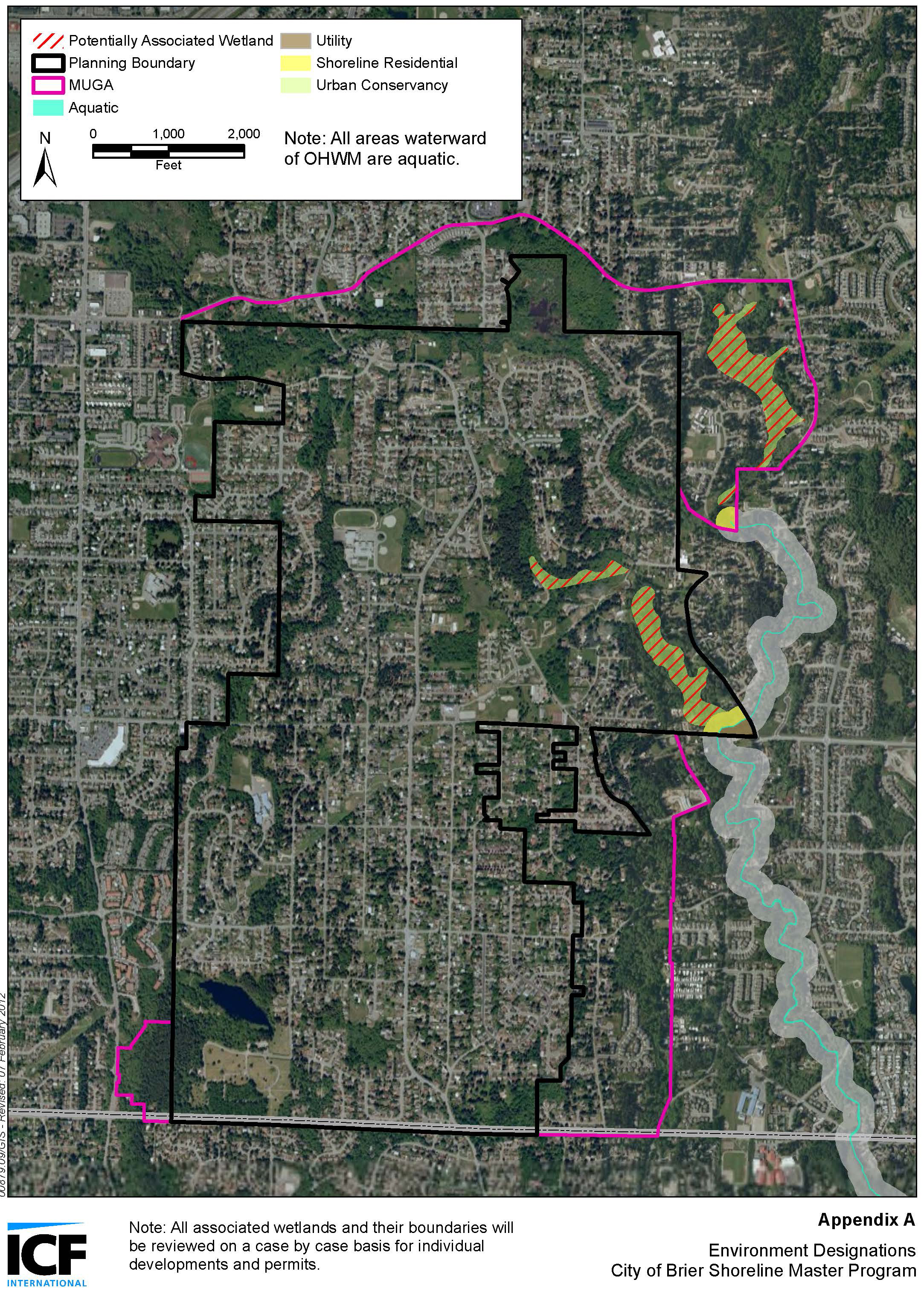
The twenty percent figure is based on WSDOT’s practices in determining whether sidewalks will be provided with state roads. (pers. com. Paula Reeves, WSDOT, email to WAAPA list serve, April 24, 2009).
The twenty percent figure is based on WSDOT’s practices in determining whether sidewalks will be provided with state roads. (pers. com. Paula Reeves, WSDOT, email to WAAPA list serve, April 24, 2009).