3. BICYCLING
Goal T-2: Interconnect bicycle facilities that are safe, nearby, easy to use and popular with people of all ages and abilities.
Background
Like walking, bicycling is a clean, healthy and efficient way to make many trips in a livable city. Today, many Kirkland residents would like to make more trips by bicycle; one reason they do not is because the current network of on-street bicycle lanes does not meet their needs for safety and convenience. In order to unlock the potential of bicycling, the existing network of on-street bicycle lanes should be improved with facilities that people of all ages and abilities find safe and welcoming. A large toolbox of options including, but not limited to, buffering and/or widening bike lanes, creating physical separation from traffic with parking or other means, building greenways and off-street trails should be developed to improve bicycle facilities.
Cities around the globe, including Portland, OR, and Vancouver, BC, have documented the relationship between more facilities for bicycling and improved safety. When top notch facilities are available, bicycle ridership increases and safety for all modes improves. This leads to more cycling, support for more facilities and further safety improvements.
For bicycling to be viable for people of all ages and abilities to make a wide variety of trips, bicycle parking must be widespread and plentiful, not just at commercial locations but at parks and transit facilities. Signing and marking for the bicycle network should be applied generously but in a way that fits with the surrounding neighborhood. Routes need to be supported by carefully chosen wayfinding that is integrated with that of neighboring cities. Kirkland’s terrain means that special treatments for bicycles should be considered at stairways and steep grades to help cyclists get up and down elevation changes.
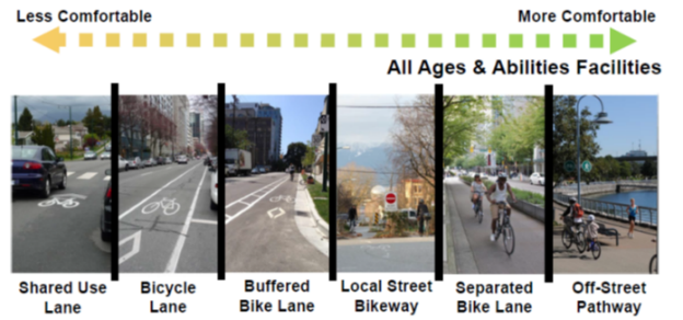
The graphic below shows The League of American Bicyclists’ definition of attributes that make a bicycle friendly community.
|
This illustration shows a spectrum of bicycle facilities. Those on the right are more comfortable for more users. In this illustration Greenways are called Local Street Bikeways. Source: City of Vancouver, B.C. |
Policy T-2.1: Make bicycling safer.
As with pedestrian safety, the vulnerability of cyclists to motor vehicles dictates that bicycle safety must be relentlessly pursued.
Bicycle use should be measured to understand trends in usage, where new facilities are needed. The impact of improved facilities on ridership must be measured. Volume data is needed to assess improvements while also used to identify and improve crash rates.
The same principles that apply to safety for other transportation modes apply to bicycling. Increases in safety will require a multi-disciplinary, multi-agency approach addressing more than the implementation of engineering solutions and more than simply keeping track of the number of bicycle crashes. Such efforts should be expanded at the City of Kirkland. (See Policy T-0.1.)
Policy T-2.2: Create new and improve existing on-street bike facilities.
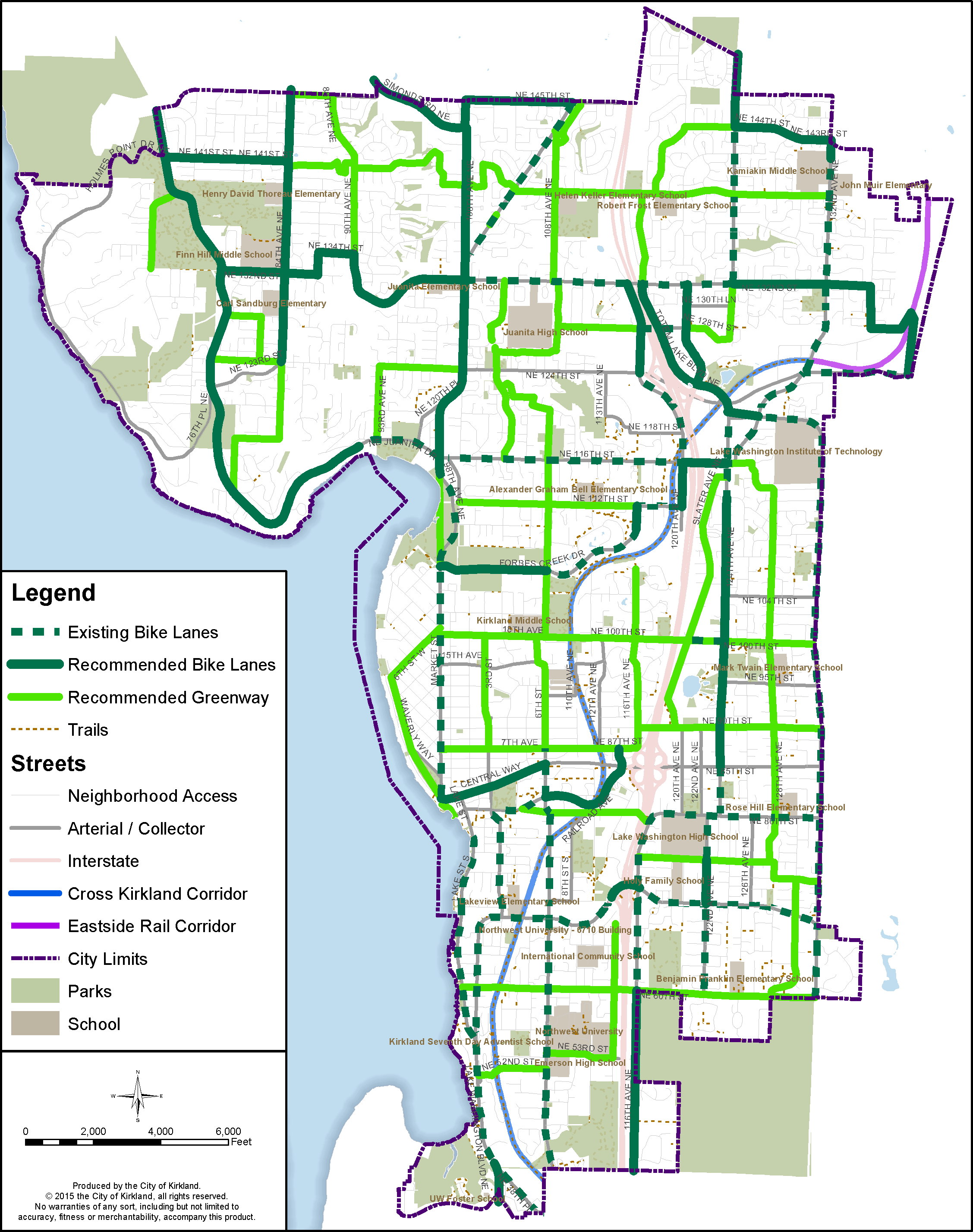
A system of on-street bicycle lanes currently forms the basis of Kirkland’s bicycle network and is likely to do so in the near future. Most of these bicycle lanes are of minimum width and have no barriers between auto and bicycle traffic. Research has shown that improving on-street bicycle lanes by widening, separating and/or buffering from auto traffic makes bicycling more attractive. The map below in this section shows a proposed network of bicycle facilities. One of the ongoing challenges for a bicycle network is the limited number of north-south arterials in Kirkland. The paucity of arterials forces auto and bicycle traffic together through the need for both auto and bicycle travel.
Many of Kirkland’s existing bicycle facilities can be made wider relatively inexpensively, through changing pavement markings; for example, new bicycle lanes can sometimes be created by narrowing auto lanes.
High quality, separated on-street bicycle facilities (formerly known as cycle tracks) should be part of Kirkland’s bicycling network. This concept is especially important along high volume/high speed arterials where bicyclists are threatened by automobile traffic and from door openings of parked vehicles. Sometimes these facilities may require separate traffic signal indications for bicycles. Higher levels of signing and marking could significantly improve the on-street bicycling experience and therefore the viability of bicycling. Continuing bike facilities through intersections where they are currently dropped, and including better signal detection would have similar effects. Methods for making these improvements and others should be detailed in a revised Active Transportation Plan.
Guidelines that illustrate enhanced bicycle facility design are becoming widely available and should be adopted by Kirkland.
Improvements to bicycle facilities should be prioritized based on their ability to meet the following goals:
• Improve safety – consider safety history and the potential to reduce conflicts.
• Link to Land Use – make connections to local and regional destinations and trails, with particular emphasis on the CKC, the Totem Lake Urban Center and the Greater Downtown Urban Center.
• Fill Gaps in the Network and Evenly Fill in the Network – prioritize projects that add geographic balance to the network or fill gaps between completed portions of the network. Consider routes on both sides of I-405 because of the impact of I-405 as a barrier for east-west connections and the limited number of north-south arterials.
• Connect to Transit – give higher priority to bicycle connections that lead to locations on the regional transit network.
• Community Support – give priority to projects that have broad community support.
• Cost/Likeliness to Receive Grant Funding – prioritize projects that have lower cost or that are good candidates for grant funding, but apply caution so that high cost, high value projects are also included.
Figure T-19: Bicycle Network
Policy T-2.3: Build a network of greenways.
Greenways are bicycle facilities on streets that have lower auto speeds and volumes. Greenways have special signing and marking and may have traffic calming features. Traditionally, they are on streets that are parallel to major streets to provide quick access to destinations located on such streets. Greenways can also include trails and paths that are off the street networks. Examples of this could include trails between cul-de-sacs or through parks. Other trail connections that are not necessarily part of greenways should also be completed with special emphasis on connections to Lake Washington and the Cross Kirkland Corridor. Where greenways cross arterial streets special treatments are usually needed. Ideally, greenways form a network that supports bike travel by itself, but together with the on-street network make an even more comprehensive network.
|
3 Attributes of an Ideal Greenway |
|
According to the NACTO Urban Bikeway Design Guide: |
|
1. Volume of cars is low; less than 3,000 vehicles per day. |
|
2. Speed of cars is low; less than 15% of drivers are traveling faster than 25 MPH. |
|
3. Crossings of major streets are designed to help bicyclists cross safely and efficiently. |
|
The ideal volume and speed requirements often suggest traffic calming measures. There may be situations where it is important to complete a segment of greenway even if the speed and/or volume targets can’t be achieved. Source: City of Seattle |
|
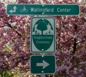
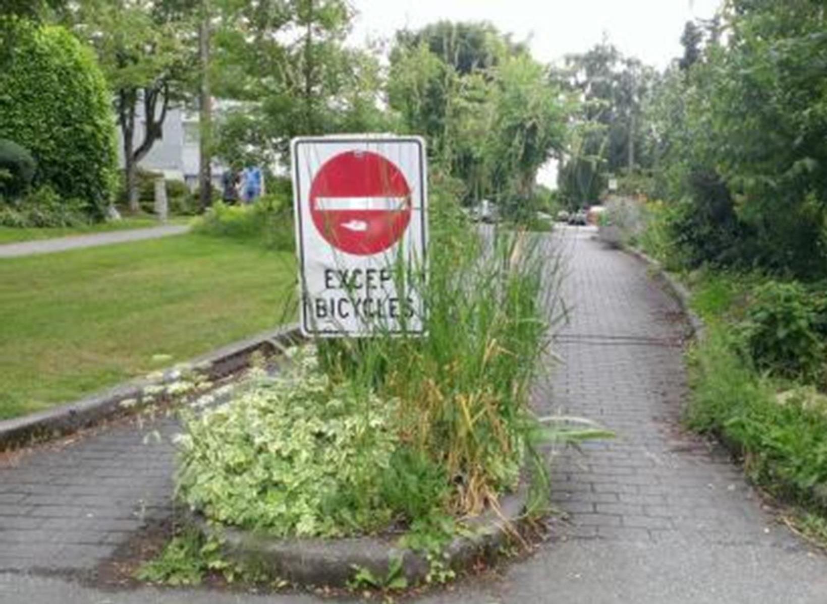
Greenway systems usually have consistent branding and naming along with strong wayfinding. To reduce car volumes, this diverter in Vancouver B.C. allows people on bicycles to pass through, but not motor vehicles. |
|
Greenways can have special facilities for people who walk. |
Priorities for greenway construction should reflect those in Policy T-2.2, including higher priority for those in 10-minute neighborhoods and those connecting to the CKC, parks or transit.
The bicycle network map on the previous page shows a network of bicycle facilities including a proposed greenway network. Adjustment to routes may be needed during the design of greenway improvement projects. Finalizing greenway routes should be done in consultation with neighborhood associations.
Policy T-2.4: Implement elements and programs that make cycling easier.
Secure, convenient parking is an important part of most bicycle trips. Policies that affect bicycle parking must accommodate increased bicycle usage and optimize the location of bicycle parking. The City should actively partner with the private sector to facilitate bicycle parking on both public and private property.
Bikeshare has launched in Seattle and the City should actively pursue bringing bikeshare to Kirkland. Kirkland should implement policies that remove barriers to bike sharing, including facilitating the location of bikeshare stations throughout the City. Bikeshare should complement transit, with stations at transit centers and hubs.
Because of Kirkland’s terrain, innovative devices that make climbing hills and using stairs easier should be pursued. Additionally route selection, wayfinding and other bicycle infrastructure should be designed to minimize the impacts of hills with the idea of making cycling accessible to many different types of cyclists.
Bike stations where a range of support items for cyclists are available, such as day use lockers, repairs, sales of bike parts, etc., should also be considered.
High-use cycling routes should be given more priority for bicycle friendly signal timing, street sweeping (including bike lanes), paving repair and other maintenance activities.
Policy T-2.5: Make it easy to navigate the bicycle network.
A system of bicycle wayfinding makes bicycling easier. It should be tied into the systems of surrounding cities and should identify direction and distance to important destinations along major routes. Advanced wayfinding techniques that incorporate more than signs should also be considered. Maps that provide value to cyclists should be developed. Because of the distance cyclists cover, this may mean partnering with other agencies to create a regional map that also covers Kirkland effectively. Bicycle wayfinding should be coordinated with pedestrian wayfinding and mapping efforts.
Policy T-2.6: Make the Cross Kirkland Corridor an integral part of the bicycle network and connect it to the region.
The Cross Kirkland Corridor is uniquely situated to serve many bicycle trips in Kirkland. The CKC Master plan describes how the corridor itself should be developed to suit this purpose. Links to the CKC have to be constructed and well signed to make the corridor fully connected and integrated to the bicycle network. (See Policy T-1.) Of particular importance is a connection to the Redmond Central Connector in the vicinity of Willows Road and NE 124th Street and a connection to the 520 Trail in Bellevue.
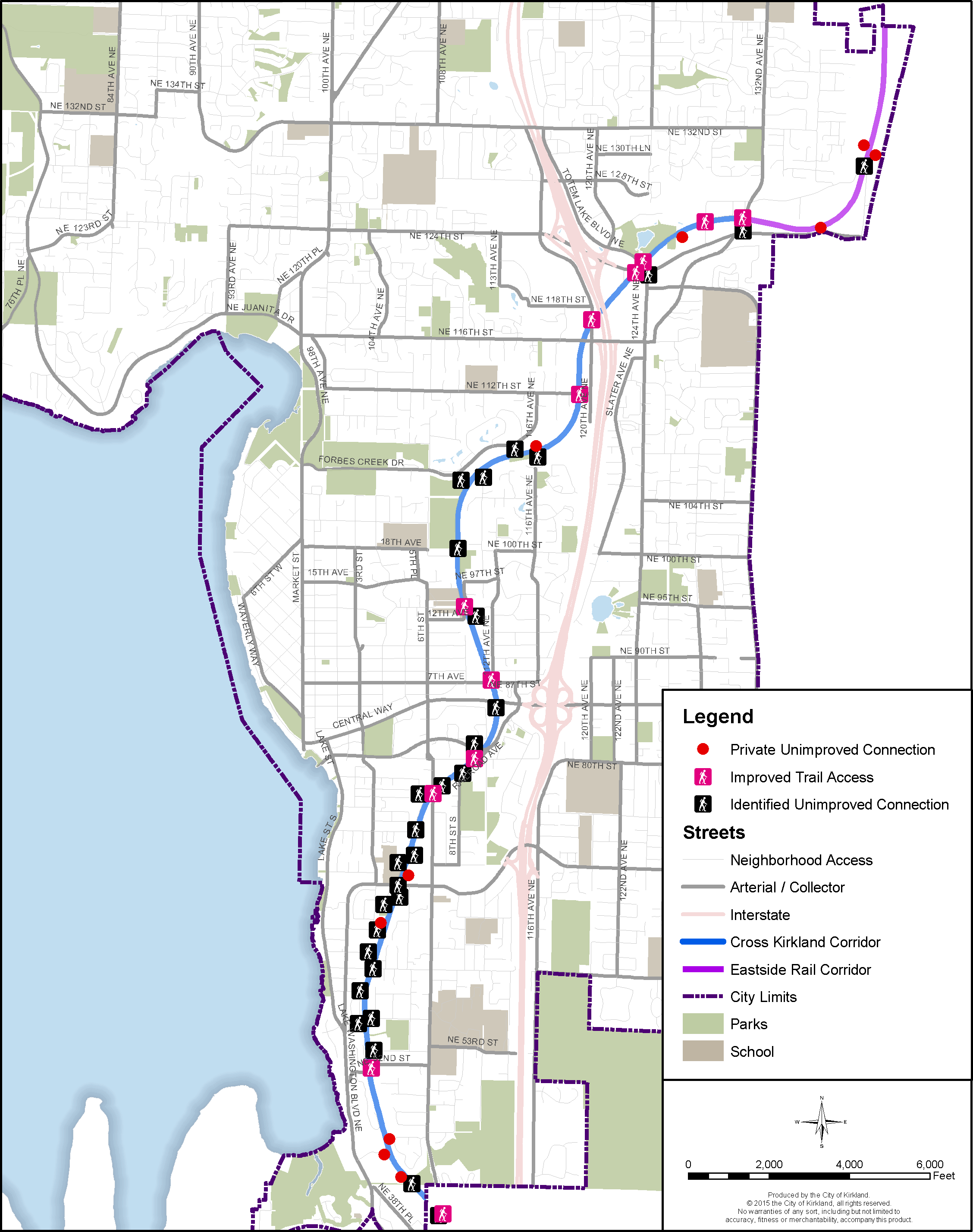
Figure T-20: Cross Kirkland Corridor and Connections
Below: Cross Kirkland Corridor’s connections to trails throughout the region.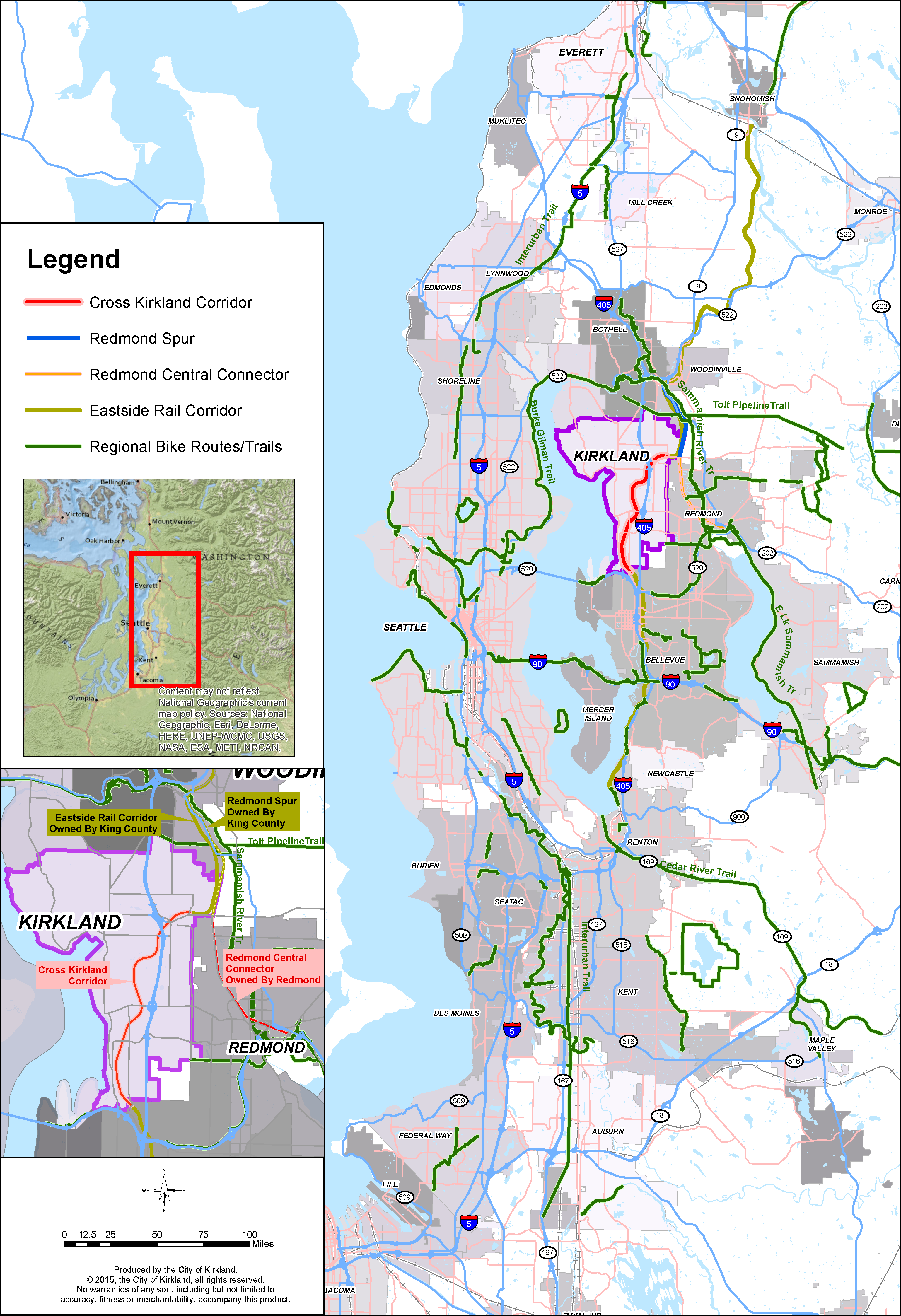
Figure T-21: Improved CKC and Other Regional Trails


