5. LAND USE
Existing Land Use
The Subarea is an important economic engine and activity center for the City. Existing land use within the Station Area Subarea is a mix of retail, office, residential, big box retail, auto oriented, and service and institutional uses. Within the Subarea, retail space forms the bulk of the commercial property, with 39 percent of land in office use.
The western part of the Subarea is home to a diverse mix of light industrial uses, offices, shops, and residential uses. Auto-oriented office buildings, light industrial, and multi-family complexes add diversity to the study area but lack pedestrian access and visual connections to the public realm. Adjacent to I-405 are larger parcels that include extensive surface parking lots, big box retail and auto sales uses, superblock development patterns, and auto-oriented streets.
The eastern portion of the Subarea is dominated by strip retail uses. This type of development is marked by large surface parking areas, auto-oriented services with frequent driveways and curb cuts, and a weak relationship to street frontages.
In several locations, pockets of office and residential development display an internal orientation, with little relationship to the street, surface parking, and poor pedestrian circulation. Smaller lot sizes for commercial properties along NE 85th Street result in multiple driveways along the street, presenting a future opportunity for shared driveways and an enhanced pedestrian environment.
Growth Framework
As Kirkland looks to the future, it will be critical to balance the existing community-valued characteristics of the Subarea today with new transit-oriented development that encourages a mixed-use, walkable urban district. The Subarea Plan will foster a mix of uses where housing, jobs, and destinations are within easy access to the BRT Station. The Subarea Plan supports transition of the area dominated by surface parking lots and similar car-centric features to development of a healthy, walkable, compact, equitable, and transit-oriented district that maintains a unique character and local culture.
The overall growth framework is aimed at supporting an inclusive, transit-oriented district that supports existing residents and businesses while offering more choices for living, working, learning, and visiting the area. As a transit-oriented community, the Station Area will incorporate a significant share of the City’s growth, in support of City and regional plans, and add more housing that is attainable for the jobs that will be created there.
Long term, the overall Station Area Subarea Plan Growth Framework is to:
• Generate more workforce and affordable housing.
• Attract new jobs to foster economic activity and offer the potential for better commutes.
• Include a diversity of commercial development across the Subarea.
• Foster an environmentally sound land use pattern that helps achieve the City’s sustainability goals.
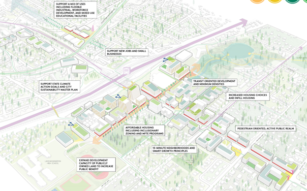
The Growth Framework focuses the most significant increases in development intensity in areas that provide clear benefits to the community and that leverage regional transit connections. This land use concept is the basis for creating form-based zoning code regulating districts. Increases in land use capacity and change are focused around the BRT Stride Station and the Cross-Kirkland Corridor. These are supported by an urban design framework that holistically brings together infrastructure and services within a future vision for shaping this growth to be community-oriented, as discussed in the Urban Design and Public Facilities sections.
The Framework also focuses on establishing mixed use areas of various intensities in areas that are currently zoned for commercial and industrial uses, and introducing lower scale missing middle housing types in those existing residential areas closest to the station. 
Figure 5: Growth Framework Illustration

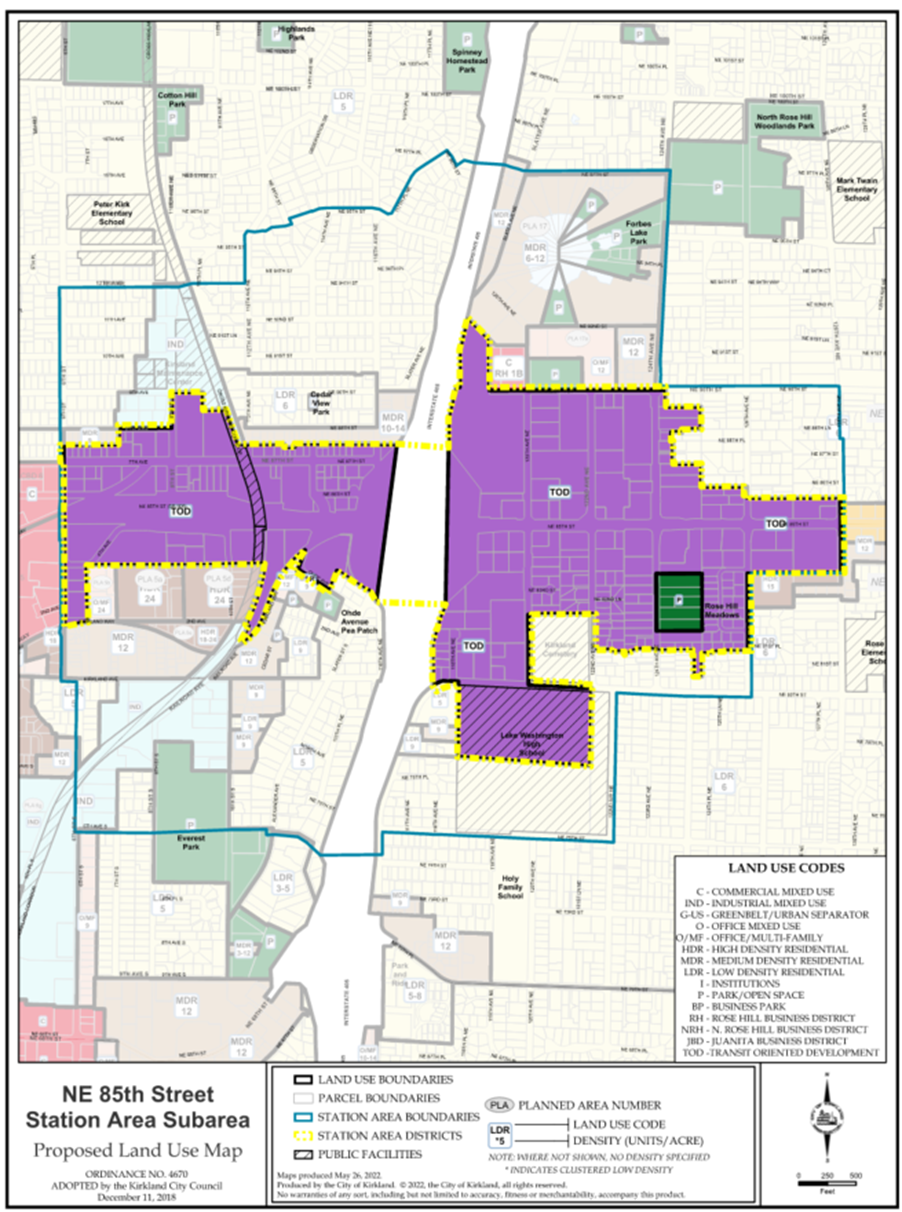
Figure 6: Station Area Land Use Map
Land Use Goals and Policies
Goal SA-1:
Establish residential and employment growth targets that accommodate a significant share of the City’s future growth, in support of Vision 2050 and the Regional Growth Strategy, with at least 45 activity units per acre.
Goal SA-2:
Encourage development intensities that create the capacity to accommodate higher growth targets for the Subarea in the future.
Goal SA-3:
Create opportunities for a diversity of housing types, accessible for all income levels and demographics, including affordable housing, senior housing, and special housing needs.
Goal SA-4:
Promote the Station Area as a district where all community members are welcome and celebrated.
Policy SA-5:
Station Area development standards and urban design principles should accommodate the following growth capacities.
|
Station Area 2044 Growth Capacity |
||
|---|---|---|
|
Existing 2020 |
Planned Growth Capacity 2044 |
|
|
Households |
1,909 |
8,152 |
|
Residential density (units/gross acre) |
2.69 |
11.48 |
|
Employees |
4,808 |
22,751 |
|
Employee density (jobs/gross acre) |
6.77 |
32.04 |
Policy SA-6:
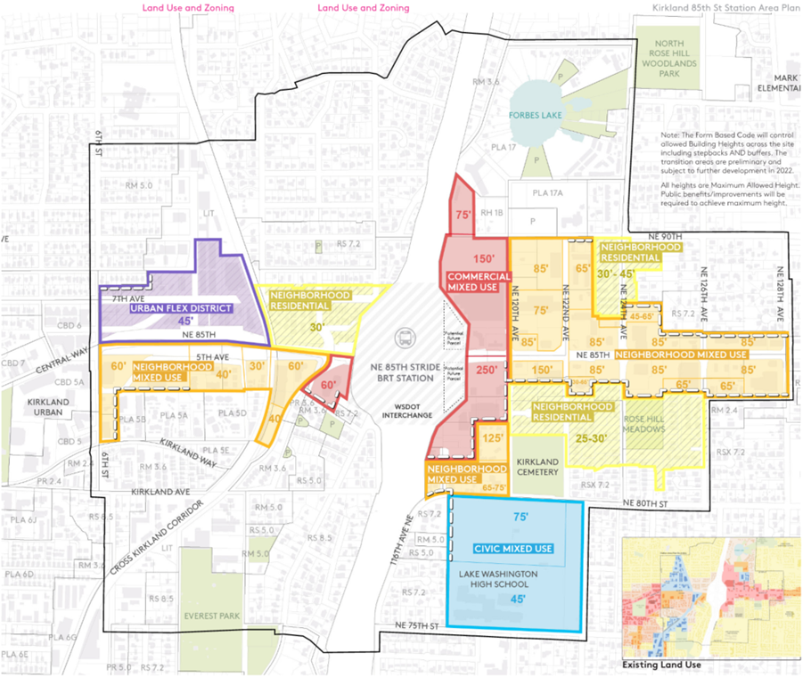
In cases where the Station Area planning process, including its associated environmental review, has established different development standards, the goals, policies, and direction on development standards for the Subarea Plan shall govern. This includes but is not limited to specific land uses, building heights, transportation improvements, and access requirements (for map of maximum allowed heights, see Figure 6).
Policy SA-7:
Establish design standards for pedestrian-friendly, transit-oriented development and other transit-supportive planning that orients land uses around transit. Eliminate superblocks with features such as through-block pathways to create a more fine-grained pedestrian-oriented district.
Policy SA-8:
Promote infill development, particularly on underutilized parcels.
Policy SA-9:
Ensure that implementation of the vision, goals, and policies related to inclusion and equitable access to housing and economic opportunities for people of color, people with low incomes, and historically underserved communities is achieved through intentional monitoring and periodic course corrections.
Policy SA-10:
Continue to support service providers such as King County Housing Authority, Helen’s Place, etc., that provide essential services to Kirkland community members, and identify additional opportunities to complement and enhance their services.

Figure 7: Maximum Heights Studied


