10. TRANSPORTATION AND MOBILITY
Vehicles and Street System
The Station Area has served as a crossroads for many years. Central Way/NE 85th Street has been the primary connecting route from Lake Washington to Redmond since 1907, and was also known as the Kirkland-Redmond Road. This corridor was also State Route 908, which ran from SR 520 north/south along Lake Washington Boulevard and east/west along Central/85th to I-405 until that segment was removed from the state route system and transferred to City ownership in 1992, and the segment from I-405 to Redmond was later decommissioned as a state route in 2010. Today, NE 85th Street continues to be an important east-west connector from Kirkland to Redmond and other east side communities, and the interchange at I-405 has provided regional north-south access since the interstate was constructed in the 1950s.
As a principal arterial, NE 85th Street has been designed to support throughput, moving motor vehicles between places. NE 85th Street has a right-of-way width of nearly 100 feet and a typical curb to curb width of 60 feet. With significant roadway volumes on NE 85th Street, and the north-south barrier of I-405 limiting east/west connectivity, these roadways have had a profound effect on the surrounding neighborhoods, creating physical and social barriers between the four quadrants of the interchange. Existing development is auto oriented with large parking areas and very little space devoted to walking and biking. The planned Stride BRT station and multi-modal access improvements present an opportunity to improve this condition. Moreover, in support of citywide and regional plans, the Station Area will accommodate a significant share of the City’s planned growth. The Station Area is a significant opportunity to develop a transit-oriented district and add more jobs, households, and improve the balance of land uses in the area and the city as a whole. The multi-modal infrastructure and services in the Station Area will support a proactive shift to a more people-oriented place that builds value for the City and community by promoting sustainable growth.
As a place to be, rather than to pass through, the Station Area will support and improve access to businesses, homes, schools, and open spaces. It will put people walking, bicycling, and taking transit first, while maintaining a manageable level of vehicular traffic. The planned transportation improvements have been designed to support multimodal mobility by increasing network connectivity, and providing safe intersections and crossings, and promoting comfortable streets for walking and bicycling.
The citywide Transportation Element chapter describes the current street classifications within the Station Area, including potential street and path connections and additional transportation goals.
The planned transportation improvements for the Station Area support a robust mobility network that bridges some of the existing barriers, increases network connectivity, and provides safe intersections and crossings.
As part of the Travel Demand Modeling and Forecasting Study conducted for the Subarea, the following infrastructure recommendations and policies were identified to support achieving objectives related to:
• Sustaining the vehicle throughput functionality of NE 85th Street as a principal arterial while enhancing its role as an urban street
• Incorporating transportation improvements appropriate to surrounding land uses and densities
• Accommodating effective transit service within the study area along transit corridors
• Establishing low-stress, connected bike and pedestrian networks
Vehicle and Bicycle Parking
With plans to support more walking, biking, and transit use, Subarea regulations should balance parking demand and parking management for people who live, work, and visit the Station Area, while reducing the negative impacts of parking to the area.
In addition, the following parking and Transportation Demand Management (TDM) strategies should be explored in the Station Area:
• Unbundling vehicle parking to separate parking costs from total property cost, allowing buyers or tenants to forgo buying or leasing parking spaces if they do not own a car.
• Implementing on-street parking management strategies (e.g., designate passenger loading/unloading zones, establish time limits).
• Requiring new development to charge for off-street parking.
• Encouraging or requiring transit pass subsidies from developers/property owners.
• Utilizing a Ridematch Program to assist potential carpoolers in finding other individuals with similar travel routes.
New Street Standards
As part of the urban design framework for the Station Area, new street design standards are proposed and will be required with the Form-Based Code regulations. These innovative street design standards will ensure that land use, design, and transportation objectives are coordinated as the planned transportation infrastructure is built-out by the public and private entities.
Mobility and Active Transportation Network
Pedestrian System – Existing Conditions
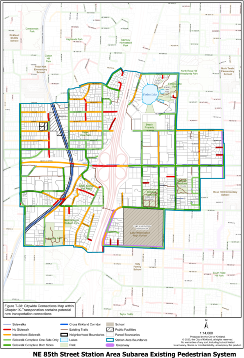
For people walking and biking, east-to-west connectivity is a significant challenge in the Subarea, especially from Downtown along NE 85th Street to the top of Rose Hill. NE 85th Street and Kirkland Way lack sidewalk coverage from the interchange itself west to 6th Street, a key route which connects the study area to downtown. Local streets have some sidewalks, however many of the adjacent commercial and industrial areas lack coverage. 120th Avenue NE, 122nd Avenue NE, NE 90th Street, and NE 80th Street lack consistent sidewalks. Many major streets have sidewalk coverage, with the prevailing sidewalk width varying between five to eight feet (see Figure 10).

Figure 10: Existing Pedestrian System
Pedestrian System Implementation Opportunities
Ensuring a safe and pleasant network for walking, biking, and other active transportation options for people of all ages and abilities is critical to the success of the Station Area Plan and a priority for the City. The active transportation network within the Station Area includes a number of specific recommended improvements to the active transportation network and there is mode-split goal identified for the Subarea.
A complete network of pedestrian accessible routes is intended to support the vision of the station area as a walkable, urban district. This includes a mix of expanded or improved sidewalks, green midblock connections that provide access through otherwise large blocks, and public spaces like plazas and parks which can function as pedestrian pass-through routes. A more complete network of sidewalks and pedestrian connections is also intended to provide more universal accessibility for users of all ages and abilities.
More detail about proposed multimodal improvements can be found in the Station Area Plan or the citywide Active Transportation Plan.
Supporting Transit
One of the main objectives for the Station Area is to facilitate easy access and use of the future Stride BRT station. In order to support a transit-oriented community, the plan considers ways to complement existing local routes, as well as the efforts around the K Line bus rapid transit line. The Station Area Plan includes complete street concepts for improvements to streets and greenways and coordinates shared use trails and other connections between transit stations and key services and destinations. An analysis of future transit service found that with planned growth, there may be a minimal travel time impact of one to two additional minutes on transit corridors within the Station Area.
Recommended Subarea improvements to enhance access to transit include:
• Construction of shared use trail connections to transit stops along NE 85th Street and the BRT station.
• Sidewalks widened along NE 85th Street throughout the Station Area.
• Complete street and greenway improvements on key routes accessing transit stops along NE 85th Street and the BRT station, including 5th Avenue, 7th Avenue/NE 87th Street, 116th Avenue, and NE 90th Street.
Bicycle Network – Existing Conditions
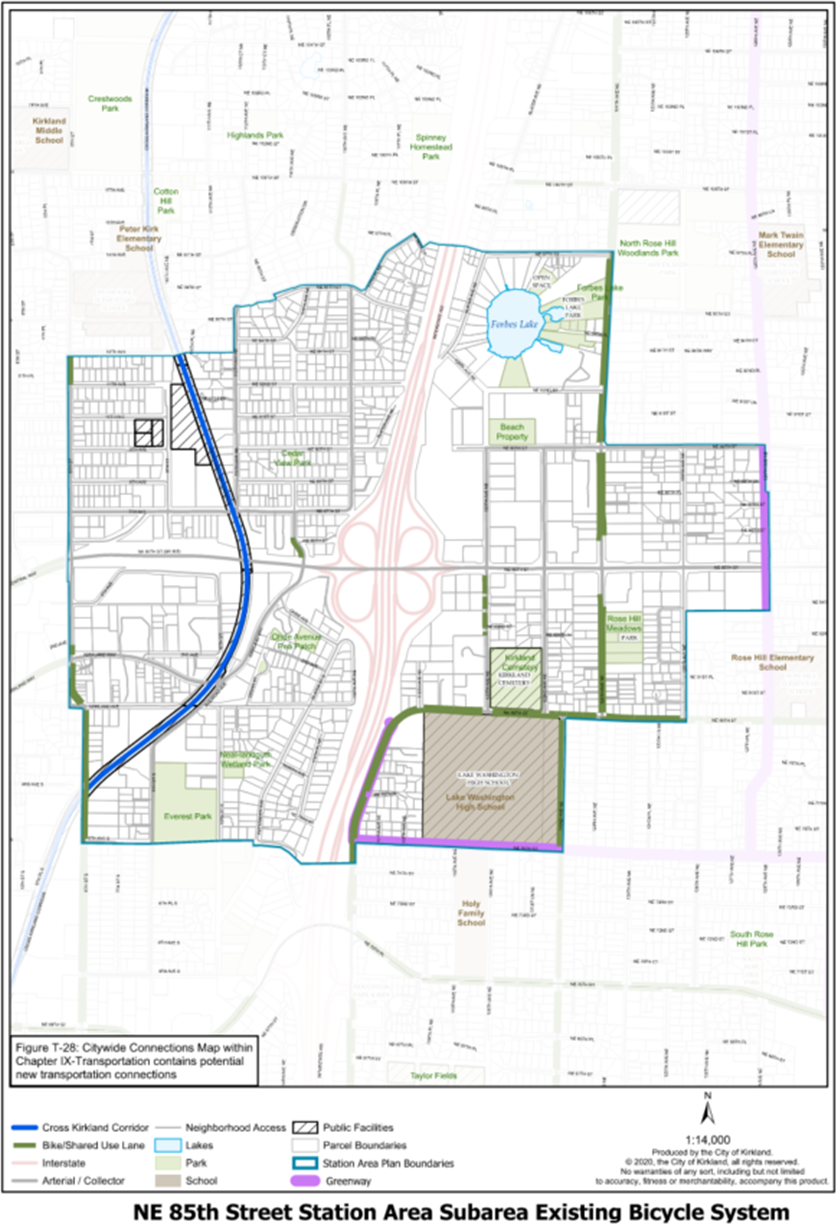
The Subarea and its environs lack continuous bicycle facilities. On the western side of the Subarea, the Cross Kirkland Corridor provides the most significant north/south connectivity, while partially buffered bike lanes on NE 80th Street and 124th Avenue NE act as the primary connections on the eastern side of the Station Area. There are also the newly completed North and South Rose Hill Greenways on 128th Avenue NE and NE 75th Street (Kirkland’s first two greenways) – neighborhood roads where walking and cycling are the primary travel modes and driving is the alternative.

Figure 11: Existing Bicycle System
Recommended Transportation Improvements
Transportation improvements were identified as part of the Station Area planning process to improve the active transportation network and accommodate safe crossings that reduce conflicts between modes of transportation, while managing vehicular congestion.
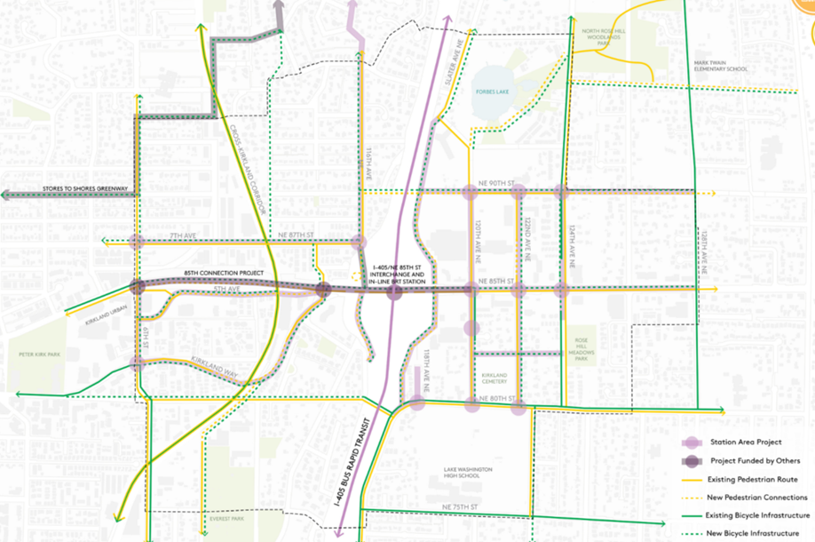
Select recommended projects are described below and will be evaluated for inclusion in the City’s Capital Improvement Program, and also implemented with new street standards set forth in the Form-Based Code for the Subarea. The full list of recommended Transportation improvements can be found in the Station Area Plan and appendices.
Figure 12: Proposed Transportation Infrastructure Improvements
• NE 87th/7th Avenue Corridor – Provide buffered bike lanes and consistent sidewalks between 6th Avenue and 116th Avenue NE. West of the Cross Kirkland Corridor, provide parking-protected bike lanes on the north side of the street. East of the Cross Kirkland Corridor, provide buffered bike lanes, and a five-foot landscape strip to enhance the street’s character.
• NE 90th Street Corridor – Between I-405 and 122nd Avenue NE, build a shared-use path or boardwalk on the north side of the street. Between 122nd and 128th Avenue NE, provide buffered bike lanes and sidewalks with landscape strips on both sides of the street.
• Compact Roundabout at NE 87th Street and 116th Avenue NE in the Highlands Neighborhood – Revise this intersection to be a compact roundabout that better accommodates people walking and biking, and access to the NE 85th Street Station pick-up and drop-off.
• 124th Avenue NE Widening and Protected Bike Lanes – Widen 124th Avenue NE to five lanes plus physically separated bike lanes from NE 85th Street through the NE 90th Street intersection. This project also includes continuation of protected bike lanes south through the NE 85th Street intersection to NE 84th Lane to connect to existing bike lanes.
• NE 85th Street Improvements – To offer a high-quality experience for people walking, biking, rolling, and making last-mile connections from transit, enhance NE 85th Street between I-405 and 128th Avenue NE by providing active transportation zones on both sides of the street that include one-way raised protected bike lanes, widened sidewalks, and wide landscape and amenity zones.
• NE 85th Street and 120th Avenue NE Improvements – As part of the overall enhancement to the NE 85th Street corridor to better accommodate all travel modes, multiple concepts were studied. A preferred concept direction would improve the NE 120th Avenue intersection to include an added eastbound lane as storage capacity from the interchange, an added northbound left turn lane to accommodate expected traffic volume increases, a bump out of the northwest corner to align with two westbound incoming lanes and reduce the north/south crossing distance, high-visibility crosswalks, shared use paths to the west connecting to the Stride BRT stations, and raised protected bike lane and wide sidewalks to the east.
Transportation and Mobility Goals and Policies
The main multimodal goals throughout the Subarea are to support mobility; to increase opportunities for people to walk, bike and roll, and take transit to key services and destinations; and to manage vehicular congestion.
Goal SA-63:
Provide a sustainable, equitable, affordable, safe, and efficient multimodal transportation system, with specific emphasis on an integrated regional transit network that supports the Regional Growth Strategy and Regional Transportation Strategy and promotes vitality of the economy, environment, and health.
Goal SA-64:
Achieve the following mode-split goal, or one that decreases SOV trips additionally, by the Station Area horizon planning year of 2044:
|
Quadrant |
SOV |
HOV |
Transit |
Walk/Bike |
Total |
|---|---|---|---|---|---|
|
Northwest |
48% |
14% |
13% |
25% |
100% |
|
Northeast |
48% |
14% |
14% |
24% |
100% |
|
Southwest |
49% |
14% |
18% |
20% |
100% |
|
Southeast |
46% |
14% |
16% |
25% |
100% |
|
Total |
47% |
14% |
15% |
24% |
100% |
Source: Fehr & Peers.
Goal SA-65:
Create a pedestrian-scaled network.
Goal SA-66:
Create a low-stress network for biking and rolling.
Goal SA-67:
Develop and implement a bold vision of a multimodal transportation network in the Station Area that prioritizes pedestrians, cyclists, and other nonmotorized modes.
Policy SA-68:
In order to achieve the aggressive mode-split goals, the City should require development to pursue aggressive Transportation Demand Management strategies that could include, but are not limited to:
○ Unbundle parking to separate parking costs from total property cost.
○ Revise parking code to reduce the parking minimums or implement parking maximums.
○ On-street parking management strategies.
○ Require new development to charge for off-street parking.
○ Require robust monitoring and management of parking and TDM measures to reduce spillover parking.
○ Encourage or require transit pass subsidies from developers/property owners.
○ Expand upon Kirkland’s Green Trip program and encourage alternative commuting modes.
○ Provide an Emergency Ride Home program for employees.
○ Require bike facilities such as storage and showers in new developments.
○ Encourage carpooling with a Ridematch Program.
○ Provide shared off-street parking with new developments.
○ Provide private shuttle service or gondola as a first mile/last mile solution to make the 85th Street Station more accessible from Downtown Kirkland, the 6th Street Google campus, Kirkland Urban, and other destinations.
○ Encourage or require transit pass provision programs for residents of multifamily properties.
○ Partner with Transportation Network Companies (TNCs) such as Uber or Lyft to provide pooled ridesharing alternatives.
○ Launch a bikeshare or other micromobility system in Kirkland.
Policy SA-69:
Develop an integrated multimodal transportation network (pedestrian and bicycle/rolling facilities, and linkages to adjacent neighborhoods and districts).
Policy SA-70:
Preserve the vehicle throughput functionality of NE 85th Street as a principal arterial while enhancing its role as an urban street.
Policy SA-71:
Incorporate vehicular network transportation improvements appropriate to surrounding land uses and densities into required improvement lists.
Policy SA-72:
Ensure effective transit service within the study area along transit corridors, particularly during peak commute hours.
Policy SA-73:
Encourage and support high-frequency, broad destination transit throughout the Station Area.
Policy SA-74:
Develop full street standards that serve all users, including pedestrians, bicyclists, other wheeled transport (e.g., scooters), transit users, vehicles, and – where appropriate – freight (to achieve a “complete streets” vision).
Policy SA-75:
Establish parking ratios that reflect the vision for a vibrant transit-oriented district, and recommended transportation investments to achieve a balanced multi-modal network, along with robust Transportation Demand Management (TDM) strategies for future development.
Policy SA-76:
Utilize tools like residential permit parking zones, enhanced monitoring, and enforcement to ensure that Station Area nodes like the Sound Transit pick up and drop off facility do not result in detrimental parking impacts to surrounding neighborhoods. These same tools should be used to ensure that employees of large commercial projects utilize private parking and the available array of alternative transportation options and do not park in surrounding neighborhoods.
Policy SA-77:
Prioritize the completion of a pedestrian network in the Station Area with sidewalks that are of sufficient width and configuration to accommodate the person trips resulting from forecasted growth and that support achievement of the Station Area mode-split goal.
Policy SA-78:
Provide a consistent, connected network for walking, bicycling, and rolling.
Policy SA-79:
Provide more protection and comfort for walking, bicycling, and rolling, particularly on high-speed, high-volume roadways such as 124th Avenue NE.
Policy SA-80:
Provide delineated biking and rolling space in the enhanced sidewalks on NE 85th Street.
Policy SA-81:
Improve safety for people walking, bicycling, and rolling through intersections.
Policy SA-82:
Identify planned transportation investments, programs, and resources, including transit, pedestrian and bicycle facilities and amenities, and projects to eliminate superblocks or modal conflicts and promote safety and connectivity.


