6. Environment, Parks and Open Space
This section provides policy direction regarding the natural environment in the Totem Lake Business District. Broad Citywide policies and standards for development regarding environmental quality, natural amenity and function, environmental hazards and stormwater management are found in the Environmental Element (Chapter V). These policies, while not repeated here, are applicable to the Totem Lake Business District.
Goal TL-5: Enhance the biological integrity of Juanita Creek and Forbes Creek.
Policy TL-5.1: Enhance the habitat quality of the Juanita Creek corridor.
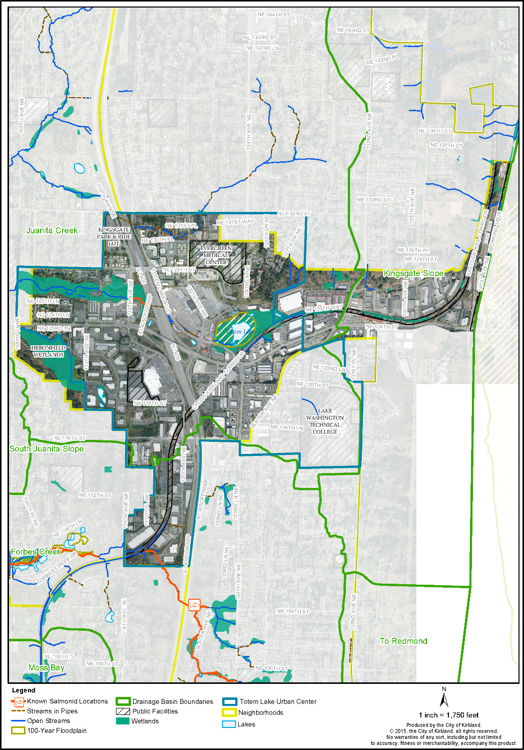
Juanita Creek and associated wetlands represent the largest continuous wildlife habitat area in the Totem Lake Business District (see Figure TL-3). While a valuable public resource, Juanita Creek has been negatively affected over the years by surrounding development. Impacts include narrow and degraded buffers, habitat fragmentation, degraded water quality, and increased flooding.
The City should initiate and support efforts to enhance the biological integrity of Juanita Creek, such as requirements for improved/enhanced buffers and reduced impervious surface area, partnership with other agencies or interested parties for improvements, acquisition of key areas or other measures.
Policy TL-5.2: Restore the natural Forbes Creek channel through the business district.
Within the Totem Lake Business District, the Forbes Creek channel is culverted, which eliminates opportunities for wildlife habitat. Outside of the business district, open portions of Forbes Creek provide cutthroat trout and Coho salmon habitat. With restoration, it may be possible to re-introduce these species to the Totem Lake Business District portion of the stream.
Rehabilitation of this stream corridor could restore biological health and diversity within the corridor, possibly re-establish a salmon run, and provide a visual amenity. City efforts should include a requirement that adjacent new development/redevelopment open and restore stream segments and/or direct public investment to restore the corridor. Development activity that restores the stream corridor should be allowed to retain development potential that would otherwise have been reduced by stream restoration.
Policy TL-5.3: Coordinate with the Federal Emergency Management Agency to update the floodplain map for the Totem Lake Business District.
Existing floodplain maps indicate that the only area that lies within the 100-year floodplain is Totem Lake. The Federal Emergency Management Agency (FEMA) originally developed these maps in the 1960s. Due to changes in local topography and stormwater patterns associated with development, these maps may no longer be accurate. The City should seek funding to review and update these maps as needed.
Goal TL-6: Enhance the natural condition and function of Totem Lake.
Policy TL-6.1: Work collaboratively with other agencies and groups to improve the habitat value and function of Totem Lake.
Totem Lake and wetlands include forest, shrub, and emergent communities, together with open water. This mix of communities creates a variety of habitat opportunities for wildlife in this headwater area of Juanita Creek. This area is bordered with little buffer area on the west, south and east sides by commercial development, roads and railroad tracks. Wooded slopes to the northeast provide upland area and wetland buffer features lacking along other sides.
Totem Lake is owned by the King Conservation District (KCD), a special purpose district that provides education and technical support on resource conservation issues. The management goals for Totem Lake are to enhance the wildlife habitat and maintain the area for passive recreation. Because the KCD has limited resources, management occurs on an incremental basis, as funds are available.
In cooperation with the KCD and the Eastside Audubon Society, the City of Kirkland conducts regular maintenance to remove trash and remove overgrown vegetation. Future collaboration between the City, the KCD and the Eastside Audubon Society should enhance the overall habitat value and function of Totem Lake.
Figure TL-3: Totem Lake Wetlands, Streams, and Lakes
Policy TL-6.2: Provide opportunities for people to observe and enjoy the wildlife habitat around Totem Lake.
Totem Lake provides valuable urban wildlife habitat, with a wide diversity of birds and other animals. Currently, there is a boardwalk trail through a portion of the wetland that allows visitors to observe a variety of wetland types and wildlife activity, particularly water birds, songbirds and woodpeckers. Increased opportunities for public education and wildlife interpretation at Totem Lake, while protecting the natural system, could increase public appreciation and stewardship of this valuable resource.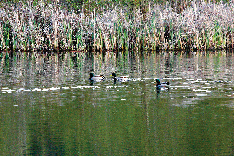
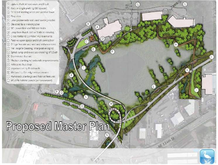
Policy TL-6.3: The City should acquire Totem Lake and develop park improvements as identified in the Totem Lake Park Master Plan.
To ensure that the quality of Totem Lake and its buffers are preserved through regular maintenance, the City should seek to acquire and manage this resource. The 2013 Totem Lake Park Master Plan identifies improvements that can be made to enhance ecological function, increase opportunities for environmental education and interpretation, and better connect the park to the surrounding business and residential communities and to the adjacent Cross Kirkland Corridor. The City should implement the park master plan.
Policy TL-6.4: Work with other agencies and the public to improve water quality.
The water bodies in the Totem Lake Business District are generally rated as “fair” to “good.” All, however, have been routinely diagnosed with such water quality problems as high fecal coliform, low dissolved oxygen and high temperatures. Runoff from streets, parking lots and yards is a major contributor to water quality problems. The City should address water quality issues in accordance with the 2014 Surface Water Master Plan.
Goal TL-7: Establish a green corridor extending in an east/west direction from the hillside northeast of Totem Lake and extending along the Juanita Creek corridor.
Policy TL-7.1: Create a public green corridor as shown in Figure TL-10.
Green corridors offer a mechanism to link the community’s cultural, historic, recreational and conservation needs. The term “green corridor” combines the concepts of greenbelt and parkway: providing the separation and ecological functions of a greenbelt and the linear and connective orientation of a parkway. Green corridors help to preserve natural areas, habitat, and stream corridors and provide open space within developed areas. With their emphasis on connectivity, green corridors support wildlife by creating corridors and providing buffers from roadways and other incompatible uses.
In the Totem Lake Business District, a new public green corridor should extend from the steep slope in the eastern portion of the district, through Totem Lake and the Juanita Creek corridor to the western edge of the district (see Figure TL-10). The green corridor would encompass many of the Juanita Creek Basin wetlands on the north side of NE 124th Street (see Figure TL-3). These wetlands include both small isolated features and large wetlands, such as those along Juanita Creek. Currently, these features provide significant wildlife refuge opportunities, limited primarily by fragmentation. Their wildlife function would be greatly expanded with a green corridor that provides a continuous travel route.
Public and private landscape improvements to the area between Totem Lake on the east side of I-405 and Juanita Creek on the west side of I-405, should be incorporated into the green corridor to provide a continuous corridor through the business district.
Policy TL-7.2: In landscaped areas of the green corridor, encourage landscape materials that complement adjoining natural areas.
Certain portions of the green corridor, particularly extending west from Totem Lake and across I-405 to the Juanita Creek corridor, should be landscaped to provide a continuous green path through the business district. To the extent possible, these areas should be landscaped with materials that complement the natural areas of the green corridor and continue the appearance of a natural green corridor.
Policy TL-7.3: In natural areas of the green corridor, maintain the natural vegetation to the greatest extent possible.
Within the natural areas of the green corridor, natural vegetation, wildlife habitat and stream corridors should be maintained to the greatest extent possible. This may include management to replace invasive non-native plants with native vegetation. This will enhance the overall habitat and stormwater control function of these areas.
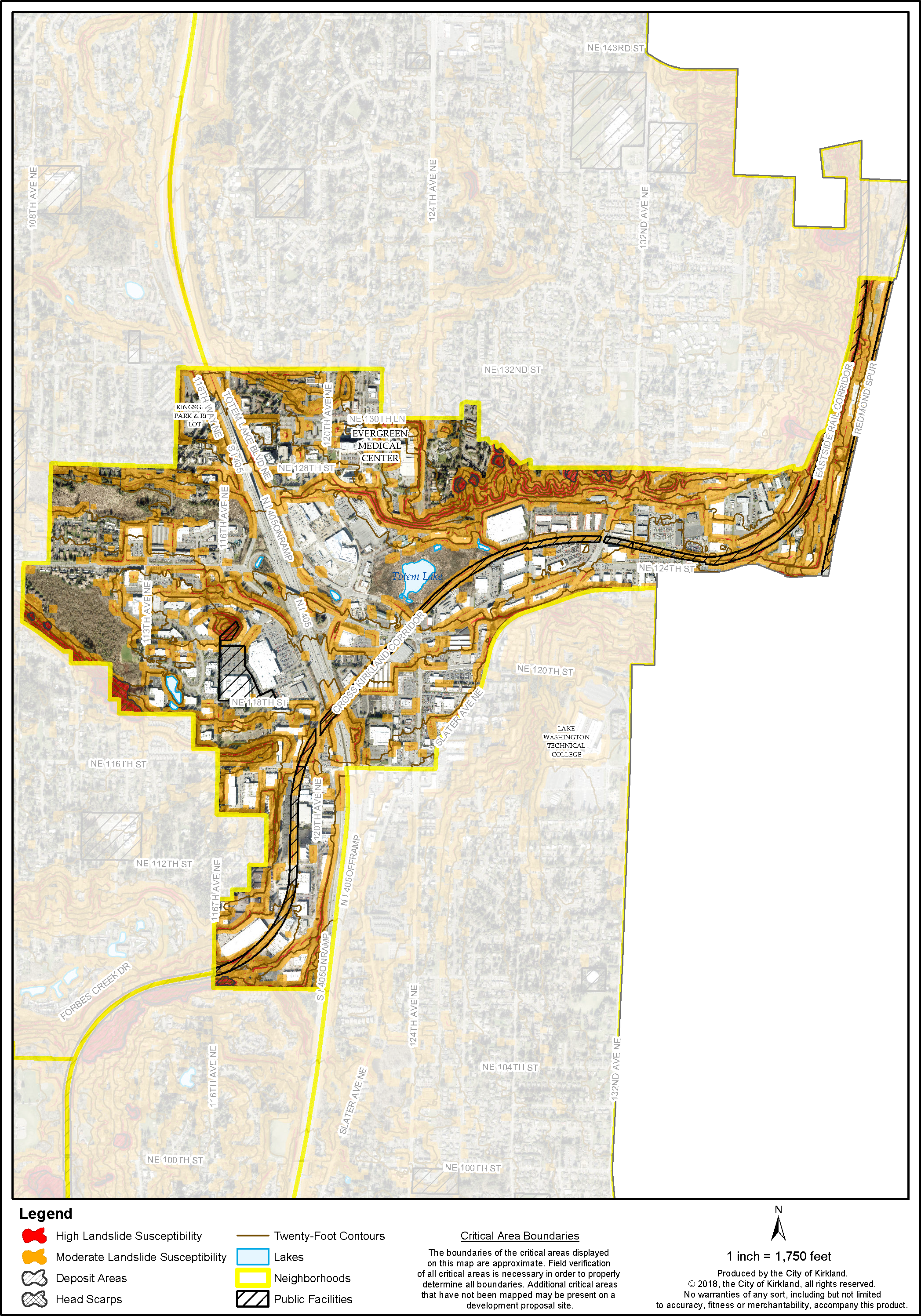
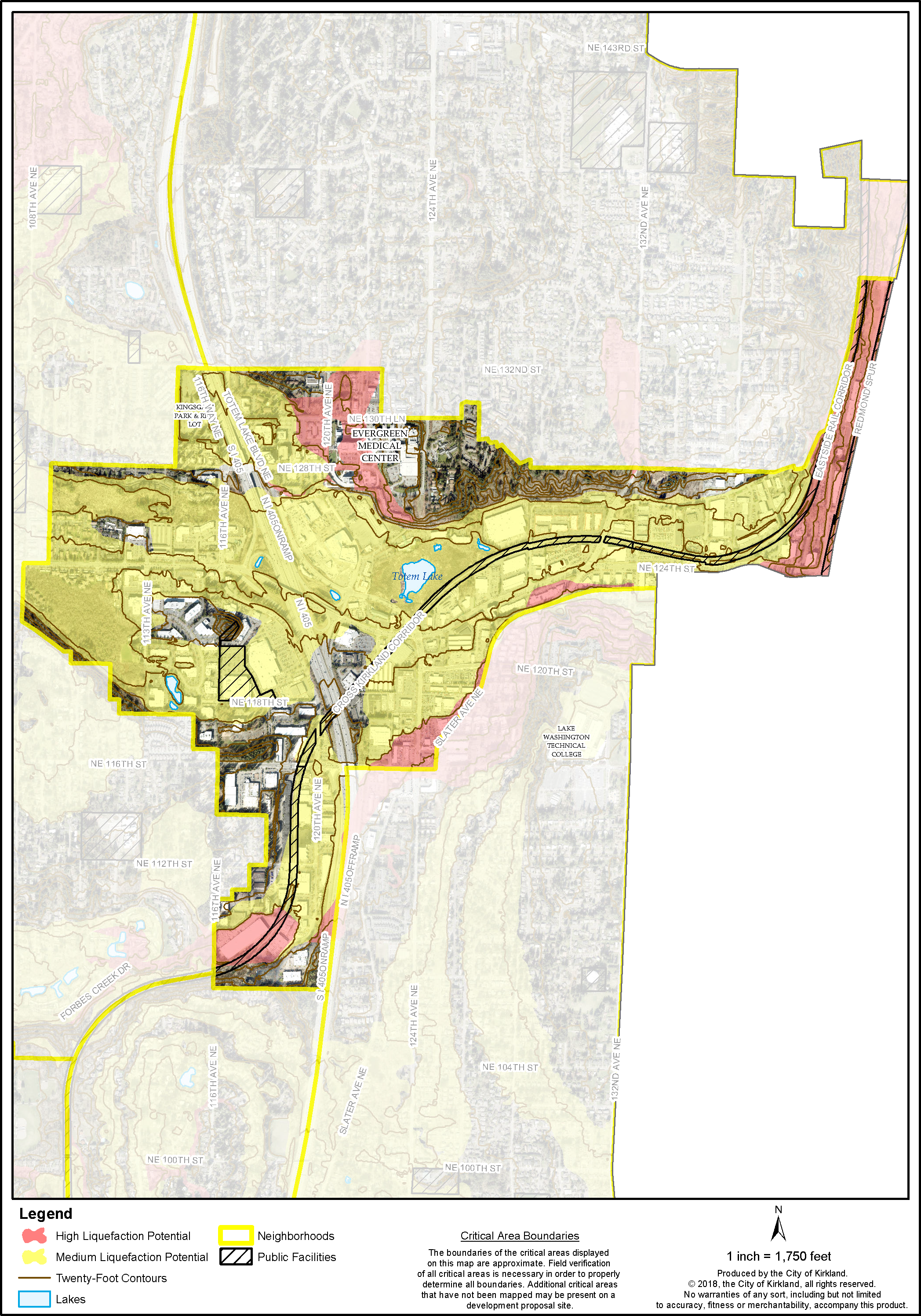
High and moderate landslide areas are located throughout the Totem Lake Business District. Primary areas at risk for landslide include the slope northeast of Totem Lake, the slope south and west of the Heronfield wetlands, Welcome Hill, and isolated areas in the South Industrial-Commercial Subarea and along the north side of Juanita Creek (see Figure TL-4a). Seismic soils are located primarily in low-lying soft soil areas around Totem Lake, along Juanita Creek and around the Heronfield wetlands. Currently, the only 100-year floodplain in the Totem Lake Business District is located around Totem Lake. Policies in this section provide general guidance regarding these features.
Goal TL-8: Protect potentially hazardous areas, such as landslide, seismic and flood areas, through limitations on development and maintenance of existing vegetation.
Policy TL-8.1: Maintain existing vegetation in high or moderate landslide areas.
In all landslide areas, most of the existing vegetation should be preserved in order to help stabilize the slopes as well as maintain natural drainage patterns. In particular, areas with significant existing vegetation, such as the wooded ridge along NE 116th Street and the hillside northeast of Totem Lake (Figure TL-4a), should retain vegetative cover to the maximum extent possible.
Goal TL-9: Acquire and develop community facilities, such as a neighborhood park and community center.
Policy TL-9.1: Establish an open space network.
The network should include open space, a neighborhood park, and pedestrian corridors. Park and open space facilities should be sized and designed to meet the needs of shoppers and those who live and work in the area. The facilities should include at least one place to gather, rest, eat and engage in informal recreation. Trees and plants should be provided for shade and relief.
Figure TL-4a: Totem Lake Landslide Susceptibility
Figure TL-4b: Totem Lake Liquefaction Potential
Policy TL-9.2: Public/private partnerships should be encouraged to provide additional parks, open space and pedestrian corridors.
Future intensive residential, office and retail development particularly in the core of the business district will increase the demand for parks, open space and pedestrian corridors. New development will also provide increased opportunity for acquiring and integrating open space amenities into the development pattern. The City should seek opportunities to work in partnership with private development to create public open spaces in the business district that benefit public and private interests. The Park Recreation and Open Space Plan has identified the need for further improvements in Totem Lake (see the PROS Plan for further details).
Policy TL-9.3: Support the creation of community centered functions and activities.
New community-oriented facilities in the Business District Core would provide recreation space that is highly in demand, increase activity levels in the area and provide a magnet for future private development. A new public facility, such as a community and recreation center, or the provision of space for these functions through private development would be a significant contribution to the future of the core area. Incentives for the development of community-oriented facilities through private development should be implemented.
Examples of program activities that might occur at a community center would include those that would support increased awareness and stewardship of the Totem Lake wetlands, individual and family health and fitness activities, and other community activities that complement plan goals for the Business District Core and the Totem Lake Business District as a whole.
Goal TL-10: Maximize opportunities provided by the Cross Kirkland Corridor for new parks, open spaces and recreational activities in Totem Lake.
Policy TL-10.1: Ensure when new development, redevelopment or exterior remodeling occurs adjacent to the Cross Kirkland Corridor that the building and site features integrate with the corridor to create active and engaging spaces for corridor users.
The former rail corridor, now known as the Cross Kirkland Corridor (CKC) where it is under Kirkland ownership to 132nd Avenue NE, and as the Eastside Rail Corridor to points east and north, runs diagonally through the Totem Lake Business District. Opportunities for recreation and connection presented by this swath of open space should be maximized by neighboring properties, consistent with the objectives established in the PROS Plan and 2014 CKC Master Plan.


