7. Transportation
The Eastside has experienced increased traffic as a clear result of ongoing growth trends. Various transportation programs have set forth regional policies to handle this situation as it transcends any single jurisdiction. As with most of Kirkland, Juanita is located such that it is heavily impacted by the region’s weekday rush hour traffic.
The transportation system should serve local and regional needs.
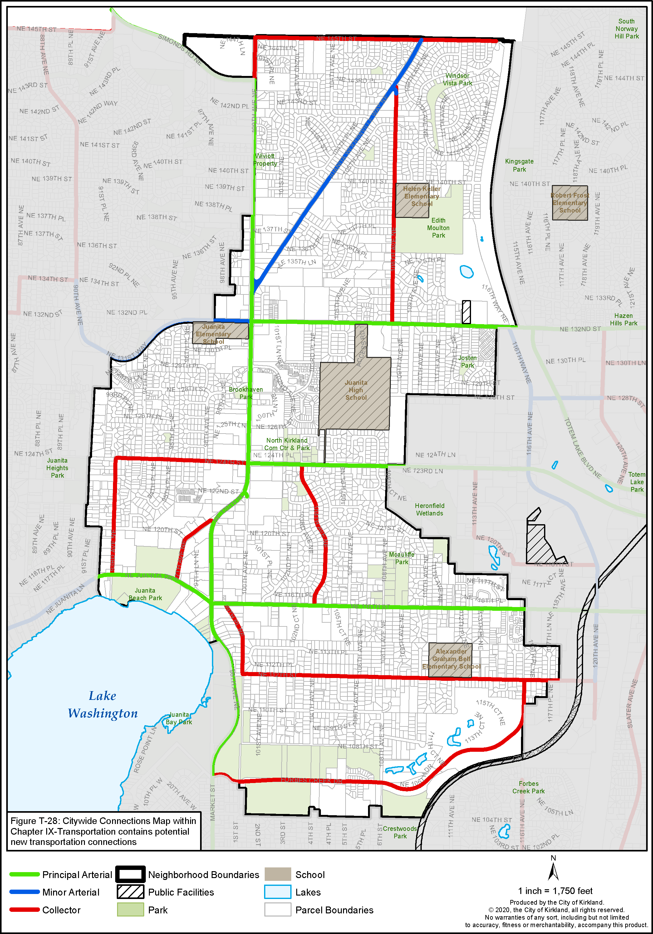
The transportation system in Juanita should provide a network of safe streets to serve the residents, while recognizing and serving the regional needs. The neighborhood is divided by the following principal: 100th Avenue NE, NE 116th Street, NE 124th Street, NE 132nd Street (Figure J-5). These streets are heavily traveled by local residents and commuters from outside the neighborhood. These streets and Juanita Drive and Juanita-Woodinville Way NE, which are minor arterials, take commuters to and from I-405. Future improvements should recognize this situation and protect the integrity of the residential neighborhoods.
The following is a list of priorities desired for the transportation network in Juanita:
• NE 132nd Street – The City should improve this street to provide safe access to and from Finn Hill, particularly near Juanita Elementary.
• 100th Avenue NE north of NE 124th Street – A 100th Avenue NE Corridor Study for the street segment between NE 132nd Street and NE 145th Street recommended intersection, crosswalk, access control, lighting, signing, bike lanes and other street and stream improvements to the corridor. As funding is available these improvements should be implemented.
• Juanita Drive – See discussion in the Juanita Business District section and approved Juanita Drive Master Plan.
Figure J-5: Juanita Street Classifications
• NE 145th Street/100th Avenue NE intersection – Add a City or neighborhood gateway sign and improve pedestrian crossings.
• Consideration should also be given to the use of native, drought-tolerant plant materials along streets. In addition, every effort should be taken to retain significant trees in the right-of-way during construction of streets.
• A new emergency, pedestrian and bike overpass across I-405 at approximately NE 140th Street connecting Juanita, Totem Lake and Kingsgate neighborhood is desired.
• Measures should be taken to reduce the speed of traffic on all Collector Streets through residential neighborhoods.
Further discussion of planned transportation improvements are described in the Transportation Element and Transportation Master Plan.
BICYCLE FACILITIES
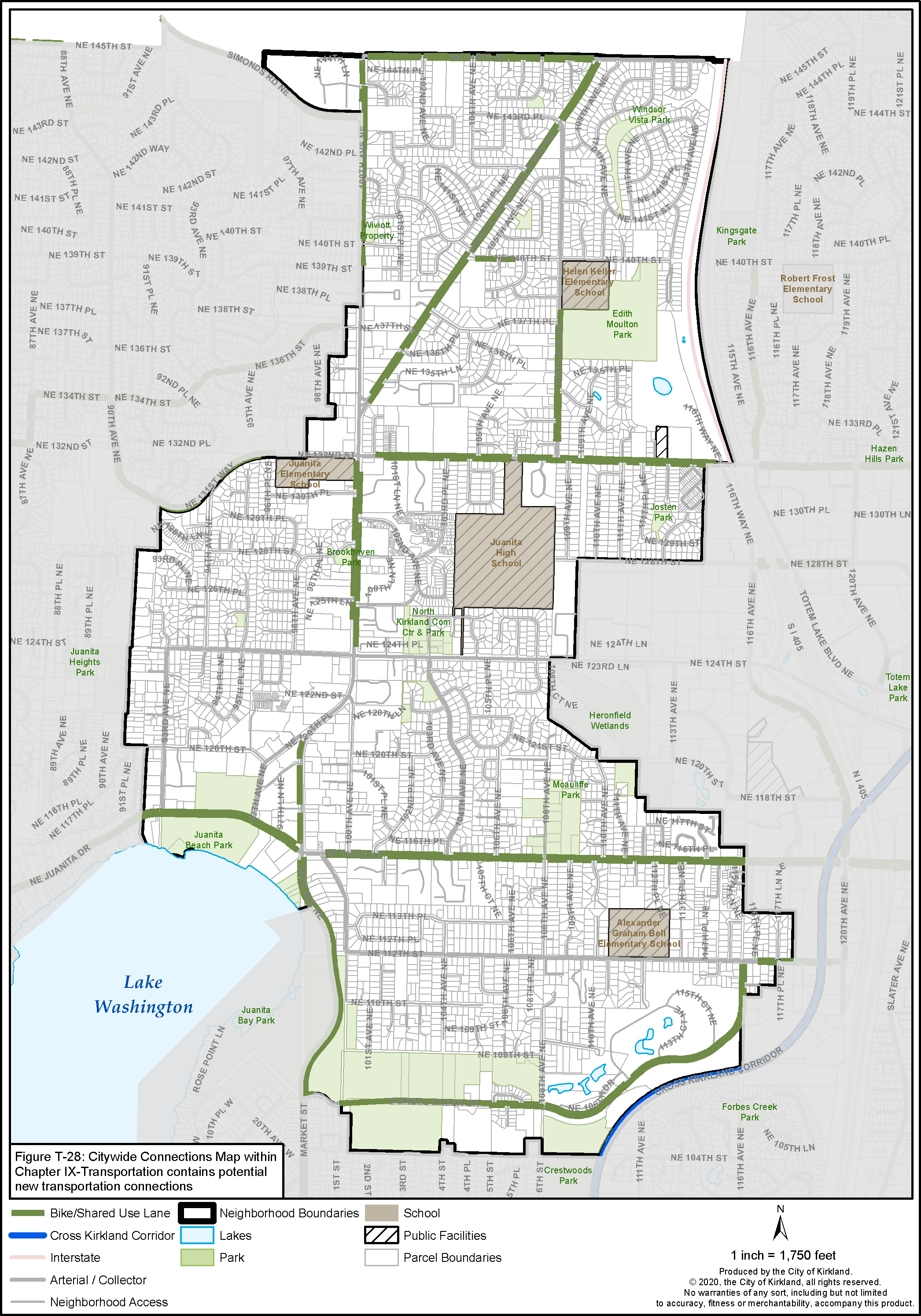
Bicycles are permitted on all public streets, but several streets in Juanita are designated in Figure J-6 to be improved bicycle routes. Improvements for bicycles can include a separate lane, signs, or simply a wide shoulder. Improvements for specific streets are to be made as part of the City’s Capital Improvement Program.
King County has a special bicycle route called the “Lake Washington Loop” so riders can ride around the lake. In Juanita, this route follows 98th Avenue and Juanita Drive.
A designated bicycle route should be identified between Finn Hill, Juanita Beach Park, the Cross Kirkland Corridor and the Sammamish Valley Trail.
Similarly, the City should work to identify the best bicycle route between Finn Hill, Juanita Beach Park, Cross Kirkland Corridor and the Sammamish Valley Trail in Redmond. The route should be clearly marked and tied with facilities in the Totem Lake Neighborhood. See also the Transportation Master Plan.
Access easements are encouraged to connect with pedestrian and bicycle corridors.
The Parks, Recreation and Open Space Plan (PROS) identifies two signature bicycle and pedestrian routes for bicycles and pedestrians. The Juanita Bay to Valley Trail would connect Juanita Bay with North Rose Hill Woodlands Park and eventually to Sammamish Valley with a greenway bicycle and pedestrian route. The route generally follows Juanita Drive in Finn Hill south through Forbes Valley, and south along 18th Avenue NE/NE 100th Street, connects to the Cross Kirkland Corridor and east to the Sammamish Trail in Redmond.
Public pedestrian and bicycle easements should be provided across properties to access these signature trails when development, redevelopment or platting occurs to complete the trail system. See the PROS Plan for further details. The City should work to improve routes for bicycles and pedestrians including clearly marked signs and connections to transit facilities, schools, parks and commercial activity areas.
PEDESTRIAN CIRCULATION
Areas targeted for improved pedestrian access are listed.
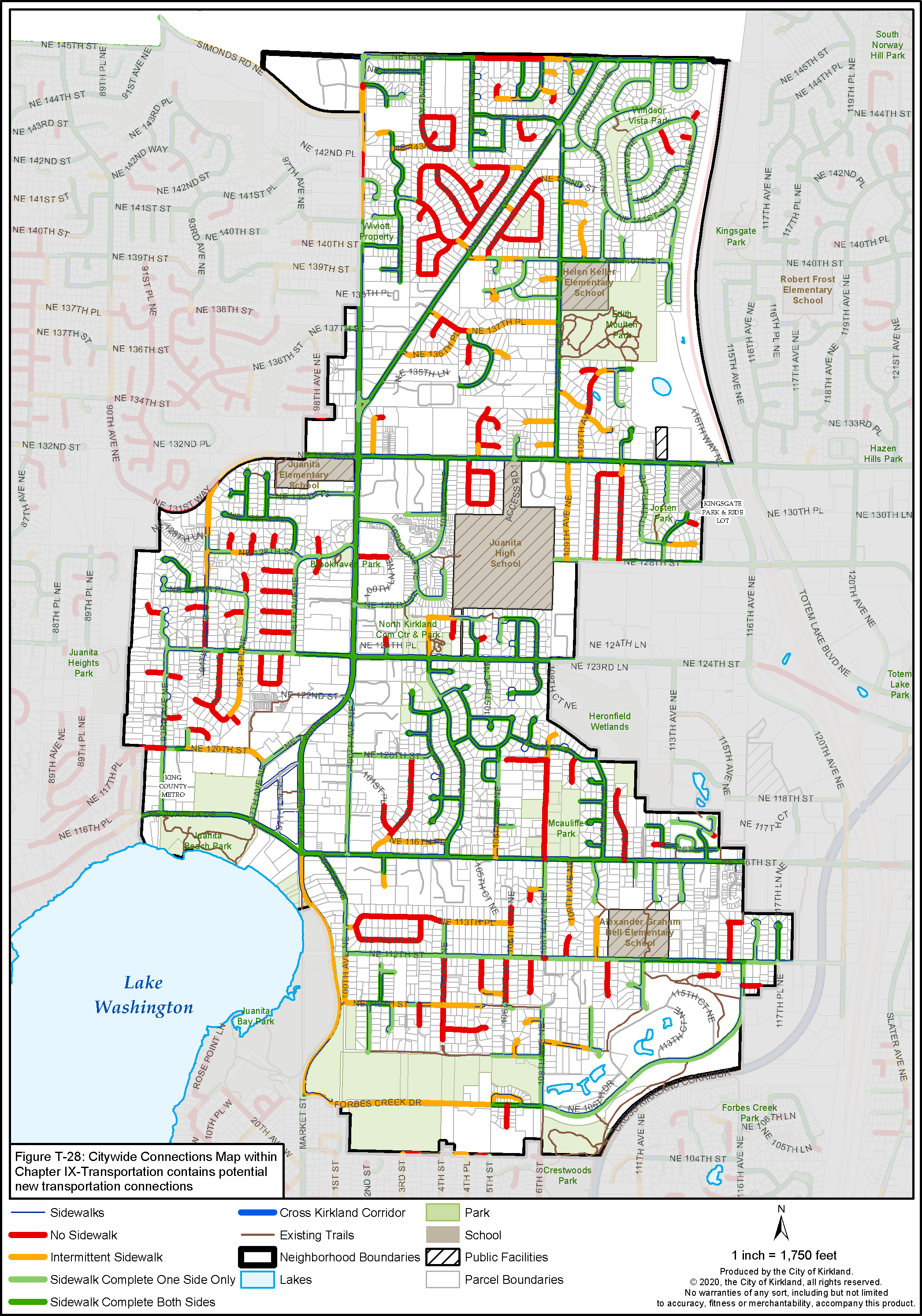
There are several areas in Juanita where improved pedestrian access would be highly desirable to the residents. Figure J-7 shows existing and desired pedestrian circulation. In the following areas, pedestrian easements should be acquired either through conditioning new development or major redevelopment:
(1) Along the Lake Washington shoreline from Juanita Bay Park to Juanita Beach Park.
(2) From 100th Avenue NE to 98th Avenue NE in both north and south neighborhood commercial districts (see also South Juanita Business District Section).
Figure J-6: Juanita Bicycle System
Figure J-7: Juanita Pedestrian System
(3) From 95th Place NE to the South Juanita Business District.
(4) Along Juanita Creek from Lake Washington to 100th Avenue NE and from 100th Avenue NE to the Totem Lake Business District if consistent with the Shoreline Area and Environment Chapters.
(5) From the Idylwood neighborhood to NE 124th Street.
(6) From Finn Hill (such as from Juanita Heights Park) through Juanita to Cross Kirkland Corridor.
(7) From the lakeshore to the Cross Kirkland Corridor by way of Forbes Creek Drive.
When reviewing development proposals, attention should be given to improving and establishing pedestrian connections from the developments to King County Metro stops and parks.


