6. LINK TO LAND USE
Goal T-5: Create a transportation system that is united with Kirkland’s land use plan.
Background
The Land Use chapter of the Comprehensive Plan provides a blueprint to complement Kirkland’s transportation network. “Transportation improvements” should truly be improvements to the community that help create a sense of place and reflect the character of Kirkland, not only improvements to mobility. Because the built environment influences travel behavior in so many ways, it’s often said that the best transportation plan is a good land use plan. This is demonstrated by the land use transportation connections illustrated in the following “smart growth Ds”:
Density: Higher densities shorten trip lengths, allow for more walking and biking, and support quality transit.
Diversity: A diverse neighborhood allows for easier trip linking and shortens distances between trips. It also promotes higher levels of walking and biking and allows for shared parking because of varied demand times amongst the uses.
Design: Good design is that which improves connectivity, encourages walking and biking, and reduces travel distance.
Destinations: Destination accessibility links travel purposes, shortens trips, and offers transportation options.
Distance to Transit: Close proximity to transit encourages its use, along with trip-linking and walking, and often creates accessible walking environments.
Development Scale: Appropriate development scale provides critical mass, increases local opportunities, and supports transit investment.
|
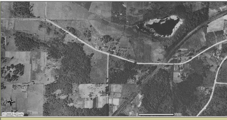
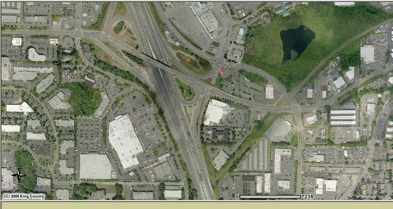
Two Views of Totem Lake |
|
|
|
|
|
The interchange at I-405 and NE 124th. In 1936 (top photo) the area was rural. A modest freeway interchange supported the suburban land of the mid 1960s. However, the fact that there was an interchange at all presented an opportunity to intensify the land use. As the land use changes increased, more capacity was added to the interchange which in turn spurred additional land use growth as shown in the bottom photo from 1997. This has left a legacy of auto-oriented land use and transportation facilities. |
The Land Use Transportation Connection is a two-way Connection. For example, increased density should be supported by an emphasis on transit, but at the same time, increased density should be planned in transit station area neighborhoods that are easy to serve by transit. Land use should coordinate with travel patterns as well. For example, currently in the mornings, there is more capacity northbound than southbound on parts of I-405, while the opposite is true in the afternoons. There may be land use choices in Kirkland that can take advantage of this capacity.
The Totem Lake Urban Center is transitioning from an auto oriented district to one that relies on a range of modes to support increased density. In particular, improved access to existing and planned transit hubs by walking and bicycling access should be a focus.
In neighborhoods where larger areas of single-family residences make it difficult to support high quality nearby transit, greenways, on-street bike lanes and sidewalks will offer options that help support a more livable community. Connections should focus on schools, parks, transit and commercial areas.
For employers in Kirkland to be competitive with those in other cities, their employees must be able to get to job sites quickly and easily and have adequate auto and bicycle parking.
Policy T-5.1: Focus on transportation system developments that expand and improve walkable neighborhoods.
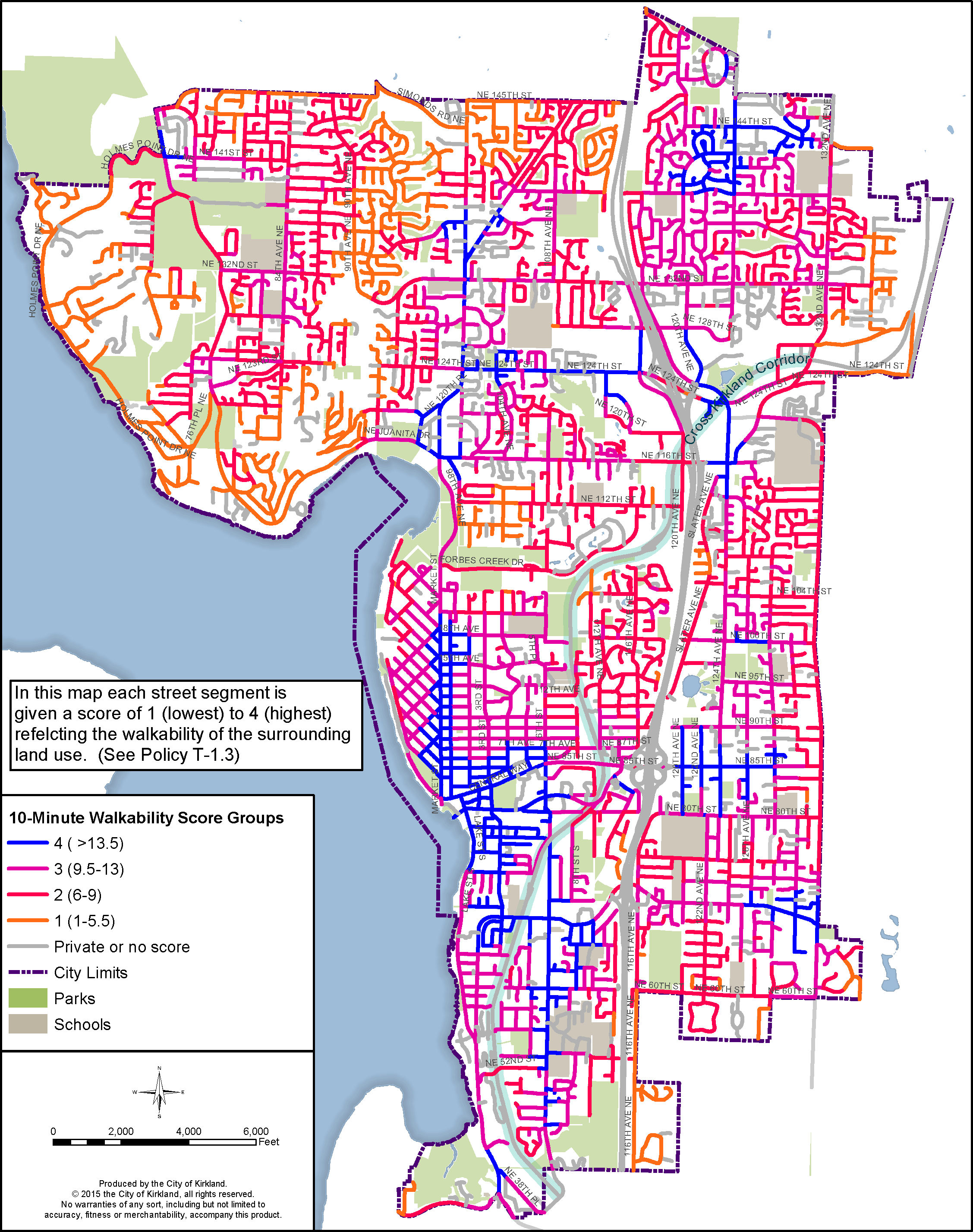
The prioritization of transportation improvements should be weighted toward those projects that expand or enhance connections within 10-minute neighborhoods (See Land Use Element of Comprehensive Plan). These could include building missing sidewalks within such neighborhoods or creating new trails that expand high quality walkable neighborhoods. (See Policy T-1.14.)
These areas should serve as transit station areas for local and regional transit service and should include high quality passenger environments. (See Policy T-1.4.)
Similarly, bicycling should be easy and comfortable for a wide range of users in and between 10-minute neighborhoods. (See Policy T-2.2, T-2.3.)
Based on the vision for the Comprehensive Plan, street improvements that add vehicle capacity should be designed to facilitate walking, biking and transit as well.
Policy T-5.2: Design streets in a manner that supports the land use plan and that supports the other goals and policies of the transportation element.
Street design should be guided by modern, urban-focused design guidelines such as those published by the National Association of City Transportation Officials Urban Street Design Guidelines and should include lighting, green spaces, street trees, wayfinding, street furniture, etc. Kirkland’s Zoning Code contains policies for street widths.
Street design should preserve existing significant trees and include new street trees and landscaping in the right-of-way to enhance the streetscape. Where significant trees are removed, they should be replaced or the loss should be otherwise mitigated. Street trees should be selected to minimize interference with other infrastructure and obstruction of public views from streets.
Policy T-5.3: Create a transportation network that supports economic development goals.
All transportation improvements should be evaluated in terms of their ability to support economic development. In addition to street improvement projects that build capacity for new commercial development, examples of projects that support economic development include bicycle parking improvements that bring bicycle customers to local businesses, transportation demand programs that make it easier for employees to get to work by a variety of modes, and creation of loading zones that expedite delivery of goods. (See the Economic Development Element of the Comprehensive Plan.) Benefits to economic development goals need to be balanced with impacts that may be created by pursuing these benefits.
Policy T-5.4: Develop transportation improvements tailored to commercial land use districts such as Totem Lake, Downtown and neighborhood business areas.
Fostering growth in Kirkland will require careful consideration of transportation facilities. This is particularly important in areas where traffic congestion occurs regularly and where increases in growth are planned.
Figure T-27: Walkability
The land use vision must not be lost in a quest to remove traffic congestion. For example, it should not be expected that street or intersection widening will be a primary tool in developing walkable, bikeable, livable neighborhood business areas, because this strategy would contradict the very land use vision it is intended to support. Instead, transportation facilities that allow safe and convenient travel by other modes should be promoted. This is not to suggest that cars will be abandoned, but rather to recognize that over the next 20 years, the City of Kirkland is pursuing a transportation approach consistent with its vision: a path that is different than the one laid out in previous plans.
Totem Lake and Downtown Kirkland should have primary connections to regional transit. Because of the size of the Totem Lake Urban Center it is important to make sure that regional transit effectively serves the entire center (see Policy T-7.1). Transit availability on the Cross Kirkland Corridor and I-405 will be particularly important.
New and reconfigured interchanges with I-405 will improve transportation for all modes and should be pursued (see Policy T-7.3). As discussed in the sections on walking and biking, the existing freeway interchanges are barriers and, in the case of NE 124th Street, severely constrain, the ability to move from one side of the Totem Lake Urban Center to the other. The space dedicated to the NE 124th Street interchange is substantial and if the interchange were designed more efficiently, valuable space could be freed up for more productive purposes. While reconstructing interchanges has large benefits, it also has high costs and long time frames.
Policy T-5.5: Require new development to mitigate site specific and system wide transportation impacts.
A sizable number of public improvements are built by the private sector as part of new development projects. Therefore, it is critical that policies, guidelines and practices used to plan, design and construct private improvements are consistent with Transportation Goals.
For individual development, the nature and timing of the mitigation should be based on the magnitude and proportionate share of the impacts and the timing of development. Mitigation may be necessary for impacts to intersections and local roadways, including pedestrian, bicycle and transit facilities. In addition, mitigation may be needed for site access to and from the local roadway system, including the connection or consolidation of driveways between parcels under separate ownership. The City maintains traffic impact guidelines to establish the basis for mitigation, its timing and its extent.
Throughout the City, private development is required, as part of the development process, to fund improvements needed to mitigate the impacts of their developments such as new streets, traffic signals and turn lanes.
To reduce the risk of crashes and/or to mitigate traffic congestion, it is sometimes necessary to limit access between roadways and driveways or to connect parking lots. This may come in the form of fewer driveways or limitations on the driveways that are allowed. In other cases private development will be required to provide turn lanes to ease access.
Private development is often required to dedicate land for construction of streets, sidewalks, bicycle facilities, through connections and other improvements needed to support transportation goals and policies.
Kirkland maintains a transportation demand planning model (the Bellevue-Kirkland-Redmond or BKR Model) in cooperation with the Cities of Redmond and Bellevue. This planning model should continue and the model should be improved to recognize advances in regional modeling such as better modeling of transit, biking and walking.
Policy T-5.6: Create a multi-modal transportation system that forms an interconnected network.
Traffic spread over a grid of streets balances and minimizes impacts across the network. Therefore, the fact that new connections may increase traffic volume on some existing streets is not a sufficient reason for rejecting such new connections.
Emergency response times are shorter and more reliable when responders have several routing options and new connections often provide these additional options.
Time saving and safe bicycle and pedestrian connections can be made by adding trail connections between cul-de-sacs.
|
Travel Forecasting |
|
The BKR model was originally developed in the early 1990s by City of Bellevue staff as a tool for transportation planning and concurrency monitoring. The model has been periodically updated over the years by Bellevue staff and consultants to incorporate changes in land uses and travel patterns. The last major overhaul to the model framework occurred in 2008, which incorporated travel pattern data from the PSRC’s 2006 household travel survey. |
|
The BKR model is a classic four-step model. For over half a century, four-step models have been the primary tool for estimating future travel demand for transportation planning projects in the United States. These models use a series of calculations that determine trip characteristics based on assumed land use patterns, socio-economic data and transportation system parameters. |
|
The 20-year land use assumptions, as described in the Land Use Element of the Comprehensive Plan, were input to the BKR model to perform travel modeling. The BKR model also assumes growth throughout the region, as forecast by PSRC. |
|
The travel modeling assumed the planned improvements along SR 520 and in the I-405 Master Plan, including tolling. The overall land uses in the BKR model were reasonably consistent with the land uses assumed in the modeling done for the WSDOT projects. Given the consistency with recent state efforts, the City did not undertake a separate study of freeway operations. Instead, the Comprehensive Plan includes policies to coordinate with the state to maintain mobility along state routes, which are vital transportation facilities connecting Kirkland with the rest of the region. |
Policy T-5.7: Develop a map of potential transportation connections that provides direction for property owners, developers, and City staff.
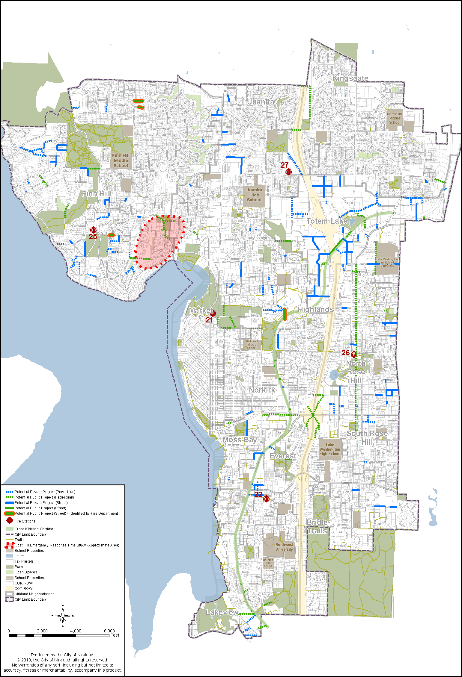
As a part of land development, new connections to the existing transportation system often are required. As part of the City’s Capital Improvement Plan, the City also may develop transportation connections. These typically are public streets for general circulation and/or connections for bicycles and pedestrians. In limited circumstances, they may be created for emergency access vehicles. Figure T-28 shows where potential multimodal transportation connections could be made.
Figure T-28: Citywide Transportation Connections
The locations of all the connections on the map are approximate, because they are intended to illustrate the desired connectivity between two areas, not necessarily the connection’s exact geographic placement. A connection identified on the citywide transportation connections map does not necessarily indicate a City commitment to create or cause the connection. This map does not necessarily include all future connections that could be initiated by the City or required by development.
While Figure T-28 is the adopted Citywide Transportation Connections Map, the City maintains an online map available at kirklandwa.maps.arcgis.com that provides additional details about each connection.


