4. Natural Environment
Goal L-2: Protect and enhance the natural environment in the Lakeview Neighborhood.
Natural Water Systems
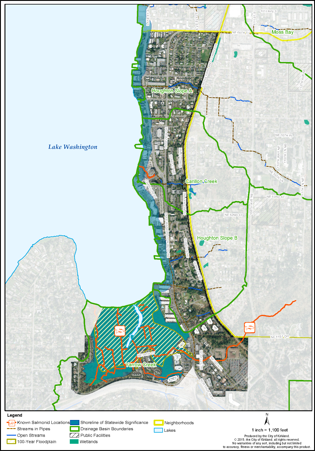
Policy L-2.1: Protect and improve water quality and promote fish passage by undertaking measures to protect Lake Washington, and the wetlands and streams in the Carillon Creek, Yarrow Creek and Houghton Slope basins.
Four drainage basins and associated creeks flow through Lakeview toward Lake Washington: Yarrow Creek, Houghton Slope A, Houghton Slope B, Carillon Creek and Yarrow Bay wetlands (See Figure L-2, Lakeview Sensitive Areas). These drainage systems provide important ecological functions such as flood and storm water conveyance, water quality, fish habitat, wildlife and riparian corridors, and open space benefits. Cutthroat trout inhabit Yarrow Creek. Cochran Springs Creek is considered a tributary to Yarrow Creek and also contains cutthroat trout, juvenile coho salmon and lamprey.
Where feasible, barriers within stream corridors should be removed to allow fish passage (such as through the SR 520 interchange, along Northup Way, and at the railroad crossing). Use of pesticides and fertilizer near stream and wetland areas is discouraged.
Policy L-2.2: Develop viewpoints and interpretive information around streams and wetlands if protection of the natural features and private property can be reasonably ensured.
Yarrow Bay wetlands function as a pristine natural wildlife reserve and water quality system filtering contaminants prior to discharge into Lake Washington. With improved access, the wetlands would also provide passive recreation and educational opportunities. Installation of viewpoints would improve visual access to the wetlands and Lake Washington if they could be constructed to protect the natural system and rights of private property owners.
Soils and Geology
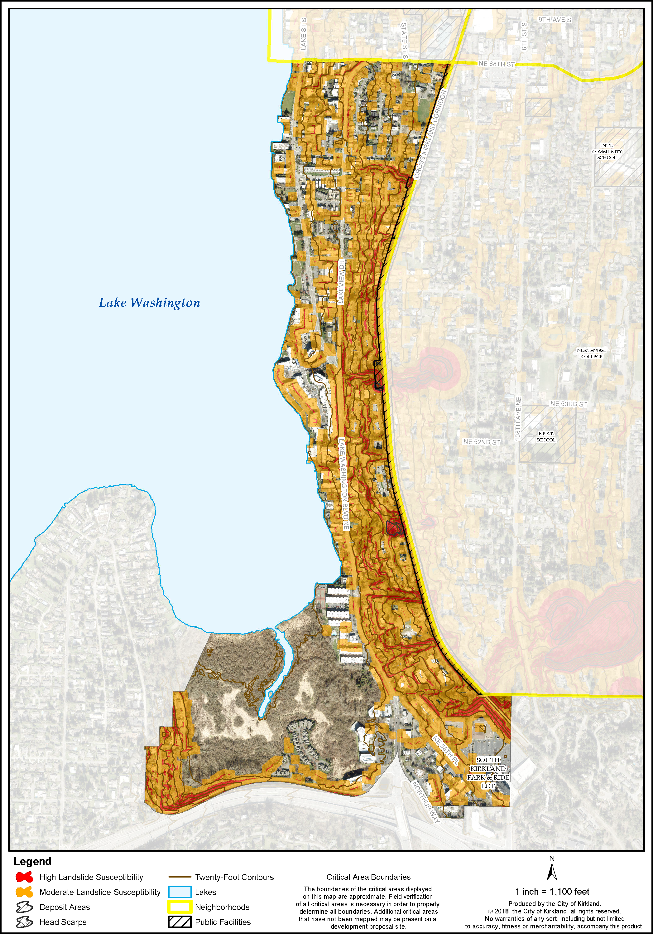
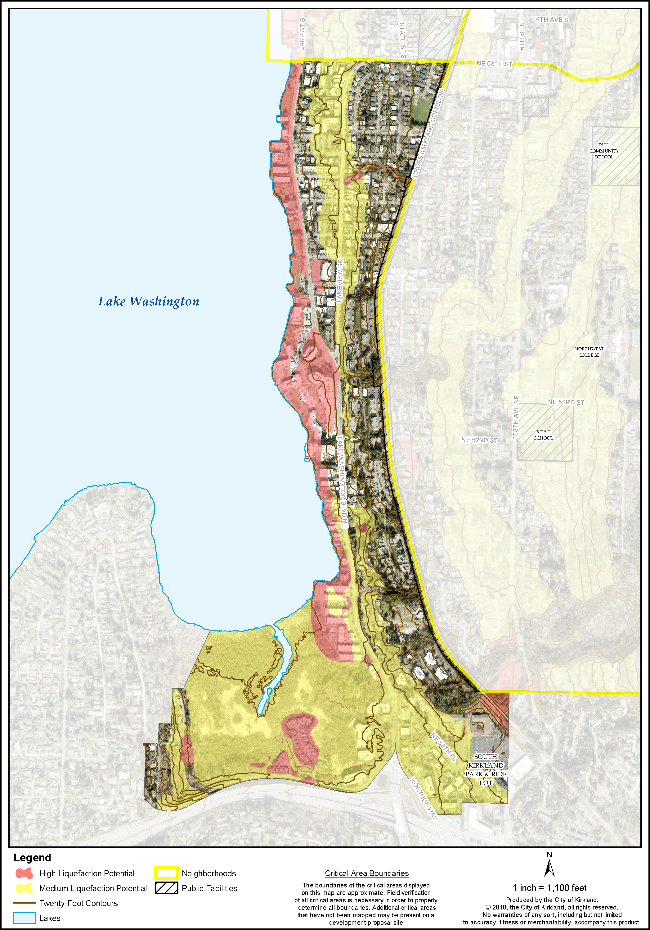
The Houghton and Yarrow Slopes contain soils susceptible to moderate to high landslide hazards particularly when wet or sliding as a result of earthquake activity (see Figures L-3a, Lakeview Landslide Susceptibility, and L-3b, Lakeview Liquefaction Potential).
Policy L-2.3: Manage development to protect potentially hazardous areas, such as landslide, erosion, and seismic areas.
Houghton Slope
The most sensitive portions of the Houghton Slope are generally south of NE 58th Street. The soil types there are prone to sliding and erosion, and the slopes are steep, averaging 15 percent with portions greater than 40 percent. There are several steep ravines which have a particularly high hazard of sliding because of the large amounts of groundwater in the slope causing artesian pressure and many small streams. The trees and other vegetation on the slope help to provide slope stability. They also provide significant aesthetic value because of the wooded slopes, particularly for those who enter the City from the south on Lake Washington Boulevard.
Houghton Slope north of NE 58th Street, although less sensitive than the slopes further south, also bears careful scrutiny. This area is mostly developed with low- and medium-density residential. Construction on or adjacent to these slopes may cause or be subject to land sliding, excessive erosion, and drainage or other problems associated with development on a slope.
Yarrow Slope
The Yarrow Slope, west and south of the Yarrow Bay Wetlands, has also been identified as having soils susceptible to moderate landslide hazards. Some landslides occurred in the early 1960s southward along the present location of SR 520. Nearby landslides, steep slopes, high water content, and peat deposits warrant additional geotechnical analysis to ensure slope stability. Locating structures on the site to minimize disruption to natural systems such as steep slopes, hillside streams and wetlands is preferred. Development on these slopes should consider the same development standards listed under the Houghton Slope land use sections below.
Some properties surrounding the Yarrow Bay Wetlands contain seismic hazard areas because the soil type is subject to risk of earthquake damage as a result of seismically induced settlement or soil liquefaction. Regulations governing development on geologically hazardous areas are located in the Kirkland Zoning Code.
Policy L-2.4: Protect wildlife throughout the neighborhood and encourage the creation of backyard sanctuaries for wildlife habitat.
The National Wildlife Federation has designated the City of Kirkland as a certified Community Wildlife Habitat. The Community Wildlife Habitat Program for the City began in the Central Houghton Neighborhood. Lakeview contains many wildlife corridors connecting parks in the Central Houghton neighborhood and along stream channels to Lake Washington and Yarrow Bay Wetlands. Residents are encouraged to improve wildlife habitat on their private property by planting native vegetation, and providing food, water, shelter and space for wildlife.
Figure L-2: Lakeview Wetlands, Streams, and Lakes
Figure L-3a: Lakeview Landslide Susceptibility
Figure L-3b: Lakeview Liquefaction Potential


