5. Land Use
Figure L-1 describes the land use designations throughout the Lakeview Neighborhood.
Residential
Goal L-3: Retain the residential character of the neighborhood while accommodating compatible infill development.
Policy L-3.1: Maintain Lakeview Terrace as a single-family residential area up to nine dwelling units per acre.
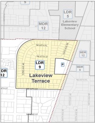
The single-family residential area of Lakeview Terrace, encircled by Lakeview Drive, NE 64th Street, and the railroad tracks, contains housing with some older structures. This area should be maintained as single-family at up to nine dwelling units per acre reflecting the existing small lots. The area should be protected from encroachment and adverse impacts of neighboring commercial and multifamily uses.
Houghton and Yarrow Slopes
There are geologic constraints and aesthetic attributes to consider for development on the Houghton and Yarrow Slopes.
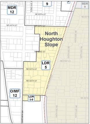
Policy L-3.2: Along the Houghton and Yarrow Slopes, establish development standards to protect property from landslides, seismic events and surface water runoff while allowing redevelopment compatible with existing development.
Policy L-3.3: Along the north portion of the Houghton Slope between NE 58th Street and NE 64th Street retain the existing single-family residential development at three to five dwelling units per acre.
The area bounded by Lakeview Drive, NE 64th Street, the railroad right-of-way, and approximately NE 58th Street falls within a Moderate Landslide Hazard slope area (see the Natural Environment section). All developments should be preceded by adequate slope stability investigations. The presence of an open stream, limited access, and existing small lot sizes impose limits on the feasible residential densities.
South Houghton Slope
The entire residential area south of NE 58th Street lies on the part of the Houghton Slope identified as containing High Landslide Hazard soils (see the Natural Environment section). Several underground springs, watercourses and forested ravines located along the hillside may contribute to slope instability.

The east portion of the slope is developed with the Yarrow Hill housing development. The majority of the lots in Planned Area 3C are under single ownership, are long and narrow, and have steep sloped driveways making vehicular and emergency access to Lake Washington Boulevard challenging. In many instances, the line of sight distances for automobiles entering and leaving the flow are generally too short to be safe. For these reasons consolidating driveways and limiting vehicular access points along Lake Washington Boulevard should be a priority in the design of new development.
Policy L-3.4: Residential development on the south Houghton slope should be limited. The Yarrow Hill Development should remain at three to four dwelling units per acre. The PLA 3C is appropriate for six dwelling units per acre with a minimum lot size of 5,000 square feet and subject to the development standards listed below.
Given the unique physical constraints of the west portion of the slope, the area should be treated as a planned area to allow for flexibility in site design, the location of structures and lot layout to protect steep slopes, existing water courses, and the retention of vegetation. Such techniques as aggregation of lots, smaller lots or clustering of units away from steep slopes should be encouraged.
Development should be subject to a public review process to ensure new development is consistent with the development standards described in Policy L-3.6 and compatible with surrounding existing residential uses. The size of the homes on the smaller lots should be limited by a reduced floor area ratio or other zoning requirements.
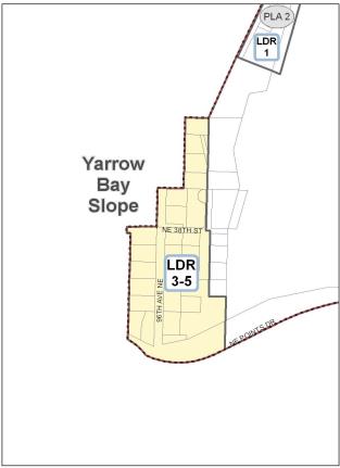
Policy L-3.5: Along the Yarrow slope allow residential density of three to five dwelling units per acre.
Along the slope west of the Yarrow Bay wetlands, because of the presence of geological, wetland and stream constraints found in the area, residential densities of three to five dwelling units per acre are appropriate. New development along the slope should also follow the development standards listed below for the Houghton and Yarrow slopes.
Policy L-3.6: Regulate development on Houghton and Yarrow slopes to avoid damage to life and property.
Development Standards for Houghton Slope and Yarrow Bay Slope
The Houghton and Yarrow slopes contain areas identified as potential landslide and erosion hazards. New development on these slopes should use the best management geotechnical practices specific to the site and design of project to minimize any potential hazards. New development should be subject to the following conditions:
1. A slope stability analysis should be prepared which evaluates the site and surrounding area to minimize damage to life and property. Specific structural designs and construction techniques to ensure long-term stability should be considered as part of the analysis. Within the PLA 3C area, as part of a development permit, the applicant’s geotechnical report should include a hazard assessment. The analysis and recommendations should be reviewed by a qualified geotechnical engineer selected and retained by the City at the applicant’s expense.
2. Hillsides with the steepest slopes and/or ravines may be required to be undisturbed in a natural condition and retained as permanent natural open space through the creation of a greenbelt easement or dedication.
3. A covenant which indemnifies and holds harmless the City for any damages resulting from slope instability should be required to be recorded on the property.
4. Lot coverage should be minimized to retain vegetation and watercourses.
5. Surface water runoff should be controlled at predevelopment levels.
6. Watercourses and wetlands should be retained in a natural state.
7. Vegetative cover should be retained to the maximum extent possible.
8. Flexibility in lot size and layout should be allowed through clustering of structures away from steep slopes and drainage courses and to preserve significant grouping of trees. Minimum lot size should be no less than 5,000 square feet (does not apply to Yarrow Bay slope).
9. For sites containing wetlands, the maximum density allowed with sensitive areas is prescribed in Chapter 90 KZC.
10. In the PLA 3C area, to provide flexibility in site design, one required side or rear yard may be zero feet (zero lot line) for the internal lot of a short plat or subdivision to allow for a two-unit attached home; provided, that:
a. Individual dwelling units are on separate lots, and
b. No more than two units may be in one building, and
c. Two-unit homes are designed to look like a detached single-family house using design techniques such as limiting the points of entry on each facade, pitched roofs and covered porches.
11. Encourage properties along Lake Washington Boulevard to consolidate existing driveways to reduce the number of vehicular access points (does not apply to Yarrow slope).
12. Sidewalks along the east side of Lake Washington Boulevard should be widened with new development and subdivisions to improve pedestrian circulation (does not apply to Yarrow slope).
13. The City has the ability to access and provide necessary emergency services.
Goal L-4: Allow alternative residential development options that are compatible with surrounding development.
Policy L-4.1: Allow a variety of development styles that provide housing choice in low density areas.
Providing housing options for a wide spectrum of households is an important objective to support and encourage. Alternative housing provides more housing choice to meet changing housing demographics, such as smaller households and an aging population. Allowing design innovations can help lower land development costs and improve affordability. Compatibility with the predominant detached single-family housing style in the neighborhood will determine the acceptance of housing alternatives. Alternative housing styles such as cottage, compact single-family, and common wall (attached) homes, accessory dwelling units, and clustered dwellings are appropriate options to serve a diverse population and changing household size and composition.
Policy L-4.2: Encourage diversity in the size of dwelling units by preserving and/or promoting small homes on small lots.
Diversity can be achieved by allowing properties to subdivide into lots that are smaller than the minimum lot size allowed in the zone if at least one of the lots contains a small home. This incentive encourages diversity, maintains neighborhood character, and provides more housing choice. Allowing smaller lots can also be an option for property containing environmentally sensitive areas.
Up to 50 percent of the single-family lots within a subdivision should be allowed to be smaller than the zoning normally allows if a small home is retained or built on the small lots. The lots containing the small homes should be no less than 5,000 square feet in the RS 7.2 zones and no less than 6,000 square feet in the RS 8.5 zones.
Medium Density Residential
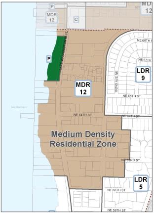
Policy L-4.3: In the north portion of the neighborhood west of Lakeview Drive, allow multifamily use at medium density 12 dwelling units per acre.
In the northern portion of the neighborhood west of Lakeview Drive, medium density residential is appropriate. Some parcels have multifamily development that was constructed under previous higher density development which is nonconforming under the current zoning. The Zoning Code contains the regulations governing nonconforming density.
Yarrow Bay Wetlands and Shoreline Areas
Policy L-4.4: In the upland area of Planned Area 2 adjacent to Points Drive allow multifamily development at a density of 10 to 12 dwelling units per acre. In the wetland portions of Planned Area 2 limit residential development.
Planned Area 2 is located adjacent to the Yarrow Bay wetlands. Any development in this area should maintain the functional integrity of the wetlands and the biologic functions of storage and cleansing of runoff waters (see Shoreline Area Chapter and Natural Environment section). In 1987, the majority of the Yarrow Bay wetlands were dedicated to the City of Kirkland to ensure protection. The wetlands have also been identified as an area subject to uneven settlement problems. For the land west of the Yarrow Bay wetlands and along the shoreline, densities should be extremely limited. Upland portions of PLA 2, outside the shoreline boundary and adjacent to or with direct access to Points Drive, have been developed as medium-density multifamily development (up to 12 dwelling units per acre).
Policy L-4.5: Allow multifamily, hotel/motel, and limited marina use within Planned Area 3B.
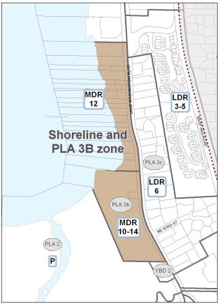
Planned Area 3B is fully developed with multifamily residential. Because of its adjacency to existing single-family and multifamily uses on the east and north, the development of office or other similar nonresidential uses in Subarea B would not be desirable. Use of existing multifamily units for overnight lodging, however, would be acceptable; provided, that the site development maintains its residential character and that accessory restaurants, retail, or similar uses are not allowed.
North of Yarrow Bay, existing development on the shoreline is primarily residential. As discussed in the Shoreline Area Chapter of this Comprehensive Plan, residential uses should continue to be permitted along the shoreline.
Policy L-4.6: Prohibit commercial uses along the shoreline south of Planned Area 15.
Commercial uses should not be permitted along the shoreline south of Planned Area 15 due to the residential character of the area as well as access and visibility limitations. North of Planned Area 15, commercial activities should be permitted if public access to and use of the shoreline is enhanced. Other standards for shoreline activities are specified in the Shoreline Master Program.
Planned Area 15
Planned Area 15 is comprised of Subarea A located west of Lake Washington Boulevard and Subarea B east of Lake Washington Boulevard and Lakeview Drive.
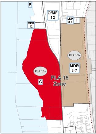
For many years, most of Subarea 15A was the site of the Lake Washington Shipyards, which ceased production in the late 1940s. The site was used as the Seattle Seahawks training facility until the late 1980s. The site is now developed as Carillon Point, a mixed-use commercial center containing office, retail, hotel, restaurant, marina and residential uses.
South of Carillon Point is the Yarrow Bay Marina containing over-water covered moorage facilities, dry dock boat storage, boat launch, boat sales and service, a pump-out facility and accessory office buildings. The marina has been in existence since the 1950s. In 2008, it was remodeled and added a shoreline public use area and public walkway connection to Carillon Point and the condominiums to the south. An office building exists on the parcel fronting Lake Washington Boulevard.
The majority of Subarea 15B is developed with medium to high density residential developed in conjunction with the Carillon Point Development to the west. Slopes in Subarea B are designated as containing moderate to high landslide hazard areas. Carillon Creek flows from Carillon Woods down the hillside through Carillon Point on its way to Lake Washington. With the development of Carillon Point the stream was enhanced with native plantings to improve fish habitat and serves as a natural amenity along the shoreline pedestrian walkway in Subarea A.
Goal L-5: Ensure development in PLA 15 continues to provide water oriented uses, visual and direct access to the lake, and maintains the natural characteristics and amenities of the stream and Houghton Slope.
Policy L-5.1: Within PLA 15A, provide a mix of uses with priority to water-dependent, water-related and water enjoyment uses located along the shoreline. Allow residential development at a density of 12 dwelling units per acre.
Subarea 15A west of Lake Washington Boulevard is developed with a mixture of uses. The City’s Shoreline regulations, Chapter 83 KZC, govern the types of uses and activities allowed in PLA 15A. Shoreline regulations designate the area as an Urban Mixed shoreline environment. Like the shoreline areas lying immediately to the north and south, residential development in Subarea A is allowed at a density of 12 dwelling units per acre.
Policy L-5.2: Retain water-dependent uses and the view corridor south of Carillon Point.
The marina development south of Carillon Point provides water-dependent uses, recreational activities and services. It incorporates a waterfront public use area and public shoreline pedestrian walkway connection to Carillon Point to the north and residential property to the south. A view corridor from Lake Washington Boulevard to the water should be maintained across the southern portion of both sites including maintaining the height of vegetation to not obscure the view of Lake Washington.
Goal L-6: Recognize and enhance Carillon Point as a mixed use employment center and tourism destination.
Carillon Point
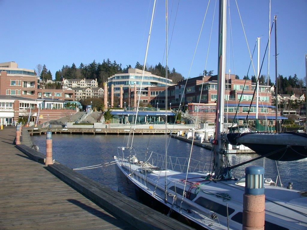
In the hierarchy of commercial areas in Kirkland, the Land Use Element designates Carillon Point as a business district with its mix of office, retail, restaurants, housing, hotel, service businesses and marina. Carillon Point serves not only as a regional employment center but visitors and local communities frequent the area as a waterfront tourism destination.
Policy L-6.1: Govern development and uses at Carillon Point by an approved Master Plan.
Carillon Point was developed under a master plan with an extensive public review and City approval process. Any future major change to the development should be reviewed to ensure Master Plan compliance.
The Master Plan and Zoning Code regulations for PLA 15A ensure that development will minimize impacts to existing uses in the vicinity including view obstruction, traffic volume and movement, noise and glare from uses of higher intensity, and compatibility of building scale. The Master Plan includes specific design guidelines for the site plan, circulation plan, and architectural design for the buildings.
The following is a summary of the key principles of the Master Plan to guide uses and development of the area (see KZC PLA 15A and 15B for more detail):
• Within the shoreline area water-dependent, water-related, and water-oriented commercial uses should be included, such as marinas, fueling and sewage pump-out facilities, and possibly tour boat operations, float plane service, passenger only ferry or water taxi facility, and public amenities access to piers for fishing, strolling or other pedestrian activities.
• Public access to and along the water’s edge and waterfront public use areas should be maintained including public access signs.
• Public improvements adjacent to Lake Washington Boulevard are also desirable, such as wide sidewalks.
• Visual access to Lake Washington from Lake Washington Boulevard should be maintained. To achieve greater visual access, building height, setback and view corridor requirements may be varied. Views from existing developments to the east should be protected.
• Manage parking on site to avoid impact to adjacent properties.
• Traffic impacts to Lake Washington Boulevard should be minimized including limiting vehicular access points.
• Subarea B has been fully developed as part of a master plan, including an allowed transfer of density from the PLA 15A Subarea.
Neighborhood Oriented Commercial, Professional Office and Multifamily
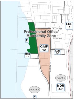
Goal L-7: Accommodate a mix of uses south of NE 60th Street between Lakeview Drive and Lake Washington Boulevard consistent with the development pattern in the neighborhood.
Policy L-7.1: South of NE 60th Street between Lakeview Drive and Lake Washington Boulevard NE, allow professional offices and medium-density residential use at 12 dwelling units per acre.
Allow small neighborhood oriented retail businesses; provided, that:
a. Front facades of buildings are not facing or oriented to Lakeview Drive.
b. Vehicular access is not directly from Lakeview Drive.
c. Internally lit signs are not located along Lakeview Drive and NE 60th St.
Medium-density residential uses, at a density of 12 dwelling units per acre, and professional offices should be considered the primary uses. Small, neighborhood oriented retail, convenience stores, coffee shops or similar uses that serve primarily the surrounding neighborhood are appropriate except where building front facades would face Lakeview Drive or direct vehicular access is provided along Lakeview Drive because of potential impacts to low density residential uses across the street. Internally lit sign faces should also not face Lakeview Drive. Appropriate uses are those that focus on local pedestrian traffic and will not result in spillover parking on neighborhood streets. Vehicle sales, service, and drive-through facilities should not be permitted in the PR zone.
Policy L-7.2: Provide a historic interpretive sign on the site of the old Houghton Post Office.
On the east side of Lake Washington Boulevard between NE 60th and NE 59th Streets, two older single-family house style buildings and a fast food restaurant exist. One of the older buildings was constructed in the early 1900s and was the early site of the Houghton Post Office. Both of the older buildings clearly do not meet zoning standards for building setbacks, parking, and other zoning nonconformances are likely. The other structure was built in the 1940s. The restaurant meets most or all of the current zoning standards for such uses. All three buildings are of a scale and design which are compatible with neighboring residential uses.
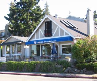
These parcels are appropriate for multifamily residential, office, and small, limited in size, and neighborhood oriented commercial uses discussed in Policy L-7.1. Continuation of existing office and commercial uses within the existing nonconforming structures should be allowed and reviewed administratively.
Because of the nonconforming conditions of both properties discussed above, some flexibility in applying normal zoning standards should be allowed provided certain development standards are met. If a change of use is proposed that requires more parking than the current use, the proposal should be evaluated for consistency with the following standards:
1. The use should provide a strong pedestrian orientation.
2. The number of required additional stalls for the new use should be determined based on the actual parking demand. New on-street parking on NE 60th Street may be counted toward a portion of the required parking with necessary improvements to the right-of-way provided at the developer’s expense.
3. New parking areas should be placed, screened, and buffered to mitigate impacts to nearby residential uses.
4. A historic interpretive sign should be erected on the site of the old Houghton Post Office.
5. Redevelopment of the properties should comply with all applicable zoning standards.
Policy L-7.3: Along neighborhood streets, parking associated with commercial development and waterfront parks should be monitored to avoid parking congestion.
Over time the area south of NE 60th Street has transitioned from single-family and industrial uses to primarily office and multifamily uses. Increased parking congestion along streets in the neighborhood from summer use of Houghton Beach Park and nearby businesses can also be a problem limiting access to surrounding businesses or the park. Therefore, parking on surrounding streets should be monitored to ensure access to parks and businesses.
Policy L-7.4: Limit commercial activities north of NE 64th Street east of Lake Washington Boulevard.
A convenience commercial grocery store located on Lake Washington Boulevard and NE 64th Street serves a localized need by providing limited grocery service to the surrounding residential neighborhood. Limited neighborhood commercial uses should be allowed to remain at this site and improvements should be encouraged to enhance its compatibility with surrounding residential uses and the scenic character of Lake Washington Boulevard. No further development of retail commercial facilities in this residential area should be permitted.
Yarrow Bay Business District
The Yarrow Bay Business District serves as an employment center containing corporate headquarters, large office complexes, restaurants, a motel, schools, and convenience services for local office workers and freeway travelers along SR 520. The Business District is divided into subareas primarily because of differences in topography and maximum building height.
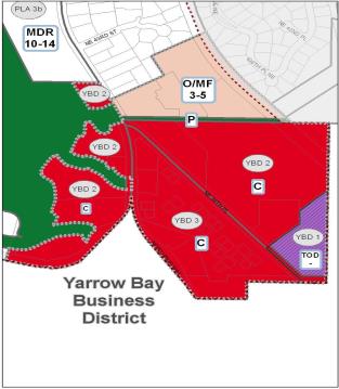
Goal L-8: Promote the vitality of the Yarrow Bay Business District as a coordinated, mixed use district.
The policies in this section are intended to support and strengthen the business district to evolve into a greater mix of retail, office, services, and housing to provide a more vibrant commercial district with greater pedestrian orientation and connections to transit facilities. Focus will be on integration of businesses and residents with a potential redevelopment of the area into a mixed use transit-oriented district.
Due to the availability of adequate public services, easy access to major arterials, the freeway, and the overall compatibility with adjacent land uses, the predominate use should be devoted to commercial activities. Retail uses may be included as part of office structures but not as stand-alone large structures. Incorporating residential uses with commercial development would strengthen the area into a 24-hour active community. All developments should include landscaping and other elements to enhance this interchange as a gateway to the City.
See also the Urban Design section regarding design policies for the Yarrow Bay Business District.
Yarrow Bay Business District 1 – YBD 1
The property containing the South Kirkland Park and Ride is about seven acres in size, with approximately equal portions of the site lying within the cities of Kirkland and Bellevue. The site is owned by King County, and currently developed as a park and ride with approximately 600 parking stalls and a transit facility. The site is generally level, but has a steep slope along the eastern and southeastern boundaries within the City of Bellevue section of the site. Tall trees and heavy vegetation are present within the hillside areas.
King County has identified the South Kirkland Park and Ride as a potential site for transit-oriented development (TOD) for several years. Affordable housing is generally included in King County TOD projects, and is anticipated to be a significant component of future residential development at the South Kirkland site. The City of Kirkland has identified transit-oriented development at the South Kirkland Park and Ride as a key affordable housing strategy. The City supports multifamily residential as the predominant use of the site in a transit-oriented development project, with a variety of other uses to be allowed as well.
The South Kirkland Park and Ride property may continue as a transit facility with the potential for office use. Alternatively, if the site is redeveloped with TOD, the principles discussed below should be used to guide development at the park and ride.
Policy L-8.1: Provide for affordable housing.
Ensure that transit-oriented development provides for mixed-income housing, including a minimum of 20 percent of total units to be affordable to low and/or moderate income households.
• Development should strive to achieve greater affordability for at least 20 percent of its units, with an additional 25 percent to be affordable to median income households, through the use of as many funding sources as are necessary.
Policy L-8.2: Ensure high quality site and building design.
Develop implementing regulations for coordinated development of the entire site.
• Establish standards for building height and mass that acknowledge site topography and existing vegetation as factors for consideration.
Implement design standards for YBD 1.
• Ensure that regulations support appropriate building scale and massing throughout the site, produce buildings that exhibit high quality design and incorporate pedestrian features and amenities that contribute to a livable urban village character for the TOD.
• Provide guidance for the streetscapes along NE 38th Place and 108th Avenue NE to ensure buildings do not turn their backs on the streets and development provides a welcoming and attractive presence at this gateway to Kirkland.
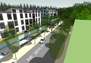
• Protect the vegetative buffers and significant trees along the site’s eastern and southeastern borders through development standards.
• Minimize the visual impacts of parking facilities from adjacent rights-of-way.
Foster the creation of a vibrant and desirable living environment through the use of high quality design, public amenities and open space.
Promote sustainable development through support of green building practices at the park and ride.
Policy L-8.3: Maximize effectiveness of transit-oriented development (TOD).
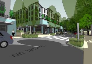
• Create the opportunity for Transit-Oriented Development (TOD) at the site through the development of standards and regulations that support necessary densities.
• Expand opportunities for retail development, incidental office development, and childcare facilities at the site to serve users of the park and ride, site residents and others.
• Provide opportunities for all types of users of the site to access the Cross Kirkland Corridor, however it is developed, along the eastern boundary of the Park and Ride site.
• Reduce the need for parking at the site through regulations that promote shared parking between uses, and incentives to support alternatives such as shared car services and electric cars.
• Mitigate traffic, visual, noise and other impacts from more intensive development of the Park and Ride to the surrounding street network and residential areas.
Policy L-8.4: Coordination with the City of Bellevue.
• Coordinate an approach for the review and approval of development proposals for the site with the City of Bellevue.
• Manage emergency services to the site through agreements with the City of Bellevue.
Yarrow Bay Business District 2 and 3 – YBD 2 and YBD 3
Policy L-8.5: In YBD 2 and YBD 3 encourage a mix of office, retail, hotels, restaurants, housing, and services and limit the size of freestanding retail establishments.
Development in YBD 2 and YBD 3 is appropriate for a mix of uses such as offices, specialty retail banks, hotel, motel, restaurants, schools or day care facilities, residential and grocery stores to serve offices and other employment nearby, or the freeway traveler. Individual freestanding retail establishments should be limited in size to less than 15,000 sq. ft. of gross floor area unless they are part of a mixed use project to avoid large scale, stand-alone retail uses more appropriate for other business districts. Drive-through facilities should not be permitted in the Yarrow Bay Business District because they discourage pedestrian-oriented development.
The clustering of development away from wetlands and streams is encouraged. Cochran Springs Creek requires protection. This area is the entrance to the City and, hence, the character of development is important. Because of the prominent location of the development as a southern gateway to the City, a gateway feature, art, superior landscaping, and pedestrian amenities should be provided along Lake Washington Boulevard (see Urban Design Section).
Policy L-8.6: Limit maximum building height to five stories in YBD 2 and YBD 3. Reduce building mass generally above the second floor with upper story setbacks, and vertical and horizontal modulation evaluated through the Design Review process.
Building height should be slightly lower in YBD 3 than YBD 2 to accentuate the rise in the topography of the district from west to east.
Policy L-8.7: At the southern end of the Houghton Slope professional offices or multifamily uses are allowed.
An existing office development is located at the south portion of the Houghton slope. The office land use designation should not extend further northward into the residential area on the southern end of the Houghton Slope. The offices provide a desirable transition to the residential area to the north and east. Accessory commercial uses are only permitted to serve the offices.
Policy L-8.8: Establish urban design standards for commercial and mixed use residential development in the Yarrow Bay Business District.
Design guidelines should be created to encourage attractive development in this gateway to the City. The design standards should encourage greater pedestrian orientation and pedestrian connections to other businesses, to the South Kirkland Park and Ride and other transportation facilities. Along the perimeter of the district, buildings should be stepped back vertically from the street and designed to be compatible with adjacent residential development.
Goal L-9: Provide transitions between residential uses and commercial uses.
Policy L-9.1: Minimize impacts of commercial development on residential areas and protect neighborhood character.
When locating more intensive commercial uses along the perimeter of commercial activity nodes, techniques should be used to minimize impacts on adjacent residential areas such as ensuring there is adequate parking on neighborhood streets for residents and businesses, minimizing noise in evening hours, and minimizing glare from commercial lighting. Regulating building height, building mass, building placement, and vehicular access and providing landscape buffers are effective transition techniques to reduce impacts of commercial uses on surrounding residential uses.


