


7. TRANSPORTATION
The original circulation pattern in Rose Hill was a grid, which should be perpetuated in the future because it promotes bike and pedestrian circulation, provides choice in travel routes, and distributes traffic along multiple routes. The goal of the transportation system is to build on the historic grid pattern of the neighborhood to foster transportation choice in the community, reduce dependence on private motor vehicles, and enhance safety.
New and improved bike facilities, the NE 70th Street/128th Avenue SE greenway, the Eastside Powerline trail and off-street trails connecting to activity centers, parks, business districts and schools will allow residents to leave their cars at home and reduce reliance on vehicle trips to meet daily local needs.
Streets
Rose Hill
Policy RH 64:
Manage traffic within the neighborhood to enhance neighborhood mobility and provide for more equitable distribution of traffic on neighborhood streets.
Policy RH 65:
Minimize multiple driveways on NE 70th Street, NE 85th Street, 124th Avenue NE, and 132nd Avenue NE when properties redevelop and encourage properties along these streets to consolidate their existing driveways and provide reciprocal shared vehicular access easements.
Policy RH 66:
Place neighborhood traffic control devices at appropriate locations, to discourage bypass traffic through the residential neighborhoods north and south of the NE 85th Street corridor.
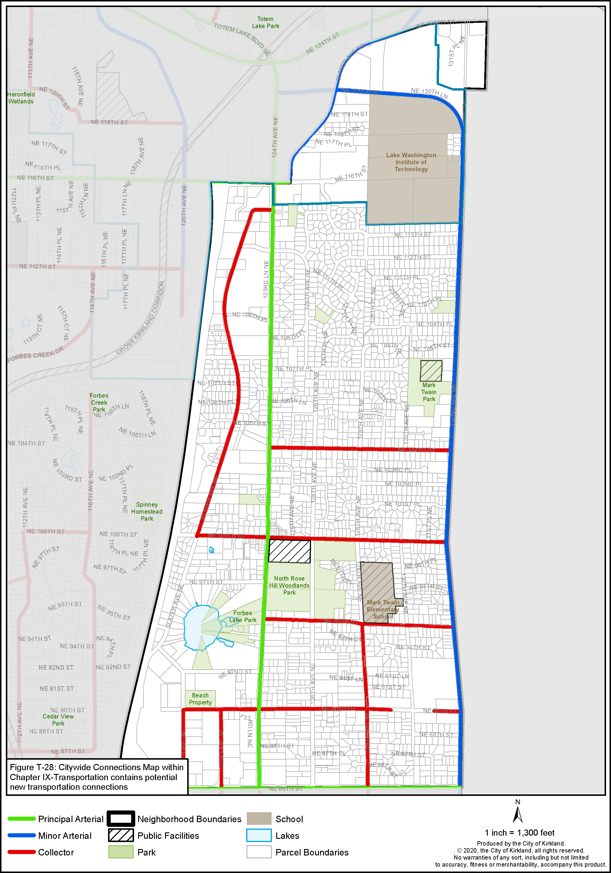
Figure RH-11: North Rose Hill Street Classifications
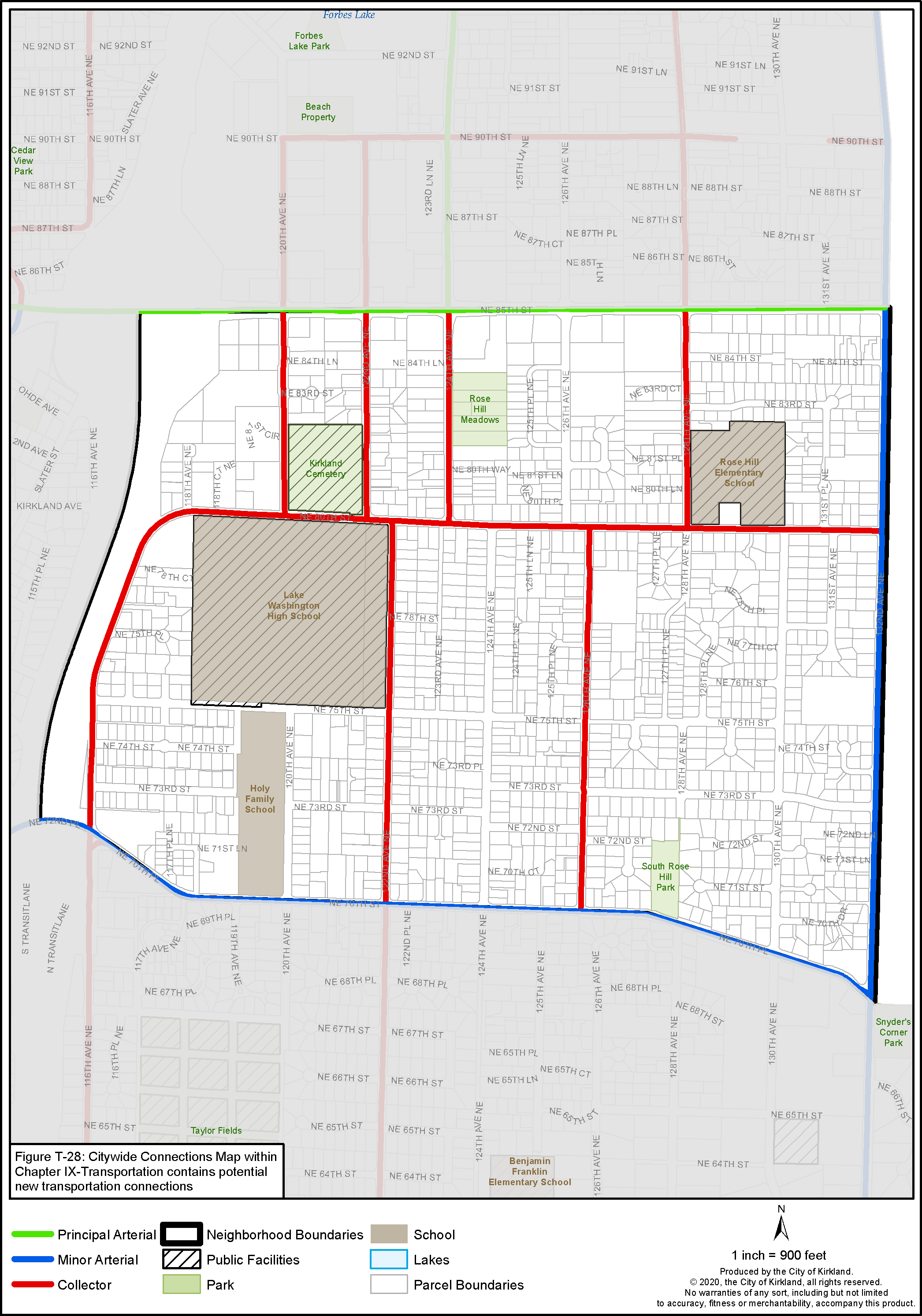
Figure RH-12: South Rose Hill Street Classifications
Policy RH 67:
Enhance the street network with the following improvements:
124th Avenue NE, north of NE 85th Street:
• Provide 80 feet of right-of-way width the length of 124th Avenue NE to accommodate a center turn lane and landscaped median islands, one through lane in each direction, one bike lane in each direction, intersection queue bypass lanes for transit, and a wide landscape strip, sidewalk, and street lights on both sides of the street. Dedication of an additional 10-foot minimum of right-of-way from each side of the street is necessary when development occurs. The location and design of landscape medians should be used to address safety and mobility in the corridor for all transportation users. Abutting business owners will be consulted prior to the installation of any new landscape medians to ensure that implementation results in minimal disruption to business operations.
• Provide sidewalks, curbs, gutters, landscape strips, and bike facilities along the entire length of 124th Avenue NE to improve pedestrian safety, especially between public facilities such as the Kirkland Boys and Girls Club and Woodlands Park.
• Provide crosswalk improvements, such as pedestrian signage, safety refuge islands, and signals, at key locations that serve existing and emerging activity centers.
• Prioritize traffic flow for transit by providing queue bypass lanes or signal preemption to encourage transit use.
132nd Avenue NE, north and south of NE 85th Street:
• Coordinate improvements to 132nd Avenue NE with the City of Redmond.
• While Kirkland’s City limits extend to the east side of 132nd Avenue NE this street is a mutual concern to both Kirkland and Redmond. Both jurisdictions should coordinate planning facilities that address common issues of concern.
• Provide sidewalks, curbs, gutters, landscape strips, bike facilities and street lighting along the entire length of 132nd Avenue NE.
This street provides direct access to both Mark Twain Park and the Lake Washington Institute of Technology. Completion of sidewalks to improve pedestrian safety, especially between public facilities, is a high priority.
• Provide a traffic signal and signalized crosswalk when engineering signal warrants are met at NE 100th Street.
Crosswalk improvements at other key locations that serve activity centers should also be installed as warranted.
• Prioritize traffic flow for transit by providing queue bypass lanes or signal preemption.
Queue bypass at locations where traffic queuing at intersections would otherwise slow buses will help to encourage transit use.
• Improve the appearance of and function of 132nd Avenue NE with the installation of landscape medians.
Pedestrian safety will be paramount in the design of the landscape medians with consideration for pedestrian visibility. The design of the median must also consider emergency vehicular access.
NE 116th Street:
• Install sidewalks, bike facilities, planter strips and consider other improvements such as landscape medians, high occupancy vehicle treatments, and on-street parking west of 124th Avenue NE.
These improvements are necessary to provide street definition, pedestrian safety, and access in support of the mixed-use residential/commercial development that is encouraged here.
116th Avenue NE:
• Install a sidewalk along the east side of 116th Avenue NE connecting the Houghton Park and Ride with the Lake Washington high school to increase safety.
North Rose Hill
Policy RH 68:
Discourage direct access to 124th and 132nd Avenues NE in North Rose Hill with new development to enhance safety and efficiency of circulation.
• If driveways to 124th or 132nd Avenues NE must be provided, separation of at least 300 feet between driveways should be required. New driveways should be located so that future development can meet this standard and/or use a shared driveway.
• Access easements to allow for shared access to 124th Avenue NE and/or interior connections to side streets should be provided.
• As access to side streets becomes available, driveways to 124th Avenue NE should be closed.
Rose Hill Business District
Policy RH 69:
Develop a multimodal transportation network for NE 85th Street and surrounding streets that provides safe and convenient facilities for transit, pedestrians, and bicycles, maintains vehicular traffic capacity, and supports existing and planned land uses in the Rose Hill Business District.
Policy RH 70:
Add east-west pedestrian pathways in the Rose Hill Business District as redevelopment occurs. When developing these pathways, retain existing significant trees where possible.
Policy RH 71:
Work with Sound Transit, King County Metro Transit and WSDOT, to maximize transit facilities that would improve the speed and reliability of bus operation on NE 85th Street and adjacent streets. Provide preferential treatments for buses at congested intersections. Install transit improvements at appropriate locations.
Pedestrian/Bicycle Circulation
Policy RH 72:
Encourage the use of nonmotorized transportation by providing appropriate facilities and infrastructure for pedestrians and bicyclists throughout the Rose Hill Neighborhood either when private development occurs or in some instances with public funding:
• Along school walk routes – highest priority.
• Between bus stops and residential development.
• Connecting to the planned Bus Rapid Transit Station at NE 85th Street on I-405.
• Connecting to the South Rose Hill Northeast 75th Street greenway and North Rose Hill 128th Avenue Northeast greenway.
• Connecting to activity areas, including parks, the Boys and Girls Club, Lake Washington Institute of Technology and Lake Washington High School.
• Connecting dead end streets to adjacent streets wherever new street connections are not required or feasible.
• Around a limited portion of Forbes Lake on City-owned park property and, where appropriate, across private property connecting to the Park.
• Various links between the Lake Washington Institute of Technology and surrounding residential development to the west between 132nd Avenue NE and Slater Avenue NE, and to the south.
• In NRH 3, in North Rose Hill, between the City open space to the east and 124th Avenue NE with redevelopment of the intervening private property.
• Under the Seattle City Light transmission line in cooperation with the utility and adjacent property owners. Public pedestrian and bicycle easements should be provided across private properties within the Seattle City Light easement, when development, redevelopment or platting occurs to complete the designated Eastside Powerline Corridor trail. See the PROS Plan for further details. This off-street north/south trail provides a safe pedestrian and bicycle link for the most part separated from the street system. Eventually this trail could link up to trail systems in adjoining jurisdictions.
• Connecting Juanita Bay to North Rose Hill Woodlands Park and eventually to the Sammamish Valley. Known as the Bay to Valley Trail, it would connect Lake Washington to North Rose Hill over the 100th Street Bridge across I-405, and along 100th Street and 132nd Avenue NE in Kirkland to the Puget Sound Energy Trail and Redmond Central Connector Trail in the Sammamish Valley via NE 97th St, NE 94th St and NE 93rd Ct in Redmond.
Policy RH 73:
Develop a new pedestrian and bicycle connection between Slater Avenue in the North Rose Hill Neighborhood and NE 80th Street in South Rose Hill. The route would connect to the existing NE 80th Street overpass which leads to downtown Kirkland, with the exact route to be determined in the context of the City’s Transportation Master Plan.
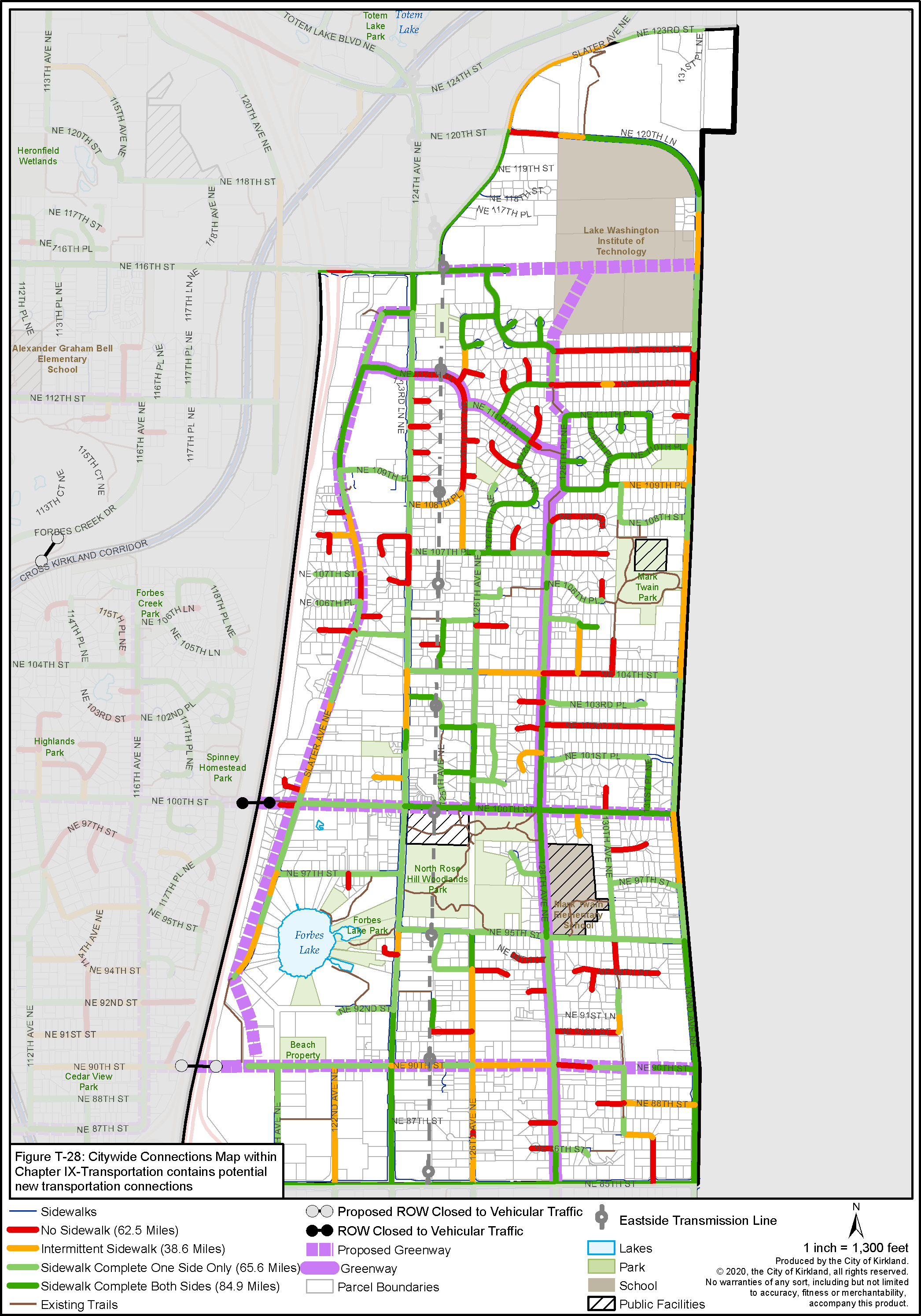
Figure RH-13: North Rose Hill Pedestrian System
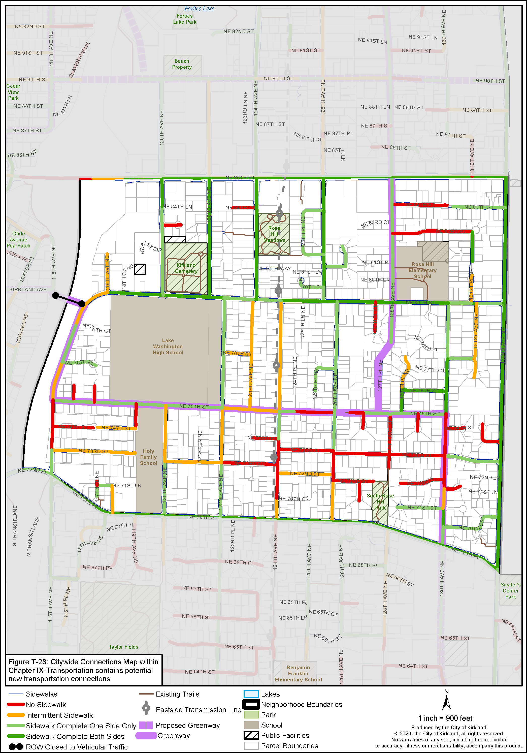
Figure RH-14: South Rose Hill Pedestrian System
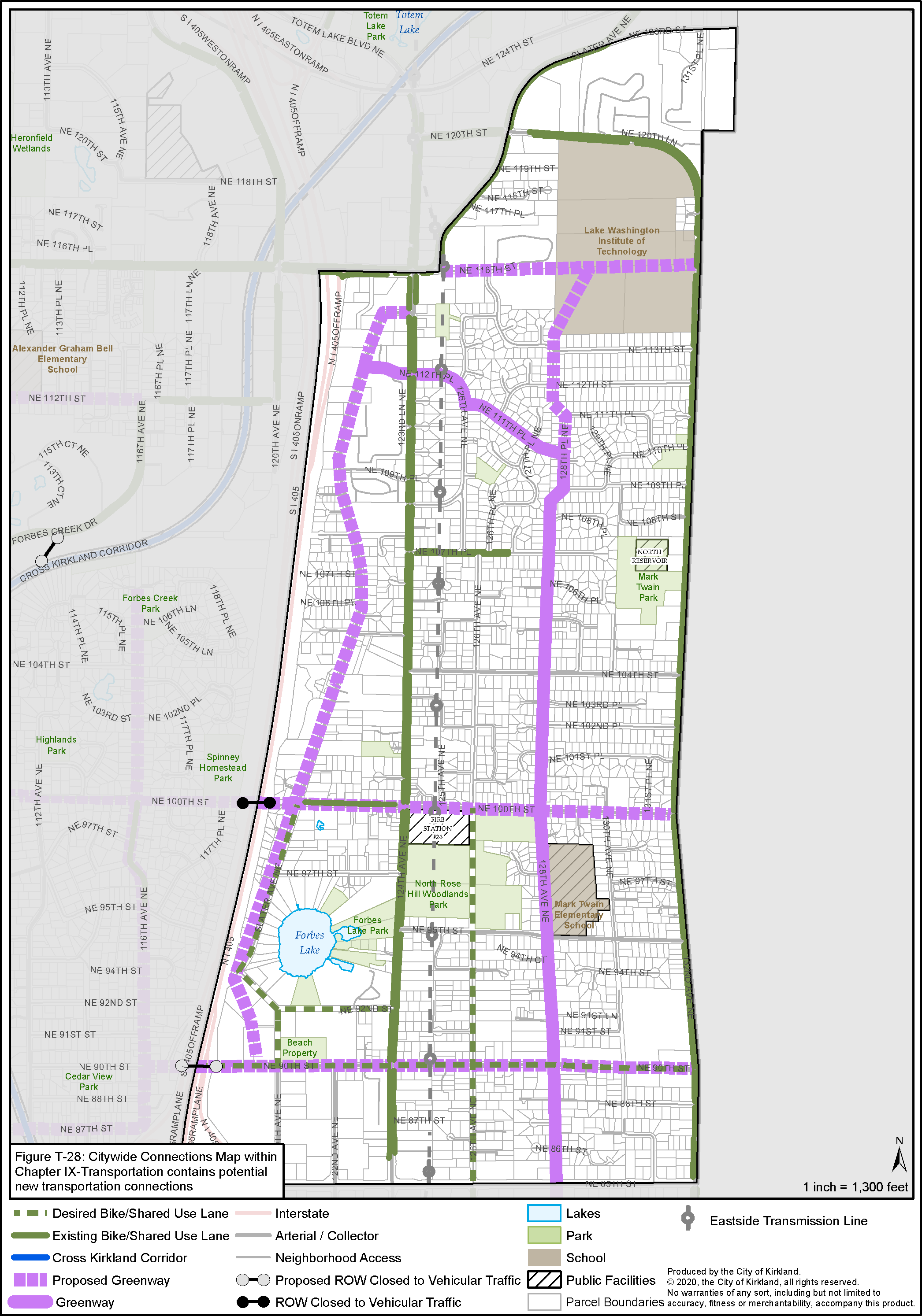
Figure RH-15: North Rose Hill Bicycle System
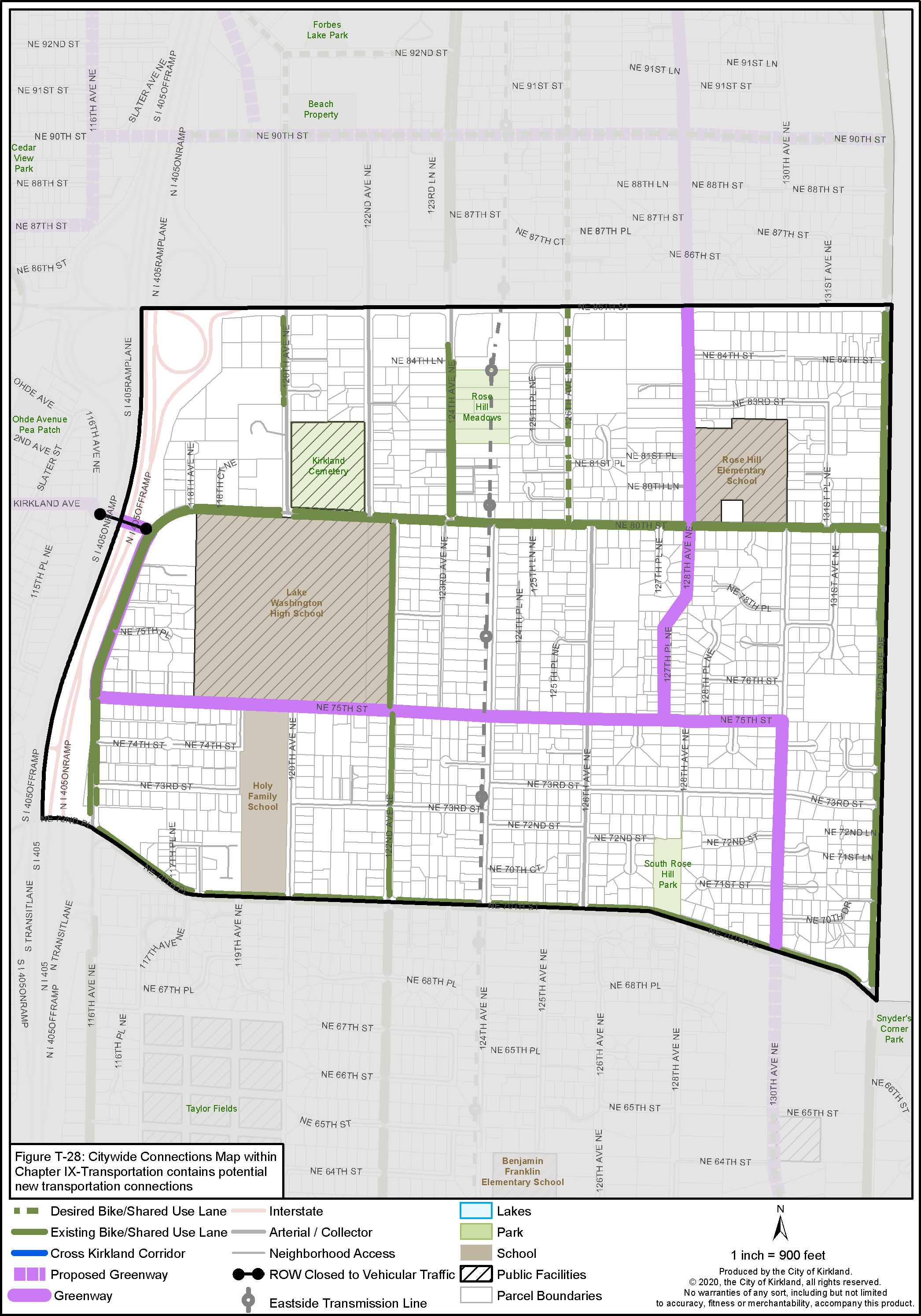
Figure RH-16: South Rose Hill Bicycle System