3. Land Use
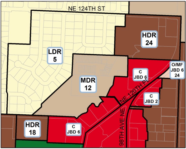
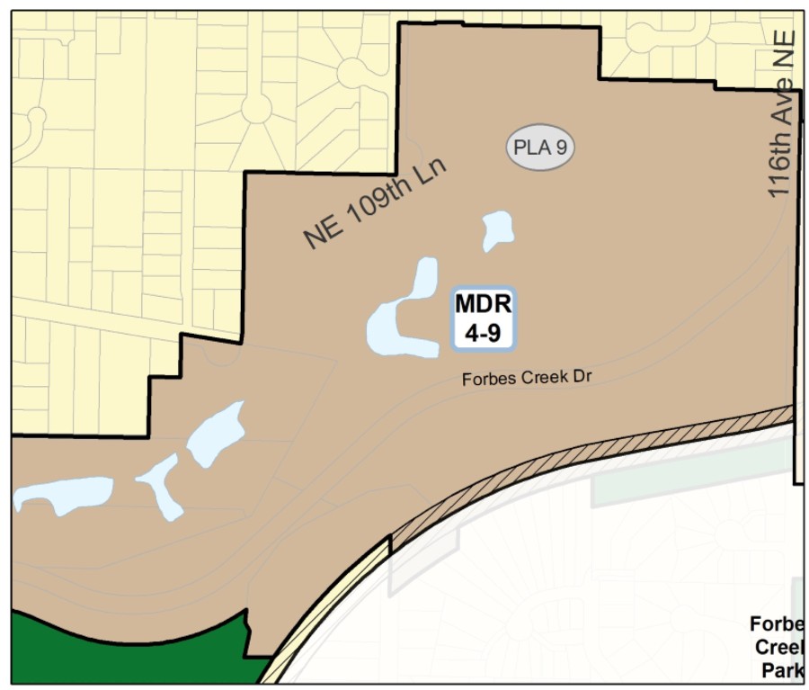
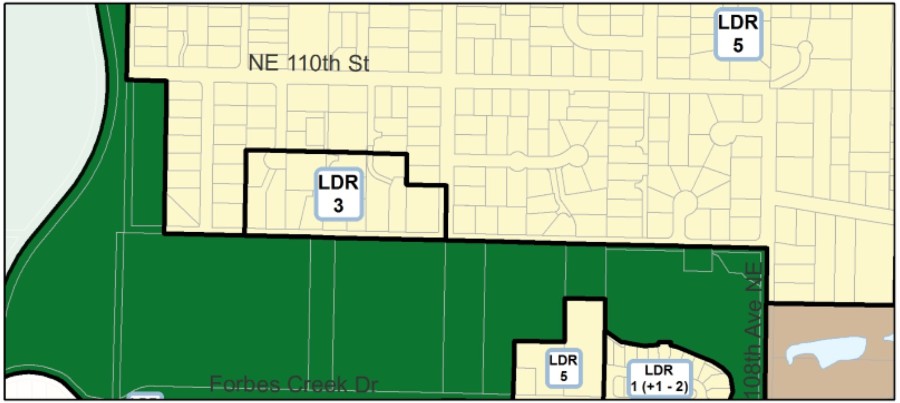
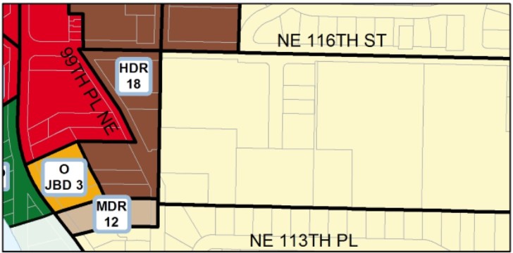
Specific land use designations for the Juanita Neighborhood are illustrated in Figure J-1. These designations are based on several factors including natural environment (see Natural Environment section), adjacent uses, traffic patterns, land use inventories, and other relevant concerns. For convenience, the following analysis of the land use areas are divided according to functional headings. The use of a particular piece of property is influenced by all applicable functional considerations (namely, natural and built environments, economic activities, open space, and public services).
Low Density Residential Areas
Most single-family residential areas in Juanita are designated at six units per acre.
Juanita is a varied neighborhood with significant and well-defined multifamily and single-family areas. The majority of the single-family residential areas in the neighborhood are designated for development at six units per acre (Figure J-1). There should be no encroachment of multifamily or commercial development into these low density areas except along the perimeter where properties are served by arterials, where transit, bike and pedestrian facilities are available. New development along collector or arterial streets should combine driveways whenever possible.
Forbes Creek Valley
Land use along Forbes Creek Drive is almost entirely of park and open space with some single-family detached homes, including a clustered small lot development. For seismic and flood hazard areas west of Planned Area 9 discussed in the Natural Environment Section, residential development should continue comparable to existing low densities at four to five dwelling units per acre.
Residential development on the unstable slope south of Forbes Creek Drive is to be limited to up to three dwelling units per acre subject to standards and development is permitted up to five units per acre if additional standards are met.
Figure J-1: Juanita Land Use
The natural and other development constraints discussed in the Natural Environment Section combine to limit residential densities to one to three dwelling units per acre. It is the cumulative effects resulting from full development at medium to high densities that are of greatest concern for increase in hazards of life and property. The wooded character of the slope should be maintained regardless of the allowed density.
The base density for residential development on the unstable slope south of Forbes Creek Dr. is three dwelling units per acre subject to the following standards:
(1) Soils analysis is required.
(2) Clustering of structures is encouraged.
(3) The maintenance of vegetative cover to the maximum extent feasible is required.
(4) Watercourses are to be retained in a natural state.
(5) Surface runoff is to be controlled at predevelopment levels.
(6) Points of access are to be minimized.
Four to five dwelling units per acre are permitted according to additional standards.
Residential densities on the unstable slope may be increased by an extra one to two dwelling units per acre (up to five dwelling units per acre) depending on the degree to which the development proposal conforms to the following standards:
(1) Soils and geologic analyses are required. The City will approve a qualified professional and establish reasonable study parameters. Analysis would cover the area of the site to be developed as well as adjacent sites.
(2) The developer indemnifies and holds the City harmless.
(3) Structures are clustered away from the steepest slopes and watercourses.
(4) The vegetative cover is maintained to the maximum extent possible.
(5) Watercourses are retained in a natural state.
(6) Surface runoff is controlled at predevelopment levels.
(7) Points of access to arterials are minimized.
(8) The City has the ability to provide the necessary emergency services.
(9) A minimum level of aggregation of land may be desirable in order to minimize adverse impacts.
(10) There is a public review process of the development proposal, such as a Planned Unit Development or Rezone review process.
Medium Density Residential Planned Area 9
Medium density residential, commercial recreation, and limited small offices are permitted in Planned Area 9 subject to standards.
Planned Area 9 was designated for several reasons including previous location of the Kirkland Sand and Gravel, locational characteristics, and challenges associated with future development. Forbes Creek flows through the area. Surrounding this area are residential uses on the slopes as well as immediately adjacent in the Valley. To the east is Par Mac industrial area in Totem Lake (see Figure J-1).
The property is developed as stacked dwelling units at a medium density residential at nine dwelling units per acre. A clubhouse or restaurant is permitted as part of a recreation facility. Small offices also may be permitted on a limited basis if well integrated into a predominantly residential or recreational facility.
Standards for commercial recreation uses in Planned Area 9 are listed.
The following standards apply to any commercial recreation facilities that would be permitted in this Planned Area:
(1) Noises produced from these activities are not to exceed levels normally found in a residential setting.
(2) Visual buffering towards residential uses will be required to reduce the impacts of structures or parking areas.
(3) Night lighting of outdoor areas should be limited and shielded in a manner that will not illuminate residential areas adjacent to the facility or elsewhere in the Valley.
North of NE 108th Street
Residential development may be limited on potentially unstable slopes north of NE 108th Street based on slope stability investigations.
Portions of the hillside north of NE 108th Street fall within a potentially hazardous slope area (see Figure J-3a). Residential densities of five dwelling units per acre are permitted except for lower areas, at three dwelling units per acre. All permitted developments should be preceded by adequate slope stability investigations. The presence of an open unnamed stream, limited access, and a large groundwater supply impose limits on the feasible residential densities.
South of NE 116th Street
Medium density clustered housing at up to seven units per acre is allowed on the south side of NE 116th Street subject to conditions.
A number of properties fronting on the south side of NE 116th Street have been developed with common wall or clustered housing at a single-family density. Low density development up to five units per acre is allowed, and slightly higher densities up to seven units per acre may be permitted subject to the following conditions:
(1) This added increment of density would only be allowed through a Planned Unit Development permit.
(2) Visual buffering by a landscaped setback (normally 40 feet) should separate the slightly higher density development from adjacent single-family residences.
(3) There is to be no direct access from individual dwelling units onto NE 116th Street. Access to NE 116th Street is to be limited to interior loop roads, cul-de-sacs, or similar streets. The added increment of density should not be available to properties where topographic conditions pose traffic hazards due to line-of-sight problems. Furthermore, access should be limited to NE 116th Street and not onto residential streets to the south.
(4) Pedestrian access through the development should be required to facilitate access to schools or other public destinations.
(5) Extensions of higher-density development should not penetrate into lower-density areas and should, therefore, be permitted only within a specified distance from NE 116th Street (to the approximate alignment of NE 114th Street).
(6) The height of structures should not exceed that of adjacent residential zones.
(7) Some common open space usable for a variety of activities should be included on site.
Southeast Slope of Finn Hill
Up to three units per acre should be permitted on the southeast slope of Finn Hill subject to additional standards.
The base density for residential development on the southeast slope of Finn Hill and the hillside northeast of NE 121st Place should be one unit per acre (see Figure J-1, Juanita Land Use). As discussed in the Natural Environment section, limitations on development are necessary in these areas to preserve the natural features and to minimize potential hazards. Development in these areas should be subject to the following standards:
(1) Preparation of geotechnical studies and slope stability analyses which address the site to be developed, as well as adjacent sites and the immediate drainage area;
(2) Recording of a covenant which indemnifies and holds the City harmless for any damage resulting from slope instability;
(3) Maintenance of maximum amount of vegetative cover and trees;
(4) Retention of watercourses in a natural state; and
(5) Establishment of Natural Greenbelt Protective Easements at a minimum around streams and in areas of greater than 40 percent slope.
Additional density up to three units per acre on the southeast slope of Finn Hill should be permitted subject to the following additional standards:
(6) Control of surface runoff at predevelopment levels;
(7) Limitation on the number of points of access;
(8) A minimum level of aggregation of land in order to minimize adverse impacts;
(9) Clustering of structures; and
(10) Public review of the development proposal such as a Planned Unit Development or Rezone.
Medium and High Density Residential
The densities shown in Figure J-1 for medium and high density residential areas either reflect the prevailing existing development levels or have standards to help protect sensitive areas, such as Juanita Creek, or to lessen traffic and parking problems in heavily congested areas, such as along 100th Avenue NE south of NE 124th or along 93rd Avenue NE.
General standards for multifamily development are as follows:
(1) The site design and placement of multifamily units should take advantage of the topography and existing vegetation to minimize the visual impacts of the new structures.
(2) Vegetative buffering (preferably with native, drought-tolerant plants) should be provided next to single-family areas.
(3) Public pedestrian easements should be provided to connect to schools or other public destinations. Convenient access to King County Metro stops should be provided. Medium- and high-density development around the business district should provide public pedestrian access to the commercial area.
(4) Vehicular access to multifamily projects should not negatively impact adjacent single-family areas. Vehicular access points should be combined and oriented to collector or arterial streets.
(5) Guest parking should be provided in all new developments and with any substantial remodels.
Medium density residential development is allowed north of NE 120th Street and west of 93rd Avenue NE at a density of 12 units per acre with up to 18 units per acre allowed if affordable housing is provided and the following standards are met.
Northeast 120th Street west of Juanita Business District JBD 6 is a natural boundary line for the medium to high-density residential to the south and low-density residential to the north. Two properties directly south of NE 120th Street and west of 93rd Avenue NE are suitable for medium-density residential at 12 – 18 units per acre, subject to the following standards:
(1) Dwelling units may be detached, attached or stacked.
(2) Future development should complement the adjacent single-family residential neighborhood. Building height, modulation, rooflines, separate exterior front entry doors to each unit and window treatments, and garages should reflect the design and character of single-family development as seen from the east, west or north. Each unit should have its own exterior front door. One common main door with interior corridor access to the units and/or a second level access with a common walkway to more than three units are not allowed. With the building permit application, the applicant shall provide the exterior building design showing compliance with the above elements for review by the Planning Official.
(3) Enclosed garages are encouraged. On-site surface parking or carports with peaked roofs should be screened by buildings or dense evergreen vegetation from the west and north.
(4) Buildings should be set back a minimum of 10 feet from the west property line adjoining the low-density residential development to the west.
(5) Evergreen trees (preferably with native, drought-tolerant trees) should be planted along the west property line to provide a buffer between the medium-density development and the adjacent single-family residence to the west.
(6) The property adjacent to 93rd Avenue NE should have vehicular access only from 93rd Avenue NE. If both properties are developed together at the same time, vehicular access should be combined and taken from 93rd Avenue NE and not from NE 120th Street to reduce traffic impacts for the single-family neighborhood to the north.
In addition, the properties may be developed at 18 units per acre if affordable housing is provided at one affordable unit for each three market rate housing units beyond the 12 units per acre.
Access to the high-density residential area south of NE 116th Street and west of 100th Avenue NE should be taken from NE 99th Place.
South of NE 116th Street and west of 100th Avenue NE is a high-density residential area. Although this area could receive access from NE 116th Street, 98th Avenue NE, or 99th Place NE, access should be limited to 99th Place NE because of limited sight distances, high traffic volumes along NE 116th Street and 98th Avenue NE and presence of streams and wetlands.
Other medium and high density areas north of NE 132nd Street are discussed.
Medium and high density residential uses located north of NE 132nd Street reflects land use designations and zoning at the time of annexation and functions as a transition between the mixed use commercial North Juanita Neighborhood Center and low density residential development. Medium density residential on the north and south side of Simonds Road reflects existing uses and densities at the time of annexation from King County and allows for clustering around steep slope areas.


