5. Natural Environment
Geologically Hazardous Areas
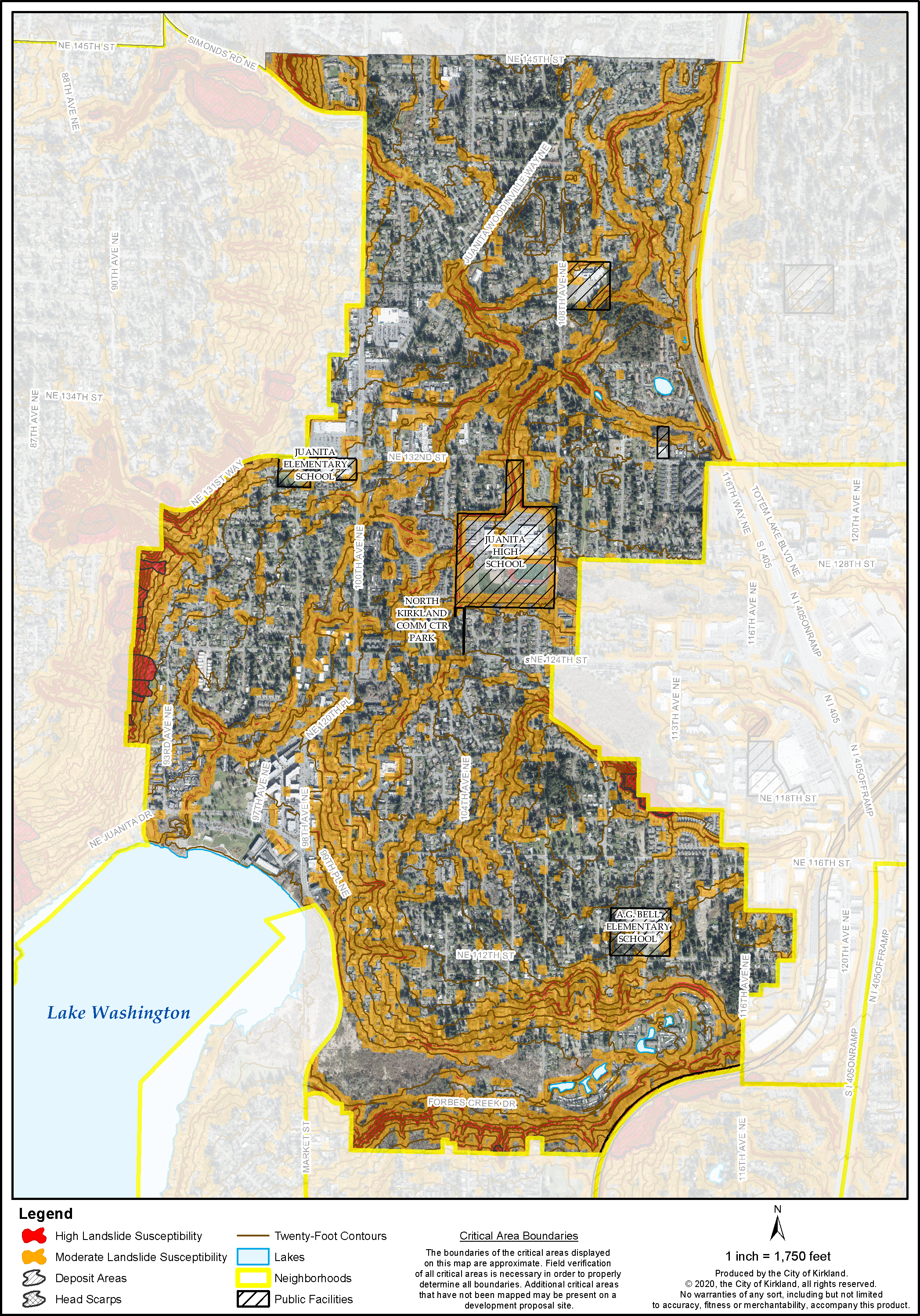
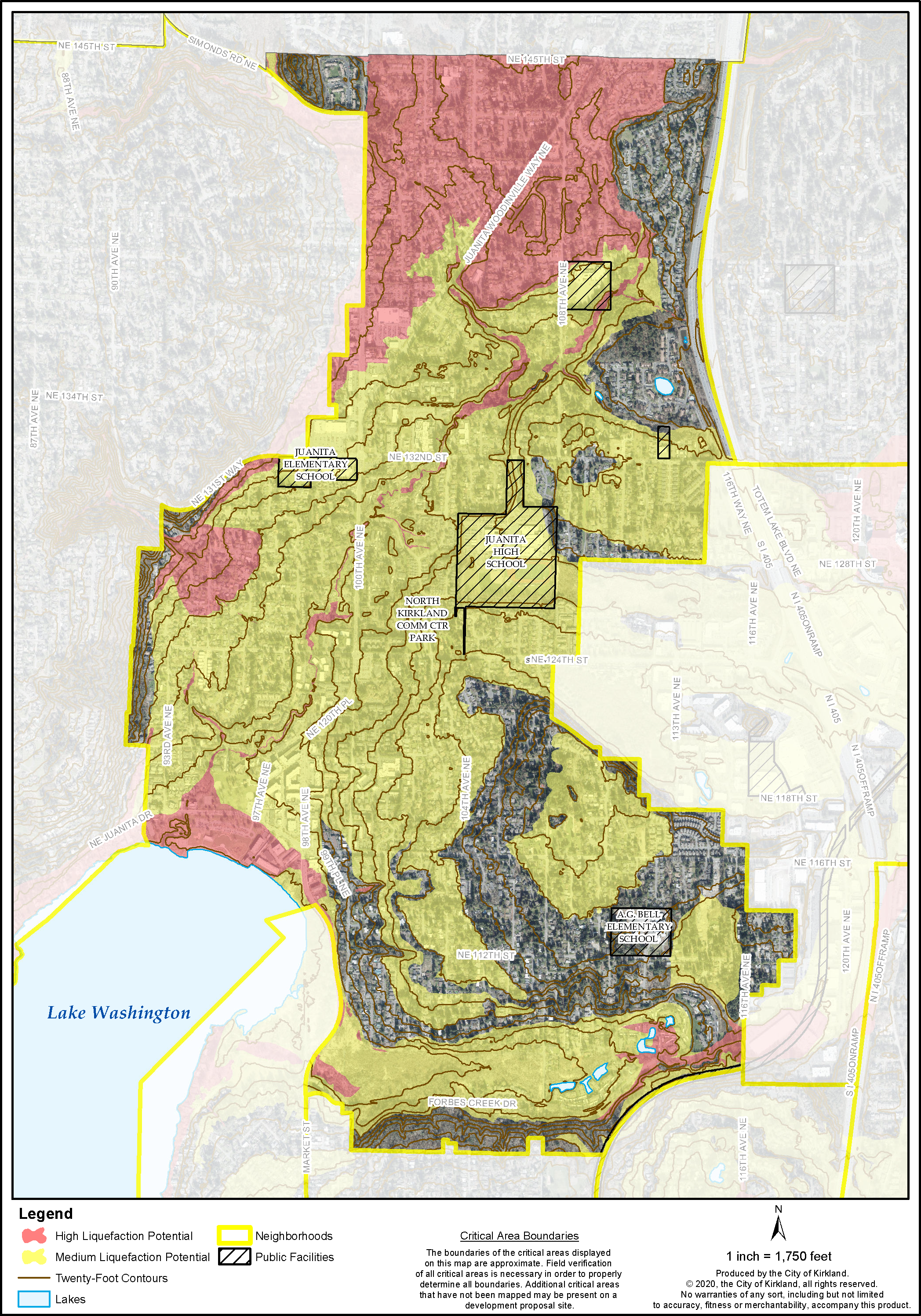
Juanita contains geologically hazardous soil areas shown on Figures J-3a and J-3b which include moderate and high landslide slopes and seismic hazard soils. Juanita also contains Juanita and Forbes Creeks within the South Juanita Slope, Juanita Creek and Forbes Creek drainage basins which are subject to risk of earthquake damage as a result of seismically induced settlement.
Primary areas at risk for moderate and high landslide include the southeast slope of Finn Hill, southwest of the Heronfield Wetlands, the South Juanita Slope on the east and west sides of 100th Avenue NE and along the south and north side of Forbes Creek Drive.
Much of the area south of Forbes Creek Drive lies on the part of the Juanita Slope identified as unstable. Slopes are steep at an average of 15 percent with some slopes up to 40 percent. There is a series of ravines which represent a particularly high hazard of sliding. There also is a considerable amount of groundwater in the slope causing artesian pressure and many small streams. Some creep and sloughing indicate active slope movement. The instability of the sand layer greatly increases when wet or modified. The presence of clay in the lower portions of the slope and saturated sand and gravel can also be contributing factors to landslides when wet. The slope will also be particularly prone to sliding in a time of a low-intensity earthquake. Limitations on development in geologically hazardous areas are described below and in the Environment Chapter.
The moderate and high landslide hazard slopes are expected to remain stable if left in a natural condition. Construction on or adjacent to these slopes may cause or be subject to landslides, excessive erosion, drainage, or other problems associated with development on a slope. Moderate and High Landslide Hazard steep slopes can be stabilized by preserving vegetative cover and following recommendations of slope stability analysis. Development should be regulated on these slopes to avoid or minimize damage to life and property. Therefore, a slope stability analysis should be required prior to development on these slopes as well as seismic hazard areas identified in Figures J-3a and J-3b.
It is important to retain significant trees because they can help to maintain the visual character of the neighborhood and help to protect unstable areas. Where possible, new development should be required to retain visually prominent stands of significant trees. Development in slope areas could result in extensive cut and fill and disturbance. The stability of the slope can be maintained by preserving vegetative cover. Maintenance of vegetative cover to the maximum extent feasible, in turn, helps to control the rate of surface water runoff which minimizes erosion and enhances water quality. See Environment Element and Utilities Element Chapters.
It should be noted that in slope areas, limitations on development are not due entirely to the existence of natural constraints. There may be additional reasons for limiting the type or density of development in slope areas, such as access, utility service, adjacent uses, and others.
Wetlands, Streams and Lakes
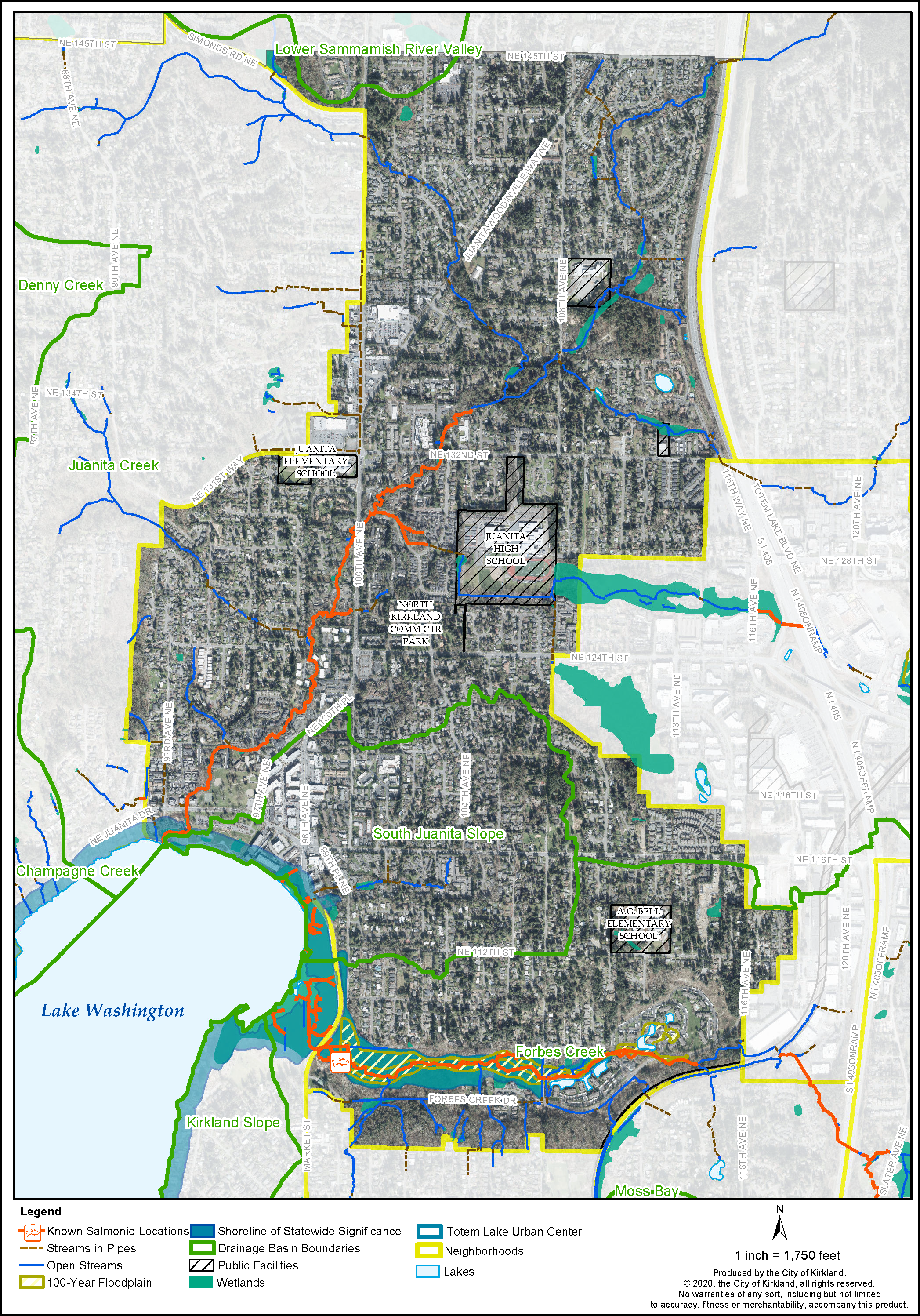
The Valley portion contains Forbes Creek and areas subject to uneven settlement and flooding due to wetlands and streams (see Figure J-4). Much of the Forbes Creek Valley area has been identified as a Flood Hazard and Seismic Hazard Area. Analysis of proposed developments should be required to mitigate problems associated with these factors. These flood areas are designated by the Federal Emergency Management Agency (FEMA). Federal law requires that flood insurance be obtained before any federally insured lending institutions may approve a loan for the development within an identified flood hazard zone. Also, Forbes Creek and associated stream corridor should be maintained in a natural condition to allow for natural drainage as well as possible salmon spawning (see Environment Element).
The Finn Hill slope and hillsides north and south of Juanita Bay and Forbes Creek Drive also contain streams and ravines which flow into the Juanita Creek and Forbes Creek drainage basins. In order to ensure these streams, ravines and slopes are maintained in a natural condition and minimize disturbance of unstable slopes, Natural Greenbelt Protective Easements should be created over them. Significant trees are prominent on these slopes from many vantages and if retained, they will help to reduce erosion on steep slopes.
The Juanita Creek drainage basin has suffered from development impacts over the years. The gradual filling of Juanita Bay with eroded sediments is one indication of this as is the decreased fish population. Therefore, stringent erosion control measures and substantial stream setbacks should be imposed on new development during and after construction. Native riparian vegetation should be planted in the setbacks to improve fish habitat and discourage activity near the banks.
Many of the minor creeks feeding Juanita Creek have been culverted which speeds flow and eliminates natural filtration. Streams should be removed from culverts whenever possible, and new culverting should be prohibited as regulated in KZC Chapters 83 and 90. The City has made improvements to portions of Juanita Creek to reduce erosion and restoration projects, such as at Juanita Beach Park. The City should continue efforts to rehabilitate Juanita Creek as a priority in its Capital Improvement Program. In addition, stream teams or volunteer citizen groups could work to enhance this resource.
Wetlands, like streams, should be protected with substantial buffers and erosion control measures. Public access through the Juanita Bay wetland and views of the lake should be provided if these actions will not impact the wetland. Public access should be developed along the Juanita Bay shoreline or through the wetland associated with the bay where appropriate and include interpretive centers. The interpretive centers should emphasize the biological importance of the wetland and the importance of protecting the resource. Measures should be taken to open significant public views of the lake whenever possible which will benefit the general public, provided the action will not negatively impact the wetland.
Figure J-3a: Juanita Landslide Susceptibility
Figure J-3b: Juanita Liquefaction Potential
Figure J-4: Juanita Wetlands, Streams, and Lakes
The portion of the Juanita Creek wetlands east of Juanita High School should be left in a natural state. Public access as described for the Juanita Bay wetlands should also be developed along this wetland.
The unnamed stream located east of the hillside above Juanita Bay (and associated wetlands along 98th Avenue NE) should be preserved and maintained in its natural state not only to provide storage and flow for natural runoff, but to provide natural amenities in the area.
The policies found in the Environment and Shoreline Area Chapters should be observed along with the policies described in this section when reviewing development proposals in Juanita to ensure the protection of the drainage, habitat, and aesthetic functions of the natural resources.


