7. TRANSPORTATION
STREETS
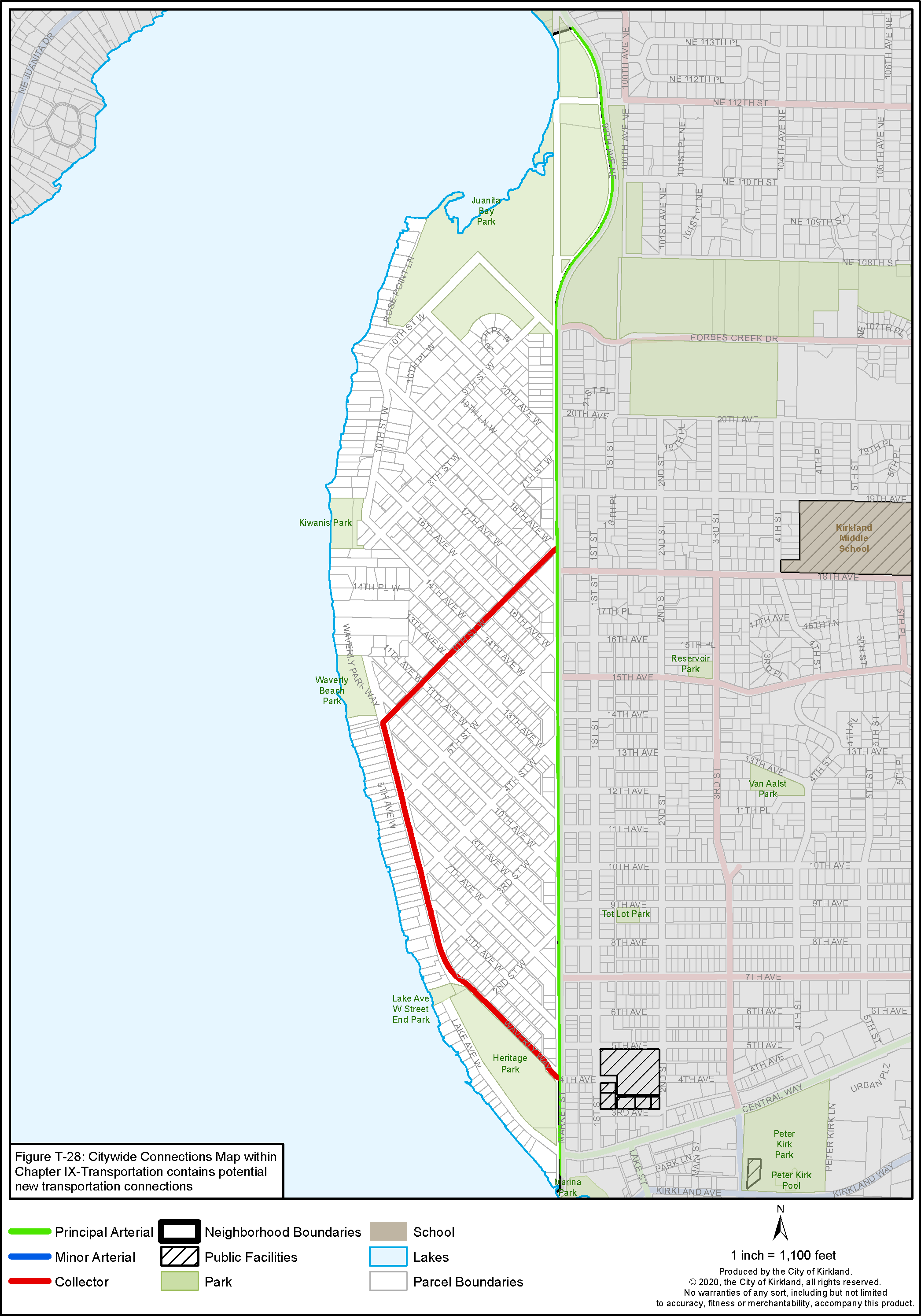
The street network in the Market Neighborhood is in a grid pattern. Maintenance of this grid promotes neighborhood mobility and more equitable distribution of traffic on neighborhood streets. The streets that compose this grid network consist of collector and local streets and alleys, with one principal arterial (Market Street) located at the eastern boundary. Streets are described below and shown on Figure M-5. Traffic is well distributed throughout the neighborhood by the existing street system.
Market Street is a principal arterial that is the most traveled route into and along the eastern border of the neighborhood. Most of Market Street is fully improved with one lane in each direction, and a series of left-turn pockets, curbs, gutters, sidewalks, a landscape strip, bike lanes and a priority bus lane at certain locations. A landscape median provides additional green space while controlling left-turn movements.
Collectors: Two streets within the grid network of the Market Neighborhood serve as neighborhood collectors. These streets connect the neighborhood to the arterial system and provide primary access to adjacent uses. Design standards for these streets call for two traffic lanes, a parking lane, curbs, gutters, sidewalks, and landscape strips. These collector streets are listed below and are also shown on Figure M-5.
6th Street West is a collector street from Waverly Way on the west side of the Market Neighborhood to Market Street on the east side. It provides access through the center of the neighborhood and provides access to Waverly Beach Park.
Waverly Way connects from 6th Street West to Market Street at the south end of the neighborhood. It provides north/south access along the western side of the Market Neighborhood. Waverly Way also provides access to Heritage Park and Waverly Beach Park. 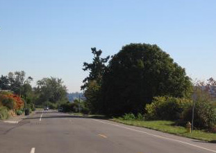
View down Waverly Way from 6th Street West
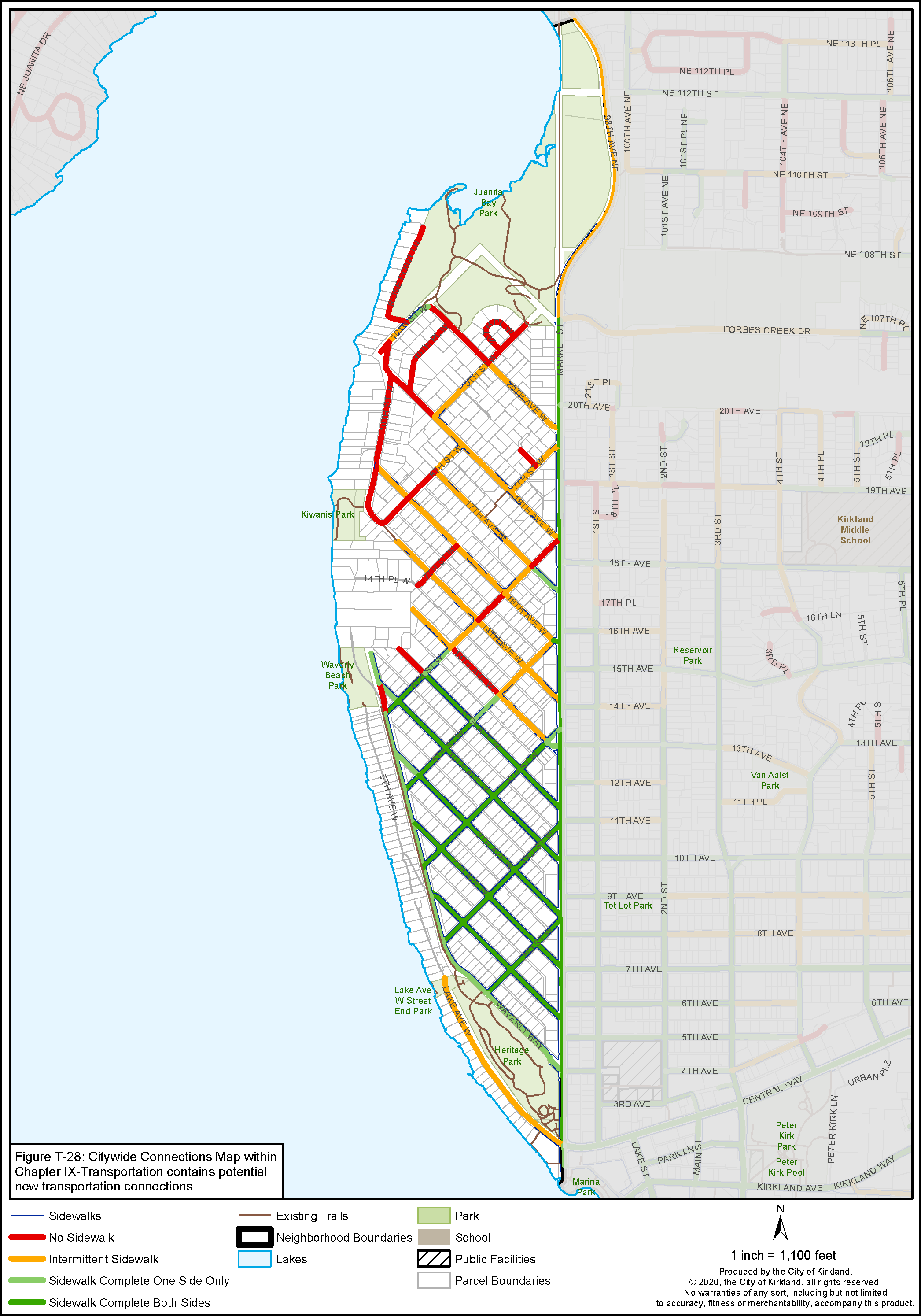
Neighborhood Access Streets: All of the streets not discussed above are classified as neighborhood access streets. These streets provide access to adjacent residences and connect to collectors or arterials. Full improvements on these streets typically include a travel way, on-street parking, curbs, gutters, sidewalks, and landscape strips. Full improvements do not exist on many of the neighborhood access streets in the Market Neighborhood, especially in the northern part of the neighborhood.
Alleys: Portions of the Market Neighborhood platted in the early part of the 20th century are served by mid-block alleys. Some alleys are paved and some are gravel.
Policy M-15:
Improve mobility for the Market Neighborhood.
Providing a safe circulation system within the neighborhood using all modes of travel (pedestrians, vehicles, bicycles) is an important objective for the neighborhood. The following policies aim to improve mobility for the Market Neighborhood.
Policy M-16:
Incorporate measures that will allow for safe access to Market Street during heavy traffic periods without disrupting the general flow of traffic.
Initial research indicates that such issues as pedestrian safety, sight distance problems, short acceleration lanes, speeding, lack of gaps for entry traffic, and transition to a 25 mph zone near the downtown all contribute to general traffic flow problems during peak commute hours. Possible solutions to these problems include: simplifying intersections; creating gaps in the traffic; and calming or slowing traffic on Market Street. Ongoing observation and study will be necessary to ensure that Market Street will continue to function as a principal arterial while providing efficient, safe access to the Market Neighborhood.
Policy M-17:
Maintain the street and alley grid in the Market Neighborhood while paving gravel alleys.
Alleys provide access and service routes for the lots they abut, while the streets provide circulation through the neighborhood. Utilizing alleys minimizes the number of curb cuts needed to serve abutting uses, thus minimizing conflicts with pedestrian and vehicular traffic on the streets. Gravel alleys should be paved per City standards as new infill development occurs to accommodate increased vehicle access and reduce dust.
Policy M-18:
Minimize cut-through traffic and speeding on neighborhood streets using neighborhood traffic control devices where appropriate.
Monitor and evaluate traffic patterns and volumes in the Market Neighborhood to minimize cut-through traffic and speeding, especially from Market Street. The evaluation should determine if additional strategies such as traffic calming, in cooperation with the Fire Department to accommodate emergency response needs and times, are needed. The community should be involved in this process as part of the City’s Neighborhood Traffic Control and Neighborhood Safety Program.
Policy M-19:
Ensure street safety as the neighborhood continues to grow.
As Kirkland and the Market Neighborhood have grown, vehicle, bicycle, and pedestrian traffic has increased and put pressure on the street network making it more difficult to comfortably accommodate all transportation modes. As the City grows, and streets become more crowded with multiple uses, it will be important to ensure intersections function sufficiently, sight lines are free from obstruction and traffic management is controlled to allow safe turns in multiple directions. Proactive attention to street safety is warranted.
PEDESTRIAN/BICYCLE CIRCULATION
The existing City of Kirkland Active Transportation Plan (ATP) identifies a network of existing bicycle facilities and planned improvements for a 10-year horizon and provides a process and criteria for identifying sidewalk and pedestrian infrastructure and how those might be prioritized. This plan is currently being updated and will provide guidelines for best practices, identify priorities, and a timeline for implementation. Those projects mapped in the Market Neighborhood Plan not shown in the ATP have been included in the data analysis that the City will be using to prioritize investments. Figures M-6 and M-7 show the planned bike and pedestrian system for the Market Neighborhood.
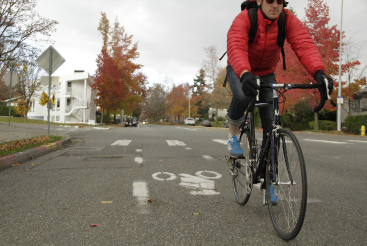
Bicycle Commuter on Market Street
City street standards require that all through streets have pedestrian improvements including curbs, gutters, landscape strips, street trees and sidewalks. Pedestrian improvements are usually installed as new development occurs. Sidewalks can also be installed through the capital improvement budget process in areas that have already been developed.
Sidewalks are a benefit when they are implemented in an effective way and on streets that are wide enough to accommodate them. In areas of Market where sidewalks were not historically installed, the current intermittent sidewalks make it a challenge for pedestrians. The requirement to install sidewalks during new house construction or renovation is not creating sidewalks quickly enough to eliminate the issues with intermittent sidewalks. In particular, for collector streets and school walk routes, the City should facilitate creating contiguous sidewalks on at least one side of the street.
It may well be that streets of insufficient width should not have sidewalks installed on both sides. Some streets, especially in the north section of the neighborhood, are not as wide as other neighborhood streets; as a result on-street parking on the narrower streets creates a single narrow lane of travel and makes it challenging for cars and cyclists to maneuver around the parked cars. However, narrower streets have proven to result in slower vehicle speeds which is also desired on neighborhood streets.
For narrower, unimproved neighborhood streets, a unified City plan for scaled-back improvements with sidewalks or parking on one side only could avoid having to negotiate these solutions one at a time as the issue arises during construction, and could create a safer, consistent look for the neighborhood.
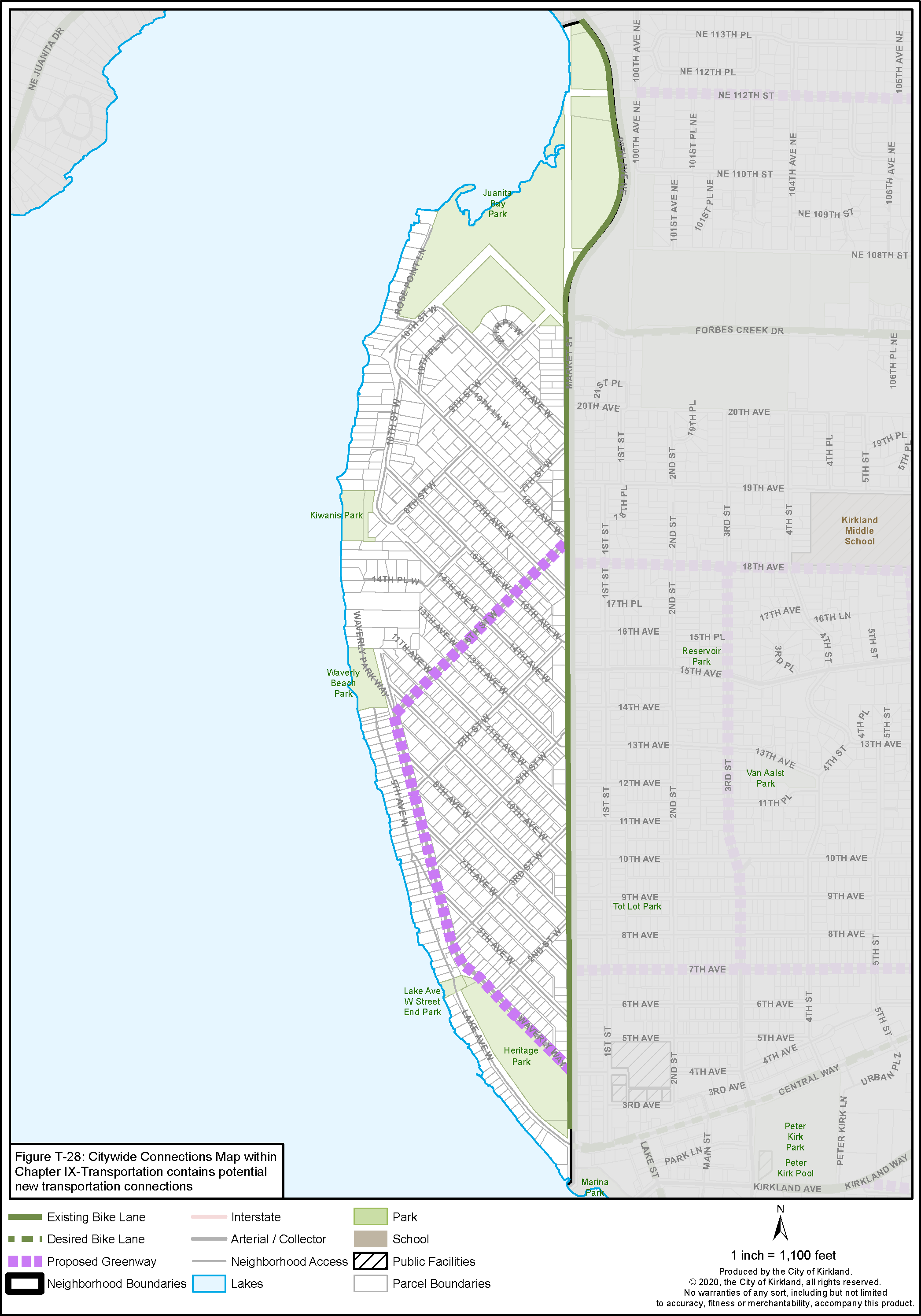
Bicycles are permitted on all City streets. Bike facilities include a designated bike lane with a painted line and a shared use path for bicycle and pedestrian use. The existing and desired bicycle routes identified for proposed bicycle improvements are shown in Figure M-7.
Policy M-20:
Enhance and maintain pedestrian and bicycle infrastructure within the Market Neighborhood, especially on designated school walk routes to adjacent neighborhoods.
The following routes have been identified by the neighborhood as priorities for implementation. The capital improvement budget process prioritizes when routes identified in the Active Transportation Plan (ATP) will receive funding for improvements.
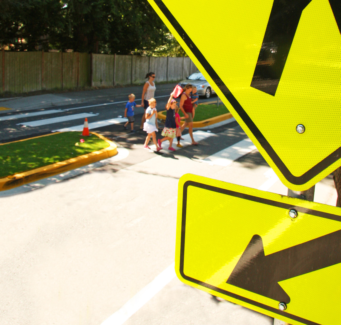
• 18th Avenue West – complete a pedestrian sidewalk along one side of 18th Avenue West to Market Street. This is a school walk route and should be prioritized.
• 9th Street West – between Market Street and 20th Street across Juanita Bay Park should be improved for both pedestrians and bicycles. The update of the Active Transportation Plan should evaluate adding this route to the planned bicycle network.
• Waverly Way – should be improved with a sidewalk on the west side of the street and a view station at the unopened street end at 4th Street West.
• 6th Street West – complete a pedestrian sidewalk between 11th Avenue West and Market Street and complete the proposed Neighborhood Greenway between Waverly and Market Street.
• Lake Avenue West Street End Park – complete a pedestrian pathway across Heritage Park from Waverly Way to the Lake Avenue West Street End Park.
The City’s capital improvement budget process can only address a small fraction of the improvements that appear in the various neighborhood and citywide plans. In considering the list above, the item that might be most productive and supportable is the proposed Greenway along 6th Street West and Waverly Way. As documented elsewhere, the Greenway concept is not a finished design prescription, and care would need to be taken to respect and augment the existing neighborhood character. Nonetheless, this particular Greenway could address a number of existing safety and alternative transportation concerns of the neighborhood, while at the same time contributing to the City’s broader transportation goals. As such, it is the sense of the neighborhood that this particular Greenway could be championed and supported as a priority above the others, if implemented through an inclusive process.
Figure M-5: Market Street Classifications
Figure M-6: Market Pedestrian System
Figure M-7: Market Bicycle System


