Chapter 9.26
Commercial, Industrial, and Public Facility Zoning Districts Revised 11/24
Sections:
9.26.020 Purposes of Commercial, Industrial, and Public Facility Zoning Districts
9.26.030 Commercial, Industrial, and Public Facility District Allowable Land Uses Revised 11/24
9.26.040 Commercial, Industrial, and Public Facility District Parcel and Density Standards
9.26.050 Commercial, Industrial, and Public Facility District Site Planning and Building Standards
9.26.060 Commercial, Industrial, and Public Facility District Land Use Limitations
9.26.070 Commercial, Industrial, and Public Facility Special Considerations
9.26.010 Purpose
This Chapter lists the land uses that may be allowed within the commercial, industrial, and public facility zoning districts established by Section 9.12.020 (Zoning Map and Zoning Districts), determines the type of planning permit/approval required for each use, and provides basic standards for site layout and building size.
9.26.020 Purposes of Commercial, Industrial, and Public Facility Zoning Districts
The purposes of the individual commercial zoning districts and the manner in which they are applied are as follows.
A. CC (Commercial - Central) district. The CC zoning district is applied to areas surrounding the Plaza, and is intended to accommodate retail, professional office, civic, hotel, theater, residential, and similar and compatible uses. The CC zoning district is consistent with and implements the Commercial Central land use classification of the General Plan.
B. CG (Commercial - General) district. The CG zoning district is applied to areas appropriate for a range of retail and service land uses that primarily serve local residents and businesses, including shops, personal and business services, and restaurants. Residential uses may also be accommodated as part of mixed use projects. The CG zoning district is consistent with the Commercial - General land use classification of the General Plan.
C. CM (Commercial - Mixed Use Center) district. The CM zoning district is applied to areas identified by General Plan policy LU-1d as the existing neighborhood centers of Westwood, Bayside, Sunny Brae, and Greenview, where additional retail, personal and business services, and other neighborhood-oriented commercial services are encouraged, and where substantial additions to the existing centers shall include residential units on upper floors or in separate buildings. The CM zoning district is consistent with and implements the Commercial - Mixed Use Center land use classification of the General Plan, and policy LU-1d.
D. CV (Commercial - Visitor Serving) district. The CV zoning district is applied to areas adjacent to highway interchanges that are appropriate for uses that primarily serve the traveling public, including lodging, restaurants, auto sales centers, service stations, convenience stores, and similar and compatible uses. The CV zoning district is consistent with the Commercial - Visitor Serving land use classification of the General Plan.
E. IL (Industrial - Limited) district. The IL zoning district is applied to areas appropriate for light and moderate impact manufacturing, and limited commercial uses. Residential uses may also be allowed where they are compatible with the nature of the production process, or the related sales of products made on the premises. The IL zoning district is consistent with the Industrial - Limited land use classification of the General Plan.
F. IG (Industrial - General) district. The IG zoning district is applied to areas appropriate for light, moderate impact, and high impact manufacturing, and limited commercial uses. The IG zoning district is consistent with the Industrial - General land use classification of the General Plan.
G. PF (Public Facility) district. The PF zoning district is applied to sites that are used or intended for use as various types of public facilities, and certain uses that may be privately owned, but are institutional in character. The PF zoning district is consistent with the Public Facility land use classification of the General Plan.
9.26.030 Commercial, Industrial, and Public Facility District Allowable Land Uses Revised 11/24
Table 2-10 identifies the uses of land allowed by this Land Use Code in the commercial, industrial, and public facility zoning districts, and the planning permit required to establish each use, in compliance with Section 9.20.030 (Allowable Land Uses and Permit Requirements).
Note: Where the last column in the table ("Specific Use Regulations") includes a section number, the regulations in the referenced section apply to the use. Provisions in other sections of this Land Use Code may also apply.
|
TABLE 2-10 Allowed Land Uses and Permit Requirements for Commercial, Industrial, and Public Facility Zoning Districts |
P MUP UP S — |
Permitted Use, Zoning Clearance required Minor Use Permit required Use Permit required (2) Permit determined by specific use regulations Use not allowed |
|||||||
|---|---|---|---|---|---|---|---|---|---|
|
LAND USE (1) |
PERMIT REQUIRED BY DISTRICT |
Specific Use Regulations |
|||||||
|
CC |
CG |
CV |
CM |
IL |
IG |
PF |
|||
|
INDUSTRY, MANUFACTURING & PROCESSING, WHOLESALING |
|||||||||
|
Agricultural cultivation - Cannabis |
UP(7) |
UP(7) |
— |
— |
UP/P |
UP/P |
— |
||
|
Agricultural processing - Very low impact |
— |
— |
— |
— |
P |
P |
— |
|
|
|
Agricultural processing - Low impact |
MUP(4) |
MUP(4) |
— |
— |
P |
P |
— |
|
|
|
Biodiesel production |
— |
— |
— |
— |
UP |
UP |
— |
|
|
|
Composting |
— |
— |
— |
— |
MUP |
MUP |
— |
|
|
|
Construction contractors |
— |
— |
— |
— |
P |
P |
— |
|
|
|
Furniture and fixtures manufacturing, cabinet shop |
— |
UP |
— |
— |
P |
P |
— |
|
|
|
Laboratory - Medical, analytical, R&D |
— |
P(8) |
— |
— |
P(8) |
P(8) |
— |
|
|
|
Laundry, dry cleaning plant |
— |
UP |
— |
UP |
P |
P |
— |
|
|
|
Manufacturing/processing - Low impact |
MUP(4) |
MUP(4) |
— |
— |
P |
P |
— |
|
|
|
Manufacturing/processing - Moderate impact |
— |
— |
— |
— |
MUP |
MUP |
— |
|
|
|
Manufacturing/processing - High impact |
— |
— |
— |
— |
— |
UP |
— |
|
|
|
Media production |
P |
P |
— |
— |
P |
P |
— |
|
|
|
Printing and publishing |
P |
P |
— |
— |
P |
P |
— |
|
|
|
Recycling - Processing facility |
— |
— |
— |
— |
MUP |
P |
— |
||
|
Recycling - Reverse vending machines |
— |
P |
P |
— |
P |
P |
— |
||
|
Recycling - Scrap and dismantling yards |
— |
— |
— |
— |
— |
MUP |
— |
||
|
Recycling - Small collection facility |
— |
MUP |
— |
— |
MUP |
P |
P |
||
|
Solid waste disposal transfer station |
— |
— |
— |
— |
UP |
UP |
— |
|
|
|
Storage - Business records |
MUP |
MUP |
— |
— |
MUP |
MUP |
— |
|
|
|
Storage - Outdoor |
MUP |
MUP |
MUP |
MUP |
P |
P |
P |
||
|
Storage - Personal storage facility (mini-storage) |
— |
UP |
— |
— |
P |
P |
— |
|
|
|
Storage - Warehouse, indoor storage |
— |
UP |
— |
— |
P |
P |
— |
|
|
|
Wholesaling and distribution |
— |
P |
— |
— |
P |
P |
— |
|
|
|
RECREATION, EDUCATION & PUBLIC ASSEMBLY USES |
|||||||||
|
UP |
UP |
UP |
UP |
UP |
— |
— |
|
||
|
Commercial recreation facility - Indoor |
MUP |
MUP |
— |
MUP |
MUP |
— |
— |
|
|
|
Commercial recreation facility - Outdoor |
— |
MUP |
MUP |
— |
— |
— |
— |
|
|
|
Conference/convention facility |
UP |
UP |
UP |
— |
— |
— |
UP |
|
|
|
Fitness/health facility |
MUP |
P |
— |
MUP |
P |
— |
— |
|
|
|
Library, museum, gallery |
P |
P |
P |
P |
— |
— |
P |
|
|
|
Meeting facility, public and private |
MUP |
P |
— |
MUP |
MUP |
— |
MUP |
|
|
|
Night club |
UP |
UP |
UP |
— |
UP |
— |
— |
|
|
|
Park, playground |
P |
— |
— |
— |
— |
— |
P |
|
|
|
School - Elementary, middle, secondary |
— |
— |
— |
— |
— |
— |
P |
|
|
|
School - Specialized education/training |
UP |
MUP |
— |
MUP |
MUP |
— |
MUP |
|
|
|
Sex oriented business |
— |
UP |
UP |
UP |
UP |
UP |
— |
9.40 |
|
|
Sports and entertainment assembly facility |
— |
— |
— |
— |
— |
— |
UP |
|
|
|
MUP |
MUP |
— |
MUP |
MUP |
— |
— |
|
||
|
Theater, auditorium |
MUP |
MUP |
MUP |
MUP |
— |
— |
— |
|
|
|
RESIDENTIAL USES |
|||||||||
|
Caretaker/employee unit |
— |
P(5) |
— |
— |
P(5) |
P(5) |
P(5) |
|
|
|
Emergency shelter |
— |
UP |
— |
— |
UP |
UP |
MUP |
|
|
|
Group quarters |
— |
UP |
— |
— |
UP |
UP |
MUP |
|
|
|
Home occupation |
P |
P |
— |
P |
P |
P |
P |
||
|
Live/work unit |
P |
P |
— |
P |
P |
— |
— |
||
|
Multi-family housing |
P(3) |
P(3) |
— |
P(3) |
— |
— |
— |
||
|
Residential care facility, 7 or more clients |
MUP |
MUP |
— |
MUP |
— |
— |
MUP |
|
|
|
Single-family dwelling |
P(3) |
P(3) |
— |
P(3) |
— |
— |
— |
|
|
|
Key to Zoning District Symbols |
|||||||||
|
CC |
Commercial - Central |
IL |
Industrial - Limited |
||||||
|
CG |
Commercial - General |
|
|
||||||
|
CV |
Commercial - Visitor Serving |
IG |
Industrial - General |
||||||
|
CM |
Commercial - Mixed Use Center |
PF |
Public Facility |
||||||
|
TABLE 2-10 Allowed Land Uses and Permit Requirements for Commercial, Industrial, and Public Facility Zoning Districts |
P MUP UP S — |
Permitted Use, Zoning Clearance required Minor Use Permit required Use Permit required (2) Permit determined by specific use regulations Use not allowed |
|||||||
|---|---|---|---|---|---|---|---|---|---|
|
LAND USE (1) |
PERMIT REQUIRED BY DISTRICT |
Specific Use Regulations |
|||||||
|
CC |
CG |
CV |
CM |
IL |
IG |
PF |
|||
|
RETAIL TRADE (2) |
|||||||||
|
Accessory retail uses |
P |
P |
P |
P |
P |
— |
P |
||
|
Artisan shop |
P |
P |
P |
P |
P |
— |
— |
|
|
|
Auto and vehicle sales and rental |
— |
UP |
MUP |
— |
P |
— |
— |
|
|
|
Auto parts sales with no installation services |
P |
P |
P |
P |
P |
— |
— |
|
|
|
— |
MUP |
MUP |
MUP |
P |
— |
— |
|
||
|
Building and landscape materials sales - Outdoor |
— |
MUP |
— |
— |
P |
— |
— |
|
|
|
Cannabis retail sales and service |
UP |
UP |
— |
UP |
UP |
UP |
— |
||
|
Construction and heavy equipment sales and rental |
— |
MUP |
MUP |
— |
P |
— |
— |
|
|
|
Convenience store |
P |
P |
P |
P |
MUP |
— |
— |
|
|
|
Drive-through retail |
— |
UP |
UP |
— |
— |
— |
— |
||
|
Farm supply and feed store |
— |
P |
P |
— |
P |
— |
— |
|
|
|
Farmers market / Produce stands |
P |
P |
P |
P |
— |
— |
P |
|
|
|
Fuel dealer (propane for home and farm use, etc.) |
— |
MUP |
MUP |
MUP |
MUP |
MUP |
— |
|
|
|
Furniture, furnishings and appliance store |
P |
P |
P |
P |
P |
— |
— |
|
|
|
General retail - Less than 20,000 sf |
P |
P |
— |
P |
MUP |
— |
— |
|
|
|
General retail - 20,000 to less than 30,000 |
MUP |
P |
— |
P |
MUP |
— |
— |
|
|
|
General retail - 30,000 sf or more |
UP |
UP |
— |
UP |
UP |
— |
— |
|
|
|
Mobile food and beverage vendors |
P |
P |
P |
P |
P |
P |
P |
||
|
Mobile home, boat, or RV sales |
— |
— |
MUP |
— |
P |
— |
— |
|
|
|
Outdoor retail sales and activities |
P |
P |
P |
P |
P |
MUP |
MUP |
||
|
Pet shop |
— |
P |
— |
P |
P |
— |
— |
|
|
|
Restaurant, cafe, coffee shop |
P |
P |
P |
P |
MUP |
MUP |
MUP |
|
|
|
Restaurant, formula |
— |
P |
P |
— |
— |
— |
— |
||
|
Second hand store |
P |
P |
P |
P |
— |
— |
— |
|
|
|
Service station |
— |
MUP |
MUP |
MUP |
MUP |
— |
— |
||
|
Shopping center |
MUP |
MUP |
— |
MUP |
— |
— |
— |
|
|
|
Warehouse retail |
— |
UP |
UP |
— |
UP |
— |
— |
|
|
|
SERVICES - BUSINESS, FINANCIAL, PROFESSIONAL |
|||||||||
|
ATM |
P |
P |
P |
P |
— |
— |
— |
|
|
|
Bank, financial services |
P |
P |
MUP |
P |
— |
— |
— |
|
|
|
Business support service |
P |
P |
— |
P |
— |
— |
— |
|
|
|
Medical services - Doctor office |
P |
P |
P |
P |
— |
— |
MUP |
|
|
|
Medical services - Clinic, lab, urgent care |
MUP |
MUP |
MUP |
MUP |
— |
— |
MUP |
|
|
|
Medical services - Extended care |
MUP |
— |
— |
MUP |
— |
— |
MUP |
|
|
|
Medical services - Hospital |
— |
UP |
UP |
— |
— |
— |
UP |
|
|
|
Office - Accessory |
P |
P |
P |
P |
P |
P |
P |
|
|
|
Office - Business/service |
P |
P |
— |
P |
P |
— |
— |
|
|
|
Office - Government |
P |
P |
— |
P |
P |
— |
— |
|
|
|
Office - Processing |
P |
P |
— |
P |
P |
— |
— |
|
|
|
Office - Professional |
P |
P |
— |
P |
P |
— |
— |
|
|
|
SERVICES - GENERAL |
|||||||||
|
Adult day care |
P(3) |
P(3) |
— |
P(3) |
MUP |
MUP |
P(3) |
|
|
|
Catering service |
— |
P |
— |
— |
P |
P |
— |
|
|
|
Cemetery |
— |
— |
— |
— |
— |
— |
UP |
|
|
|
Child day care center |
P(6) |
P(6) |
— |
P(6) |
P(6) |
MUP |
P(6) |
9.42.070 (6) |
|
|
P |
P |
— |
P |
P |
— |
— |
|
||
|
Drive-through service |
— |
MUP |
MUP |
MUP |
— |
— |
— |
||
|
Drop-in center |
— |
UP |
— |
— |
UP |
UP |
MUP |
|
|
|
Equipment rental |
— |
MUP |
— |
— |
P |
P |
— |
|
|
|
Kennel, animal boarding |
— |
— |
— |
— |
MUP |
MUP |
— |
|
|
|
Lodging - Bed & breakfast inn (B&B) |
MUP |
MUP |
MUP |
MUP |
— |
— |
— |
||
|
Lodging - Hostel |
MUP |
MUP |
MUP |
MUP |
— |
— |
— |
|
|
|
Lodging - Hotel or motel |
P |
MUP |
P |
MUP |
— |
— |
— |
|
|
|
Lodging - Recreational vehicle (RV) park |
— |
— |
UP |
— |
— |
— |
— |
|
|
|
Maintenance service - Client site services |
P |
P |
— |
— |
P |
P |
— |
|
|
|
Mortuary, funeral home |
— |
MUP |
— |
— |
— |
— |
— |
|
|
|
Personal services |
P |
P |
— |
P |
P |
— |
— |
|
|
|
Personal services - Restricted |
— |
P |
— |
— |
— |
— |
— |
|
|
|
Public safety facility |
— |
— |
— |
— |
— |
— |
MUP |
|
|
|
— |
— |
— |
— |
P |
P |
— |
|
||
|
Social service organization |
P |
P |
— |
P |
P |
— |
MUP |
|
|
|
Vehicle services - Major repair/body work |
— |
MUP |
MUP |
— |
P |
P |
— |
|
|
|
Vehicle services - Minor maintenance/repair/retread |
— |
P |
P |
MUP |
P |
P |
— |
|
|
|
Veterinary clinic, animal hospital |
— |
MUP |
MUP |
MUP |
— |
— |
— |
|
|
|
TRANSPORTATION, COMMUNICATIONS & INFRASTRUCTURE |
|||||||||
|
Ambulance, taxi, or limousine dispatch facility |
— |
— |
— |
— |
P |
P |
— |
|
|
|
Broadcasting studio |
MUP |
MUP |
— |
UP |
P |
UP |
P |
9.44 |
|
|
Parking facility, public or commercial |
P |
P |
P |
P |
P |
P |
P |
|
|
|
Pipeline, utility transmission or distribution line |
MUP |
MUP |
MUP |
MUP |
MUP |
MUP |
MUP |
|
|
|
Telecommunications facility |
UP |
UP |
UP |
UP |
UP |
UP |
UP |
9.44 |
|
|
Transit station or terminal |
MUP |
MUP |
MUP |
MUP |
MUP |
MUP |
MUP |
|
|
|
Truck or freight terminal |
— |
— |
UP |
— |
MUP |
MUP |
— |
|
|
|
Truck stop |
— |
— |
UP |
— |
MUP |
MUP |
— |
||
|
Utility facility |
— |
— |
— |
— |
MUP |
MUP |
P |
|
|
|
Utility infrastructure |
P |
P |
P |
P |
P |
P |
P |
|
|
|
Key to Zoning District Symbols |
|||||||||
|
CC |
Commercial - Central |
IL |
Industrial - Limited |
||||||
|
CG |
Commercial - General |
|
|
||||||
|
CV |
Commercial - Visitor Serving |
IG |
Industrial - General |
||||||
|
CM |
Commercial - Mixed Use Center |
PF |
Public Facility |
||||||
Notes:
(1) See Article 10 (Glossary) for land use definitions.
(2) Use permit required for any proposed retail use with either: (a) a floor greater than 30,000 square feet; or (b) physical alteration of eight or more acres; or (c) generation of 1,000 or more vehicle trips per day. See also Section 9.26.060.
(3) Residential units should only be located above nonresidential uses or at ground level behind the street-fronting nonresidential uses pursuant to Section 9.42.110.
(4) Allowed only in conjunction with the on-site retail sale of products produced on the site.
(5) More than one caretaker/employee unit per parcel requires a use permit pursuant to Section 9.72.080.
(6) Principally permitted if the standards of Section 9.42.070 are met; otherwise a minor use permit (MUP) is required.
(7) Cultivation allowed only in conjunction with a medical cannabis retail sales and service facility pursuant to Section 9.42.105.
(8) Commercial cannabis activity permit required for a state licensed cannabis testing laboratory.
(Ord. 1382, eff. 12/22/2008; Ord. 1392, eff. 5/15/2009; Ord. 1419, eff. 10/5/2012; Ord. 1435, eff. 12/6/2013; Ord. 1467, eff. 11/20/2015; Ord. 1468, eff. 4/1/2016; Ord. 1488, eff. 7/21/2017; Ord. 1496, eff. 12/20/2017; Ord. 1501, eff. 7/6/2018; Ord. 1513, eff. 3/8/2019; Ord. 1569, eff. 10/4/2024)
9.26.040 Commercial, Industrial, and Public Facility District Parcel and Density Standards
A new subdivision and the density of residential development shall comply with the requirements shown in Table 2-11.
|
Zoning District |
Minimum Lot Area |
Minimum Lot Width |
Maximum Lot Depth |
Maximum Density |
|---|---|---|---|---|
|
CC |
5,000 sf |
50 ft |
3 times width |
n/a |
|
CG |
5,000 sf |
50 ft |
3 times width |
7.26 to 15 units per acre |
|
CM |
5,000 sf |
50 ft |
3 times width |
|
|
CV |
10,000 sf |
80 ft |
3 times width |
None allowed |
|
IL |
6,000 sf |
60 ft |
None |
7.26 to 15 units per acre |
|
IG |
1 acre |
100 ft |
None |
None allowed |
|
PF |
None |
None |
None |
None allowed |
(Ord. 1435, eff. 12/6/2013)
9.26.050 Commercial, Industrial, and Public Facility District Site Planning and Building Standards
New land uses and structures, and alterations to existing land uses and structures, shall be designed, constructed, and/or established in compliance with the requirements in Tables 2-12 through 2-18, in addition to the applicable development standards (e.g., landscaping, parking and loading, etc.) in Article 3 of this Land Use Code.
|
Development Standard |
CC Zone Requirement |
|---|---|
|
|
|
|
Setbacks - Minimum and, where noted, maximum setbacks required. See Section 9.30.090 for exceptions to these requirements. See Figure 2-9. |
|
|
Front |
None required |
|
Side - Interior (each) |
10 ft abutting to a residential zone; none required otherwise |
|
Side - Street side |
None required |
|
Rear |
10 ft abutting to a residential zone; none required otherwise |
|
Accessory structures |
See 9.42.030 (Accessory Structures) |
|
|
|
|
Floor area ratio (FAR) - Maximum allowable FAR. See the definition and illustration of FAR in Article 10 (Glossary) |
|
|
Maximum FAR |
4.0 |
|
|
|
|
Height limit - Maximum allowable height of structures. See Section 9.30.040 (Height Limits and Exceptions) for height measurement requirements, and height limit exceptions. See Figure 2-10. |
|
|
Maximum height |
45 ft |
|
|
|
|
Landscaping - n/a |
|
|
Parking - See Chapter 9.36 (Parking and Loading) |
|
|
Special Standards - See Section 9.26.060.A |
|
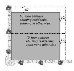
Figure 2-9 - Setback Requirements
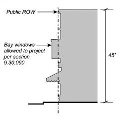
Figure 2-10 - Building Height and Profile
|
Development Standard |
CG Zone Requirement |
|---|---|
|
|
|
|
Setbacks - Minimum and, where noted, maximum setbacks required. See Section 9.30.090 for exceptions to these requirements. See Figure 2-11. |
|
|
Front |
10 ft |
|
Side - Interior (each) |
10 ft abutting to a residential zone; none required otherwise |
|
Side - Street side |
10 ft |
|
Rear |
10 ft abutting to a residential zone; none required otherwise |
|
Accessory structures |
See 9.42.030 |
|
|
|
|
Floor area ratio (FAR) -Maximum allowable FAR. See the definition and illustration of FAR in Article 10 (Glossary) |
|
|
Maximum FAR |
2.0 |
|
|
|
|
Height limit - Maximum allowable height of structures. See Section 9.30.040 (Height Limits and Exceptions) for height measurement requirements, and height limit exceptions. See Figure 2-12. |
|
|
Maximum height |
35 ft |
|
|
|
|
Landscaping - See Chapter 9.34 (Landscaping) |
|
|
Parking - See Chapter 9.36 (Parking and Loading) |
|
|
Special Standards - See Section 9.26.060.A |
|
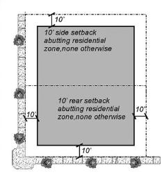
Figure 2-11 - Setback Requirements
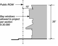
Figure 2-12 - Building Height and Profile
|
Development Standard |
CM Zone Requirement |
|---|---|
|
|
|
|
Setbacks - Minimum and, where noted, maximum setbacks required. See Section 9.30.090 for exceptions to these requirements. See Figure 2-13. |
|
|
Front |
None required |
|
Side - Interior (each) |
10 ft abutting to a residential zone; none required otherwise |
|
Side - Street side |
None required |
|
Rear |
10 ft abutting to a residential zone; none required otherwise |
|
Accessory structures |
See 9.42.030 |
|
|
|
|
Floor area ratio (FAR) -Maximum allowable FAR. See the definition and illustration of FAR in Article 10 (Glossary) |
|
|
Maximum FAR |
2.0 |
|
|
|
|
Height limit - Maximum allowable height of structures. See Section 9.30.040 (Height Limits and Exceptions) for height measurement requirements, and height limit exceptions. See Figure 2-14. |
|
|
Maximum height |
35 ft |
|
|
|
|
Landscaping - See Chapter 9.34 (Landscaping) |
|
|
Parking - See Chapter 9.36 (Parking and Loading) |
|
|
Special Standards - See Sections 9.26.060.A&B. |
|
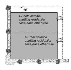
Figure 2-13 - Setback Requirements
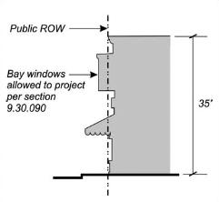
Figure 2-14 - Building Height and Profile
|
Development Standard |
CV Zone Requirement |
|---|---|
|
|
|
|
Setbacks - Minimum and, where noted, maximum setbacks required. See Section 9.30.090 for exceptions to these requirements. See Figure 2-15. |
|
|
Front |
15 ft |
|
Side - Interior (each) |
10 ft abutting to a residential zone; none required otherwise |
|
Side - Street side |
15 ft |
|
Rear |
10 ft abutting to a residential zone; none required otherwise |
|
Accessory structures |
See 9.42.030 |
|
|
|
|
Floor area ratio (FAR) -Maximum allowable FAR. See the definition and illustration of FAR in Article 10 (Glossary) |
|
|
Maximum FAR |
2.0 |
|
|
|
|
Height limit - Maximum allowable height of structures. See Section 9.30.040 (Height Limits and Exceptions) for height measurement requirements, and height limit exceptions. See Figure 2-16. |
|
|
Maximum height |
45 ft |
|
|
|
|
Landscaping - See Chapter 9.34 (Landscaping) |
|
|
Parking - See Chapter 9.36 (Parking and Loading) |
|
|
Special Standards - See Section 9.26.060.A. |
|

Figure 2-15 - Setback Requirements
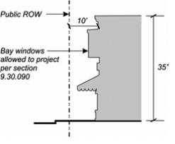
Figure 2-16 - Building Height and Profile
|
Development Standard |
IL Zone Requirement |
|---|---|
|
|
|
|
Setbacks - Minimum and, where noted, maximum setbacks required. See Section 9.30.090 for exceptions to these requirements. See Figure 2-17. |
|
|
Front |
10 ft |
|
Side - Interior (each) |
20 ft abutting to a residential zone; 10 ft required otherwise |
|
Side - Street side |
10 ft |
|
Rear |
20 ft abutting to a residential zone; 10 ft required otherwise |
|
Accessory structures |
See 9.42.030 |
|
|
|
|
Floor area ratio (FAR) -Maximum allowable FAR. See the definition and illustration of FAR in Article 10 (Glossary) |
|
|
Maximum FAR |
1.50 |
|
|
|
|
Height limit - Maximum allowable height of structures. See Section 9.30.040 (Height Limits and Exceptions) for height measurement requirements, and height limit exceptions. See Figure 2-18. |
|
|
Maximum height |
45 ft |
|
|
|
|
Landscaping - See Chapter 9.34 (Landscaping) |
|
|
Parking - See Chapter 9.36 (Parking and Loading) |
|
|
Special Standards - See Section 9.26.060.A. |
|
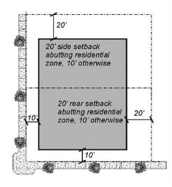
Figure 2-17 - Setback Requirements
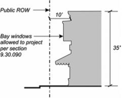
Figure 2-18 - Building Height and Profile
|
Development Standard |
IG Zone Requirement |
|---|---|
|
|
|
|
Setbacks - Minimum and, where noted, maximum setbacks required. See Section 9.30.090 for exceptions to these requirements. See Figure 2-19. |
|
|
Front |
25 ft |
|
Side - Interior (each) |
25 ft abutting to a residential zone; 10 ft required otherwise |
|
Side - Street side |
25 ft |
|
Rear |
25 ft abutting to a residential zone; 10 ft required otherwise |
|
Accessory structures |
See 9.42.030 |
|
|
|
|
Floor area ratio (FAR) -Maximum allowable FAR. See the definition and illustration of FAR in Article 10 (Glossary) |
|
|
Maximum FAR |
1.50 |
|
|
|
|
Height limit - Maximum allowable height of structures. See Section 9.30.040 (Height Limits and Exceptions) for height measurement requirements, and height limit exceptions. See Figure 2-20. |
|
|
Maximum height |
As determined by the review authority |
|
|
|
|
Landscaping - See Chapter 9.34 (Landscaping) |
|
|
Parking - See Chapter 9.36 (Parking and Loading) |
|
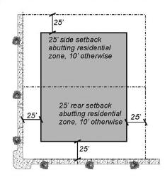
Figure 2-19 - Setback Requirements
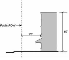
Figure 2-20 - Building Height and Profile
|
Development Standard |
PF Zone Requirement |
|---|---|
|
|
|
|
Setbacks - Minimum and, where noted, maximum setbacks required. See Section 9.30.090 for exceptions to these requirements. See Figure 2-21. |
|
|
Front |
None required |
|
Side - Interior (each) |
|
|
Side - Street side |
|
|
Rear |
|
|
Accessory structures |
|
|
|
|
|
Floor area ratio (FAR) -Maximum allowable FAR. See the definition and illustration of FAR in Article 10 (Glossary) |
|
|
Maximum FAR |
1.50 |
|
Height limit - Maximum allowable height of structures. See Section 9.30.040 (Height Limits and Exceptions) for height measurement requirements, and height limit exceptions. See Figure 2-22. |
|
|
Maximum height |
As determined by the review authority |
|
|
|
|
Landscaping - See Chapter 9.34 (Landscaping) |
|
|
Parking - See Chapter 9.36 (Parking and Loading) |
|
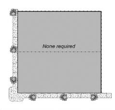
Figure 2-21 - Setback Requirements

Figure 2-22 - Building Height and Profile
(Ord. 1435, eff. 12/6/2013)
9.26.060 Commercial, Industrial, and Public Facility District Land Use Limitations
Proposed subdivisions, other development and new land uses within the commercial, industrial, and public facility zoning districts shall comply with the following standards, as applicable.
A. Retail Use Permit considerations. The review of a Use Permit for a retail use allowed by Section 9.26.030 shall include the following, at a minimum, in compliance with General Plan policy LU-3a.
1. Potential impact on existing and projected traffic conditions;
2. Impact on municipal utilities and services;
3. Impact on the physical and ecological characteristics of the site and surrounding area;
4. Impact on the community; and
B. CM zoning district requirements.
1. The existing Westwood, Bayside, Sunny Brae, and Greenview neighborhood centers are designated as multiple-use sites where additional retail establishments, personal and business services, and other neighborhood-oriented commercial services are encouraged.
2. An addition of more than 5,000 square feet to the Westwood, Bayside, Sunny Brae, and Greenview centers shall include residential units on upper floors, or in separate buildings, as determined by the review authority. An addition shall also include additional landscaping, improvement of parking lot designs, and provision of transit access, such as bus turnouts.
3. A new nonresidential use shall be developed as a mixed use project with a residential component.
9.26.070 Commercial, Industrial, and Public Facility Special Considerations
Proposed development and new land uses on parcels within the SCC (Special Considerations - Commercial), SCI (Special Considerations - Industrial), or SCP (Special Considerations - Public Facility) combining zone shall comply with the following requirements, as applicable, in compliance with General Plan Table LU-5, Table LU-7 or LU-8.
|
SCC Zone |
Area |
SCC Zone Requirements |
|
|
1a |
Giuntoli Lane at Hwy. 101: Graham site |
Commercial development should include consolidated access points, parking that is screened, and setbacks from the Mad River. This property is within the Urban Services Boundary, must be annexed, and has a Planned Development (:PD) overlay. |
|
|
1b |
2212 Jacoby Creek Road Assessor’s Parcel Number: 501-011-006 |
In addition to the permitted uses allowed in the base zone, the following uses shall be considered as permitted uses: studio – art, dance, martial arts, music, etc.; fitness/health facility; meeting facility, public and private; school – elementary, middle, secondary; school – specialized; and theater, auditorium. |
|
|
Future development shall provide special consideration to potential impacts to cultural and historical resources on the site as the property is listed on the National Register of Historic Places – National Register #85000353 and has had archaeological investigations and tribal consultation/monitoring. |
|||
|
Future development shall also not significantly diminish the school’s historical structure, context or setting. The maximum percentage of site area to be occupied by structures, parking, driveways and pavement shall not exceed 60%. |
|||
|
SCI Zone |
Area |
SCI Zone Requirements |
|
|
2 |
"K" Street Industrial area |
Provide live-work spaces; revitalize older industrial uses. |
|
|
3 |
West End Road Corridor |
Promote more intensive industrial uses. |
|
|
4 |
Aldergrove Industrial Park |
Coordinated light industrial development, with increased landscaping. |
|
|
5 |
Giuntoli Lane/Valley East Area: Zanzi site |
Planned Development for entire property to minimize access points on Giuntoli, and coordinate land uses, interior circulation, shared parking, and overall building layout. Constraints include setback area along Mad River. APN 507-141-042 may allow for a public facility type use to accommodate a future City park along the Mad River. A special consideration for this parcel shall include dual (Industrial Limited [IL] and/or Public Facility [PF] land use activities. |
|
|
6 |
Northcoast Hardwoods site |
Planned Development for entire property to minimize access points on Samoa, and coordinate land uses, interior circulation, shared parking, and overall building layout. |
|
|
7 |
Little Lake Industries (South I Street) |
Planned Development for the entire site shall include: |
|
|
1. |
An area not less than 25-feet wide adjacent and parallel to "I" Street shall be a landscape buffer between heavy manufacturing uses to the west and internal development on the site. Landscaping within the buffer strip shall include a dense planting of trees of species appropriate to the coastal environment. |
||
|
2. |
A multi-use coastal access pathway shall be included along the entire landscape buffer to connect the Samoa Boulevard area to the Arcata Marsh and bay shoreline. |
||
|
3. |
The former marsh areas at the southern portion of the property (south of the railroad tracks) shall be restored or recreated. |
||
|
4. |
A small portion of the site adjacent to the Marsh Commons area, or along Butcher Slough, may be suitable for limited residential development. |
||
|
5. |
A small portion of the site adjacent to the restored marsh area may be suitable as a site for an "eco-lodge" or other eco-tourism uses focused on coastal recreation. |
||
|
6. |
The northern portion of the site east of the landscape buffer may be developed as a "business park" with light industrial and business-service uses. Comprehensive development standards for the business park area, including sidewalks, landscaping, and building design, shall be included in the master plan for the site. |
||
|
7. |
A creekside conservation area shall be required parallel to the top of the bank of Butcher Slough. |
||
|
SCP |
Area |
SCP Zone Requirements |
|
|
8 |
Mad River Hospital Area APN’s 507-191-033, 507-191-076, 507-291-032 & 507-191-077 |
Hospital development on APN’s 507-191-077 and 507-291-032, in conjunction with an overall Master Site Plan, shall retain 50% contiguous open space, have adequate provisions for on site retention of stormwater, be compatible in scale with surrounding uses, provide permanent open space or conservation easements to the City of Arcata or a land trust, and limit extent of impervious surfaces (e.g. parking lots) as much as possible through a Planned Development. A conservation easement shall address provisions to: preserve prime agriculture soils; encourage limited agriculture activities; and promote trail systems, wellness gardens, and health related outdoor activities. On APN 507-291-032, north of Wiyot Way, a residential specific consideration shall be placed on this site that would allow for development of hospital related housing, including, but not limited to: life care facilities, assisted living facilities, medical related group quarters, medical services-extended care facilities, temporary housing for family members of hospital patients, or housing for doctors, nurses, and hospital staff per PC Resolution 08-11. If a Master Site Plan for the Mad River Hospital Area is not approved by the year 2020 for a Public Facility (PF) Land Use Designated areas on APN’s 507-191-077 and 507-291-032, then consideration should be given to reverting the PF designated lands back to an Agriculture Exclusive (A-E) designation. |
|
|
9 |
Sunset Fire Station Site APN 505-121-030 |
Development of a fire station compatible with the proposed Foster Avenue extension shall be allowed on this Public Facilities (PF) designated parcel. |
|
|
:SCI Zone |
Area |
:SCI Zone Requirements |
|
|
10 |
Boyd Road Annexation (Portion) The following APNs 507-381-001, ‑004, ‑005 and ‑007 are zoned IL:SCI:SP (Note: the Flake Board property (-001) is developed only with a well and is not authorized to be further developed at this time) |
507-381-004, -005, -007 – Eureka Ready Mix. The Special Considerations zone will allow the continued extraction, manufacture and processing of rock products, concrete and asphalt batch plant operations and other directly related ancillary equipment/structures. Existing uses on APNs -004, -005 and -007 may operate in perpetuity unless and until such time as the uses described above cease in entirety for a period of three years. Following the three-year period, any new use must conform to IL zoning. |
|
(Ord. 1398, eff. 1/15/2010; Ord. 1428, eff. 5/1/2015; Ord. 1458, eff. 6/19/2015)


