Chapter 19.162
ACCESS AND CIRCULATION
Sections:
19.162.020 Vehicular access and circulation.
19.162.030 Pedestrian access and circulation.
19.162.010 Purpose.
The purpose of this chapter is to ensure that developments provide safe and efficient access and circulation, for pedestrians and vehicles. FMC 19.162.020 provides standards for vehicular access and circulation. FMC 19.162.030 provides standards for pedestrian access and circulation. Standards for transportation improvements are provided in Chapter 19.165 FMC. (Ord. 6-2001 § 1)
19.162.020 Vehicular access and circulation.
A. Intent and Purpose. The intent of this section is to manage vehicle access to development through a connected street system, while preserving the flow of traffic in terms of safety, roadway capacity, and efficiency. Access shall be managed to maintain an adequate “level of service” and to maintain the “functional classification” of roadways as required by the city’s transportation system plan. Major roadways, including highways, arterials, and collectors, serve as the primary system for moving people and goods. “Access management” is a primary concern on these roads. Local streets and alleys provide access to individual properties. If vehicular access and circulation are not properly designed, these roadways will be unable to accommodate the needs of development and serve their transportation function. This section attempts to balance the right of reasonable access to private property with the right of the citizens of the city and the state of Oregon to safe and efficient travel. It also requires all developments to construct planned streets (arterials and collectors) and to extend local streets.
To achieve this policy intent, state and local roadways have been categorized in the transportation system plan by function and classified for access purposes based upon their level of importance and function (see Chapter 19.165 FMC). Regulations have been applied to these roadways for the purpose of reducing traffic accidents, personal injury, and property damage attributable to access systems, and to thereby improve the safety and operation of the roadway network. This will protect the substantial public investment in the existing transportation system and reduce the need for expensive remedial measures. These regulations also further the orderly layout and use of land, protect community character, and conserve natural resources by promoting well-designed road and access systems and discouraging the unplanned subdivision of land.
B. Applicability. This section shall apply to all public streets within the city and to all properties that abut these streets.
C. Access Permit Required. Access to a public street requires an access permit in accordance with the following procedures:
1. Permits for access to city streets shall be subject to review and approval by the city engineer based on the standards contained in this chapter, and the provisions of the transportation standards. An access permit may be in the form of a letter to the applicant, or it may be attached to a land use decision notice as a condition of approval. In either case, an access permit will be reviewed consistent with the procedures required for the complementary development permit. If no development permit is requested, the access permit shall be reviewed consistent with a Type III process.
2. Permits for access to state highways shall be subject to review and approval by the Oregon Department of Transportation (ODOT), except when ODOT has delegated this responsibility to the city or Multnomah County. In that case, the city or county shall determine whether access is granted based on its adopted standards.
3. Permits for access to county highways shall be subject to review and approval by Multnomah County, except where the county has delegated this responsibility to the city, in which case the city shall determine whether access is granted based on adopted county standards.
D. Traffic Study Requirements. The city may require a traffic study prepared by a qualified professional to determine access, circulation and other transportation requirements.
A traffic study must be provided for any proposed development that includes more than 10 dwellings or generates at least 100 vehicle trips per day. The traffic study shall include those adjacent intersections that will receive more than 50 vehicle trips per day.
A freight network impact statement is to be included in all traffic studies for proposed developments on properties identified as industrial lands in Title 4 of the Metro Urban Growth Management Functional Plan. The purpose of this statement is to analyze potential adverse effects of the proposed development on the regional freight system as identified in the regional transportation plan (RTP) and the Fairview transportation system plan. Freight routes located in Fairview include Interstate 84, Marine Drive, 223rd Avenue, Fairview Parkway, Sandy Boulevard, and Glisan Street.
E. Conditions of Approval. The city may require the closing or consolidation of existing curb cuts or other vehicle access points, recording of reciprocal access easements (i.e., for shared driveways), development of a frontage street, installation of traffic control devices, and/or other mitigation as a condition of granting an access permit, to ensure the safe and efficient operation of the street. When obtaining access to off-street parking areas (both to and from), backing onto a public street shall not be permitted, except for residential driveways serving single-unit, duplex, triplex and quadplex lots.
F. Access Options. When vehicle access is required for development (i.e., for off-street parking, delivery, service, drive-through facilities, etc.), access shall be provided by one of the following methods. These methods are “options” to the developer/subdivider, unless one method is specifically required by “Special Standards for Certain Uses.” A minimum of 10 feet per lane is required.
1. Option 1. Access is from an existing or proposed alley or mid-block lane. If a property has access to an alley or lane, direct access to a public street is not permitted.
2. Option 2. Access is from a private street or driveway connected to an adjoining property that has direct access to a public street (i.e., “shared driveway”). A public access easement covering the driveway shall be recorded in this case to assure access to the closest public street for all users of the private street/drive.
3. Option 3. Access is from a public street adjacent to the development parcel. If practicable, the owner/developer may be required to close or consolidate an existing access point as a condition of approving a new access. Street accesses shall comply with the access spacing.
4. Subdivisions Fronting onto an Arterial Street. New residential subdivisions fronting onto an arterial street shall be required to provide alleys or secondary (local or collector) streets for access to individual lots. When alleys or secondary streets cannot be constructed due to topographic or other physical constraints, access may be provided by consolidating driveways for clusters of two or more lots (e.g., includes flag lots and mid-block lanes).
5. Double-Frontage Lots. When a lot has frontage onto two or more streets, access shall be provided first from the street with the lowest classification. For example, access shall be provided from a local street before a collector or arterial street. Except for corner lots, the creation of new double-frontage lots shall be prohibited in the residential district, unless topographic or physical constraints require the formation of such lots. When double-frontage lots are permitted in the residential district, a landscape buffer with trees and/or shrubs and ground cover not less than 20 feet wide shall be provided between the back yard fence/wall and the sidewalk or street; maintenance shall be assured by the owner (i.e., through homeowners association, etc.).
Important cross-references to other code sections: Provisions in Articles II and III of this title may require buildings placed at or near the front property line and driveways and parking areas oriented to the side or rear yard. The city may require the dedication of public right-of-way and construction of a street (e.g., frontage road, alley or other street) when the development impact is proportionate to the need for such a street, and the street is identified by the Comprehensive Plan or an adopted local streets plan. (Please refer to the transportation standards in Chapter 19.165 FMC.)
G. Access Spacing. Access spacing ensures safe connections to local and arterial streets. Driveway accesses shall be separated from other driveways and street intersections in accordance with the following standards and procedures:
1. Local Streets. A minimum of 50 feet separation (as measured from the sides of the driveway/street) shall be required on local streets (i.e., streets not designated as collectors or arterials), except as provided in subsection (G)(3) of this section.
2. Arterial and Collector Streets. Access spacing on collector and arterial streets, and at controlled intersections (i.e., with four-way stop sign or traffic signal) shall be determined based on the policies and standards contained in the city’s transportation system plan. Access to Interstate 84 is subject to the jurisdiction of ODOT.
3. Special Provisions for All Streets. Direct street access may be restricted for some land uses, in conformance with the provisions of Chapters 19.20 through 19.155 – Land Use Districts. For example, access consolidation, shared access, and/or access separation greater than that specified by subsections (G)(1) and (G)(2) of this section may be required by the city, county or ODOT for the purpose of protecting the function, safety and operation of the street for all users. (See subsection I of this section.) Where no other alternatives exist, the permitting agency may allow construction of an access connection along the property line farthest from an intersection. In such cases, directional connections (i.e., right in/out, right in only, or right out only) may be required.
H. Number of Access Points. Reducing the number of access points on a street provides pedestrians fewer obstructions, fewer points at which automobile traffic crosses the sidewalk, and fewer opportunities for conflicts between through traffic and vehicles using access points.
For single-unit detached, one street access point is permitted per lot, when alley access cannot otherwise be provided.
I. Shared Driveways. Shared driveways serve to reduce impermeable surfaces, reduce visual blight associated with large expanses of pavement, and provide more linear curb space for on-street parking.
The number of driveway and private street intersections with public streets shall be minimized by the use of shared driveways with adjoining lots where feasible. The city shall require shared driveways as a condition of land division or site design review, as applicable, for traffic safety and access management purposes in accordance with the following standards:
1. Shared driveways and frontage streets may be required to consolidate access onto a collector or arterial street. When shared driveways or frontage streets are required, they shall be stubbed to adjacent developable parcels to indicate future extension. “Stub” means that a driveway or street temporarily ends at the property line, but may be extended in the future as the adjacent parcel develops. “Developable” means that a parcel is either vacant or it is likely to receive additional development (i.e., due to infill or redevelopment potential).
2. Access easements (i.e., for the benefit of affected properties) shall be recorded for all shared driveways, including pathways, at the time of final plat approval or as a condition of site development approval.
3. Exception. Shared driveways are not required when existing development patterns or physical constraints (e.g., topography, parcel configuration, and similar conditions) prevent extending the street/driveway in the future.
J. Figure 19.162.020.J provides examples of street layout and connectivity.
Figure 19.162.020.J – Street Connectivity and Formation of Blocks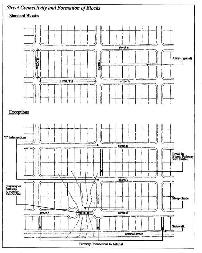
K. Street Connectivity and Formation of Blocks Required. In order to promote efficient vehicular and pedestrian circulation throughout the city, land divisions and large site developments shall produce complete blocks bounded by a connecting network of public and/or private streets, in accordance with the following standards:
1. Mixed-use and residential development proposed on sites five acres or greater must submit a site plan that identifies conceptual street connections that are consistent with the transportation system plan.
2. Block Length and Perimeter. The maximum block length and perimeter shall not exceed:
a. Five hundred thirty feet length and 1,600 feet perimeter in the residential district;
b. Two hundred feet length and 1,200 feet perimeter in the town center commercial district, except as provided by FMC 19.65.050, Block layout;
c. Three hundred feet length and 1,200 feet perimeter in the corridor commercial district and neighborhood commercial;
d. Not applicable to the general industrial district; and
e. Seven hundred feet length and 1,700 feet perimeter in the light industrial district, except as required for commercial developments subject to FMC 19.80.060(F).
3. Street Standards. Public and private streets shall also conform to FMC 19.165.020, Transportation standards, FMC 19.162.030, Pedestrian access and circulation, and applicable Americans with Disabilities Act (ADA) design standards.
4. A variance to street spacing standards may be granted pursuant to FMC 19.520.030 (Class B variances) when resources are present that are mapped on the Natural Resources Map, where street spacing can be achieved at a minimum of 800 feet and no greater than 1,200 feet.
5. Exception. Exceptions to the above standards may be granted when blocks are divided by one or more pathway(s), where spacing is no more than 330 feet as measured from the right-of-way or easement line and in conformance with the provisions of FMC 19.162.030(A). Pathways shall be located to minimize out-of-direction travel by pedestrians and may be designed to accommodate bicycles.
L. Driveway Openings. All driveway openings must comply with the “Standard Specifications for Public Works Construction,” pages 53 – 55. Driveway openings or curb cuts shall be within the minimum width necessary to provide the required number of vehicle travel lanes (10 feet for each travel lane). The following standards (i.e., as measured where the front property line meets the sidewalk or right-of-way) are required to provide adequate site access, minimize surface water runoff, and avoid conflicts between vehicles and pedestrians:
1. Single-unit dwelling, duplex, triplex, quadplex, and townhouse uses shall have a minimum driveway width of 10 feet, and a maximum width of 24 feet, except that one recreational vehicle pad driveway may be provided in addition to the standard driveway for lots containing more than 10,000 square feet of area.
2. Multiple-unit uses and cottage clusters with between four and seven dwelling units shall have a minimum driveway width of 20 feet, and a maximum width of 24 feet.
3. Multiple-unit uses and cottage clusters with more than eight dwelling units, and off-street parking areas with 16 or more parking spaces, shall have a minimum driveway width of 24 feet, and a maximum width of 30 feet.
4. Access widths for all other uses shall be based on 10 feet of width for every travel lane, except that driveways providing direct access to parking spaces shall conform to the parking area standards in Chapter 19.164 FMC, Vehicle and Bicycle Parking.
5. Driveway Aprons. Driveway aprons (when required) shall be constructed of concrete and shall be installed between the street right-of-way and the private drive, as shown above. Driveway aprons shall conform to ADA standards for sidewalks and pathways, which require a continuous route of travel that is a minimum of three feet in width, with a cross slope not exceeding two percent.
Figure 19.162.020.L – Examples of Acceptable Driveway Openings Next to Sidewalks/Pathways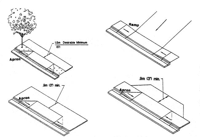
M. Fire Access and Parking Area Turnarounds. A fire equipment access drive shall be provided for any portion of an exterior wall of the first story of a building that is located more than 150 feet from an existing public street or approved fire equipment access drive. Parking areas shall provide adequate aisles or turnaround areas for service and delivery vehicles so that all vehicles may enter the street in a forward manner. For requirements related to cul-de-sacs, please refer to Chapter 19.165 FMC.
N. Vertical Clearances. Driveways, private streets, aisles, turnaround areas and ramps shall have a minimum vertical clearance of 13 feet 6 inches for their entire length and width.
O. Vision Clearance. No signs, structures or vegetation in excess of three feet in height shall be placed in “vision clearance areas,” as shown above. The city engineer upon finding that more sight distance is required may increase the minimum vision clearance area (i.e., due to traffic speeds, roadway alignment, etc.).
Figure 19.162.020.O – Vision Clearance Areas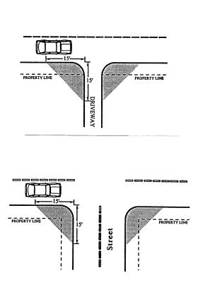
P. Construction. The following development and maintenance standards shall apply to all driveways and private streets:
1. Surface Options. Driveways, parking areas, aisles, and turnarounds may be paved with asphalt, concrete or comparable surfacing, or a durable nonpaving material may be used to reduce surface water runoff and protect water quality. Paving surfaces shall be subject to review and approval by the city engineer.
2. Surface Water Management. When a paved surface is used, all driveways, parking areas, aisles and turnarounds shall have on-site collection or infiltration of surface waters to eliminate sheet flow of such waters onto public rights-of-way and abutting property. Surface water facilities shall be constructed in conformance with city standards.
3. Driveway Aprons. When driveway approaches or “aprons” are required to connect driveways to the public right-of-way, they shall be paved with concrete surfacing (see also subsection L of this section). (Ord. 1-2024 § 1 (Att. A); Ord. 2-2017 § 1 (Exh. A); Ord. 5-2009 § 2 (Att. 1); Ord. 6-2001 § 1)
19.162.030 Pedestrian access and circulation.
The standards presented in this code provide standards for safe, connected and user-friendly pedestrian connections and pathways that join neighborhoods and buildings within a development.
A. Pedestrian Access and Circulation. To ensure safe, direct and convenient pedestrian circulation, all developments, except residential development four units or less, townhomes and cottage clusters, shall provide a continuous pedestrian and/or multi-use pathway system. (Pathways only provide for pedestrian circulation. Multi-use pathways accommodate pedestrians and bicycles.) The system of pathways shall be designed based on the standards in subsections (A)(1) through (5) of this section:
1. Continuous Pathways. The pathway system shall extend throughout the development site, and connect to all future phases of development, adjacent trails, public parks and open space areas.
2. Safe, Direct, and Convenient Pathways. Pathways within developments shall provide safe, reasonably direct and convenient connections between primary building entrances and all adjacent streets, based on the following definitions:
a. “Reasonably direct” means a route that does not deviate unnecessarily from a straight line or a route that does not involve a significant amount of out-of-direction travel for likely users.
b. “Safe and convenient” means bicycle and pedestrian routes that are reasonably free from hazards and provide a reasonably direct route of travel between destinations.
c. For commercial, industrial, mixed use, public, and institutional buildings, the “primary entrance” is the main public entrance to the building. In the case where no public entrance exists, street connections shall be provided to the main employee entrance.
d. For residential buildings the “primary entrance” is the front door (i.e., facing the street). For multi-unit buildings in which each unit does not have its own exterior entrance, the “primary entrance” may be a lobby, courtyard or breezeway, which serves as a common entrance for more than one dwelling.
3. Connections Within Development. For all developments subject to site design review, pathways shall connect all building entrances to one another. In addition, pathways shall connect all parking areas, storage areas, recreational facilities and common areas (as applicable), and adjacent developments to the site, as applicable.
a. Pedestrian connections shall be located throughout the parking lot, and shall connect at a minimum the following:
i. Building entrances;
ii. Existing or planned pedestrian facilities in the adjacent public rights-of-way;
iii. Transit stops; and
iv. Accessible parking spaces.
4. Street Connectivity. Pathways (for pedestrians and bicycles) shall be provided at or near midblock where the block length exceeds the length required by FMC 19.162.020. Pathways shall also be provided where cul-de-sacs or dead-end streets are planned, to connect the ends of the streets together, to other streets, and/or to other developments, as applicable. Pathways used to comply with these standards shall conform to all of the following criteria:
a. Multi-use pathways (i.e., for pedestrians and bicyclists) are no less than 10 feet wide and located within a 20-foot-wide right-of-way or easement that allows access for emergency vehicles.
b. If the streets within the subdivision or neighborhood are lighted, the pathways shall also be lighted.
c. Stairs or switchback paths using a narrower right-of-way/easement may be required in lieu of a multi-use pathway where grades are steep.
d. The city may require landscaping within the pathway easement/right-of-way for screening and the privacy of adjoining properties.
e. The hearings body or planning director may determine, based upon facts in the record, that a pathway is impracticable due to: physical or topographic conditions (e.g., freeways, railroads, extremely steep slopes, sensitive lands, and similar physical constraints); buildings or other existing development on adjacent properties that physically prevent a connection now or in the future, considering the potential for redevelopment; and sites where the provisions of recorded leases, easements, covenants, restrictions, or other agreements recorded as of the effective date of this code prohibit the pathway connection.
5. Connections to Other Facilities. Proposed pathways shall be located to provide access to existing or planned commercial services and other neighborhood facilities, such as schools, shopping areas and park and transit facilities. To the greatest extent possible, access shall be reasonably direct, providing a route or routes that do not deviate unnecessarily from a straight line or that do not involve a significant amount of out-of-direction travel.
Figure 19.162.030.A – Pedestrian Pathway System for Multi-Unit Development (Typical)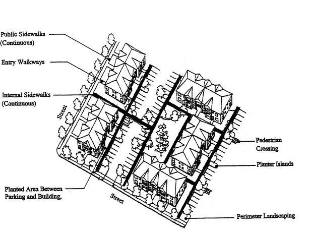
B. Design and Construction. Pathways shall conform to all of the standards in subsections (B)(1) through (B)(5) of this section:
1. Vehicle/Pathway Separation. Where pathways are parallel and adjacent to a driveway or street (public or private), they shall be raised six inches and curbed, or separated from the driveway/street by a five-foot minimum strip with bollards, a landscape buffer, or other physical barrier. If a raised path is used, the ends of the raised portions must be equipped with curb ramps.
2. Housing/Pathway Separation. Pedestrian pathways shall be separated a minimum of five feet from all residential living areas on the ground floor, except at building entrances. Separation is measured as measured from the pathway edge to the closest dwelling unit. The separation area shall be landscaped in conformance with the provisions of Chapter 19.163 FMC, Landscaping, Street Trees, Fences and Walls. No pathway/building separation is required for commercial, industrial, public, or institutional uses.
3. Crosswalks. Where pathways cross a parking area, driveway, or street (“crosswalk”), they shall be clearly marked with contrasting paving materials, humps/raised crossings.
4. Pathway Surface. Pathway surfaces shall be concrete, asphalt, brick/masonry pavers, or other durable surface, at least five feet wide, and shall conform to ADA requirements. Multi-use paths (i.e., for bicycles and pedestrians) shall be the same materials, at least 10 feet wide. (See also Chapter 19.165 FMC, Transportation Standards for public, multi-use pathway standard.)
5. Accessible Routes. Pathways shall comply with the Americans with Disabilities Act, which requires accessible routes of travel.
Figure 19.162.030.B – Pathway Standards (Typical)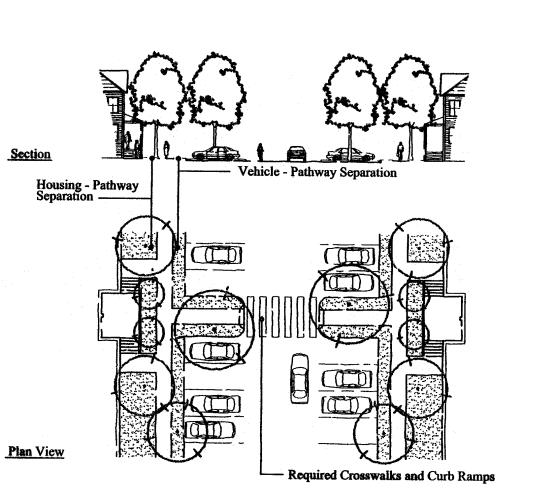
(Ord. 4-2024 § 1 (Att. A); Ord. 1-2024 § 1 (Att. A); Ord. 2-2017 § 1 (Exh. A); Ord. 6-2001 § 1)


