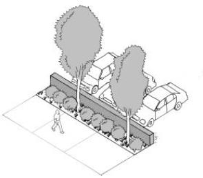
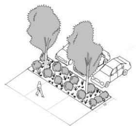
Chapter 20.50
General Development Standards
Sections:
Subchapter 1. Dimensions and Density for Development
20.50.020 Dimensional requirements.
20.50.030 Lot width and lot area – Measurements.
20.50.040 Setbacks – Designation and measurement.
20.50.050 Building height – Standards.
Subchapter 2. Single-Family Detached Residential Design
20.50.070 Site planning – Front yard setback – Standards.
20.50.080 Site planning – Rear and side yard setbacks – Standards.
20.50.100 Location of accessory structures within required yard setbacks – Standards.
20.50.110 Fences and walls – Standards.
20.50.115 Lighting – Standards.
Subchapter 3. Single-Family Attached Residential Design
20.50.130 Administrative design review.
20.50.140 Thresholds – Required site improvements.
20.50.150 Overlapping standards.
20.50.160 Site design – Standards.
20.50.170 Building design – Standards.
20.50.180 Outdoor lighting – Standards.
20.50.190 Fences and walls – Standards.
Subchapter 4. Commercial and Multifamily Zone Design
20.50.225 Administrative design review.
20.50.230 Threshold – Required site improvements.
20.50.233 Threshold – Required building design.
20.50.235 Site planning – Setbacks – Standards.
20.50.260 Outdoor seating design.
Subchapter 5. Tree Conservation, Land Clearing and Site Grading Standards
20.50.300 General requirements.
20.50.310 Exemptions from permit.
20.50.320 Specific activities subject to the provisions of this subchapter.
20.50.330 Project review and approval.
20.50.340 Basic operating conditions and standards of performance.
20.50.350 Development standards for clearing activities.
20.50.360 Tree replacement and site restoration.
20.50.370 Tree protection standards.
Subchapter 6. Parking, Access and Circulation
20.50.390 Minimum off-street parking requirements – Standards.
20.50.400 Reductions to minimum parking requirements.
20.50.410 Parking design standards.
20.50.420 Vehicle access and circulation – Standards.
20.50.440 Bicycle facilities – Standards.
Subchapter 7. Landscaping
20.50.457 Administrative design review.
20.50.460 Landscaping – Types of landscaping screens – Standards.
20.50.470 Street frontage landscaping for parking lots.
20.50.480 Street trees and landscaping within the right-of-way – Standards.
20.50.490 Landscaping along interior lot line – Standards.
20.50.500 Internal landscaping for parking area.
20.50.510 Alternative landscape design.
20.50.520 General standards for landscape installation and maintenance.
Subchapter 8. Signs
20.50.570 Building-mounted signs.
20.50.590 Nonconforming signs.
20.50.620 Shoreline Place (Aurora Square Community Renewal Area) sign standards.
Subchapter 9. Deep Green Incentive Program (DGIP)
20.50.630 Deep Green Incentive Program (DGIP).
Subchapter 10. Cottage Housing
20.50.710 Administrative design review.
20.50.720 Site design – Standards.
20.50.730 Building design – Standards.
20.50.740 Outdoor lighting standards.
20.50.750 Fences and walls – Standards.
Subchapter 11. Transfer of Development Rights Program (TDR)
20.50.800 Transfer of Development Rights Program (TDR).
Subchapter 1.
Dimensions and Density for Development
20.50.010 Purpose.
The purpose of this subchapter is to establish basic dimensional standards for development at a range of densities consistent with public health and safety and the adopted Comprehensive Plan.
The basic standards for development shall be implemented in conjunction with all applicable Code provisions. (Ord. 706 § 1 (Exh. A), 2015; Ord. 654 § 1 (Exh. 1), 2013; Ord. 238 Ch. V § 1(A), 2000).
20.50.020 Dimensional requirements.
A. Table 20.50.020(1) – Densities and Dimensions in Residential Zones.
Note: Exceptions to the numerical standards in this table are noted in parentheses and described below.
|
Residential Zones |
||||||||
|---|---|---|---|---|---|---|---|---|
|
STANDARDS |
R-4 |
R-6 |
R-8 |
R-12 |
R-18 |
R-24 |
R-48 |
TC-4 |
|
Base Density: Dwelling Units/Acre |
4 du/ac (21) |
6 du/ac (7) (21) |
8 du/ac (21) |
12 du/ac (21) |
18 du/ac |
24 du/ac |
48 du/ac |
Based on bldg. bulk limits |
|
Min. Density |
4 du/ac |
4 du/ac |
4 du/ac |
6 du/ac |
8 du/ac |
10 du/ac |
12 du/ac |
Based on bldg. bulk limits |
|
Min. Lot Width (2) |
50 ft |
50 ft |
50 ft |
30 ft |
30 ft |
30 ft |
30 ft |
N/A |
|
Min. Lot Area (2) (13) |
7,200 sq ft |
7,200 sq ft |
5,000 sq ft |
2,500 sq ft |
2,500 sq ft |
2,500 sq ft |
2,500 sq ft |
N/A |
|
Min. Front Yard Setback (2) (3) (14) |
20 ft |
20 ft |
10 ft |
10 ft |
10 ft |
10 ft |
10 ft |
10 ft |
|
Min. Rear Yard Setback (2) (4) (5) |
15 ft |
15 ft |
5 ft |
5 ft |
5 ft |
5 ft |
5 ft |
5 ft |
|
Min. Side Yard Setback (2) (4) (5) |
5 ft min. |
5 ft min. |
5 ft |
5 ft |
5 ft |
5 ft |
5 ft |
5 ft |
|
Base Height (9) |
30 ft (35 ft with pitched roof) (21) |
30 ft (35 ft with pitched roof) (21) |
35 ft (21) |
35 ft (21) |
35 ft (40 ft with pitched roof) |
35 ft (40 ft with pitched roof) (16) |
35 ft (40 ft with pitched roof) (8) (16) |
35 ft (16) |
|
Max. Building Coverage (2) (6) |
35% |
35% |
45% |
55% |
60% |
70% |
70% |
N/A |
|
Max. Hardscape (2) (6) |
45% |
50% |
65% |
75% |
85% |
85% |
90% |
90% |
Table 20.50.020(2) – Densities and Dimensions in Mixed-Use Residential Zones.
Note: Exceptions to the numerical standards in this table are noted in parentheses and described below.
|
STANDARDS |
MUR-35' |
MUR-45' |
MUR-70' |
|---|---|---|---|
|
Base Density: Dwelling Units/Acre |
N/A |
N/A |
N/A |
|
Min. Density |
12 du/ac (17) |
18 du/ac |
48 du/ac |
|
Min. Lot Width (2) |
N/A |
N/A |
N/A |
|
Min. Lot Area (2) |
N/A |
N/A |
N/A |
|
Min. Front Yard Setback (2) (3) |
0 ft if located on an arterial street 10 ft on nonarterial street 22 ft if located on 145th Street (15) |
15 ft if located on 185th Street (15) 0 ft if located on an arterial street 10 ft on nonarterial street 22 ft if located on 145th Street (15) |
15 ft if located on 185th Street (15) 22 ft if located on 145th Street (15) 0 ft if located on all other streets |
|
Min. Rear Yard Setback (2) (4) (5) |
5 ft |
5 ft |
5 ft (20) |
|
Min. Side Yard Setback (2) (4) (5) |
5 ft |
5 ft |
5 ft (20) |
|
Base Height (9) (16) |
35 ft |
45 ft |
70 ft (11) (12) (13) |
|
Max. Building Coverage (2) (6) |
N/A |
N/A |
N/A |
|
Max. Hardscape (2) (6) |
85% |
90% |
90% |
Exceptions to Table 20.50.020(1) and Table 20.50.020(2):
(1) Repealed by Ord. 462.
(2) These standards may be modified to allow unit lot developments, mixed single-family attached developments and zero lot line developments. Setback variations apply to internal lot lines only. Overall site must comply with setbacks, building coverage and hardscape limitations; limitations for individual lots may be modified.
(3) For single-family detached development exceptions to front yard setback requirements, please see SMC 20.50.070.
(4) For single-family detached development exceptions to rear and side yard setbacks, please see SMC 20.50.080.
(5) For developments consisting of three or more dwellings located on a single parcel, the building setback shall be 15 feet along any property line abutting R-4 or R-6 zones. Please see SMC 20.50.160. This standard shall not apply to cottage housing developments.
(6) The maximum building coverage shall be 35 percent and the maximum hardscape area shall be 50 percent for single-family detached development located in the R-12 zone.
(7) The base density for single-family detached dwellings on a single lot that is less than 14,400 square feet shall be calculated using a whole number, without rounding up, except when a single lot is divided by a zone boundary. Refer to subsection (D)(2)(a) of this section for calculation of density when a single lot is divided by a zone boundary.
(8) For development on R-48 lots abutting R-12, R-18, R-24, R-48, NB, CB, MB, CZ and TC-1, 2 and 3 zoned lots, the maximum height allowed is 50 feet and may be increased to a maximum of 60 feet with the approval of a conditional use permit.
(9) Base height for public and private K through 12 schools in all zoning districts except R-4 is 50 feet. Base height may be exceeded by gymnasiums to 55 feet and by theater fly spaces to 72 feet.
(10) Repealed by Ord. 968.
(11) Developments that exceed the base height and do not qualify for a height bonus within the Deep Green Incentive Program in SMC 20.50.630, or the significant tree retention bonus in footnote 12, or the allowable exceptions to height in SMC 20.50.050, may exceed the base height and develop to the maximum allowable height of 140 feet, subject to administrative design review approval and to the following:
a. The affordable housing requirements for MUR-70'+ in SMC 20.40.235 are satisfied;
b. The development provides nonresidential space of at least 10,000 square feet;
c. At least 20 percent of the public places and multifamily open space required in SMC 20.50.240(F) and (G) shall be open and accessible to the public. This requirement does not include any area required for a public access easement as described in SMC 20.70.340(E);
d. The development shall provide two percent of the building construction valuation to be paid by the applicant for contribution to fund public parks, open space, art, or other recreational opportunities open and accessible to the public within the station subarea as defined in the City’s Parks, Recreation, and Open Space Plan. The applicant’s contribution shall be paid to the City; and
e. The development shall meet the requirements to achieve certification under one of the following sustainable development programs: (i) LEED Platinum; or (ii) 5-Star Built Green; or (iii) Passive House Institute US (PHIUS)+ combined with Salmon Safe; or (iv) Zero Energy combined with Salmon Safe.
(12) Base height in the MUR-70' zone may be increased up to 80 feet when at least 10 percent of the significant trees on site are retained and up to 90 feet when at least 20 percent of the significant trees on site are retained.
(13) All building facades in the MUR-70' zone fronting on any street shall be stepped back a minimum of 10 feet for that portion of the building above 45 feet in height. Alternatively, a building in the MUR-70' zone may be set back 10 feet at ground level instead of providing a 10-foot step-back at 45 feet in height. MUR-70' fronting on 185th Street shall be set back an additional 10 feet to use this alternative because the current 15-foot setback is planned for street dedication and widening of 185th Street.
(14) The minimum lot area may be reduced proportional to the amount of land needed for dedication of facilities to the City as defined in Chapter 20.70 SMC.
(15) The exact setback along 145th Street (Lake City Way to Fremont Avenue) and 185th Street (Fremont Avenue to 10th Avenue NE), up to the maximum described in Table 20.50.020(2), will be determined by the Public Works Department through a development application.
(16) Base height may be exceeded by 15 feet for rooftop structures such as elevators, arbors, shelters, barbeque enclosures and other structures that provide open space amenities.
(17) Single-family detached dwellings that do not meet the minimum density are permitted in the MUR-35' zone subject to the R-6 development standards.
(18) The minimum front yard setback in the MUR-70' zone may be reduced to five feet on a nonarterial street if 20 percent of the significant trees on site are retained.
(19) The maximum hardscape for public and private kindergarten through grade 12 schools is 75 percent.
(20) Setback may be reduced to zero feet when a direct pedestrian connection is provided to adjacent light rail transit stations, light rail transit parking garages, transit park and ride lots, or transit access facilities.
(21) For cottage housing developments, see the density and dimensional standards as described in SMC 20.40.300.
Table 20.50.020(3) – Dimensions for Development in Commercial Zones
Note: Exceptions to the numerical standards in this table are noted in parentheses and described below.
|
Commercial Zones |
||||
|---|---|---|---|---|
|
STANDARDS |
Neighborhood Business (NB) |
Community Business (CB) |
Mixed Business (MB) |
Town Center (TC-1, 2 & 3) |
|
Min. Front Yard Setback (Street) (1) (2) (5) (see Transition Area Setback, SMC 20.50.021) |
0 ft |
0 ft |
0 ft |
0 ft |
|
Min. Side and Rear Yard Setback from Commercial Zones and the MUR-70' zone |
0 ft |
0 ft |
0 ft |
0 ft |
|
Min. Side and Rear Yard Setback from R-4, R-6 and R-8 Zones (see Transition Area Setback, SMC 20.50.021) |
20 ft |
20 ft |
20 ft |
20 ft |
|
Min. Side and Rear Yard Setback from TC-4, R-12 through R-48 Zones, MUR-35' and MUR-45' Zones |
15 ft |
15 ft |
15 ft |
15 ft |
|
Base Height (3) |
50 ft |
60 ft (6) |
70 ft |
70 ft |
|
Hardscape (4) |
85% |
85% (7) |
95% |
95% |
Exceptions to Table 20.50.020(3):
(1) Front yards may be used for outdoor display of vehicles to be sold or leased.
(2) Front yard setbacks, when in transition areas (SMC 20.50.021(A)) shall be a minimum of 15 feet except on rights-of-way that are classified as principal arterials or when R-4, R-6, or R-8 zones have the Comprehensive Plan designation of Public Open Space.
(3) The following structures may be erected above the height limits in all commercial zones:
a. Roof structures housing or screening elevators, stairways, tanks, mechanical equipment required for building operation and maintenance, skylights, flagpoles, chimneys, utility lines, towers, and poles; provided, that no structure shall be erected more than 10 feet above the height limit of the district, whether such structure is attached or freestanding except as provided in subsection (3)(f) of these exceptions. WTF provisions (SMC 20.40.600) are not included in this exception.
b. Parapets, firewalls, and railings shall be limited to four feet in height.
c. Steeples, crosses, and spires when integrated as an architectural element of a building may be erected up to 18 feet above the base height of the district.
d. Base height may be exceeded by gymnasiums to 55 feet and for theater fly spaces to 72 feet.
e. Solar energy collector arrays, small scale wind turbines, or other renewable energy equipment have no height limits.
f. Base height may be exceeded by 15 feet for rooftop structures such as elevators, arbors, shelters, barbeque enclosures and other structures that provide open space amenities and their access.
(4) Site hardscape shall not include the following:
a. Areas of the site or roof covered by solar photovoltaic arrays or solar thermal collectors.
b. Intensive vegetative roofing systems.
(5) The exact setback along 145th Street, up to the maximum described in Table 20.50.020(2), will be determined by the Public Works Department through a development application.
(6) Base height may be exceeded for multifamily buildings providing ground floor nonresidential uses pursuant to SMC 20.40.465.
(7) Maximum hardscape may be exceeded for qualifying multifamily buildings pursuant to SMC 20.40.465.
B. Base Density Calculation. The base density for an individual site shall be calculated by multiplying the site area (in acres) by the applicable number of dwelling units. When calculation results in a fraction, the fraction shall be rounded to the nearest whole number as follows:
1. Fractions of 0.50 and above shall be rounded up except for lots less than 14,400 square feet in R-6 zones. See Exception (7) to Table 20.50.020(1).
2. Fractions below 0.50 shall be rounded down.
Example #1 – R-6 zone, 2.3-acre site: 2.3 x 6 = 13.8
The base density for this site would be 14 dwelling units.
Example #2 – R-24 zone, 2.3-acre site: 2.3 x 24 = 55.2
The base density for the site would be 55 dwelling units.
Example #3 – R-6 zone, 13,999-square-foot site: (13,999/43,560 = .3214 acres) so .3214 X 6 = 1.92. The base density for single-family detached dwellings on this site would be one unit.
Example #4 – R-6 zone, 14,400-square-foot site (14,400/43,560 = .331 acres) so .331 X 6 = 1.986. The base density for the site would be two units.
3. For development in the MUR zones: minimum density calculations resulting in a fraction shall be rounded up to the next whole number.
C. All areas of a site may be used in the calculation of base density (prior to any dedication for City facilities as required in Chapter 20.70 SMC), except that submerged lands shall not be credited toward base density calculations.
D. When a lot is divided by a zone boundary, the following rules shall apply:
1. When a lot contains both residential and nonresidential zoning, the zone boundary between the zones shall be considered a lot line for determining permitted building height and required setbacks on the site.
2. When a lot contains residential zones of varying density, the following shall apply:
a. Any residential density transfer within the lot shall be allowed from the portion with the lesser residential density to that of the greater residential density. The calculation of the transfer from the lesser residential density to the greater residential density shall be rounded as an aggregate number as demonstrated in the following examples:
Example 1 – R-6 zone and R-8 zone; R-6 portion of the site: 0.55 acres; R-8 portion of the site: 0.90 acres.
Calculation (0.55 X 6 = 3.3) + (0.9 X 8 = 7.2) = 10.5, which rounds up to 11.
Conclusion: The base density for this site would be 11 dwelling units.
Example 2 – R-8 zone and R-24 zone; R-8 portion of the site: 1.1 acres; R-24 zone portion of the site: 0.60 acres.
Calculation: (1.1 X 8 = 8.8) + (0.60 X 24 = 14.4) = 23.2 which rounds down to 23.
Conclusion: The base density for this site would be 23 dwelling units.
b. Residential density transfer from the higher density zone to the lower density zone may be allowed only when:
|
• |
The transfer enhances the efficient use of needed infrastructure. |
|
• |
The transfer contributes to preservation of critical areas, or other natural features; and |
|
• |
The transfer does not result in significant adverse impacts to adjoining lower-density properties. |
Example: A development site is 3.8 acres. 1.5 acres is zoned R-12 and 2.3 acres is zoned R-24. The base density for the R-12 portion: 1.5 x 12 = 18 dwelling units, for the R-24 portion: 2.3 x 24 = 55.2 rounded to 55 dwelling units. The overall base density for the site is 18 + 55 = 73 dwelling units. (Ord. 1000 § 1 (Exh. A), 2023; Ord. 984 § 1 (Exh. A), 2023; Ord. 968 § 1 (Exh. A), 2022; Ord. 930 § 1 (Exh. A-1), 2021; Ord. 907 § 1 (Exhs. A – C), 2020; Ord. 901 § 1 (Exh. A), 2020; Ord. 871 § 1 (Exh. A), 2020; Ord. 850 § 1 (Exh. A), 2019; Ord. 833 § 1 (Exh. A), 2018; Ord. 789 § 1 (Exh. A), 2018; Ord. 767 § 1 (Exh. A), 2017; Ord. 756 § 1 (Exh. A), 2016; Ord. 731 § 1 (Exh. A), 2015; Ord. 706 § 1 (Exh. A), 2015; Ord. 695 § 1 (Exh. A), 2014; Ord. 682 § 1 (Exh. A), 2014; Ord. 654 § 1 (Exh. 1), 2013; Ord. 560 § 4 (Exh. A), 2009; Ord. 536 § 1, 2009; Ord. 531 § 1 (Exh. 1), 2009; Ord. 500 § 1, 2008; Ord. 462 § 1, 2006; Ord. 439 § 1, 2006; Ord. 352 § 1, 2004; Ord. 299 § 1, 2002; Ord. 293 §§ 1,2, 2001; Ord. 266 § 1, 2001; Ord. 238 Ch. V § 1(B-1), 2000).
20.50.021 Transition areas.
Development in commercial zones NB, CB, MB and TC-1, 2 and 3, abutting or directly across street rights-of-way from R-4, R-6, or R-8 zones shall minimally meet the following transition area requirements:
A. From abutting property, a 35-foot maximum building height for 25 feet horizontally from the required setback, then an additional 10 feet in height for the next 10 feet horizontally, and an additional 10 feet in height for each additional 10 horizontal feet up to the maximum height of the zone. From across street rights-of-way, a 35-foot maximum building height for 10 feet horizontally from the required building setback, then an additional 10 feet of height for the next 10 feet horizontally, and an additional 10 feet in height for each additional 10 horizontal feet, up to the maximum height allowed in the zone.
B. Type I landscaping (SMC 20.50.460), significant tree preservation, and a solid, eight-foot, property line fence shall be required for transition area setbacks abutting R-4, R-6, or R-8 zones. Twenty percent of significant trees that are healthy without increasing the building setback shall be protected per SMC 20.50.370. The landscape area shall be a recorded easement that requires plant replacement as needed to meet Type I landscaping and required significant trees. Utility easements parallel to the required landscape area shall not encroach into the landscape area. Type II landscaping shall be required for transition area setbacks abutting rights-of-way directly across from R-4, R-6 or R-8 zones. Required tree species shall be selected to grow a minimum height of 50 feet.
C. All vehicular access to proposed development in nonresidential zones shall be from arterial classified streets, unless determined by the Director of Public Works to be technically not feasible or in conflict with State law addressing access to State highways. All developments in commercial zones shall conduct a transportation impact analysis per the Engineering Development Manual. Developments that create additional traffic that is projected to use nonarterial streets may be required to install appropriate traffic-calming measures. These additional measures will be identified and approved by the City’s Traffic Engineer.
D. For development within the Aurora Square Community Renewal Area, maximum building height of 35 feet within the first 10 feet horizontally from the front yard setback line. No additional upper-story setback required. (Ord. 789 § 1 (Exh. A), 2018; Ord. 767 § 1 (Exh. A), 2017; Ord. 706 § 1 (Exh. A), 2015; Ord. 654 § 1 (Exh. 1), 2013; Ord. 609 § 10, 2011; Ord. 560 § 1 (Exh. A), 2009).
20.50.030 Lot width and lot area – Measurements.
A. Lot width shall be measured by scaling a circle within the boundaries of the lot; provided, that any easement shall not be included within the circle.
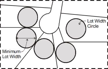
Figure 20.50.030(A): Lot width measurement example.
B. The lot area is the total horizontal land area contained within the boundaries of the lot. The minimum lot area is required to qualify as a building site. (Ord. 581 § 1 (Exh. 1), 2010; Ord. 238 Ch. V § 1(B-2), 2000).
20.50.040 Setbacks – Designation and measurement.
A. The front yard setback is a required distance between the front property line to a building line (line parallel to the front line), measured across the full width of the lot.
Front yard setback on irregular lots or on interior lots fronting on a dead-end private access road shall be designated by the Director.
B. Each lot must contain only one front yard setback and one rear yard setback except lots abutting two or more streets, as illustrated in Figure 20.50.040(C). Lots with two front yards may reduce one of the front yard setbacks by half the setback specified in Table 20.50.020(1). The Director will determine the reduced front yard setback based on the development pattern of adjacent houses and location of lot access.
C. The rear and side yard setbacks shall be defined in relation to the designated front yard setback.
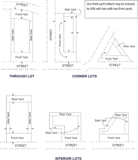 Figure 20.50.040(C): Examples of lots and required yards.
D. The rear yard setback is a required distance from the rear lot line to a line parallel to and measured perpendicularly from the rear lot line. (Rear lot line is the line opposite and/or most distant from the front line.)
E. The side yard setback is a distance measured from any side lot line to a line parallel to that line and that extends from the front yard setback line to the rear yard, front yard (on corner lots), or another side yard setback line.
F. Allowance for Optional Aggregate Setback. For lots with unusual geometry, flag lots with undesignated setbacks, or site conditions, such as critical areas, an existing cluster of significant trees, or other unique natural or historic features that should be preserved without disturbance, the City may reduce the individual required setbacks; however, the total of setbacks shall be no less than the sum of the minimum front yard, rear yard, and side yards setbacks. In order to exercise this option, the City must determine that a public benefit is gained by relaxing any setback standard. The following criteria shall apply:
1. No rear or side yard setback shall be less than five feet.
2. The front yard setback adjacent to the street shall be no less than 15 feet in R-4 and R-6 zones. (See Exception 20.50.070(1).)
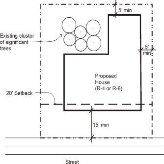
Figure 20.50.040(F): Example of optional aggregate setback to preserve a cluster of significant trees.
G. Setbacks – Adjoining Half-Street or Designated Arterial.
1. In addition to providing the required yard setback, a lot adjoining a half-street or designated arterial shall provide additional width of yard setback sufficient to accommodate construction of the planned half-street or arterial.
H. Setbacks from Regional Utility Corridors.
1. In subdivisions and short subdivisions, areas used as regional utility corridors shall be contained in separate tracts.
2. In other types of land development permits, easements shall be used to delineate such corridors.
3. All buildings and structures shall maintain a minimum distance of five feet from property or easement lines delineating the boundary of regional utility corridors, except for utility structures necessary to the operation of the utility corridor.
I. Projections into Setback.
1. Projections may extend into required yard setbacks as follows, except that no projections shall be allowed into any five-foot yard setback except:
a. Gutters;
b. Fixtures not exceeding three square feet in area (e.g., overflow pipes for sprinkler and hot water tanks, gas and electric meters, alarm systems, and air duct termination; i.e., dryer, bathroom, and kitchens); or
c. On-site drainage systems.
d. Where allowed by the International Building Code and International Fire Code minimum fire separation distance requirements, required yard setback distance from adjacent property lines may be decreased by a maximum of four inches for the sole purpose of adding insulation to the exterior of the existing building structural frame. Existing buildings not conforming to development standards shall not extend into required yard setback more than what would be allowed for a conforming structure under this exception.
e. Rain barrels, cisterns and other rainwater catchment systems may extend into a required yard setback according to the following:
i. Cisterns, rain barrels or other rainwater catchment systems no greater than 600 gallons shall be allowed to encroach into a required yard setback if each cistern is less than four feet wide and less than four and one-half feet tall excluding piping.
ii. Cisterns or rainwater catchment systems larger than 600 gallons may be permitted in required yard setbacks provided that they do not exceed 10 percent coverage in any required yard setback, and they are not located closer than two and one-half feet from a side or rear lot line, or 15 feet from the front lot line. If located in a front yard setback, materials and design must be compatible with the architectural style of the building which it serves, or otherwise adequately screened, as determined by the Director.
iii. Cisterns may not impede requirements for lighting, open space, fire protection or egress.
2. Fireplace structures, bay or garden windows, balconies (including Juliet balconies), enclosed stair landings, closets, or similar structures may project into required setbacks, except into any five-foot yard required setback, provided such projections are:
a. Limited to two per facade;
b. Not wider than 10 feet;
c. Not more than 24 inches into a side yard setback; or
d. Not more than 30 inches into a front and rear yard setback.
3. Eaves shall not project:
a. Into a required five-foot setback;
b. More than 36 inches into front and rear yard required setbacks.
Exception SMC 20.50.040(I)(3): When adjoining a legal, nonconforming eave, a new eave may project up to 20 percent into the required setback or may match the extent of the legal, nonconforming eave, whichever is less. Single-family attached and mixed single-family attached developments subject to Subchapter 3 may have eaves encroach up to 18 inches into a required five-foot setback.
4. Uncovered porches and decks not exceeding 18 inches above the finished grade may project to the front, rear, and side property lines.
5. Uncovered porches and decks, which exceed 18 inches above the finished grade, may project five feet into the required front, rear and side yard setbacks but not within five feet of a property line.
6. Entrances with covered but unenclosed porches may project up to 60 square feet into the front and rear yard setback, but shall not be allowed into any five-foot yard setback.
7. For the purpose of retrofitting an existing residence, uncovered building stairs or ramps no more than 44 inches wide may project to the property line subject to right-of-way sight distance requirements.
8. Landscape structures are allowed in required yard setbacks if they meet the following provisions:
a. No more than a 40-square-foot footprint, including eaves;
b. A maximum height of eight feet;
c. All sides shall be at least 50 percent open, or, if latticework is used, there shall be a minimum opening of two inches between crosspieces;
d. Vegetation supported by a landscape structure may grow over the maximum height, subject to the sight clearance provisions in the Engineering Development Manual.
9. No projections are allowed into a regional utility corridor.
10. No projections are allowed into an access easement. (Ord. 959 § 1 (Exh. A), 2022; Ord. 907 § 1 (Exh. B), 2020; Ord. 871 § 1 (Exh. A), 2020; Ord. 850 § 1 (Exh. A), 2019; Ord. 789 § 1 (Exh. A), 2018; Ord. 767 § 1 (Exh. A), 2017; Ord. 724 § 1 (Exh. A), 2015; Ord. 663 § 1 (Exh. 1), 2013; Ord. 581 § 1 (Exh. 1), 2010; Ord. 515 § 1, 2008; Ord. 469 § 1, 2007; Ord. 352 § 1, 2004; Ord. 299 § 1, 2002; Ord. 238 Ch. V § 1(B-3), 2000).
20.50.050 Building height – Standards.
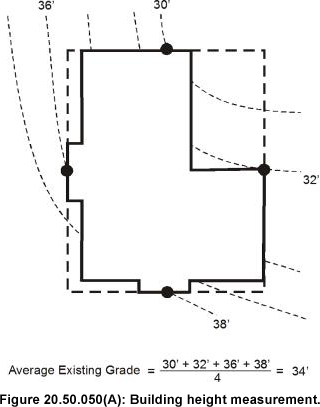
The base height for all structures shall be measured from the average existing grade to the highest point of the roof. The average existing grade shall be determined by first delineating the smallest rectangle which can enclose the building and then averaging the elevations taken at the midpoint of each side of the rectangle; provided, that the measured elevations do not include berms.
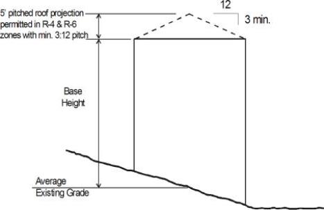
Exception 20.50.050(1): The ridge of a pitched roof on the principal house in R-4 and R-6 zones may extend up to 35 feet; provided, that all parts of the roof above 30 feet must be pitched at a rate of not less than three to 12.
Exception 20.50.050(2): The ridge of a pitched roof on the building in the R-18 through R-48 zones may extend up to 40 feet; provided, that all parts of the roof above 35 feet must be pitched at a rate of not less than four to 12. (For further exceptions to height limits in the R-48 zone, see Exceptions 20.50.020(8) and (9).)
Exception 20.50.050(3): The following structures may be erected above the height limits in residential zones:
• Roof structures housing or screening elevators, stairways, tanks, ventilating fans, or similar equipment required for building operation and maintenance;
• Renewable energy systems such as solar collectors and small scale wind generators are allowed an additional 15 feet above the height limit of the zone when camouflaged to the greatest extent possible;
• Fire or parapet walls, skylights, flagpoles, chimneys, and utility line towers and poles; and
• Steeples, crosses, and spires when integrated as an architectural element of a building.
• The maximum allowable roof height may be increased by eight inches, only for the purpose of adding insulation to the exterior of the existing building structural frame. Existing buildings not conforming to development standards shall not exceed the maximum allowable height limit by more than what would be allowed for a conforming structure under this exception. The Director may prohibit additional roof height encroachments in view-sensitive areas. (Ord. 669 § 1 (Exh. A), 2013; Ord. 663 § 1 (Exh. 1), 2013; Ord. 352 § 1, 2004; Ord. 238 Ch. V § 1(B-4), 2000).
Subchapter 2.
Single-Family Detached Residential Design
20.50.060 Purpose.
The purpose of this subchapter is to establish design standards for single-family detached residential development as follows:
A. To ensure that the physical characteristics of new houses through infill development are compatible with the character and scale of surrounding area, and provide adequate light, air, privacy, and open space for each house.
B. To establish a well-defined single-family residential streetscape by setting back houses for a depth that allows for landscaped front yard.
C. To reduce the visual impact of garages from the street views. (Ord. 238 Ch. V § 2(A), 2000).
20.50.070 Site planning – Front yard setback – Standards.
The front yard setback requirements are specified in Subchapter 1 of this chapter, Dimensions and Density for Development, except as provided for below.
For individual garage or carport units, at least 20 linear feet of driveway shall be provided between any garage, carport entrance and the property line abutting the street, measured along the centerline of the driveway. See SMC 20.50.040(B) for exceptions to lots with two front yards.
Exception 20.50.070(1): The front yard setback may be reduced to the average front setback of the two adjacent lots, provided the applicant demonstrates by survey that the average setback of adjacent houses is less than 20 feet. However, in no case shall an averaged setback of less than 15 feet be allowed.
If the subject lot is a corner lot, the setback may be reduced to the average setback of the lot abutting the proposed house on the same street. The second front yard setback may be reduced by half of the front yard setback established through this provision.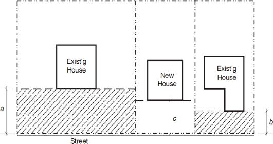
Figure Exception to 20.50.070(1): Minimum front yard setback (c) may be reduced to the average setback of houses located on adjacent lots (a and b).
Calculation: c (min) = (a +b) / 2.
Exception 20.50.070(2): The required front yard setback may be reduced to 15 feet provided there is no curb cut or driveway on the street and vehicle access is from another street or an alley.
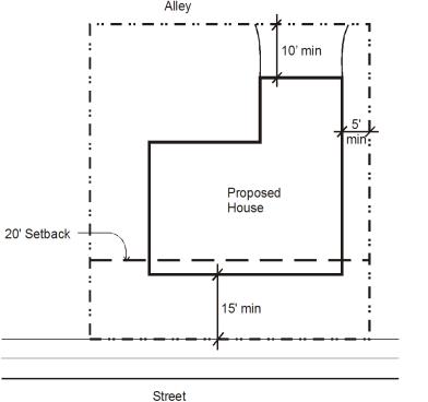
(Ord. 959 § 1 (Exh. A), 2022; Ord. 767 § 1 (Exh. A), 2017; Ord. 515 § 1, 2008; Ord. 299 § 1, 2002; Ord. 238 Ch. V § 2(B-1), 2000).
20.50.080 Site planning – Rear and side yard setbacks – Standards.
A. The rear yard setback requirements are specified in Subchapter 1 of this chapter, Dimensional and Density Standards for Residential Development, except as provided for below.
Exception to 20.50.080(A)(1): If the rear yard faces on an alley, the rear yard may be reduced to 10 feet, provided automobile access is the alley.
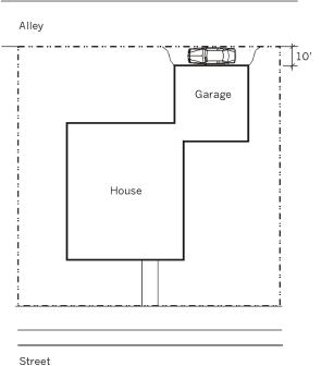
Figure Exception to 20.50.080(A)(1): Setting the garage back 10’ from the alley reduces the garage’s impacts to the street front and allows for parallel parking in front of the garage.
B. Repealed by Ord. 907.
(Ord. 907 § 1 (Exh. A), 2020; Ord. 299 § 1, 2002; Ord. 238 Ch. V § 2(B-2), 2000).
20.50.090 Additions to existing single-family house – Standards.
Repealed by Ord. 767. (Ord. 695 § 1 (Exh. A), 2014; Ord. 238 Ch. V § 2(B-3), 2000).
20.50.100 Location of accessory structures within required yard setbacks – Standards.
A. No accessory structure shall be located within any required setback.
B. Prohibited Structures. Shipping containers are prohibited within any parcel.
Exception 20.50.100(1): One uninhabited freestanding structure less than 10 feet high and 200 square feet in footprint area, such as a storage shed or greenhouse, may be located within the required rear or side yard setback. This structure shall retain a fire separation distance as specified in adopted building codes.
Exception 20.50.100(2): If the accessory structure, which is less than 200 square feet in footprint and less than 10 feet high, is located in the side yard, such structure shall be set back at least five feet further than the house from any street.
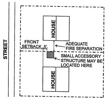 Figure Exception to 20.50.100(2): Permitted location of small accessory structure in side yard.
(Ord. 789 § 1 (Exh. A), 2018; Ord. 406 § 1, 2006; Ord. 238 Ch. V § 2(B-4), 2000).
20.50.110 Fences and walls – Standards.
A. The maximum height of fences located along a property line shall be six feet, subject to the sight clearance provisions in the Engineering Development Manual. (Note: The recommended maximum height of fences and walls located between the front yard building setback line and the front property line is three feet, six inches high.)
B. All electric, razor wire, and barbed wire fences are prohibited.
C. The height of a fence located on a retaining wall shall be measured from the finished grade at the top of the wall to the top of the fence. The overall height of the fence located on the wall shall be a maximum of six feet. (Ord. 767 § 1 (Exh. A), 2017; Ord. 581 § 1 (Exh. 1), 2010; Ord. 406 § 1, 2006; Ord. 299 § 1, 2002; Ord. 238 Ch. V § 2(B-5), 2000).
20.50.115 Lighting – Standards.
A. Light Trespass Standard. Any lighting shall be non-glare and shielded to minimize direct illumination of abutting properties and adjacent streets. All light fixtures shall be located, aimed or shielded so as to minimize stray light trespassing across property lines. The light source (lamp or bulb) in a fixture must be shielded such that the light source is not directly visible from other properties or the public right-of-way.
B. Prohibited Lighting. The following types of lighting are prohibited:
1. Outdoor floodlighting by floodlight projection above the horizontal plane.
2. Search lights, laser source lights, or any similar high intensity light.
3. Any flashing, blinking, rotating or strobe light illumination device located on the exterior of a building or on the inside of a window which is visible beyond the boundaries of the lot or parcel.
Exemptions:
1. Lighting required for emergency response by police, fire, or medical personnel (vehicle lights and accident/crime scene lighting).
2. Lighting in swimming pools and other water features governed by Article 680 of the National Electrical Code.
3. Signs and sign lighting regulated by Chapter 20.50 SMC, Subchapter 8.
4. Holiday and event lighting (except for outdoor searchlights and strobes).
5. Sports and field lighting.
6. Lighting triggered by an automatic emergency or security alarm system.

Examples of Fixtures
(Ord. 663 § 1 (Exh. 1), 2013; Ord. 299 § 1, 2002).
Subchapter 3.
Single-Family Attached Residential Design
20.50.120 Purpose.
The purpose of this subchapter is to establish standards for single-family attached and mixed single-family attached development, excluding lots proposing one duplex building when one unit is located over the other unit, in all zones except R-4, R-6 and neighborhood business (NB). All mixed single-family developments shall meet the design standards contained in this subchapter. Standards that are not addressed in this subchapter will be supplemented by the standards in the remainder of Chapter 20.50 SMC. In the event of a conflict, the standards of this subchapter shall prevail. The purposes of this subchapter are as follows:
A. To encourage development of attractive residential areas that are compatible when considered within the context of the surrounding area.
B. To enhance the aesthetic appeal of new single-family attached buildings by encouraging high quality, creative and innovative site and building design.
C. To meet the recreation needs of project residents by providing open spaces within the project site.
D. To provide safe routes for pedestrians to onsite vehicle parking, building entries, and between buildings.
E. To emphasize quality building articulation, detailing, and durable materials, which add visual interest for pedestrians.
F. Encourage coordinated and functional elements of development, including buildings, landscaping, parking, site access and circulation, and outdoor space. (Ord. 871 § 1 (Exh. A), 2020; Ord. 850 § 1 (Exh. A), 2019; Ord. 756 § 1 (Exh. A), 2016; Ord. 706 § 1 (Exh. A), 2015; Ord. 654 § 1 (Exh. 1), 2013; Ord. 238 Ch. V § 3(A), 2000).
20.50.130 Administrative design review.
Administrative design review approval under SMC 20.30.297 is required for all development applications that propose departures from the design standards contained in this subchapter. (Ord. 871 § 1 (Exh. A), 2020; Ord. 850 § 1 (Exh. A), 2019. Formerly 20.50.122).
20.50.140 Thresholds – Required site improvements.
The purpose of this section is to determine how and when the provisions for full site improvement standards apply to a development application for single-family attached development and mixed single-family attached development. Full site improvement standards for signs, parking, lighting and landscaping shall be required:
A. When building construction valuation for a permit exceeds 50 percent of the current County assessed or an appraised valuation of all existing land and structure(s) on the parcel. This shall include all structures on other parcels if the building under permit review extends into other parcels; or
B. When aggregate building construction valuations for issued permits, within any cumulative five-year period, exceed 50 percent of the County assessed or an appraised value of the existing land and structure(s) at the time of the first issued permit. (Ord. 871 § 1 (Exh. A), 2020; Ord. 756 § 1 (Exh. A), 2016; Ord. 706 § 1 (Exh. A), 2015; Ord. 654 § 1 (Exh. 1), 2013; Ord. 581 § 1 (Exh. 1), 2010; Ord. 515 § 1, 2008; Ord. 299 § 1, 2002. Formerly 20.50.125).
20.50.150 Overlapping standards.
Site design standards for on-site landscaping, walkways, public access easements, and outdoor space may be overlapped if their separate, minimum dimensions and functions are not diminished. (Ord. 871 § 1 (Exh. A), 2020).
20.50.160 Site design – Standards.
A. Setbacks. For developments consisting of three or more units located on a single parcel, the setback shall be 15 feet along any property line abutting R-4 or R-6 zones.
B. Parking.
1. For units with individual garages, at least 20 linear feet of driveway shall be provided between any garage entrance and the property line abutting the public right-of-way, measured along the centerline of the driveway.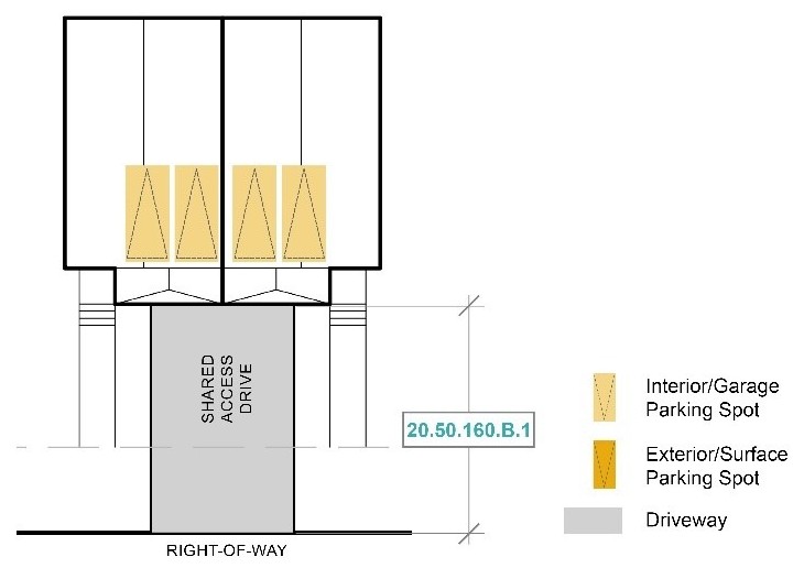
Minimum Linear Distance Illustration
2. Surface parking shall be located behind or to the side of buildings.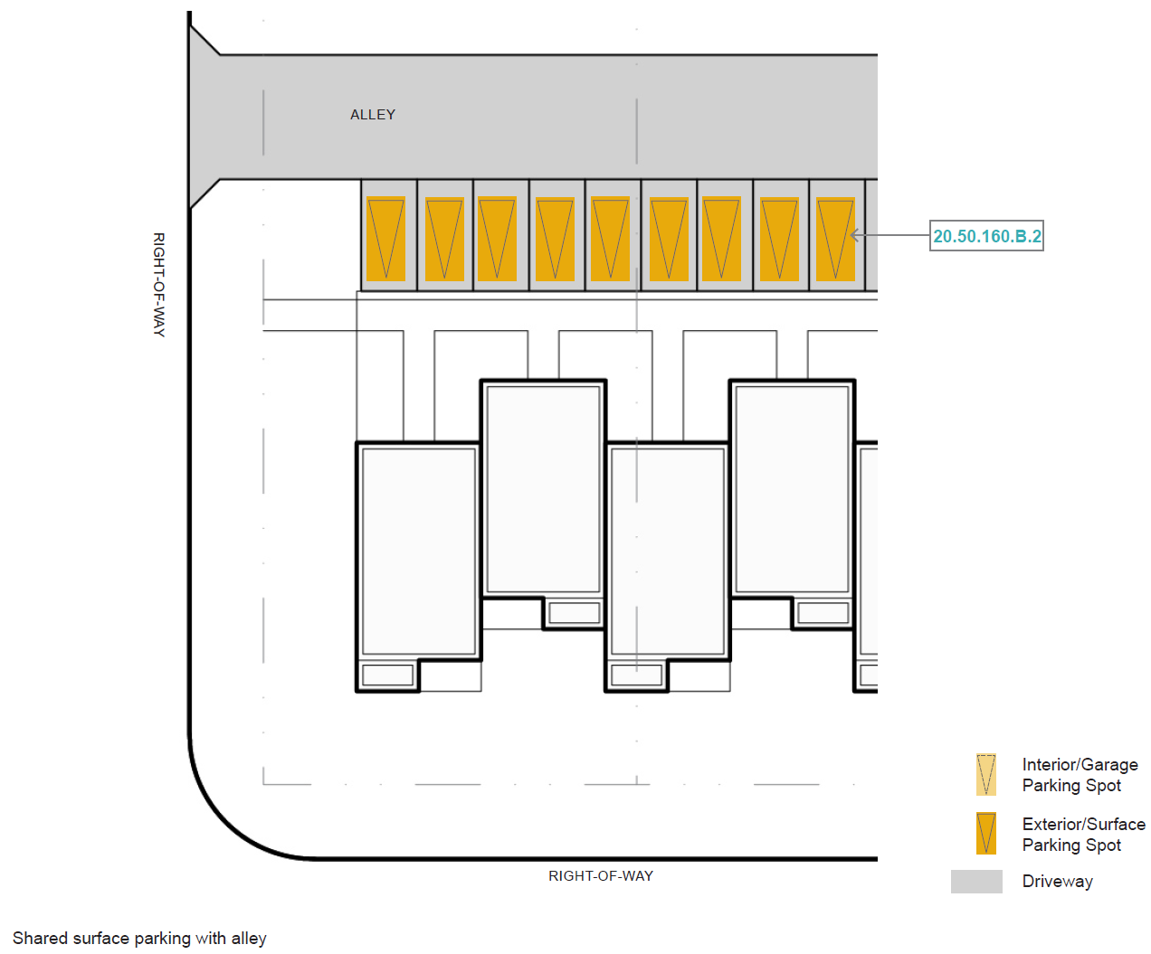
Surface Parking Illustration
3. Carports are prohibited.
C. Site Configuration. At least 40 percent of units within a site shall be located between the front property line and a 25-foot distance from the front property line, with the front facade of the unit(s) oriented towards the public right-of-way, to create a “street wall” which enhances the streetscape and overall pedestrian experience.
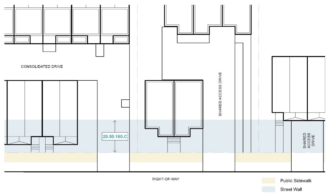
Site Configuration Illustration
D. Site Access and Circulation.
1. Vehicle access requirements are contained in the Engineering Development Manual.
2. On lots with dead-end access drives with a length of 150 feet or greater, measured from the face of curb to the end of the access drive pavement, a turnaround facility shall be provided that meets the standard detail contained in the Engineering Development Manual or, if no standard is provided, the standard detail required by the Public Works Director.
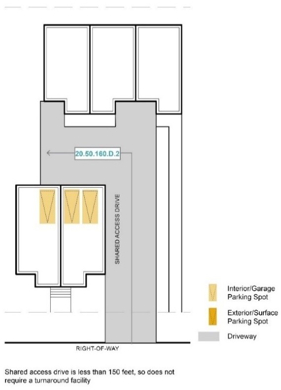
Dead-End Access Drive Illustration 1: Access drive is less than 150 feet, so a turnaround facility is not required.
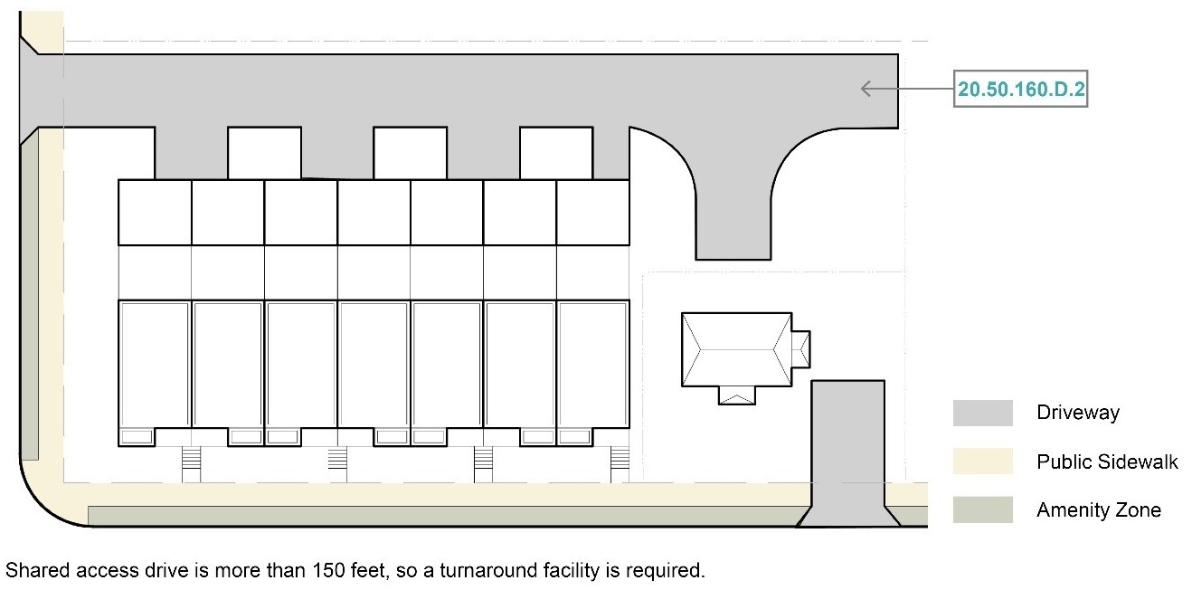
Dead-End Access Drive Illustration 2: Access drive is more than 150 feet, so a turnaround facility is required.
3. If adjoining lots are being developed concurrently, and are under the same ownership, vehicle access points shall be consolidated. This requirement shall not apply to lots that do not have frontage on the same public right-of-way.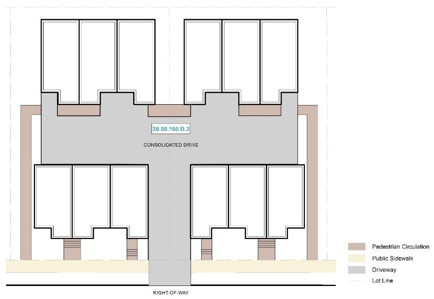
Consolidated Vehicle Access Illustration
4. Each unit shall have on-site pedestrian access to a public sidewalk, and common outdoor space and common parking areas, if provided. For buildings that do not front on the public right(s)-of-way, this requirement shall be considered met if pedestrian access is provided from a public sidewalk to the building(s).
5. On-site pedestrian access shall comply with one of the following:
a. On-site pedestrian access shall be separated from vehicular circulation and a minimum of four feet wide. Separated from vehicular circulation means (i) there is at least five linear feet of landscaping between the closest edge of the vehicular circulation area and closest edge of the pedestrian access or (ii) separation by a building. For buildings that do not front on the public right(s)-of-way, this requirement shall be considered met if pedestrian access is provided from a public sidewalk to the building(s); or
b. Pedestrian access shall be provided through shared-space with on-site vehicle circulation that complies with the following to clearly communicate to all users it is shared-space:
i. Traffic calming elements shall be located on both sides of the shared-space circulation and spaced no more than 25 feet apart. The shared-space circulation shall have at least one of the following elements: trees that meet the minimum replacement tree size per SMC 20.50.360; raised planters a minimum height of three feet and depth and width of two feet; decorative bollards a minimum height of three feet; or any other element the Director determines accomplishes the purpose;
ii. The entire shared-space circulation area shall be constructed with decorative concrete, paving blocks, bricks, or other ornamental paving treatments to clearly indicate the entire surface is intended for pedestrians as well as vehicles;
iii. The shared-space shall relate to the building(s) by having elements that allow for informal surveillance, including doors, windows, porches, stoops and balconies oriented towards the shared circulation space; and
iv. The shared-space circulation shall not result in a dead-end when abutting two or more public rights-of-way. It shall provide through access from one public right-of-way to a second public right-of-way.
Building Relationship to Shared-Space Image
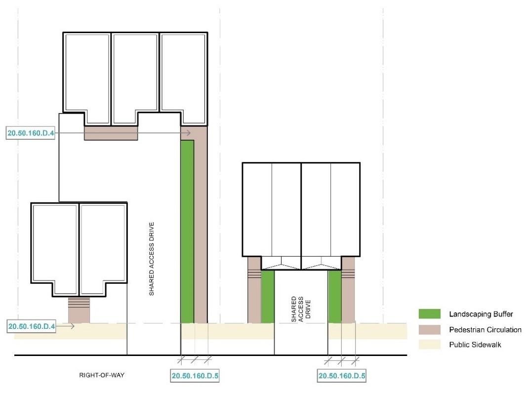
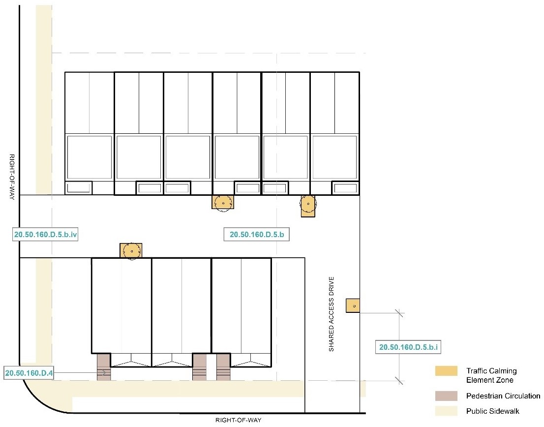
Site Access and Circulation Illustrations
E. Storage Space and Staging Area for the Collection of Solid Waste.
1. Developments with nine or fewer units shall comply with one of the following options for providing solid waste storage space and staging area:
a. If the storage space is provided in individual unit garages, the space shall be its own dedicated area and shall not overlap with space needed for required vehicle parking, and staging areas shall comply with one of the following:
i. Solid waste bins shall be placed in the amenity zone if there is adequate area and placement does not conflict with above-grade infrastructure or services, including, but not limited to, fire hydrants, electrical poles, mailboxes, and street trees; or
ii. Solid waste bins shall be placed within the front setback, provided the area needed to accommodate the bins does not preclude compliance with other codes and standards; or
iii. Solid waste bins shall be placed along one side of the access drive, provided placement does not interfere with vehicular access and circulation, and the City’s solid waste purveyor provides written confirmation it will service the location of the bins.
b. If the storage space and staging area are provided in a common indoor trash room or room(s) or a common outdoor enclosure or enclosure(s), it shall comply with all the following:
i. Access to and maintenance of the trash room(s) or enclosure(s), and financial responsibility, shall be addressed in a covenants, conditions and restrictions document to be recorded prior to development permit issuance;
ii. The City’s solid waste purveyor provides written confirmation it will service the location of the trash room(s); and
iii. If the storage space is provided in an outdoor enclosure or enclosure(s), it shall be completely screened from pedestrian view from the public right(s)-of-way by a solid enclosure such as a fence or wall, or dense landscaping.
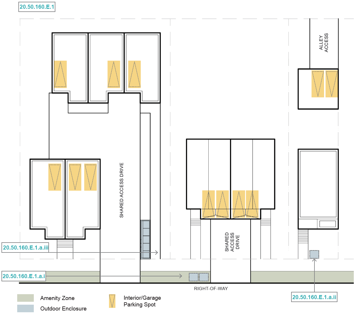
Solid Waste Storage and Staging Area Illustration 1
2. Developments with 10 or more units shall comply with one of the following options for providing solid waste storage space and a staging area:
a. If the storage space is provided in the individual unit garages it shall be its own dedicated area and shall not overlap with space needed for required vehicle parking. Staging areas shall abut vehicle access drives, but shall not obstruct vehicle circulation, and shall comply with one of the following:
i. The vehicle access shall not dead-end, but provide a through connection to a public right-of-way; or
ii. The site shall contain a turnaround that meets the standard detail required by the Public Works Director.
b. If the storage space and staging area is provided in a common indoor trash room or room(s), or in a common outdoor enclosure or enclosure(s), it shall comply with the following:
i. Access to and maintenance of the trash room(s) or enclosure(s), and billing, shall be addressed in a covenants, conditions and restrictions document to be recorded prior to development permit issuance; and
ii. The City’s solid waste purveyor provides written confirmation it will service the location of the trash room(s); and
iii. If the storage space is provided in an outdoor enclosure or enclosure(s), it shall be completely screened.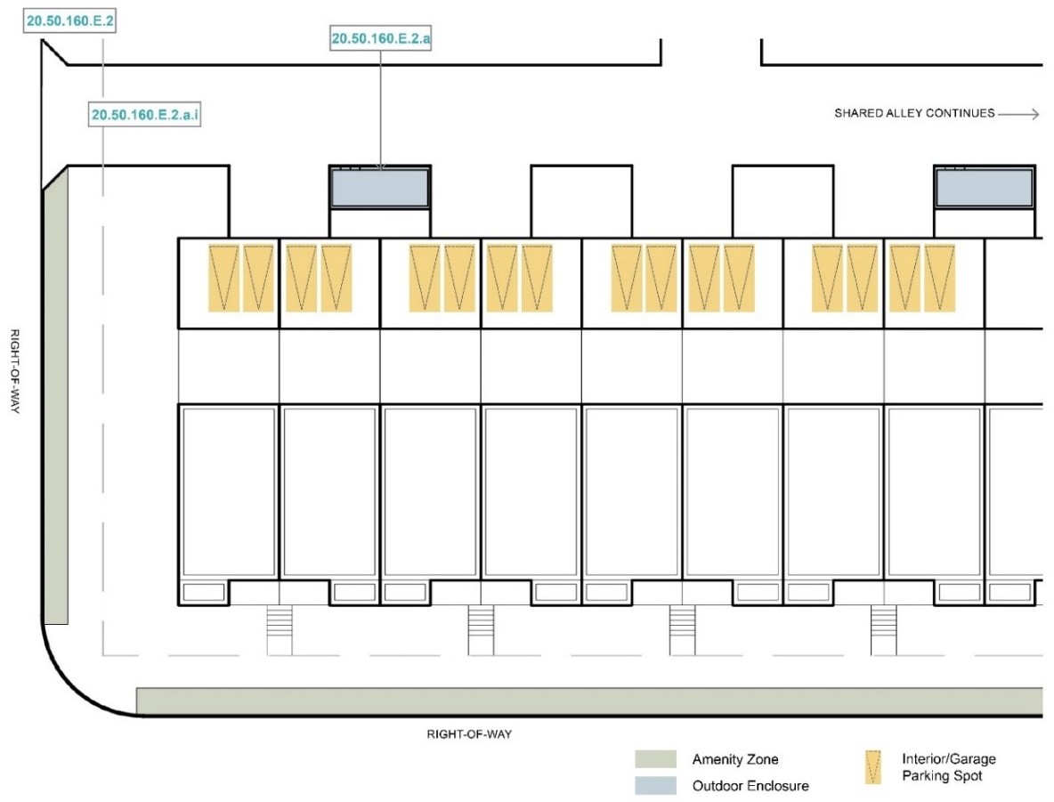
Solid Waste Storage and Staging Area Illustration 2
F. Accessory Structures. Shipping containers are prohibited.
G. Utility and Mechanical Equipment.
1. Mechanical and utility equipment shall be located and designed to minimize its visibility by the public. Preferred locations are off alleys; access drives; within, atop, or under buildings; underground; or other locations away from the public right-of-way. Equipment shall not intrude into required pedestrian areas.
2. Ground-mounted mechanical equipment shall be fully enclosed within an opaque fence or wall, or it shall be screened with dense landscaping from pedestrian view from the public right-of-way. Chain-link fencing with slats is prohibited.
3. All exterior building-mounted mechanical equipment, with the exception of solar collectors or wind power generating equipment, shall be screened from pedestrian view by integration with the building’s architecture through such elements as parapet walls, false roofs, roof wells, clerestories, equipment rooms, materials and colors.
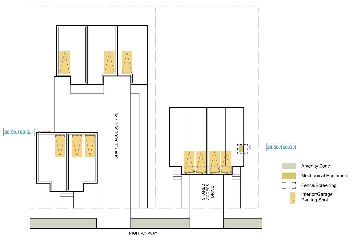
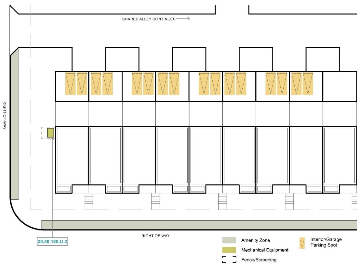
Utility and Mechanical Equipment Illustrations
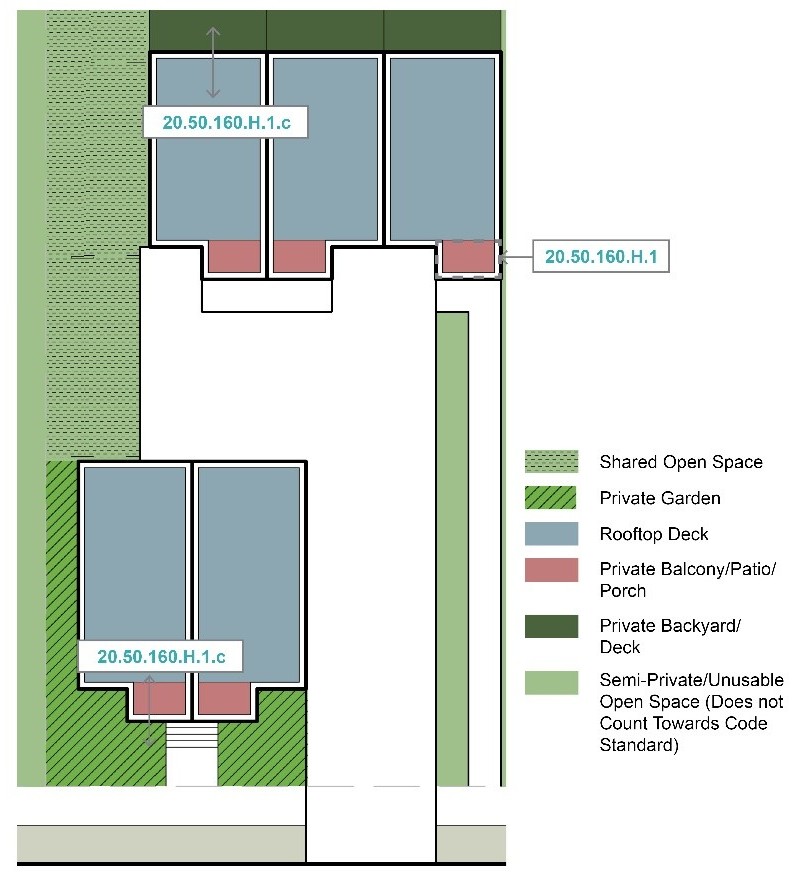
H. Outdoor Space. Developments shall comply with all of the following requirements:
1. Each unit shall have 150 square feet of private outdoor space that complies with all of the following standards:
a. No single outdoor space to be counted as part of this requirement shall be less than 50 square feet with no dimension less than six lineal feet;
b. Private outdoor space includes balconies, patios, decks, porches, gardens, or any other outdoor space that meets the purpose of this section, as approved by the Director; and
c. The private outdoor space shall be directly accessible from the associated unit.
2. Each development shall provide a minimum of 800 square feet or 50 square feet per unit of common outdoor space, whichever is greater, that complies with all of the following standards:
a. No dimension shall be less than 10 lineal feet.
b. Common outdoor space includes rooftop decks, gardens, courtyards, or any other outdoor space that meets the purpose of this section, as approved by the Director.
c. Required landscaping can be utilized to satisfy the outdoor space requirements if all of the following are provided:
i. A minimum of one amenity per 200 square feet is provided along the walkway through the garden/landscaped area, including landscape structures, permanently affixed tables and chairs, benches, and/or fountains;
ii. The landscaped area is connected by a walkway to the rest of the on-site pedestrian walkways; and
iii. Wayfinding signage is provided leading to the common outdoor space, and identification signage is provided at the entrance(s) to the common outdoor space indicating its use (e.g., “This area is common outdoor space to be used by community residents and guests.”)
d. The common outdoor space shall be accessible to all residents of the development.
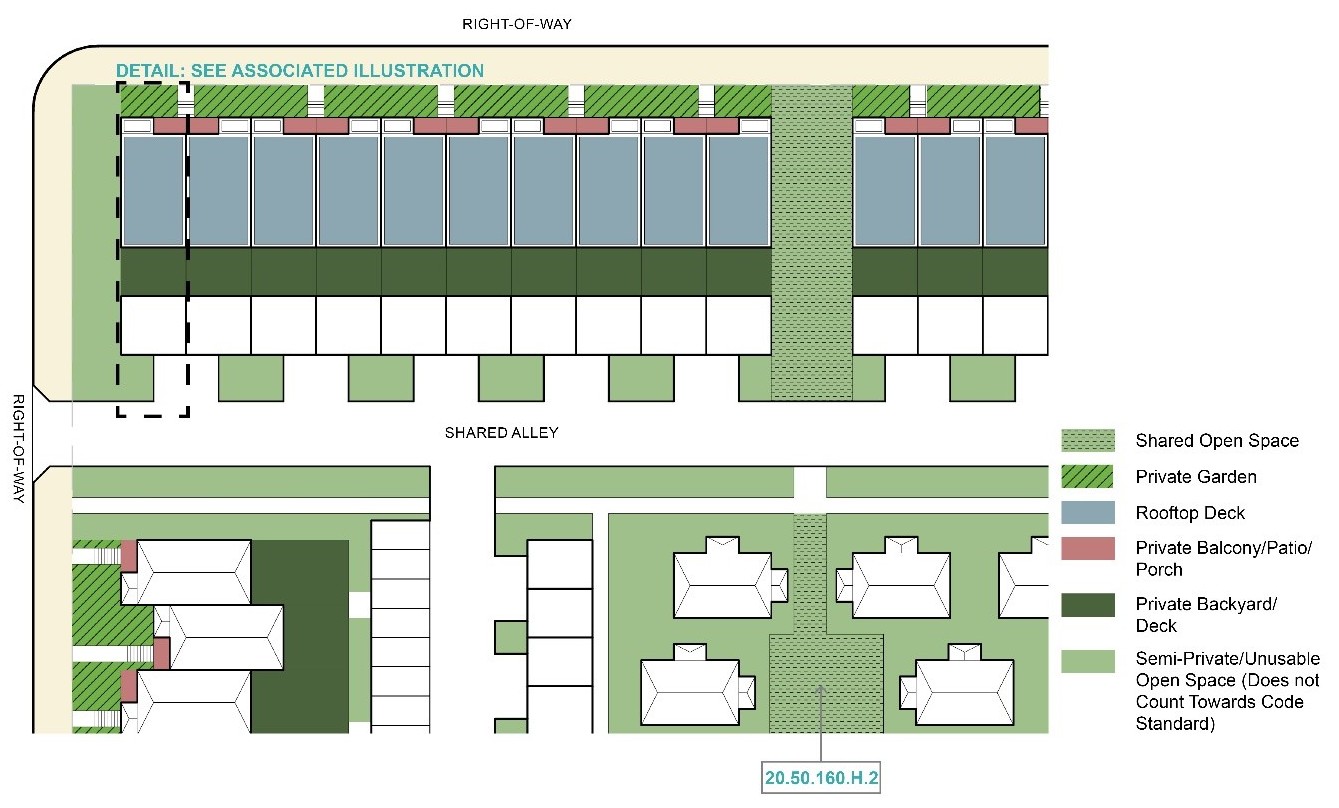
Open Space Illustration 1
Open Space Illustration 2
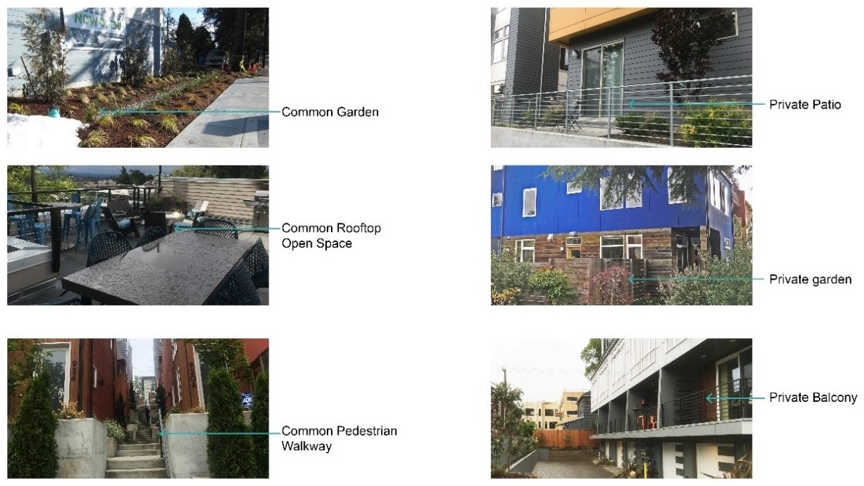
Open Space Images
I. Facade Landscaping. As required by SMC 20.50.485, facade landscaping shall be provided on any building facade facing a public right-of-way. (Ord. 907 § 1 (Exh. B), 2020; Ord. 871 § 1 (Exh. A), 2020; Ord. 850 § 1 (Exh. A), 2019; Ord. 789 § 1 (Exh. A), 2018; Ord. 706 § 1 (Exh. A), 2015; Ord. 555 § 1 (Exh. 1), 2009; Ord. 299 § 1, 2002; Ord. 238 Ch. V §§ 3(B-2) 3(B-3), 2000. Formerly 20.50.140, 20.50.150).
20.50.170 Building design – Standards.
A. Building Orientation.
1. Each unit with right-of-way frontage shall have its primary entry oriented toward the right-of-way.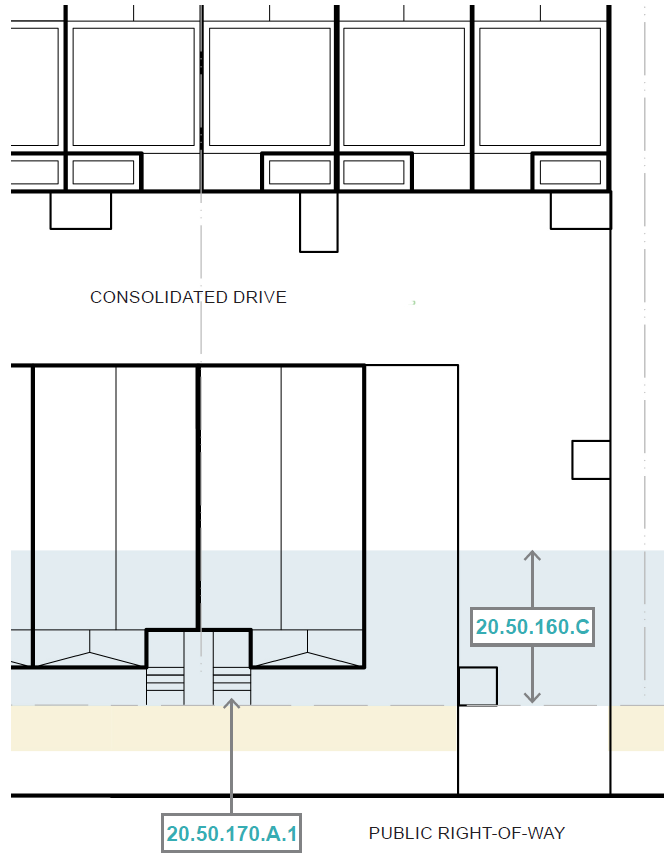
Primary Entry Illustration
2. Buildings with frontage on multiple public rights-of-way are only required to have the primary entry oriented towards one public right-of-way. Which right-of-way the entry shall be oriented towards shall be determined by the Director. The Director shall take into consideration site-specific and project-specific factors such as right-of-way classification, lot orientation and site configuration in making this determination.
B. Building Modulation, Massing and Articulation.
1. Each unit shall have a covered entry or porch with weather protection at least 20 square feet with a minimum width of four feet and minimum depth of three feet.
2. Each building shall incorporate variation by using at least three of the following elements on the front facade:
a. Variations in the setback of the facade of the building by at least four feet between adjoining units;
b. Diminishing upper floors (gross floor area of third story is smaller than the gross floor area of the lower stories). To meet this requirement, the building wall shall be stepped back a minimum of two feet with a minimum width of eight feet. Balconies that are covered but not fully enclosed and meet the minimum dimensions specified shall be considered a diminished upper floor;
c. Changes in roofline at intervals not greater than 40 feet in continuous length, such as variations in roof pitch, overhangs, projections, or extended eaves;
d. Balconies (excluding Juliet balconies) on the facade of the building that have a minimum depth of six feet between the building wall and the balcony railing; at least 50 percent of the units shall have a balcony;
e. Garage door entrance(s) for vehicles located at the side or rear of buildings;
f. Dormers (at least three feet wide); at least 50 percent of the units shall have dormers;
g. Living green wall minimum of 100 square feet;
h. A facade with at least 40 percent fenestration and/or landscaping, 50 percent of which shall be fenestration;
i. Trim that is a minimum of three-quarter inch deep and three and one-half inches wide to mark roof lines, windows, and doors on all public right-of-way facing facades;
j. Other variation techniques that meet the purpose of the section as approved by the Director.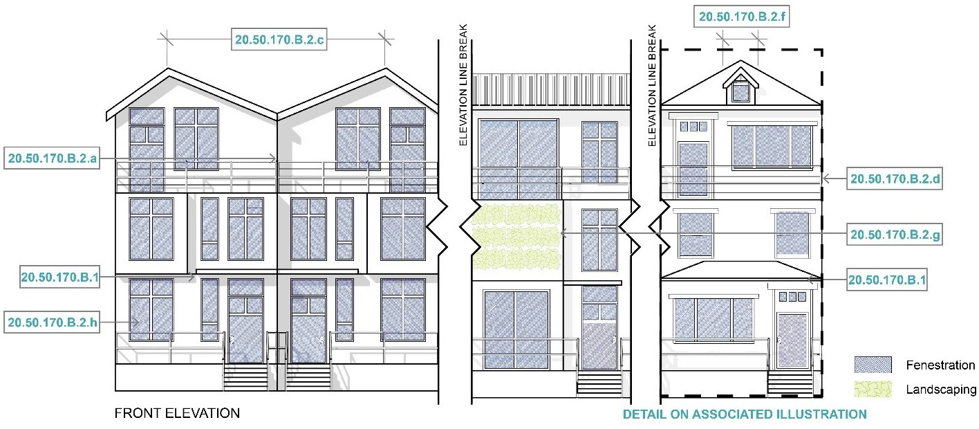
Building Modulation, Massing and Articulation Illustration 1
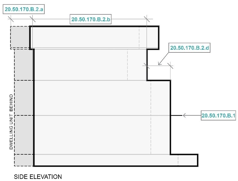
Building Modulation, Massing and Articulation Illustration 2
3. Building Facades. Building facades shall comply with all of the following:
a. Public right-of-way facing facades shall consist of at least 30 percent fenestration and/or landscaping.
b. All other facades shall consist of at least 15 percent fenestration and/or landscaping.
c. The facade area is measured vertically, top to bottom, and horizontally edge-to-edge as illustrated in Illustration 3.
d. For purposes of calculation, the square footage of landscaping shall be measured at the size it will be at installation, not maturity.
e. Blank walls (building facade sections without fenestration or covered by landscaping) greater than 20 feet in length are prohibited.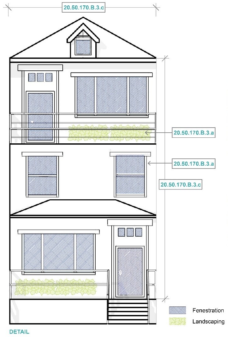
Building Modulation, Massing and Articulation Illustration 3: Illustration of No Blank Facade. The facade facing the right-of-way measures 650 square feet. The facade depicted has 235 square feet of fenestration and landscaping, which is 36 percent of the facade, meeting the requirement.
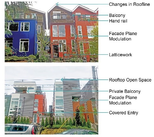
Building Modulation, Massing and Articulation Images
4. Public right-of-way-facing garages shall comply with the following standards:
a. The maximum combined garage door width facing the public right-of-way shall be 50 percent or less of the total building width. If the solid waste storage space is provided within each individual unit garage, then the width in the garage needed to accommodate this storage shall be excluded from the maximum 50 percent calculation;
b. The garage(s) shall be recessed a minimum of one foot behind the front facade; and
c. The access from the public right-of-way shall comply with the requirements of the Engineering Development Manual.
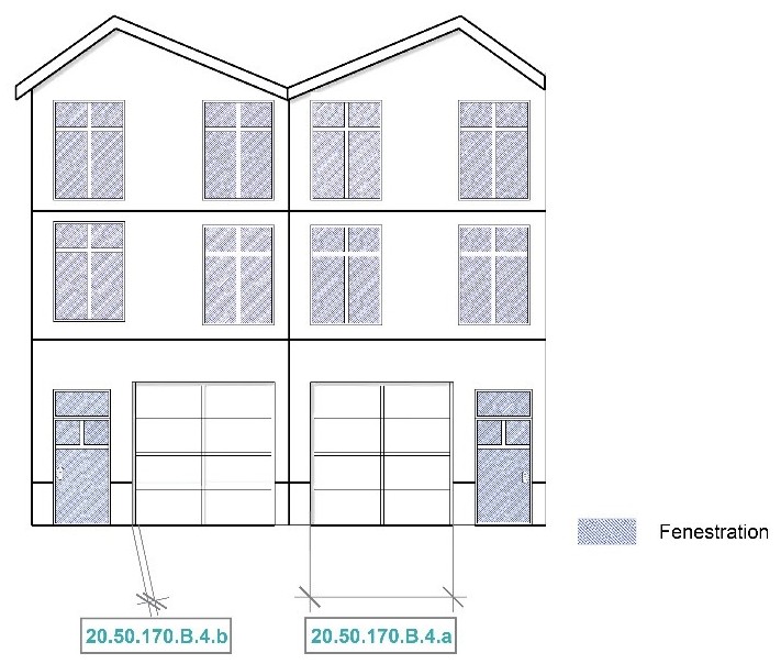
Public Right-of-Way Facing Garage Illustration
C. Building Materials. Materials and colors shall comply with the following:
1. If multiple materials are used in a building facade, the visually heavier materials shall be located below the lighter materials, e.g., brick or stone shall be located below siding materials, unless they are used as architectural features.
2. Architectural elements, such as trim, shall be of a color that provides contrast to the surrounding, dominant material color(s).
3. Insubstantial materials, such as fiberglass, and materials such as mirrored glass and plywood or T-111 siding are prohibited. Uncoated zinc and copper are prohibited.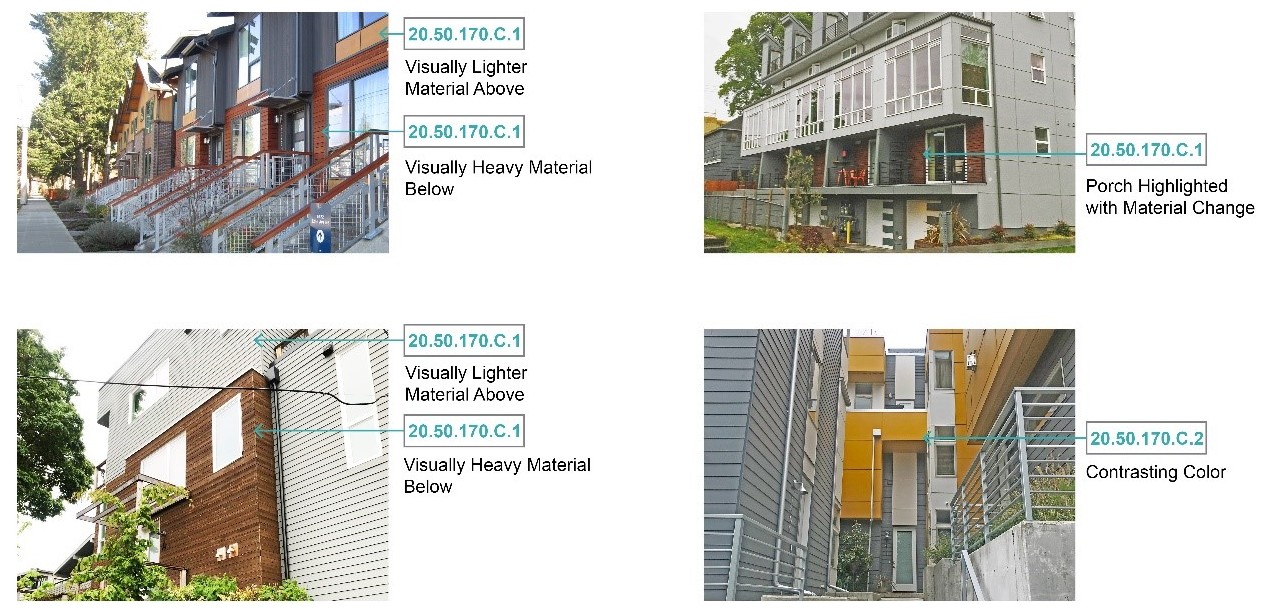
Building Materials Images
(Ord. 871 § 1 (Exh. A), 2020; Ord. 238 Ch. V § 3(C-1), 2000. Formerly 20.50.180).
20.50.180 Outdoor lighting – Standards.
A. Light Trespass Standard. All light sources, such as a lamp or bulb, shall be shielded within a fixture, and fixtures shall be located, aimed or shielded to prevent direct light trespassing across property lines.
B. On-site pedestrian pathways shall be illuminated with at least two foot-candles of light.
C. Building entries shall be illuminated with at least four foot-candles of light.
D. Prohibited Lighting. The following types of lighting are prohibited:
1. Outdoor floodlighting by floodlight projection above the horizontal plane;
2. Search lights, laser source lights, or any similar high intensity light; and
3. Any flashing, blinking, rotating or strobe light illumination device located on the exterior of a building or on the inside of a window which is visible beyond the boundaries of the lot.
Exemptions:
1. Lighting in swimming pools and other water features governed by Section 321 (Lighting) of the International Swimming Pool and Spa Code, or Chapter 246-260 WAC, as applicable.
2. Signs and sign lighting regulated by Chapter 20.50 SMC, Subchapter 8.
3. Holiday and event lighting (except for outdoor searchlights and strobes).
4. Lighting triggered by an automatic emergency or security alarm system.
(Ord. 871 § 1 (Exh. A), 2020; Ord. 663 § 1 (Exh. 1), 2013. Formerly 20.50.205).
20.50.190 Fences and walls – Standards.
A. Front Yard. Fences and walls located within the required minimum front yard setback shall be a maximum of three feet, six inches high and shall be no more than 60 percent opaque.
B. Side and Rear Yards. The maximum height of fences located along a side and/or rear yard property line shall be six feet.
C. Fences and walls shall be constructed of wood, wrought iron, brick, stone, or other high quality material. All chain link, electric, razor wire, and barbed wire fences, and other similar types of security fences are prohibited.
D. The height of a fence located on a retaining wall shall be measured from the finished grade at the top of the wall to the top of the fence. The overall height of the fence located on the wall shall be a maximum of six feet. (Ord. 871 § 1 (Exh. A), 2020; Ord. 406 § 1, 2006; Ord. 299 § 1, 2002; Ord. 238 Ch. V § 3(C-4), 2000. Formerly 20.50.210).
Subchapter 4.
Commercial and Multifamily Zone Design
20.50.220 Purpose.
The purpose of this subchapter is to establish design standards for all commercial zones – neighborhood business (NB), community business (CB), mixed business (MB) and town center (TC-1, 2 and 3). This subchapter also applies to the MUR-35' and the MUR-45' zones for all uses except single-family attached and mixed single-family developments; and the MUR-70' zone, R-8, R-12, R-18, R-24, R-48, PA 3 and TC-4 zones for commercial and multifamily uses. Refer to SMC 20.50.120 when developing single-family attached and detached dwellings in the MUR-35' and MUR-45' zones. Some standards within this subchapter apply only to specific types of development and zones as noted. Standards that are not addressed in this subchapter will be supplemented by the standards in the remainder of this chapter. In the event of a conflict, the standards of this subchapter shall prevail. (Ord. 959 § 1 (Exh. A), 2022; Ord. 901 § 1 (Exh. A), 2020; Ord. 871 § 1 (Exh. A), 2020; Ord. 756 § 1 (Exh. A), 2016; Ord. 706 § 1 (Exh. A), 2015; Ord. 654 § 1 (Exh. 1), 2013).
20.50.225 Administrative design review.
Administrative design review approval under SMC 20.30.297 is required for all development applications that propose departures from the design standards in this subchapter or sign standards in Chapter 20.50 SMC, Subchapter 8. (Ord. 901 § 1 (Exh. A), 2020; Ord. 871 § 1 (Exh. A), 2020; Ord. 654 § 1 (Exh. 1), 2013).
20.50.230 Threshold – Required site improvements.
The purpose of this section is to determine how and when the provisions for site improvements cited in the General Development Standards apply to development proposals. Full site improvement standards apply to a development application in commercial zones NB, CB, MB, TC-1, 2 and 3, and the MUR-70' zone. This subsection also applies in the following zoning districts except for the single-family attached use: MUR-35', MUR-45', PA 3, and R-8 through R-48. Full site improvement standards for signs, parking, lighting, and landscaping shall be required:
A. When building construction valuation for a permit exceeds 50 percent of the current county assessed or an appraised valuation of all existing land and structure(s) on the parcel. This shall include all structures on other parcels if the building under permit review extends into other parcels; or
B. When aggregate building construction valuations for issued permits, within any cumulative five-year period, exceed 50 percent of the county assessed or an appraised value of the existing land and structure(s) at the time of the first issued permit.
C. When a single-family land use is being converted to a commercial land use then full site improvements shall be required.
D. Commercial Adaptive Reuse. When an existing building was previously used as a legally established commercial use and is proposed to be reused as a commercial use, then site improvements may be waived based on the following conditions:
1. The following list of uses may qualify to be exempt from the required site improvement thresholds in subsections A and B of this section:
a. Theater.
b. Health/fitness club.
c. Daycare.
d. Professional office.
e. Medical office.
f. Veterinary clinics.
g. General retail trade and services.
h. Market.
i. Eating and drinking establishments.
j. Brewpub/microbrewery/microdistillery.
2. The proposed use will not cause significant noise to adjacent neighbors.
3. No expansion of the building is allowed.
4. No new signs facing abutting residential uses.
5. Landscape buffers will be installed between parking spaces and/or drive aisles and abutting residential uses. If no room exists to provide a landscape buffer, then an opaque fence or wall can be provided as a buffer.
6. No building or site lighting shall shine on adjacent properties.
7. Administrative Design Review. Administrative design review approval under SMC 20.30.297 is required for all development applications that propose departures from the parking standards in Subchapter 6 of this chapter, landscaping standards in Subchapter 7 of this chapter, or sign standards in Subchapter 8 of this chapter. (Ord. 959 § 1 (Exh. A), 2022; Ord. 901 § 1 (Exh. A), 2020; Ord. 871 § 1 (Exh. A), 2020; Ord. 756 § 1 (Exh. A), 2016; Ord. 706 § 1 (Exh. A), 2015; Ord. 654 § 1 (Exh. 1), 2013).
20.50.233 Threshold – Required building design.*
The purpose of this section is to establish thresholds for the application of building design standards set forth in this chapter to development proposals in multifamily commercial and mixed-use residential zones.
A. Building design shall be required:
1. When building construction valuation for a permit exceeds 50 percent of the current county assessed or an appraised valuation of all existing land and structure(s) on the parcel. This shall include all structures on other parcels if the building under permit review extends into other parcels; or
2. When aggregate building construction valuations for issued permits, within any consecutive five-year period, exceed 50 percent of the county assessed or an appraised value of the existing land and structure(s) at the time of the first issued permit. (Ord. 907 § 1 (Exh. C), 2020).
*Code reviser’s note: Ordinance No. 907 adds the provisions of this section as 20.50.235. The section has been editorially renumbered to prevent duplication of numbering.
20.50.235 Site planning – Setbacks – Standards.
For developments consisting of three or more units located on a single parcel in the TC-4 zone, the R-8 through R-48 zones, and the MUR-35', MUR-45' and MUR-70' zones, the setback shall be 15 feet along any property line abutting R-4 or R-6 zones. (Ord. 901 § 1 (Exh. A), 2020; Ord. 871 § 1 (Exh. A), 2020).
20.50.240 Site design.
A. Purpose.
1. Promote and enhance public walking and gathering with attractive and connected development.
2. Promote distinctive design features at high visibility street corners.
3. Provide safe routes for pedestrians and people with disabilities across parking lots, to building entries, and between buildings.
4. Promote economic development that is consistent with the function and purpose of permitted uses and reflects the vision for commercial development as expressed in the Comprehensive Plan.
B. Overlapping Standards. Site design standards for on-site landscaping, sidewalks, walkways, public access easements, public places, and open space may be overlapped if their separate, minimum dimensions and functions are not diminished.
C. Site Frontage.
1. Development in NB, CB, MB, TC-1, 2 and 3, the MUR-45' and MUR-70' zones and the MUR-35' zone when located on an arterial street shall meet the following standards:
a. Buildings and parking structures shall be placed at the property line or abutting public sidewalks, except when the required minimum front yard setback is greater than zero feet, in which case the building shall be placed at the minimum setback. However, buildings may be set back farther if public places, landscaping and vehicle display areas are included or future right-of-way widening or a utility easement is required between the sidewalk and the building;
b. All building facades in the MUR-70' zone fronting on any street shall be stepped back a minimum of 10 feet for that portion of the building above 45 feet in height. Reference dimensional Table 20.50.020(2) and exceptions;
c. For properties not subject to SMC 20.40.465, the minimum height of ground floor nonresidential space abutting streets shall be 15 feet, measured from finished floor to finished floor, the minimum depth shall be 20 feet, and it shall be built to commercial building code. This requirement does not apply when developing a residential-only building in the MUR-35' and MUR-45' zones;
d. Transparency. Buildings shall comply with the following:
i. Transparent window area, including glass entry doors, shall occupy a minimum of 60 percent of the ground floor facade as measured between a height of 30 inches and eight feet, where abutting principal, minor, and collector arterials, as mapped in the Transportation Master Plan. This requirement does not apply when developing a residential-only building in the MUR-35' and MUR-45' zones. The following exception applies:
On lots up to 100 feet in width, as measured where the lot abuts the right-of-way, and where no other feasible vehicle access point exists, the width of the vehicle access drive may be excluded from the ground floor facade lineal frontage for the purposes of calculating the 60 percent minimum transparent window area.
ii. Transparent window area, including glass entry doors, shall occupy a minimum of 45 percent of the ground floor facade as measured between a height of 30 inches and eight feet, where abutting streets not designated as principal, minor, or collector arterials, as mapped in the Transportation Master Plan. This requirement does not apply when developing a residential-only building in the MUR-35' and MUR-45' zones. The following exception applies:
On lots up to 100 feet in width, as measured where the lot abuts the right-of-way, and where no other feasible vehicle access point exists, the width of the vehicle access drive may be excluded from the ground floor facade lineal frontage for the purposes of calculating the 45 percent minimum transparent window area.
e. A building’s primary entry shall be located on a street frontage and recessed to prevent door swings over sidewalks, or an entry to an interior plaza or courtyard from which building entries are accessible;
f. Minimum weather protection shall be provided at least five feet in depth, nine-foot height clearance, and along 80 percent of the facade where over pedestrian facilities. Awnings may project into public rights-of-way, subject to city approval;
g. Streets with on-street parking shall have sidewalks to back of the curb and street trees in pits under grates or at least a two-foot-wide walkway between the back of curb and an amenity strip if space is available. Streets without on-street parking shall have landscaped amenity strips with street trees;
h. Surface parking along street frontages in commercial zones shall not occupy more than 65 lineal feet of the site frontage. Parking lots shall not be located at street corners. No parking or vehicle circulation is allowed between the rights-of-way and the building front facade. See SMC 20.50.470 for parking lot landscape standards;
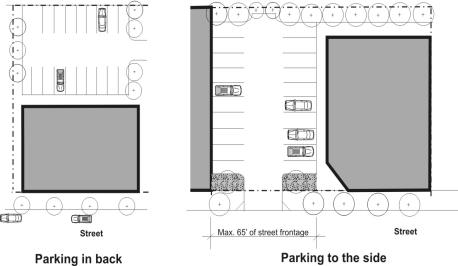
Parking Lot Locations Along Streets
i. New development in MUR zones on 185th Street, 145th Street, and 5th Avenue NE between NE 145th Street and NE 148th Street shall provide all vehicular access from an existing, adjoining public side street or public/private alley. If new development is unable to gain access from an existing, adjoining public side street or public/private alley, an applicant may provide access from the adjacent right-of-way; and
j. Garages and/or parking areas for new development on 185th Street shall be rear-loaded.
D. Corner Sites.
1. All building and parking structures located on street corners (except in MUR-35') shall include at least one of the following design treatments on both sides of the corner:
a. Locate a building within 15 feet of the street corner. All such buildings shall comply with building corner standards in subsection (D)(2) of this section;
b. Provide a public place at the corner leading directly to building entries;
c. Install 20 feet of depth of Type II landscaping for the entire length of the required building frontage;
d. Include a separate, pedestrian structure on the corner that provides weather protection or site entry. The structure may be used for signage.
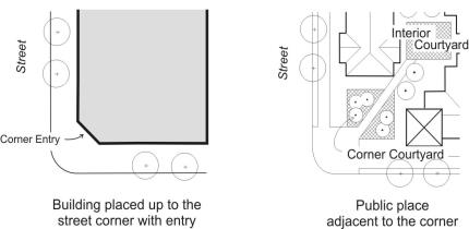
Street Corner Sites
2. Corner buildings and parking structures using the option in subsection (D)(1)(a) of this section shall provide at least one of the elements listed below to 40 lineal feet of both sides from the corner:
a. Twenty-foot beveled building corner with entry and 60 percent of the first floor in non-reflective glass (included within the 80 lineal feet of corner treatment).
b. Distinctive facade (i.e., awnings, materials, offsets) and roofline designs beyond the minimum standards identified in SMC 20.50.250.
c. Balconies for residential units on all floors above the ground floor.
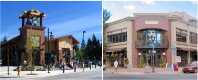
Building Corners
E. Internal Site Walkways.
1. Developments shall include internal walkways or pathways that connect building entries, public places, and parking areas with other nonmotorized facilities including adjacent street sidewalks and Interurban Trail where adjacent (except in the MUR-35' zone).
a. All development shall provide clear and illuminated pathways between the main building entrance and a public sidewalk. Pathways shall be separated from motor vehicles or raised six inches and be at least eight feet wide. “Separated from motor vehicle traffic” means (i) there are at least three linear feet of landscaping between the closest edge of the vehicular circulation area and closest edge of the pedestrian access or (ii) separation by a building;
b. Continuous pedestrian walkways shall be provided along the front of all businesses and the entries of multiple commercial buildings;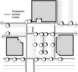
Well-connected Walkways
c. Raised walkways at least eight feet wide shall be provided for every three double-loaded aisles or every 200 feet of parking area width. Walkway crossings shall be raised a minimum three inches above drive surfaces;
d. Walkways shall conform to the Americans with Disabilities Act (ADA);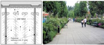
Parking Lot Walkway
e. Deciduous, street-rated trees, as required by the Shoreline Engineering Development Manual, shall be provided every 30 feet on average in grated tree pits if the walkway is eight feet wide or in planting beds if walkway is greater than eight feet wide. Pedestrian-scaled lighting shall be provided per subsection (H)(1)(b) of this section.
F. Public Places.
1. Public places are required for the commercial portions of development at a rate of four square feet of public place per 20 square feet of net commercial floor area up to a public place maximum of 5,000 square feet. This requirement may be divided into smaller public places with a minimum 400 square feet each.
2. Public places may be covered but not enclosed unless by subsection (F)(3) of this section.
3. Buildings shall border at least one side of the public place.
4. Eighty percent of the area shall provide surfaces for people to stand or sit.
5. No lineal dimension is less than six feet.
6. The following design elements are also required for public places:
a. Physically accessible and visible from the public sidewalks, walkways, or through-connections;
b. Pedestrian access to abutting buildings;
c. Pedestrian-scaled lighting (subsection H of this section);
d. Seating and landscaping with solar access at least a portion of the day;
e. Not located adjacent to dumpsters or loading areas; and
f. Amenities such as public art, planters, fountains, interactive public amenities, hanging baskets, irrigation, decorative light fixtures, decorative paving and walkway treatments, and other items that provide a pleasant pedestrian experience along arterial streets.
g. Accessible potable water and electrical power shall be supplied to a public facing portion of the exterior of high-capacity transit centers, stations and associated parking.
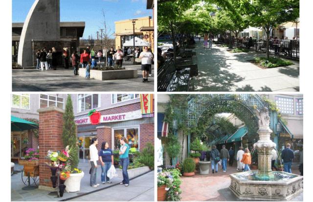
Public Places
G. Multifamily Open Space.
1. All multifamily development shall provide open space.
a. Provide 800 square feet per development or 50 square feet of open space per dwelling unit, whichever is greater;
b. Other than private balconies or patios, open space shall be accessible to all residents and include a minimum lineal dimension of six feet. This standard applies to all open spaces including parks, playgrounds, rooftop decks and ground-floor courtyards; and may also be used to meet walkway standards as long as the function and minimum dimensions of the open space are met;
c. Required landscaping can be used for open space if it does not obstruct access or reduce the overall landscape standard. Open spaces shall not be placed adjacent to service areas without full screening; and
d. Open space shall provide seating that has solar access at least a portion of the day.
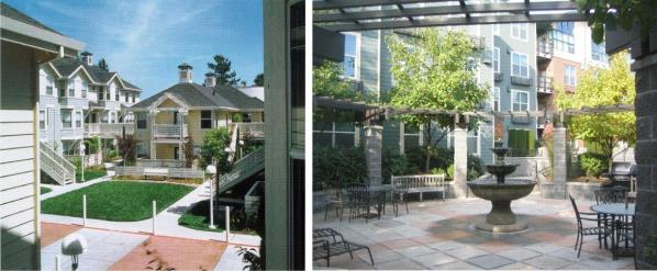
Multifamily Open Spaces
H. Outdoor Lighting.
1. All publicly accessible areas on private property shall be illuminated as follows:
a. Minimum of one-half footcandle and maximum 25-foot pole height for vehicle areas;
b. One to two footcandles and maximum 15-foot pole height for pedestrian areas; and
c. Maximum of four footcandles for building entries with the fixtures placed below second floor.
2. All private fixtures shall be shielded to prevent direct light from entering neighboring property.
3. Prohibited Lighting. The following types of lighting are prohibited:
a. Mercury vapor luminaires.
b. Outdoor floodlighting by floodlight projection above the horizontal plane.
c. Search lights, laser source lights, or any similar high intensity light.
d. Any flashing, blinking, rotating or strobe light illumination device located on the exterior of a building or on the inside of a window which is visible beyond the boundaries of the lot or parcel.
Exemptions:
1. Lighting required for emergency response by police, fire, or medical personnel (vehicle lights and accident/crime scene lighting).
2. Lighting in swimming pools and other water features governed by Article 680 of the National Electrical Code.
3. Signs and sign lighting regulated by Chapter 20.50 SMC, Subchapter 8.
4. Holiday and event lighting (except for outdoor searchlights or strobes).
5. Sports and field lighting.
6. Lighting triggered by an automatic emergency or security alarm system.
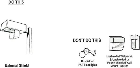
I. Service Areas.
1. All developments shall provide a designated location for trash, composting, recycling storage and collection, and shipping containers. Such elements shall meet the following standards:
a. Located to minimize visual, noise, odor, and physical impacts to pedestrians and residents;
b. Paved with concrete and screened with materials or colors that match the building;
c. Located and configured so that the enclosure gate swing does not obstruct pedestrian or vehicle traffic, nor require a hauling truck to project into public rights-of-way; and
d. Refuse bins shall not be visible from the street.

Trash/Recycling Closure with Consistent Use of Materials and Landscape Screening
J. Utility and Mechanical Equipment.
1. Equipment shall be located and designed to minimize its visibility to the public. Preferred locations are off alleys; service drives; within, atop, or under buildings; or other locations away from the street. Equipment shall not intrude into required pedestrian areas.
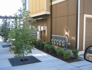
Utilities Consolidated and Separated by Landscaping Elements
2. All exterior mechanical equipment, with the exception of solar collectors or wind power generating equipment, shall be screened from view by integration with the building’s architecture through such elements as parapet walls, false roofs, roof wells, clerestories, equipment rooms, materials and colors. Painting mechanical equipment strictly as a means of screening is not permitted. (Ord. 1000 § 1 (Exh. A), 2023; Ord. 907 § 1 (Exh. B), 2020; Ord. 901 § 1 (Exh. A), 2020; Ord. 850 § 1 (Exh. A), 2019; Ord. 789 § 1 (Exh. A), 2018; Ord. 767 § 1 (Exh. A), 2017; Ord. 756 § 1 (Exh. A), 2016; Ord. 741 § 1 (Exh. A), 2016; Ord. 731 § 1 (Exh. A), 2015; Ord. 706 § 1 (Exh. A), 2015; Ord. 695 § 1 (Exh. A), 2014; Ord. 663 § 1 (Exh. 1), 2013; Ord. 654 § 1 (Exh. 1), 2013).
20.50.250 Building design.
A. Purpose.
1. Emphasize quality building articulation, detailing, and durable materials.
2. Reduce the apparent scale of buildings and add visual interest for the pedestrian experience.
3. Facilitate design that is responsive to the commercial and retail attributes of existing and permitted uses.
4. Create an active and inviting space for pedestrians, with visually interesting storefronts and seamless transitions between public rights-of-way and private space.
B. Building Articulation.
1. Commercial buildings fronting streets other than state routes shall include one of the two articulation features set forth in subsections (B)(2)(a) and (b) of this section facing a street, parking lot, or public place. Parking structure facades fronting public streets shall apply to this subsection only as material, color, texture, or opening modulations and not as offset modulations. Building facades less than 60 feet wide are exempt from this standard.
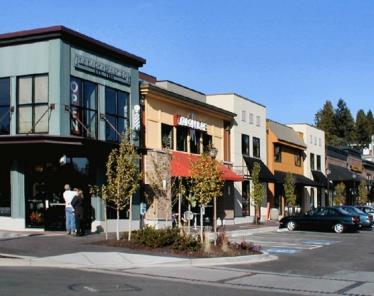
Building Facade Articulation
2. Commercial buildings fronting streets that are state routes shall include one of the two articulation features below no more than every 80 lineal feet facing a street, parking lot, or public place. Building facades less than 100 feet wide are exempt from this standard. Parking structure facades fronting public streets shall apply to this subsection only as material, color, texture, or opening modulations and not as offset modulations.
a. For the height of the building, each facade shall be offset at least two feet in depth and four feet in width, if combined with a change in siding materials. Otherwise, the facade offset shall be at least 10 feet deep and 15 feet wide.
b. Vertical piers at the ends of each facade section that project at least two inches from the facade and extend from the ground to the roofline.
3. Multifamily buildings or residential portions of a commercial building shall provide the following articulation features at least every 35 feet of facade facing a street, park, public place, or open space. Parking structure facades fronting public streets shall apply to this subsection only as material, color, texture, or opening modulations and not as offset modulations:
a. Vertical building modulation 18 inches deep and four feet wide, if combined with a change in color or building material. Otherwise, the minimum depth of modulation is 10 feet and the minimum width for each modulation is 15 feet. Balconies may be used to meet modulation; and
b. Distinctive ground or first floor facade, consistent articulation of middle floors, and a distinctive roofline or articulate on 35-foot intervals.
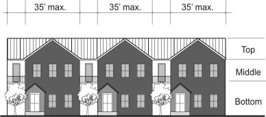
Multifamily Building Articulation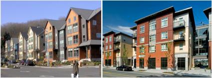
Multifamily Building Articulation
4. Rooflines shall be modulated at least every 120 feet by emphasizing dormers, chimneys, stepped roofs, gables, or prominent cornices or walls. Rooftop appurtenances may be considered a modulation. Modulation shall consist of a roofline elevation change of at least four feet every 50 feet of roofline.
5. Every 150 feet in building length along the streetfront shall have a minimum 30-foot-wide section that is offset by at least 20 feet through all floors.
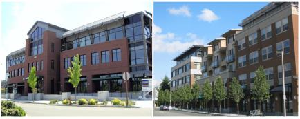
Facade Widths Using a Combination of Facade Modulation, Articulation, and Window Design
6. Buildings shall recess or project individual windows above the ground floor at least two inches from the facade or use window trim at least four inches in width.
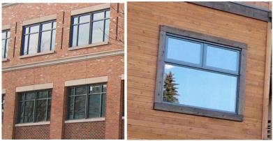
Window Trim Design
7. Weather protection of at least three feet deep by four feet wide is required over each secondary entry.
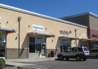
Covered Secondary Public Access
8. Materials.
a. Metal siding shall have visible corner moldings or trim and shall not extend lower than four feet above grade. Masonry, concrete, or other durable material shall be incorporated between the siding and the grade. Metal siding shall be factory finished with a matte, nonreflective surface.
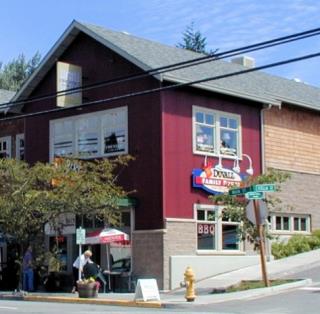
Masonry or Concrete Near the Ground and Proper Trimming Around Windows and Corners
b. Concrete blocks of a singular style, texture, or color shall not comprise more than 50 percent of a facade facing a street or public space.
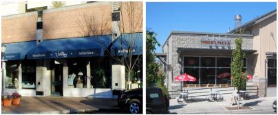
c. Stucco must be trimmed and sheltered from weather by roof overhangs or other methods and shall be limited to no more than 50 percent of facades containing an entry. Stucco shall not extend below two feet above the grade.
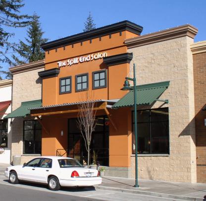
d. The following exterior materials are prohibited:
i. Chain-link fencing that is not screened from public view. No razor or barbed material shall be allowed;
ii. Corrugated, fiberglass sheet products; and
iii. Plywood siding.
C. Ground Floor Nonresidential.
1. New buildings subject to SMC 20.40.465 and 20.50.020(A)(11)(b) shall comply with these provisions.
2. These requirements apply to the portion of the building’s ground floor abutting a public right-of-way (ROW).
3. Required Amount of Nonresidential Space.
a. A minimum of 75 percent of the lineal frontage abutting principal, minor, and collector Arterials, as mapped in the Transportation Master Plan, shall consist of nonresidential space. Up to 25 percent of the lineal frontage may consist of facilities associated with the multifamily use, such as lobbies, leasing offices, fitness centers and community rooms. The following exception applies:
On lots up to 100 feet in width, as measured where the lot abuts the right-of-way, and where no other feasible vehicle access point exists, the width of the vehicle access drive may be excluded from the lineal frontage for the purposes of calculating the 75 percent minimum nonresidential frontage.
b. A minimum of 60 percent of the lineal frontage abutting streets not designated as principal, minor, or collector arterials shall consist of nonresidential space. Up to 40 percent of the lineal frontage may consist of facilities associated with the multifamily use, such as lobbies, leasing offices, fitness centers and community rooms. The following exception applies:
On lots up to 100 feet in width, as measured where the lot abuts the right-of-way, and where no other feasible vehicle access point exists, the width of the vehicle access drive may be excluded from the lineal frontage for the purposes of calculating the 60 percent minimum nonresidential frontage.
4. All ground floor nonresidential spaces abutting a right-of-way shall be constructed at a minimum average depth of 30 feet, with no depth less than 15 feet, measured from the wall abutting the right-of-way frontage to the rear wall of the nonresidential space. A public place, as required by SMC 20.50.240(F), may be included in the average depth calculation provided it is designed cohesively and integrated with the nonresidential space. The average depth of nonresidential space may be measured from the lot line abutting the right-of-way and include the public place.
5. All ground floor nonresidential spaces shall be constructed with a minimum floor-to-floor height of 15 feet. (Ord. 1000 § 1 (Exh. A), 2023; Ord. 968 § 1 (Exh. A), 2022; Ord. 901 § 1 (Exh. A), 2020; Ord. 706 § 1 (Exh. A), 2015; Ord. 654 § 1 (Exh. 1), 2013).
20.50.260 Outdoor seating design.
A. Purpose. To allow outdoor seating on private property that creates an active and inviting space for people and promotes economic development consistent with the vision for commercial development articulated in the Comprehensive Plan.
B. Applicability. This section applies to outdoor seating associated with a brewpub, eating and drinking establishment, microbrewery, or microdistillery that is located on the same lot, or part of an interdependent site plan consisting of multiple lots.
C. Compliance With Other Codes and Standards. All outdoor seating areas shall be operated in a safe and sanitary manner and shall comply with the following:
1. All applicable provisions of Chapter 15.05 SMC, Construction and Building Codes, including, but not limited to, the International Building Code, the International Fire Code, and the National Electrical Code;
2. Chapter 9.05 SMC, Noise Control;
3. All applicable licensing requirements of the Washington State Liquor and Cannabis Board;
4. Accessibility requirements of the Americans With Disabilities Act (ADA); and
5. All applicable provisions of the Code of the King County Board of Health, including, but not limited to, Title 5 and Title 5R, Food-Service Establishments.
D. Permit Requirements. Outdoor seating areas shall obtain a permit. If a building permit is required for any structure(s) used for the outdoor area, then review and approval shall occur concurrent with the building permit.
E. Use. The outdoor seating area shall comply with the following:
1. It shall be accessory to a brewpub, eating and drinking establishment, microbrewery, or microdistillery; and
2. It shall not be used exclusively for storage or accessory uses that do not meet the purpose of this section.
F. Parking Standards.
1. Outdoor seating areas permitted under this section are not subject to the minimum off-street parking requirements in SMC 20.50.390.
2. On single-tenant sites, up to four required off-street parking spaces, or 30 percent of required off-street parking spaces, whichever is greater, may be converted to outdoor seating, even if the conversion causes the site to become nonconforming in regard to required off-street vehicle parking. On multitenant sites, up to four required off-street parking spaces per tenant, or 30 percent of required off-street parking spaces, whichever is lesser, may be converted to outdoor seating, even if the conversion causes the site to become nonconforming in regard to required off-street vehicle parking.
G. Design Standards. Outdoor seating areas shall comply with the following:
1. If the outdoor seating area is within a building, as defined by the Development Code, then compliance with the minimum setbacks set forth in SMC 20.50.020 is required.
2. Required Barriers.
a. Any edge of the outdoor seating area that is within 20 feet of a right-of-way vehicle travel lane shall be enclosed with a permanent or movable barrier(s).
b. Barrier(s) shall be between 30 and 42 inches in height and consist of fencing, railing, planters, or other approved elements. If alcohol is served, the barrier(s) shall comply with WAC 314-03-200, as amended, which shall satisfy this code provision.
c. Barrier(s) shall be constructed of finish quality materials such as steel, safety glass or finished wood, or other approved materials as determined by the Director.
d. Barrier(s) shall comply with the clear sight triangle standards required by the Engineering Development Manual.
3. Tables and Seating.
a. Tables and seating shall not obstruct doors or exits.
b. Tables and seating shall be made of durable, quality materials, including molded plastic, resin wicker, decorative metal or finish grade wood, or other approved materials as determined by the Director.
4. Weather Protection.
a. All tents, canopies, fabric screens, and umbrellas are subject to approval by the building official for any structural requirements and by the Fire Marshal for flame-retardance.
b. Tents, canopies, awnings, fabric screens, and umbrellas shall be made of durable, quality materials.
5. Ventilation. Barriers, tents, fabric screens, and other vertical materials erected as part of the outdoor seating area shall allow adequate ventilation. This does not apply to exterior building walls used for interior eating or drinking areas.
6. Operation and Maintenance. Any of the elements of the outdoor seating areas are not permitted and shall be removed if they are not securely attached, create a traffic hazard, or are not maintained in good condition and free of damage, including but not limited to holes, rips, dents, or mold. (Ord. 969 § 1 (Exh. A), 2022).
Subchapter 5.
Tree Conservation, Land Clearing and Site Grading Standards
20.50.290 Purpose.
The purpose of this subchapter is to reduce environmental impacts including impacts on existing significant and landmark trees during site development while promoting the reasonable use of land in the City by addressing the following:
A. Prevention of damage to property, harm to persons, and environmental impacts caused by excavations, fills, and the destabilization of soils;
B. Protection of water quality from the adverse impacts associated with erosion and sedimentation;
C. Promotion of building and site planning practices that are consistent with the City’s natural topography and vegetative cover;
D. Preservation and enhancement of trees and vegetation which contribute to the visual quality and economic value of development; provide habitat for birds and other wildlife; protect biodiversity; lower ambient temperatures; and store carbon dioxide and releasing oxygen, thus helping reduce air pollution in the City and provide continuity and screening between developments. Preserving and protecting healthy significant existing trees and the urban tree canopy shall be encouraged instead of removal and replacement;
E. Protection of critical areas from the impacts of clearing and grading activities;
F. Conservation and restoration of trees and vegetative cover to reduce flooding, the impacts on existing drainageways, and the need for additional stormwater management facilities;
G. Protection of anadromous fish and other native animal and plant species through performance-based regulation of clearing and grading;
H. Retain tree clusters for the abatement of noise, wind protection, and mitigation of air pollution;
I. Rewarding significant tree protection efforts by property owners and developers by granting flexibility for certain other development requirements;
J. Providing measures to protect trees that may be impacted during construction;
K. Promotion of prompt development, effective erosion control, and restoration of property following site development; and
L. Replacement of trees removed during site development in order to achieve a goal of no net loss of tree cover throughout the City over time. (Ord. 955 § 1 (Exh. A), 2022; Ord. 398 § 1, 2006; Ord. 238 Ch. V § 5(A), 2000).
20.50.300 General requirements.
A. Tree cutting or removal by any means is considered a type of clearing and is regulated subject to the limitations and provisions of this subchapter.
B. All land clearing and site grading shall comply with all standards and requirements adopted by the City of Shoreline. Where a Development Code section or related manual or guide contains a provision that is more restrictive or specific than those detailed in this subchapter, the more restrictive provision shall apply.
C. Permit Required. No person shall conduct clearing or grading activities on a site without first obtaining the appropriate permit approved by the Director, unless specifically exempted by SMC 20.50.310.
D. When clearing or grading is planned in conjunction with development that is not exempt from the provisions of this subchapter, all of the required application materials for approval of tree removal, clearing and rough grading of the site shall accompany the development application to allow concurrent review.
E. A clearing and grading permit may be issued for developed land if the regulated activity is not associated with another development application on the site that requires a permit.
F. Replacement trees planted under the requirements of this subchapter on any parcel in the City of Shoreline shall be regulated as protected trees under SMC 20.50.330(D).
G. Any disturbance to vegetation within critical areas and their corresponding buffers is subject to the procedures and standards contained within the critical areas chapter of the Shoreline Development Code, Chapter 20.80 SMC, Critical Areas, in addition to the standards of this subchapter. The standards which result in the greatest protection of the critical areas shall apply.
H. In addition to subsections A through G of this section, for new development in the R-8, R-12, R-18, R-24, R-48, TC-4, MUR-35', and MUR-45' zoning districts, the following standards shall also apply:
1. Best Management Practices. All allowed activities shall be conducted using the best management practices resulting in no damage to the trees and vegetation required for retention at the development site. Best management practices shall be used for tree and vegetation protection, construction management, erosion and sedimentation control, water quality protection, and regulation of chemical applications. The City shall require the use of best management practices to ensure that activity does not result in degradation to the trees and vegetation required for retention at the development site. Any damage to, or alteration of, trees and vegetation required to be retained at the development site shall be restored, rehabilitated, or replaced at the responsible party’s expense.
2. Unauthorized Development Site Violations – Stop Work Order. When trees and vegetation on a development site have been altered in violation of this subchapter, the City shall have the authority to issue a stop work order to cease all development, and order restoration measures at the owner’s or other responsible party’s expense to remediate the impacts of the violation of the provisions of this subchapter.
3. Requirement for Restoration Plan. All development shall remain stopped until a restoration plan for impacted trees and vegetation is prepared by the responsible party and an approved permit or permit revision is issued by the City. Such a plan shall be prepared by a qualified professional. The Director of Planning may, at the responsible party’s expense, seek expert advice, including but not limited to third-party review by a qualified professional under contract with or employed by the City, in determining if the plan meets performance standards for restoration in SMC 20.50.360, Tree replacement and site restoration.
4. Site Investigation. The Director of Planning is authorized to take such actions as are necessary to enforce this subchapter. The Director shall present proper credentials and obtain permission before entering onto private property.
5. Penalties. Any responsible party violating any of the provisions of this subchapter may be subject to any applicable penalties per SMC 20.30.770 plus the following:
a. A square footage cost of $3.00 per square foot of trees and vegetation required for retention that are impacted; and
b. A per tree penalty in the amount of $9,000 per significant tree and $15,000 per tree 24 inches dbh and over for trees removed without appropriate permitting as required and/or in violation of the provisions of this subchapter.
6. Financial Guarantee Requirements. A financial guarantee, and associated performance agreements or maintenance/defect/monitoring agreements, shall be required for projects in the MUR-35' and MUR-45' zones when mitigation is required to address the unpermitted removal of significant trees and vegetation on a development site consistent with the following:
a. A performance agreement and bond, or other acceptable financial guarantee, are required from the applicant when mitigation is required as a result of violating the provisions of this subchapter if the mitigation is not completed prior to final permit approval, such as final plat approval or final building inspection. The amount of the performance bond(s) shall equal 125 percent of the cost of the mitigation project (after City mobilization is calculated).
b. A maintenance/defect/monitoring agreement and bond, or other acceptable financial guarantee, are required to ensure the applicant’s compliance with the conditions of the approved mitigation plan to correct a violation to trees and vegetation. The amount of the maintenance bond(s) shall equal 25 percent of the cost of the mitigation project (after City mobilization is calculated) in addition to the cost for monitoring for a minimum of three years. The monitoring portion of the financial guarantee may be reduced in proportion to work successfully completed over the period of the bond. The bonding period shall coincide with the monitoring period. (Ord. 963 § 1 (Exh. A), 2022; Ord. 955 § 1 (Exh. A), 2022; Ord. 640 § 1 (Exh. A), 2012; Ord. 406 § 1, 2006; Ord. 398 § 1, 2006; Ord. 238 Ch. V § 5(B), 2000).
20.50.310 Exemptions from permit.
A. Complete Exemptions. The following activities are exempt from the provisions of this subchapter and do not require a permit:
1. Emergency situation on private property involving danger to life or property or substantial fire hazards.
a. Statement of Purpose. Retention of significant trees and vegetation is necessary in order to utilize natural systems to control surface water runoff, reduce erosion and associated water quality impacts, reduce the risk of floods and landslides, maintain fish and wildlife habitat and preserve the City’s natural, wooded character. Nevertheless, when certain trees become unstable or damaged, they may constitute a hazard requiring cutting in whole or part. Therefore, it is the purpose of this section to provide a reasonable and effective mechanism to minimize the risk to human health and property while preventing needless loss of healthy, significant trees and vegetation, especially in critical areas and their buffers.
b. For purposes of this section, “Director” means the Director of the Department and their designee.
c. In addition to other exemptions of SMC 20.50.290 through 20.50.370, a request for the cutting of any tree that is an active and imminent hazard such as tree limbs or trunks that are demonstrably cracked, leaning toward overhead utility lines or structures, or are uprooted by flooding, heavy winds or storm events. After the tree removal, the City will need photographic proof or other documentation and the appropriate application approval, if any. The City retains the right to dispute the emergency and require that the party obtain a clearing permit and/or require that replacement trees be replanted as mitigation.
2. Removal of trees and/or ground cover by the City and/or utility provider in situations involving immediate danger to life or property, substantial fire hazards, or interruption of services provided by a utility. The City retains the right to dispute the emergency and require that the party obtain a clearing permit and/or require that replacement trees be replanted as mitigation.
3. Installation and regular maintenance of public utilities, under direction of the Director, except substation construction and installation or construction of utilities in parks or environmentally critical areas.
4. Cemetery graves involving less than 50 cubic yards of excavation, and related fill per each cemetery plot.
5. Removal of trees from property zoned NB, CB, MB and TC-1, 2 and 3, and MUR-70' unless within a critical area or critical area buffer.
6. Removal and restoration of vegetation within critical areas or their buffers consistent with the provisions of SMC 20.80.030(E) or removal of trees consistent with SMC 20.80.030(G) unless a permit is specifically noted under SMC 20.80.030(E).
B. Partial Exemptions. With the exception of the general requirements listed in SMC 20.50.300, the following are exempt from the provisions of this subchapter, provided the development activity does not occur in a critical area or critical area buffer. For those exemptions that refer to size or number, the thresholds are cumulative during a 36-month period for any given parcel:
1. The removal of three significant trees on lots up to 7,200 square feet and one additional significant tree for every additional 7,200 square feet of lot area, except removal of trees greater than 24 inches DBH. Nonexempt trees that are removed require tree replacement per SMC 20.50.360.
2. The removal of any tree greater than 24 inches DBH shall require a clearing and grading permit (SMC 20.50.320 through 20.50.370).
3. Landscape maintenance and alterations on any property that involve the clearing of less than 3,000 square feet, provided the tree removal threshold listed above is not exceeded. (Ord. 984 § 1 (Exh A), 2023; Ord. 955 § 1 (Exh. A), 2022; Ord. 907 § 1 (Exh. A), 2020; Ord. 850 § 1 (Exh. A), 2019; Ord. 833 § 1 (Exh. A), 2018; Ord. 789 § 1 (Exh. A), 2018; Ord. 724 § 1 (Exh. A), 2015; Ord. 706 § 1 (Exh. A), 2015; Ord. 695 § 1 (Exh. A), 2014; Ord. 640 § 1 (Exh. A), 2012; Ord. 581 § 1 (Exh. 1), 2010; Ord. 560 § 4 (Exh. A), 2009; Ord. 531 § 1 (Exh. 1), 2009; Ord. 434 § 1, 2006; Ord. 398 § 1, 2006; Ord. 238 Ch. V § 5(C), 2000).
20.50.320 Specific activities subject to the provisions of this subchapter.
All activities listed below must comply with the provisions of this subchapter. For those exemptions that refer to size or number, the thresholds are cumulative during a 36-month period for any given parcel:
A. The construction of new residential, commercial, institutional, or industrial structures or additions.
B. Earthwork of 50 cubic yards or more. This means any activity which moves 50 cubic yards of earth, whether the material is excavated or filled and whether the material is brought into the site, removed from the site, or moved around on the site.
C. Clearing of 3,000 square feet of land area or more or 1,500 square feet or more if located in a special drainage area.
D. Removal of more than six significant trees from any property.
E. Any clearing, grading, or other land disturbing activity within a critical area or buffer of a critical area unless otherwise exempt from the provisions of this subchapter in SMC 20.50.310.
F. Any change of the existing grade by four feet or more.
G. Repealed by Ord. 640.
H. Any land surface modification not specifically exempted from the provisions of this subchapter.
I. Development that creates new, replaced or a total of new plus replaced impervious surfaces over 1,500 square feet in size, or 500 square feet in size if located in a landslide hazard area or special drainage area.
J. Any construction of public drainage facilities to be owned or operated by the City.
K. Any construction involving installation of private storm drainage pipes 12 inches in diameter or larger.
L. Any modification of or construction which affects a stormwater quantity or quality control system. (Does not include maintenance or repair to the original condition.)
M. Applicants for forest practice permits (Class IV – general permit) issued by the Washington State Department of Natural Resources (DNR) for the conversion of forested sites to developed sites are also required to obtain a clearing and grading permit. For all other forest practice permits (Class II, III, IV – special permit) issued by DNR for the purpose of commercial timber operations, no development permits will be issued for six years following tree removal. (Ord. 724 § 1 (Exh. A), 2015; Ord. 640 § 1 (Exh. A), 2012; Ord. 531 § 1 (Exh. 1), 2009; Ord. 398 § 1, 2006; Ord. 238 Ch. V § 5(D), 2000).
20.50.330 Project review and approval.
A. Review Criteria. The Director shall review the application and approve the permit, or approve the permit with conditions; provided, that the application demonstrates compliance with the criteria below.
1. The proposal complies with SMC 20.50.340 through 20.50.370, or has been granted a deviation from the Engineering Development Manual.
2. The proposal complies with all standards and requirements for the underlying permit.
3. If the project is located in a critical area or buffer, or has the potential to impact a critical area, the project must comply with the critical areas standards.
4. The project complies with all requirements of the City’s Stormwater Management Manual as set forth in SMC 13.10.200 and applicable provisions in Chapter 13.10 SMC, Engineering Development Manual, and Chapter 13.10 SMC, Surface Water Management Code, and adopted standards.
5. All required financial guarantees or other assurance devices are posted with the City.
B. Professional Evaluation. In determining whether a tree removal and/or clearing is to be approved or conditioned, the Director may require the submittal of a professional evaluation and/or a tree protection plan prepared by a certified arborist at the applicant’s expense, where the Director deems such services necessary to demonstrate compliance with the standards and guidelines of this subchapter. Third-party review of plans, if required, shall also be at the applicant’s expense. The Director shall have the sole authority to determine whether the professional evaluation submitted by the applicant is adequate, the evaluator is qualified and acceptable to the City, and whether third-party review of plans is necessary. The Director shall have the sole authority to require third-party review. Required professional evaluation(s) and services may include:
1. Providing a written evaluation of the anticipated effects of any development within five feet of a tree’s critical root zone that may impact the viability of trees on and off site;
2. Providing a hazardous tree assessment;
3. Developing plans for, supervising, and/or monitoring implementation of any required tree protection or replacement measures; and/or
4. Conducting a post-construction site inspection and evaluation.
C. Conditions of Approval. The Director may specify conditions for work at any stage of the application or project as they deem necessary to ensure the proposal’s compliance with requirements of this subchapter, critical area regulations, Chapter 20.80 SMC, or Shoreline Master Program, SMC Title 20, Division II, the Engineering Development Manual, the adopted stormwater management regulations, and any other section of the Shoreline Development Code, or to protect public or private property. These conditions may include, but are not limited to, hours or seasons within which work may be conducted, or specific work methods.
D. Designation of Protected Trees.
1. For the following areas, the retention and planting plan and any application and permit plans shall show all trees designated for protection: areas designated as “protected trees,” “native growth protection areas,” “critical areas,” “critical area buffers,” or such other designation as may be approved by the Director. Protected vegetation, including protected trees, shall not be modified, harmed or removed except as provided in this subchapter.
2. The Director may require that protected trees be permanently preserved within a tract, easement or other permanent protective mechanism. When required, the location, purpose, and limitation of these protected areas shall be shown on the face of the deed, plat, binding site plan, or similar document and shall be recorded with the King County Recorder’s Office or its successor. The recorded document shall include the requirement that the protected areas shall not be removed, amended or modified without the written approval of the City.
E. Preconstruction Meeting Required. Prior to the commencement of any permitted clearing and grading activity, a preconstruction meeting shall be held on site with the permittee and appropriate City staff. The project site shall be marked in the field as follows:
1. The extent of clearing and grading to occur;
2. Delineation and protection with clearing limit fencing of any critical areas and critical area buffers;
3. Trees to be removed and retained; and
4. Property lines. (Ord. 959 § 1 (Exh. A), 2022; Ord. 767 § 1 (Exh. A), 2017; Ord. 741 § 1 (Exh. A), 2016; Ord. 724 § 1 (Exh. A), 2015; Ord. 631 § 1 (Exh. 1), 2012; Ord. 531 § 1 (Exh. 1), 2009; Ord. 398 § 1, 2006; Ord. 238 Ch. V § 5(E), 2000).
20.50.340 Basic operating conditions and standards of performance.
A. Any activity that will clear, grade or otherwise disturb the site, whether requiring a clearing or grading permit or not, shall provide erosion and sediment control (ESC) that prevents, to the maximum extent possible, the transport of sediment from the site to drainage facilities, water resources and adjacent properties. Erosion and sediment controls shall be applied as specified by the temporary ESC measures and performance criteria and implementation requirements in SMC 13.10.200, Surface Water Management Code and adopted standards.
B. Cuts and fills shall conform to the following provisions unless otherwise approved by the Director:
1. Slope. No slope of cut and fill surfaces shall be steeper than is safe for the intended use and shall not exceed two horizontal to one vertical, unless otherwise approved by the Director.
Figure 20.50.340(B): Illustration of fill and cut with maximum slope 2:1.
2. Erosion Control. All disturbed areas including faces of cuts and fill slopes shall be prepared and maintained to control erosion in compliance with the Surface Water Design Manual.
3. preparation of Ground. The ground surface shall be prepared to receive fill by removing unsuitable material such as concrete slabs, tree stumps, construction materials, brush and other debris.
4. Fill Material. Detrimental amounts of organic material shall not be permitted in fills. Only earth materials which have no rock or similar irreducible material with a maximum dimension greater than 12 inches shall be used. In the absence of an approved soils engineering report, these provisions may be waved by the Director for minor fills not intended to support structures.
5. Drainage. Provisions shall be made to:
a. Prevent any surface water or seepage from damaging the cut face of any excavations or the sloping face of a fill;
b. Carry any surface waters that are or might be concentrated as a result of a fill or excavation to a natural watercourse, or by other means approved by the department of public works;
6. Bench/Terrace. Benches, if required, at least 10 feet in width shall be back-sloped and shall be established at not more than 25 feet vertical intervals to control surface drainage and debris. Swales or ditches on benches shall have a maximum gradient of five percent.
7. Setbacks. The tops and the toes of cut and fill slopes shall be set back from property boundaries as far as necessary for safety of the adjacent properties and to prevent damage resulting from water runoff or erosion of the slopes. The tops and the toes of cut and fill slopes shall be set back from structures as far as is necessary for adequacy of foundation support and to prevent damage as a result of water runoff or erosion of the slopes. Slopes and setbacks shall be determined by the Director.
C. Access Roads – Maintenance. Access roads to grading sites shall be maintained and located to the satisfaction of the Director to minimize problems of dust, mud and traffic circulation.
D. Access Roads – Gate. Access roads to grading sites shall be controlled by a gate when required by the Director.
E. Warning Signs. Signs warning of hazardous conditions, if such exist, shall be affixed at locations as required by the Director.
F. Temporary Fencing. Temporary fencing, where required by the Director, to protect life, limb and property, shall be installed. Specific fencing requirements shall be determined by the Director.
G. Hours of Operation. Hours of operation for tree cutting, clearing and grading, unless otherwise authorized by the Director, shall be between 7:00 a.m. and 7:00 p.m. weekdays and 9:00 a.m. to 9:00 p.m. on Saturdays and Sundays. Additionally, tree cutting (felling) shall further be limited to daylight hours.
H. Traffic Control and Haul Plan. The applicant shall be required to submit a plan detailing traffic control and proposed timing, volume, and routing of trucks and equipment as determined to be necessary by the Director. (Ord. 850 § 1 (Exh. A), 2019; Ord. 531 § 1 (Exh. 1), 2009; Ord. 398 § 1, 2006; Ord. 238 Ch. V § 5(F), 2000).
20.50.350 Development standards for clearing activities.
A. No trees or ground cover shall be removed from critical area or buffer unless the proposed activity is consistent with the critical area standards.
B. Minimum Retention Requirements. All proposed development activities that are not exempt from the provisions of this subchapter shall meet the following:
1. Except for cottage housing developments, at least 25 percent of the significant trees on a given site shall be retained, excluding critical areas, and critical area buffers; or
2. At least 30 percent of the significant trees on a given site (which may include critical areas and critical area buffers) shall be retained.
3. Tree protection measures ensuring the preservation of all trees identified for retention on approved site plans shall be guaranteed during development through the posting of a performance bond equal to the value of the installation and maintenance of those protection measures.
4. The minimum amount of trees to be retained cannot be removed for a period of 36 months and shall be guaranteed through an approved maintenance agreement.
5. The Director may require the retention of additional trees to meet the stated purpose and intent of this title, as required by the critical areas regulations, Chapter 20.80 SMC, or Shoreline Master Program, SMC Title 20, Division II, or as site-specific conditions demand using SEPA substantive authority.
6. The following shall apply for cottage housing developments:
a. At least 35 percent of significant trees on a given site shall be retained.
b. If a significant tree 24 inches DBH or larger is approved for removal, a fee must be paid to the City tree fund as set forth in the fee schedule adopted pursuant to Chapter 3.01 SMC in addition to the tree replacement required per SMC 20.50.360.
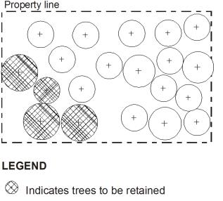
Figure 20.50.350(B)(1): Demonstration of the retention of 20 percent of the significant trees on a site containing no critical areas.
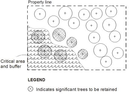
Figure 20.50.350(B)(2): Demonstration of the retention of 30 percent of the significant
trees on a site containing a critical area.
Exception 20.50.350(B):
1. The Director may allow a reduction in the minimum significant tree retention percentage to facilitate preservation of a greater number of smaller trees, a cluster or grove of trees, contiguous perimeter buffers, distinctive skyline features, or based on the City’s concurrence with a written recommendation of an arborist certified by the International Society of Arboriculture or by the American Society of Consulting Arborists as a registered consulting arborist that retention of the minimum percentage of trees is not advisable on an individual site; or
2. In addition, the Director may allow a reduction in the minimum significant tree retention percentage if all of the following criteria are satisfied: The exception is necessary because:
|
• |
There are special circumstances related to the size, shape, topography, location or surroundings of the subject property. |
|
• |
Strict compliance with the provisions of this Code may jeopardize reasonable use of property. |
|
• |
Proposed vegetation removal, replacement, and any mitigation measures are consistent with the purpose and intent of the regulations. |
|
• |
The granting of the exception or standard reduction will not be detrimental to the public welfare or injurious to other property in the vicinity. |
3. If an exception is granted to this standard, the applicant shall still be required to meet the basic tree replacement standards identified in SMC 20.50.360 for all significant trees removed beyond the minimum allowed per parcel without replacement and up to the maximum that would ordinarily be allowed under SMC 20.50.350(B).
4. In addition, the applicant shall be required to plant four trees for each significant tree removed that would otherwise count towards the minimum retention percentage. Trees replaced under this provision shall be at least 12 feet high for conifers and three inches in caliper if otherwise. This provision may be waived by the Director for restoration enhancement projects conducted under an approved vegetation management plan.
5. The Director may not require the retention of a significant tree that must be removed to accommodate the installation of a frontage improvement required as a condition of permit approval pursuant to SMC 20.70.320 when the applicant and the City demonstrate that a reasonable effort has been made to retain the significant tree. If approved for removal, this tree shall not be included in calculation of the minimum retention percentage for the site.
C. Incentives for Higher Levels of Tree Protection. The Director may grant reductions or adjustments to other site development standards if the protection levels identified in subsection B of this section are exceeded. On a case-by-case review, the Director shall determine the balance between tree protection that exceeds the established minimum percentage and variations to site development requirements. If the Director grants adjustments or reductions to site development standards under this provision, then tree protection requirements shall be recorded on the face of the plat, as a notice to title, or on some other legal document that runs with the property. Adjustments that may be considered are:
1. Reductions or variations of the area, width, or composition of required open space and/or landscaping;
2. Variations in parking lot design and/or any access driveway requirements;
3. Variations in building setback requirements;
4. Variations of grading and stormwater requirements.
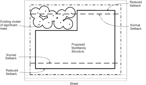
Figure 20.50.350(C): Example of aggregate setback to preserve a cluster of significant trees.
D. Site Design. Site improvements shall be designed and constructed to meet the following:
1. Site improvements shall be designed to give priority to protection of trees with the following characteristics, functions, or location including where the critical root zone of trees on adjoining property is within five feet of the development:
a. Existing stands of healthy trees that have a reasonable chance of survival once the site is developed, are well shaped to withstand the wind and maintain stability over the long term, and will not pose a threat to life or property.
b. Trees which exceed 50 feet in height.
c. Trees and tree clusters which form a continuous canopy.
d. Trees that create a distinctive skyline feature.
e. Trees that have a screening function or provide relief from glare, blight, commercial or industrial harshness.
f. Trees providing habitat value, particularly riparian habitat.
g. Trees within the required yard setbacks or around the perimeter of the proposed development.
h. Trees having a significant land stability function.
i. Trees adjacent to public parks, open space, and critical area buffers.
j. Trees having a significant water-retention function.
3. Building footprints, parking areas, roadways, utility corridors and other structures shall be designed and located with a consideration of tree protection opportunities.
4. The project grading plans shall accommodate existing trees and avoid alteration to grades around existing significant trees to be retained.
5. Required open space and recreational space shall be designed and located to protect existing stands of trees.
6. The site design and landscape plans shall provide suitable locations and adequate area for replacement trees as required in SMC 20.50.360.
7. In considering trees for protection, the applicant shall avoid selecting trees that may become hazardous because of wind gusts, including trees adjacent to utility corridors where falling trees may cause power outages or other damage. Remaining trees may be susceptible to blow downs because of loss of a buffer from other trees, grade changes affecting the tree health and stability and/or the presence of buildings in close proximity.
8. If significant trees have been removed from a closed, forested situation, an adequate buffer of smaller trees shall be retained or planted on the fringe of such significant trees as determined by a certified arborist.
9. All trees located outside of identified building footprints and driveways and at least 10 feet from proposed structures shall be considered as eligible for preservation. However, all significant trees on a site shall be considered when calculating the minimum retention percentage.
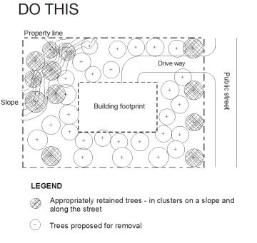
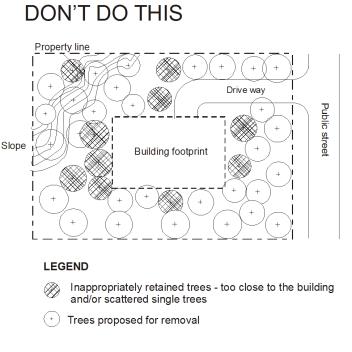
Figure 20.50.350(D): Example of the application of tree retention site design standards. Appropriate retention of a cluster of trees on a slope and frontage trees are shown above. Inappropriate retention of scattered single trees and trees near structures are shown below.
E. Cutting and Pruning of Protected Trees. Trees protected under the provisions of this section shall not be topped. Pruning and maintenance of protected trees shall be consistent with best management practices in the field of arboriculture, such as the American National Standard for Tree Care Operations – Tree, Shrub, and Other Wood Plant Maintenance – Standard Practices (ANSI A300) or similar, and further the long-term health of the tree. Excessive pruning, including topping, stripping, or imbalances, shall not be allowed unless necessary to protect life and property. Protected trees may be pruned to enhance views using methods such as windowing, interlimbing, or skirting up, when completed by a qualified professional arborist and consistent with best management practices.
F. Landmark Trees. Trees which have been designated as landmark trees by the City of Shoreline because they are 30 inches or larger in diameter or particularly impressive or unusual due to species, size, shape, age, historical significance and/or are an outstanding row or group of trees, have become a landmark to the City of Shoreline or are considered specimens of their species shall not be removed unless the applicant meets the exception requirements of subsection B of this section. The Director shall establish criteria and procedures for the designation of landmark trees. (Ord. 984 § 1 (Exh. A), 2023; Ord. 955 § 1 (Exh. A), 2022; Ord. 850 § 1 (Exh. A), 2019; Ord. 789 § 1 (Exh. A), 2018; Ord. 741 § 1 (Exh. A), 2016; Ord. 724 § 1 (Exh. A), 2015; Ord. 640 § 1 (Exh. A), 2012; Ord. 406 § 1, 2006; Ord. 398 § 1, 2006; Ord. 238 Ch. V § 5(G), 2000).
20.50.360 Tree replacement and site restoration.
A. Plans Required. Prior to any tree removal, the applicant shall demonstrate through a clearing and grading plan, tree retention and planting plan, landscape plan, critical area report, mitigation or restoration plans, or other plans acceptable to the Director that tree replacement will meet the minimum standards of this section. Plans shall be prepared by a qualified person or persons at the applicant’s expense. Third-party review of plans, if required, shall be at the applicant’s expense.
B. The City may require the applicant to relocate or replace trees, shrubs, and ground covers, provide erosion control methods, hydroseed exposed slopes, or otherwise protect and restore the site as determined by the Director.
C. Replacement Required. Trees removed under the partial exemption in SMC 20.50.310(B)(1) may be removed per parcel with no replacement of trees required. Any significant tree proposed for removal beyond this limit should be replaced as follows:
1. One existing significant tree of eight inches in diameter at breast height for conifers or 12 inches in diameter at breast height for all others equals one new tree.
2. Each additional three inches in diameter at breast height equals one additional new tree, up to three trees per significant tree removed.
3. Minimum size requirements for replacement trees under this provision: Deciduous trees shall be at least 1.5 inches in caliper and evergreens six feet in height.
Exception 20.50.360(C):
a. No tree replacement is required when the tree is proposed for relocation to another suitable planting site; provided, that relocation complies with the standards of this section.
b. To the extent feasible, all replacement trees shall be replaced on site. When an applicant demonstrates that the project site cannot feasibly accommodate all of the required replacement trees, the Director may allow the payment of a fee in lieu of replacement at the rate set forth in Chapter 3.01 SMC, Fee Schedules, for replacement trees or a combination of reduction in the minimum number of replacement trees required and payment of the fee in lieu of replacement at the rate set forth in Chapter 3.01 SMC, Fee Schedules, if all of the following criteria are satisfied:
i. There are special circumstances related to the size, shape, topography, location or surroundings of the subject property.
ii. Strict compliance with the provisions of this Code may jeopardize reasonable use of property.
iii. Proposed vegetation removal, replacement, and any mitigation measures are consistent with the purpose and intent of the regulations.
iv. The granting of the exception or standard reduction will not be detrimental to the public welfare or injurious to other property in the vicinity.
c. The Director may waive this provision for site restoration or enhancement projects conducted under an approved vegetation management plan.
d. Replacement of significant tree(s) approved for removal pursuant to Exception SMC 20.50.350(B)(5) is not required.
4. Replacement trees required for the Lynnwood Link Extension project shall be native conifer and deciduous trees proportional to the number and type of trees removed for construction, unless as part of the plan required in subsection A of this section the qualified professional demonstrates that a native conifer is not likely to survive in a specific location.
5. Tree replacement where tree removal is necessary on adjoining properties to meet requirements in SMC 20.50.350(D) or as a part of the development shall be at the same ratios in subsections (C)(1), (2), and (3) of this section with a minimum tree size of eight feet in height. Any tree for which replacement is required in connection with the construction of a light rail system/facility, regardless of its location, may be replaced on the project site.
6. Tree replacement related to development of a light rail transit system/facility must comply with this subsection C.
D. The Director may require that a portion of the replacement trees be native species in order to restore or enhance the site to predevelopment character.
E. The condition of replacement trees shall meet or exceed current American Nursery and Landscape Association or equivalent organization’s standards for nursery stock.
F. Replacement of removed trees with appropriate native trees at a ratio consistent with subsection C of this section, or as determined by the Director based on recommendations in a critical area report, will be required in critical areas.
G. The Director may consider smaller-sized replacement plants if the applicant can demonstrate that smaller plants are more suited to the species, site conditions, and to the purposes of this subchapter, and are planted in sufficient quantities to meet the intent of this subchapter.
H. All required replacement trees and relocated trees shown on an approved permit shall be maintained in healthy condition by the property owner throughout the life of the project, unless otherwise approved by the Director in a subsequent permit.
I. Where development activity has occurred that does not comply with the requirements of this subchapter, the requirements of any other section of the Shoreline Development Code, or approved permit conditions, the Director may require the site to be restored to as near pre-project original condition as possible. Such restoration shall be determined by the Director and may include, but shall not be limited to, the following:
1. Filling, stabilizing and landscaping with vegetation similar to that which was removed, cut or filled;
2. Planting and maintenance of trees of a size and number that will reasonably assure survival and that replace functions and values of removed trees; and
3. Reseeding and landscaping with vegetation similar to that which was removed, in areas without significant trees where bare ground exists.
J. Significant trees which would otherwise be retained, but which were unlawfully removed or damaged or destroyed through some fault of the applicant or their representatives shall be replaced in a manner determined by the Director.
K. Nonsignificant trees which are required to be retained as a condition of permit approval, but are unlawfully removed, damaged, or destroyed through some fault of the applicant, representatives of the applicant, or the property owner(s), shall be replaced at a ratio of three to one. Minimum size requirements for replacement trees are deciduous trees at least one and one-half inches in caliper and evergreen trees at least six feet in height.
L. Performance Assurance.
1. The Director may require a performance bond for tree replacement and site restoration permits to ensure the installation of replacement trees, and/or compliance with other landscaping requirements as identified on the approved site plans.
2. A maintenance bond shall be required after the installation of required site improvements and prior to the issuance of a certificate of occupancy or finalization of permit and following required landscape installation or tree replacement. The maintenance bond and associated agreement shall be in place to ensure adequate maintenance and protection of retained trees and site improvements. The maintenance bond shall be for an amount not to exceed the estimated cost of maintenance and protection measures for a minimum of 36 months or as determined by the Director.
3. The Director shall exempt individual single-family lots from a maintenance bond, except where a clearing violation has occurred or tree replacement is located within critical areas or critical area buffers.
M. Monitoring. The Director may require submittal of periodic monitoring reports as necessary to ensure survival of replacement trees. The contents of the monitoring report shall be determined by the Director.
N. Discovery of Undocumented Critical Areas. The Director may stop work authorized by a clearing and grading permit if previously undocumented critical areas are discovered on the site. The Director has the authority to require additional studies, plans and mitigations should previously undocumented critical areas be found on a site. (Ord. 907 § 1 (Exh. C), 2020; Ord. 850 § 1 (Exh. A), 2019; Ord. 741 § 1 (Exh. A), 2016; Ord. 724 § 1 (Exh. A), 2015; Ord. 640 § 1 (Exh. A), 2012; Ord. 406 § 1, 2006; Ord. 398 § 1, 2006; Ord. 299 § 1, 2002; Ord. 238 Ch. V § 5(H), 2000).
20.50.370 Tree protection standards.
The following protection guidelines shall be imposed for all trees to be retained on site or on adjoining property, to the extent off-site trees are subject to the tree protection provisions of this chapter, during the construction process:
A. All required tree protection measures shall be shown on the tree protection and replacement plan, clearing and grading plan, or other plan submitted to meet the requirements of this subchapter. Tree protection shall remain in place for the duration of the permit unless earlier removal is addressed through construction sequencing on approved plans.
B. Critical root zones (tree protection zone) as defined by the International Society of Arboriculture shall be protected. No development, fill, excavation, construction materials, equipment staging, or traffic shall be allowed in the critical root zone of trees that are to be retained.
C. Prior to any land disturbance, temporary construction fences must be placed around the tree protection zone to be preserved. If a cluster of trees is proposed for retention, the barrier shall be placed around the edge formed by the drip lines of the trees to be retained. Tree protection shall remain in place for the duration of the permit unless earlier removal is addressed through construction sequencing on approved plans.
D. Tree protection barriers shall be a minimum of six feet high, constructed of chain link or similar material, subject to approval by the Director. “Tree Protection Area” signs shall be posted visibly on all sides of the fenced areas. On large or multiple-project sites, the Director may also require that signs requesting subcontractor cooperation and compliance with tree protection standards be posted at site entrances.
E. If any construction work needs to be performed inside either the tree drip line, critical root zone, and/or the inner critical root zone, the project arborist will be on site to supervise the work. When excavation must occur within or near the critical root zone, any found roots of three inches or greater in diameter will be cleanly cut to the edge of the trench to avoid ripping of the root.
F. Where tree protection zones are remote from areas of land disturbance, and where approved by the Director, alternative forms of tree protection may be used in lieu of tree protection barriers; provided, that protected trees are completely surrounded with continuous rope or flagging and are accompanied by “Tree Leave Area – Keep Out” signs.
G. Rock walls shall be constructed around the tree, equal to the dripline, when existing grade levels are lowered or raised by the proposed grading.
H. Retain small trees, bushes, and understory plants within the tree protection zone, unless the plant is identified as a regulated noxious weed, a nonregulated noxious weed, or a weed of concern by the King County Noxious Weed Control Board.
I. Preventative Mitigation. In addition to the above minimum tree protection measures, the applicant shall support tree protection efforts by employing, as appropriate, the following preventative measures, consistent with best management practices for maintaining the health of the tree:
1. Pruning of visible deadwood on trees to be protected or relocated;
2. Mulching with a layer of four inches to five inches of wood chips in the critical root zones of retained trees; and
3. Ensuring one inch of irrigation or rainfall per week during and immediately after construction and from early May through September until reliable rainfall occurs in the fall.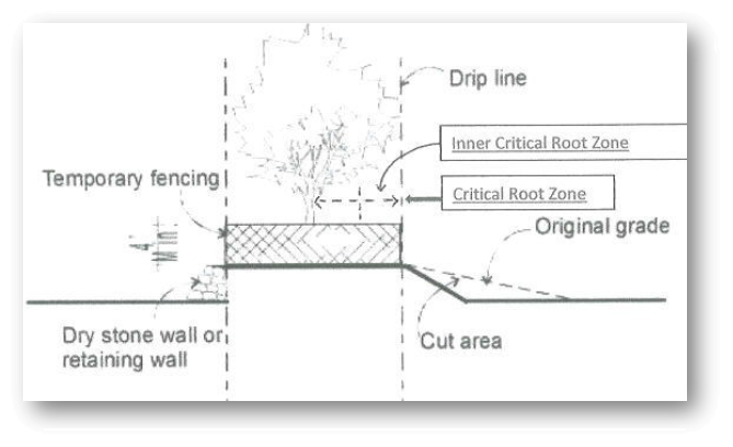
Figure 20.50.370: Illustration of standard techniques used to protect trees during construction.
Exception 20.50.370:
The Director may waive certain protection requirements, allow alternative methods, or require additional protection measures based on concurrence with the recommendation of a certified arborist deemed acceptable to the City. (Ord. 955 § 1 (Exh. A), 2022; Ord. 907 § 1 (Exh. B), 2020; Ord. 741 § 1 (Exh. A), 2016; Ord. 398 § 1, 2006; Ord. 238 Ch. V § 5(I), 2000).
Subchapter 6.
Parking, Access and Circulation
20.50.380 Purpose.
The purpose of this subchapter is to establish standards for parking, access, pedestrian and vehicular circulation, and bicycle facilities as follows:
A. To ensure that the parking and circulation aspects of all developments are well designed with regards to safety, efficiency and convenience of vehicles, bicycles, pedestrians, and transit.
B. To provide convenient and safe access to all buildings and adequate parking for all developments.
C. To reduce demand for parking by encouraging alternative means of transportation, including public transit, rideshare, and bicycles.
D. To promote efficiency through reductions in the number of parking stalls, shared driveway access and shared parking facilities.
E. To assure safe, convenient, efficient and adequately sized parking facilities.
F. To increase pedestrian mobility and provide safe, pleasant and direct pedestrian access. (Ord. 238 Ch. V § 6(A), 2000).
20.50.385 Thresholds – Required site improvements.
Repealed by Ord. 654. (Ord. 581 § 1 (Exh. 1), 2010; Ord. 515 § 1, 2008; Ord. 299 § 1, 2002).
20.50.390 Minimum off-street parking requirements – Standards.
A. Off-street parking areas shall contain at a minimum the number of parking spaces stipulated in Tables 20.50.390A through 20.50.390D.
|
RESIDENTIAL USE |
MINIMUM SPACES REQUIRED |
|---|---|
|
Single-family detached: |
2.0 per dwelling unit. |
|
Single-family attached: |
2.0 per dwelling unit. 1.0 per dwelling unit in the MUR zones. |
|
Multifamily dwelling: |
|
|
Studio units: |
0.75 per dwelling unit |
|
One-bedroom units: |
0.75 per dwelling unit |
|
Two-bedroom plus units: |
1.5 per dwelling unit |
|
Accessory dwelling units: |
1.0 per dwelling unit |
|
Mobile home park: |
2.0 per dwelling unit |
|
Cottage housing development: |
1.0 per unit |
|
RESIDENTIAL USE |
MINIMUM SPACES REQUIRED |
|---|---|
|
Bed and breakfast guesthouse: |
1 per guest room, plus 2 per facility |
|
Residential care facilities: |
1 per 3 patients, plus 1 per FTE employee on duty |
|
Dormitory, including religious: |
1 per 2 units |
|
Hotel/motel, including organizational hotel/lodging: |
1 per unit |
|
Assisted living facilities: |
1 per 3 dwelling or sleeping units |
Note: Square footage in this subchapter refers to net usable area and excludes walls, corridors, lobbies, bathrooms, etc.
|
NONRESIDENTIAL USE |
MINIMUM SPACES REQUIRED |
|---|---|
|
General services uses: |
1 per 300 square feet |
|
Professional office uses: |
1 per 500 square feet |
|
Manufacturing uses: |
0.9 per 1,000 square feet |
|
Recreation/culture uses: |
1 per 300 square feet |
|
Regional uses: |
(Director) |
|
Retail trade uses: |
1 per 400 square feet |
Note: Square footage in this subchapter refers to net usable area and excludes walls, corridors, lobbies, bathrooms, etc.
|
NONRESIDENTIAL USE |
MINIMUM SPACES REQUIRED |
|---|---|
|
Bowling center: |
2 per lane |
|
Houses of worship |
1 per 5 fixed seats, plus 1 per 50 square feet of gross floor area without fixed seats used for assembly purposes |
|
Conference center: |
1 per 3 fixed seats, plus 1 per 50 square feet used for assembly purposes without fixed seats, or 1 per bedroom, whichever results in the greater number of spaces |
|
Construction and trade: |
1 per 300 square feet of office, plus 1 per 3,000 square feet of storage area |
|
Courts: |
3 per courtroom, plus 1 per 50 square feet of fixed-seat or assembly area |
|
Daycare I: |
2 per facility, above those required for the baseline of the underlying zone |
|
Daycare II: |
2 per facility, plus 1 for each 20 clients |
|
Elementary schools: |
1.2 per staff member |
|
Fire facility: |
(Director) |
|
Food stores less than 15,000 square feet: |
1 per 350 square feet |
|
Funeral home/crematory: |
1 per 50 square feet of chapel area |
|
Fuel service stations with grocery, no service bays: |
1 per facility, plus 1 per 300 square feet of store |
|
Fuel service stations without grocery: |
3 per facility, plus 1 per service bay |
|
Golf course: |
3 per hole, plus 1 per 300 square feet of clubhouse facilities |
|
Golf driving range: |
1 per tee |
|
Heavy equipment repair: |
1 per 300 square feet of office, plus 0.9 per 1,000 square feet of indoor repair area |
|
High schools with stadium: |
1 per staff member plus 1 per 10 students, and 1 per 3 fixed seats in stadium |
|
High schools without stadium: |
1 per staff member, plus 1 per 10 students |
|
Home occupation: |
In addition to required parking for the dwelling unit, 1 for any nonresident employed by the home occupation and 1 for patrons when services are rendered on site |
|
Hospital: |
1 per bed |
|
Middle/junior high schools: |
1.2 per staff member |
|
Nursing facilities: |
1 per 4 beds |
|
Outdoor advertising services: |
1 per 300 square feet of office, plus 0.9 per 1,000 square feet of storage area |
|
Outpatient and veterinary clinic offices: |
1 per 300 square feet of office, labs, and examination rooms |
|
Park/playfield: |
(Director) |
|
Police facility: |
(Director) |
|
Public agency archives: |
0.9 per 1,000 square feet of storage area, plus 1 per 50 square feet of waiting/reviewing area |
|
Public agency yard: |
1 per 300 square feet of offices, plus 0.9 per 1,000 square feet of indoor storage or repair area |
|
Restaurants: |
1 per 75 square feet in dining or lounge area |
|
Self-storage facilities: |
1 per 0.000130 square feet of storage area, plus 2 for any resident director’s unit |
|
Specialized instruction schools: |
1 per classroom, plus 1 per 2 students |
|
Theater: |
1 per 3 fixed seats |
|
Vocational schools: |
1 per staff member, plus 1 per 2 students |
|
Warehousing and storage: |
1 per 300 square feet of office, plus 0.5 per 1,000 square feet of storage area |
|
Wholesale trade uses: |
0.9 per 1,000 square feet |
|
Winery/brewery: |
0.9 per 1,000 square feet, plus 1 per 50 square feet of tasting area |
|
RESIDENTIAL USE |
MINIMUM EV SPACES REQUIRED |
|---|---|
|
Single-family detached/single-family attached/cottage housing development: |
An EV-ready space for each private garage or private parking area provided for a dwelling unit |
|
Multifamily dwelling/cottage housing development: |
A minimum of 20 percent of EV-ready spaces in shared parking garages or shared parking spaces |
|
Nonresidential: |
A minimum of 10 percent EV-ready spaces of the required parking spaces |
1. An EV-ready space is a space that provides a complete electric circuit with 208/240 volt, 40-ampere capacity charging receptacle outlet or termination point, including electrical service capacity.
2. For multifamily and nonresidential uses, one accessible parking space shall be an EV-ready space.
3. If the formula for determining the number of EV-ready spaces results in a fraction, the number of required spaces shall be rounded to the nearest whole number, with fractions of 0.50 or greater rounding up and fractions below 0.50 rounding down.
Exception 20.50.390(A)(1): If the formula for determining the number of off-street parking spaces results in a fraction, the number of off-street parking spaces shall be rounded to the nearest whole number, with fractions of 0.50 or greater rounding up and fractions below 0.50 rounding down.
Exception 20.50.390(A)(2): When the City of Shoreline has received a shell building permit application, off-street parking requirements shall be based on the possible tenant improvements or uses authorized by the zone designation and compatible with the limitations of the shell permit. When the range of possible uses results in different parking requirements, the Director will establish the amount of parking based on a likely range of uses.
Exception 20.50.390(A)(3): Where other provisions of this Code stipulate higher maximum parking or reduced minimum parking requirements, those provisions shall apply.
Exception 20.50.390(A)(4): Minimum parking requirements may be reduced through provisions in SMC 20.50.400.
B. Off-street parking ratios expressed as number of spaces per square feet shall be based on the usable or net square footage of floor area, exclusive of nonpublic areas. Nonpublic areas include, but are not limited to, building maintenance areas, storage areas, closets, or restrooms.
C. For all nonresidential uses, the maximum amount of allowed parking shall not exceed 50 percent over the minimum required number of stalls. Any proposal for parking that exceeds 10 percent over the minimum required number of stalls must be approved by the Director.
D. Any amount of surface parking lot that is over the minimum required number of stalls shall be paved with permeable pavement.
E. If this chapter does not specify a parking requirement for a land use, the Director shall establish the minimum requirement based on a study of anticipated parking demand. Transportation demand management actions taken at the site shall be considered in determining anticipated parking demand. The study shall provide sufficient information to demonstrate the parking demand for a specific land use will be satisfied. The study shall be prepared by a professional engineer with expertise in traffic and parking analyses, or a qualified professional as authorized by the Director. (Ord. 984 § 1 (Exh. A), 2023; Ord. 930 § 1 (Exh. A-1), 2021; Ord. 907 § 1 (Exhs. A – C), 2020; Ord. 850 § 1 (Exh. A), 2019; Ord. 824 § 1 (Exh. A), 2018; Ord. 767 § 1 (Exh. A), 2017; Ord. 731 § 1 (Exh. A), 2015; Ord. 706 § 1 (Exh. A), 2015; Ord. 669 § 1 (Exh. A), 2013; Ord. 663 § 1 (Exh. 1), 2013; Ord. 654 § 1 (Exh. 1), 2013; Ord. 581 § 1 (Exh. 1), 2010; Ord. 238 Ch. V § 6(B-1), 2000).
20.50.400 Reductions to minimum parking requirements.
A. Reductions of up to 25 percent may be approved by the Director when subsection (A)(1) of this section is met, or when a combination of two or more of the following subsections (A)(2) through (9) of this section is met:
1. A high-capacity transit service stop (e.g., bus rapid transit, light rail) is within one-quarter mile of the development’s property line. This provision applies to developments seeking reductions prior to and after commencement of revenue service at new stops.
2. A parking demand analysis prepared by a qualified professional demonstrates that parking demand can be satisfied with a reduced parking requirement.
3. There is a shared parking agreement with nearby parcels within reasonable proximity where land uses do not have conflicting parking demands. A record on title with King County is required.
4. A parking management plan is prepared by the applicant according to criteria established by the Director.
5. A City-approved residential parking zone (RPZ) is established for the surrounding neighborhood within a one-quarter-mile radius of the development’s property line. The management cost for the RPZ must be paid by the applicant and/or property owner on an annual basis.
6. A public access easement that is a minimum of eight feet wide, safely lit, and connects through a parcel between at least two different rights-of-way. The access easement shall be developed with a sidewalk or shared use path that complies with the Engineering Design Manual. This easement may include other pedestrian facilities such as plazas and bike facilities.
7. Retention of at least 20 percent of the significant trees on a site zoned MUR-70'.
8. Replacement of all significant trees removed on a site zoned MUR-70' as follows:
a. One existing significant tree of eight inches in diameter at breast height for conifers or 12 inches in diameter at breast height for all others equals one new tree.
b. Each additional three inches in diameter at breast height equals one additional new tree, up to three trees per significant tree removed.
c. Minimum Size Requirements for Replacement Trees Under This Subsection. Deciduous trees shall be at least one and one-half inches in caliper and evergreens at least six feet in height.
9. On-site dedicated parking spaces for a car-sharing service with an agreement with the provider(s).
B. Parking reductions for Deep Green Incentive Program projects are set forth in SMC 20.50.630. Reductions granted under the Deep Green Incentive Program shall not be combined with the parking reductions in subsections A and C of this section.
C. Parking reductions of up to 50 percent may be approved for new residential, mixed-use, and commercial development in the MUR-70' zone provided the following criteria are satisfied:
1. A Transportation Demand Management Plan is prepared by a qualified professional and shall:
a. Assess actual parking demand based on proposed land uses and the existing and future neighborhood land use context;
b. Identify project-specific strategies, which may include strategies on a list established and maintained by the Director, that will be implemented to reduce the development’s parking demand; and
c. Establish clear performance objectives and a mechanism for ongoing monitoring and adjustment of the TDM strategies to adapt to changing conditions throughout the life of the development.
2. Upon request by the City, the owner shall provide parking utilization data for the development and an assessment of the TDM Plan’s performance and whether it is meeting objectives. If deficiencies in meeting objectives are found, the owner shall revise the Plan and it shall be reviewed pursuant to subsection (C)(1) of this section.
D. A request for a parking reduction shall be processed as a Type A action, as set forth in SMC 20.30, Subchapter 2.
E. When granting a parking reduction, the Director may impose performance standards and conditions of approval on a project, including a financial guarantee.
F. Reductions of up to 50 percent may be approved by the Director for the portion of housing providing low-income housing units that are 60 percent of AMI or less as defined by the U.S. Department of Housing and Urban Development. This parking reduction may be combined with parking reductions identified in subsection A of this section. (Ord. 968 § 1 (Exh. A), 2022; Ord. 930 § 1 (Exh. A-1), 2021; Ord. 907 § 1 (Exh. B), 2020; Ord. 839 § 1 (Exh. A), 2019; Ord. 833 § 1 (Exh. A), 2018; Ord. 760 § 1 (Exh. A), 2017; Ord. 731 § 1 (Exh. A), 2015; Ord. 706 § 1 (Exh. A), 2015; Ord. 669 § 1 (Exh. A), 2013; Ord. 654 § 1 (Exh. 1), 2013; Ord. 238 Ch. V § 6(B-2), 2000).
20.50.410 Parking design standards.
A. All vehicle parking and storage for single-family detached dwellings, cottage housing developments, and duplexes must be in a garage, carport or on an approved impervious surface or pervious concrete or pavers. Any surface used for vehicle parking or storage must have direct and unobstructed driveway access.
B. All vehicle parking and storage for multifamily and commercial uses must be on a paved surface, pervious concrete, or pavers. All vehicle parking shall be located on the same parcel or same development area that parking is required to serve.
C. Repealed by Ord. 959.
D. On property occupied by a single-family detached residence or duplex, the total number of vehicles wholly or partially parked or stored outside of a building or carport shall not exceed six, excluding a maximum combination of any two boats, recreational vehicles, or trailers. This section shall not be interpreted to allow the storage of junk vehicles as covered in SMC 20.30.750.
E. Off-street parking areas shall not be located more than 500 feet from the building they are required to serve. Where the off-street parking areas do not abut the buildings they serve, the required maximum distance shall be measured from the nearest building entrance that the parking area serves:
1. For all single detached dwellings, the parking spaces shall be located on the same lot they are required to serve;
2. For all other residential dwellings, at least a portion of parking areas shall be located within 100 feet from the building(s) they are required to serve; and
3. For all nonresidential uses permitted in residential zones, the parking spaces shall be located on the same lot they are required to serve and at least a portion of parking areas shall be located within 150 feet from the nearest building entrance they are required to serve.
Exception 20.50.410(E)(1): In commercial zones, the Director may allow required parking to be supplied in a shared parking facility that is located more than 500 feet from the building it is designed to serve if adequate pedestrian access is provided and the applicant submits evidence of a long-term, shared parking agreement.
F. The minimum parking space and aisle dimensions for the most common parking angles are shown in Table 20.50.410F below. For parking angles other than those shown in the table, the minimum parking space and aisle dimensions shall be determined by the Director. For these Director’s determinations for parking angles not shown in Table 20.50.410F, parking plans for angle parking shall use space widths no less than eight feet, six inches for a standard parking space design and eight feet for a compact car parking space design. Structural columns or permanent structures can only encroach into a parking stall six inches the first four feet and the last four feet of the parking stall.
Table 20.50.410F – Minimum Parking Stall and Aisle Dimensions
|
A |
B |
C |
D |
E |
F |
||
|---|---|---|---|---|---|---|---|
|
Parking Angle |
Stall Width (feet) |
Curb Length (feet) |
Stall Depth (feet) |
Aisle Width (feet) |
Unit Depth (feet) |
||
|
1-Way |
2-Way |
1-Way |
2-Way |
||||
|
0 |
8.0* Min. 8.5 Desired 9.0 |
20.0* 22.5 22.5 |
8.0 8.5 9.0 |
12.0 12.0 12.0 |
20.0 20.0 20.0 |
** 29.0 30.0 |
** 37.0 38.0 |
|
30 |
8.0* Min. 8.5 Desired 9.0 |
16.0* 17.0 18.0 |
15.0 16.5 17.0 |
10.0 10.0 10.0 |
20.0 20.0 20.0 |
** 42.0 44.0 |
** 53.0 54.0 |
|
45 |
8.0* Min. 8.5 Desired 9.0 |
11.5* 12.0 12.5 |
17.0* |
12.0 12.0 12.0 |
20.0 20.0 20.0 |
** 50.0 51.0 |
** 58.0 59.0 |
|
60 |
8.0* Min. 8.5 Desired 9.0 |
9.6* 10.0 10.5 |
18.0 20.0 21.0 |
18.0 18.0 18.0 |
20.0 20.0 20.0 |
** 58.0 60.0 |
** 60.0 62.0 |
|
90 |
8.0* Min. 8.5 Desired 9.0 |
8.0* 8.5 9.0 |
16.0* 20.0 20.0 |
23.0 23.0 23.0 |
23.0 23.0 23.0 |
** 63.0 63.0 |
** 63.0 63.0 |
Notes:
* For compact stalls only. No more than 50 percent of the required minimum number of parking stalls may be compact spaces.
** Variable, with compact and standard combinations.
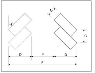
Figure 20.50.410(F)(1): Diagram of corresponding parking dimensions A through F from Table 20.50.410F
Exception 20.50.410(F)(1): The parking space depth may be reduced up to 18 inches when vehicles overhang a walkway under the following conditions:
1. Wheel stops or curbs are installed that provide a maximum 18-inch overhang; and
2. The remaining walkway provides a minimum of 60 inches of unimpeded passageway for pedestrians.
Exception 20.50.410(F)(2): Tandem or end-to-end parking is allowed in residential developments. Single-family, duplex and townhouse developments may have tandem parking areas for each dwelling unit but shall not combine parking for separate dwelling units in tandem parking areas.
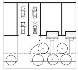
Figure Exception to 20.50.410(F)(2): Illustration of tandem parking.
Exception 20.50.410(F)(3): Vanpool/carpool parking areas shall meet the following minimum design standards;
1. A minimum vertical clearance of seven feet, three inches shall be provided to accommodate van vehicles if designated vanpool/carpool parking spaces are located in a parking structure; and
2. A minimum turning radius of 26 feet, four inches with a minimum turning diameter (curb to curb) of 52 feet, five inches shall be provided from parking aisles to adjacent carpool/vanpool parking spaces.
G. Asphalt or concrete surfaced parking areas shall have parking spaces marked by surface paint lines or suitable substitute traffic marking material in accordance with Washington State Department of Transportation standards. Wheel stops are required where a parked vehicle encroaches on adjacent property, pedestrian access or circulation areas, right-of-way or landscaped areas. Typical approved markings and wheel stop locations are illustrated in Figure 20.50.410(G).
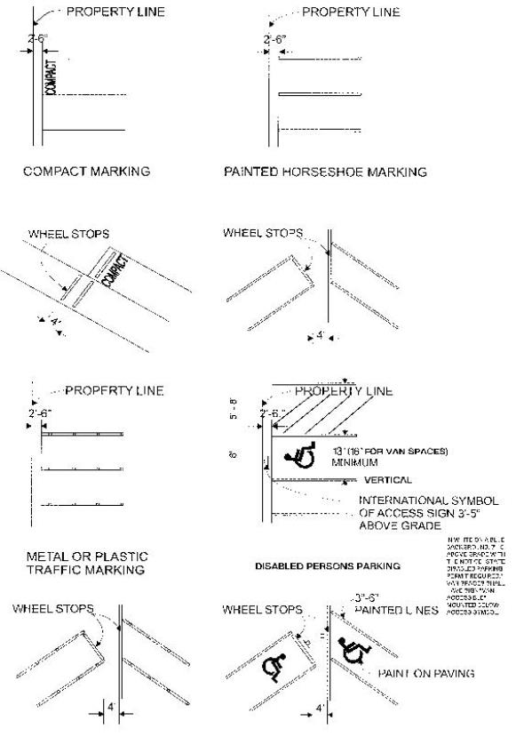
Figure 20.50.410(G): Pavement marking and wheel stop standards.
Note that parking spaces must meet setbacks from property lines where required by the zone.
H. Any parking spaces abutting a landscaped area on the driver or passenger side of the vehicle shall provide an additional 18 inches above the minimum space width requirement to provide a place to step other than in the landscaped area. In a parking garage, any space abutting a wall shall provide an additional 18 inches. The additional width shall be separated from the adjacent parking space by a parking space division stripe. This requirement does not apply to single-family and duplex developments.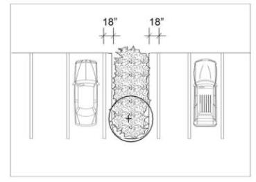
Figure 20.50.410(H): Illustration of buffer between parking and landscaping.
I. Parking spaces shall be located outside of any required setbacks, provided driveways located in setbacks may be used for parking.
Exception 20.50.410(I)(1): If parking is located below grade, parking may be located within the required setback; provided, that the portion of the parking structure located within setback is landscaped or serves as pedestrian access.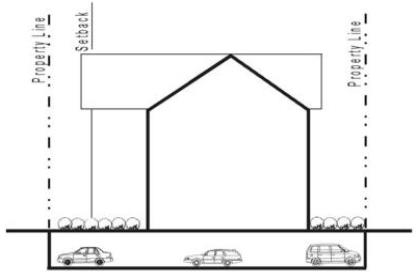
Figure Exception to 20.50.410(I)(1): Illustration of underground parking.
J. Any parking stalls located in enclosed buildings must be totally within the enclosed building.
K. Off-street parking and access for physically disabled persons shall be provided in accordance with the current version of ICC A117.1, Section 1106, Table 1106.1, Chapter 502.
L. Every nonresidential building engaged in retail, wholesale, manufacturing or storage activities, excluding self-service storage facilities, shall provide loading spaces in accordance with the standards listed below in Table 20.50.410L.
Table 20.50.410L
|
GROSS FLOOR AREA |
REQUIRED NUMBER OF LOADING SPACES |
|---|---|
|
10,000 to 16,000 square feet |
1 |
|
16,001 to 40,000 square feet |
2 |
|
40,001 to 64,000 square feet |
3 |
|
64,001 to 96,000 square feet |
4 |
|
96,001 to 128,000 square feet |
5 |
|
128,001 to 160,000 square feet |
6 |
|
160,001 to 196,000 square feet |
7 |
|
For each additional 36,000 square feet |
1 additional |
M. Every building engaged in retail, hotel, office building, restaurant, hospital, auditorium, convention hall, exhibition hall, sports arena/stadium, or other similar use shall provide loading spaces in accordance with the standards listed in Table 20.50.410M.
Table 20.50.410M
|
GROSS FLOOR AREA |
REQUIRED NUMBER OF LOADING SPACES |
|---|---|
|
40,000 to 60,000 square feet |
1 |
|
60,001 to 160,000 square feet |
2 |
|
160,001 to 264,000 square feet |
3 |
|
264,001 to 388,000 square feet |
4 |
|
388,001 to 520,000 square feet |
5 |
|
520,001 to 652,000 square feet |
6 |
|
652,001 to 784,000 square feet |
7 |
|
784,001 to 920,000 square feet |
8 |
|
For each additional 140,000 square feet |
1 additional |
N. Each loading space required by this section shall be a minimum of 10 feet wide, 30 feet long, and have an unobstructed vertical clearance of 14 feet six inches, and shall be surfaced, improved and maintained as required by the Engineering Development Guide. Loading spaces shall be located so that trucks shall not obstruct pedestrian or vehicle traffic movement or project into any public right-of-way. All loading space areas shall be separated from required parking areas and shall be designated as truck loading spaces.
O. Any loading space located within 100 feet of areas zoned for residential use shall be screened and operated as necessary to reduce noise and visual impacts. Noise mitigation measures may include architectural or structural barriers, berms, walls, or restrictions on the hours of operation.
P. Multi-story self-service storage facilities shall provide two loading spaces, single-story facilities one loading space, adjacent to each building entrance that provides common access to interior storage units. Each loading berth shall measure not less than 25 feet by 12 feet with an unobstructed vertical clearance of 14 feet six inches, and shall be surfaced, improved and maintained as required by the Engineering Development Guide.
Q. Any floor area additions or structural alterations to a building shall be required to provide loading space or spaces as set forth in this section.
R. All parking lot lighting shall be nonglare and shielded to minimize direct illumination of abutting properties and adjacent streets.
S. Electric Vehicle Signage.
1. Electric vehicle charging stations available for public use shall have posted signage, as identified in this subsection, allowing only charging electric vehicles to park in such spaces. For purposes of this subsection, “charging” means that an electric vehicle is parked at an electric vehicle charging station and is connected to the charging station equipment.
2. Signage for parking of electric vehicles shall include:
a. Information about the charging station to identify voltage and amperage levels and any time of use, fees, or safety information.
b. As appropriate, directional signs at appropriate decision points to effectively guide motorists to the charging station space(s).
3. EV signage is exempt from a sign permit. (Ord. 984 § 1 (Exh. A), 2023; Ord. 959 § 1 (Exh. A), 2022; Ord. 930 § 1 (Exh. A-1), 2021; Ord. 907 § 1 (Exh. B), 2020; Ord. 850 § 1 (Exh. A), 2019; Ord. 789 § 1 (Exh. A), 2018; Ord. 731 § 1 (Exh. A), 2015; Ord. 706 § 1 (Exh. A), 2015; Ord. 669 § 1 (Exh. A), 2013; Ord. 663 § 1 (Exh. 1), 2013; Ord. 654 § 1 (Exh. 1), 2013; Ord. 560 § 4 (Exh. A), 2009; Ord. 469 § 1, 2007; Ord. 391 § 4, 2005; Ord. 352 § 1, 2004; Ord. 299 § 1, 2002; Ord. 238 Ch. V § 6(B-3), 2000).
20.50.420 Vehicle access and circulation – Standards.
A. Driveways providing ingress and egress between off-street parking areas and abutting streets shall be designed, located, and constructed in accordance with the adopted Engineering Development Manual.
B. Driveways for nonresidential development may cross required setbacks or landscaped areas in order to provide access between the off-street parking areas and the street, provided no more than 10 percent of the required landscaping is displaced by the driveway.
C. Direct access from the street right-of-way to off-street parking areas shall be subject to the requirements of Chapter 20.60 SMC, Adequacy of Public Facilities.
D. No dead-end alley may provide access to more than eight required off-street parking spaces.
E. Businesses with drive-through windows shall provide stacking space to prevent any vehicles from extending onto the public right-of-way, or interfering with any pedestrian circulation, traffic maneuvering, or other parking space areas. Stacking spaces for drive-through or drive-in uses may not be counted as required parking spaces.
F. A stacking space shall be an area measuring eight feet by 20 feet with direct forward access to a service window of a drive-through facility.
G. Uses providing drive-up or drive-through services shall provide vehicle stacking spaces as follows:
1. For each drive-up window of a bank/financial institution, business service, or other drive-through use not listed, a minimum of five stacking spaces shall be provided.
2. For each service window of a drive-through restaurant, a minimum of seven stacking spaces shall be provided.
H. Alleys shall be used for loading and vehicle access to parking wherever practicable. (Ord. 631 § 1 (Exh. 1), 2012; Ord. 469 § 1, 2007; Ord. 299 § 1, 2002; Ord. 238 Ch. V § 6(B-4), 2000).
20.50.430 Nonmotorized access and circulation – Pedestrian access and circulation – Standards.
Repealed by Ord. 731. (Ord. 581 § 1 (Exh. 1), 2010; Ord. 238 Ch. V § 6(C-1), 2000).
20.50.440 Bicycle facilities – Standards.
A. Short-Term Bicycle Parking. Short-term bicycle parking shall be provided as specified in Table A. Short-term bicycle parking is for bicycles anticipated to be at a building site for less than four hours.
|
Type of Use |
Minimum Number of Spaces Required |
|---|---|
|
Multifamily |
1 per 10 dwelling units |
|
Commercial and all other nonresidential uses |
1 bicycle stall per 12 vehicle parking spaces (minimum of 1 space) |
Installation of Short-Term Bicycle Parking. Short-term bicycle parking shall comply with all of the following:
1. It shall be visible from a building’s entrance;
Exception: Where directional signage is provided at a building entrance, short-term bicycle parking shall be permitted to be provided at locations not visible from the main entrance.
2. It shall be located at the same grade as the sidewalk or at a location reachable by ramp or accessible route;
3. It shall be provided with illumination of not less than one footcandle at the parking surface;
4. It shall have an area of not less than 18 inches by 60 inches for each bicycle;
5. It shall be provided with a rack or other facility for locking or securing each bicycle;
6. The rack or other locking feature shall be permanently attached to concrete or other comparable material; and
7. The rack or other locking feature shall be designed to accommodate the use of U-locks for bicycle security.
B. Long-Term Bicycle Parking. Long-term bicycle parking shall be provided as specified in Table B. Long-term bicycle parking is for bicycles anticipated to be at a building site for four or more hours.
|
Type of Use |
Minimum Number of Spaces Required |
|---|---|
|
Multifamily |
0.5 per unit except for units where individual garages are provided. |
|
Commercial and all other nonresidential uses |
1 per 25,000 square feet of floor area; not less than 2 spaces |
Installation of Long-Term Bicycle Parking. Long-term bicycle parking shall comply with all of the following:
1. It shall be located on the same site as the building;
2. It shall be located inside the building, or shall be located within 300 feet of the building’s main entrance and provided with permanent cover including, but not limited to, roof overhang, awning, or bicycle storage lockers;
3. Illumination of not less than one footcandle at the parking surface shall be available;
4. It shall have an area of not less than 18 inches by 60 inches for each bicycle;
5. It shall be provided with a permanent rack or other facility for locking or securing each bicycle. Up to 25 percent of the racks may be located on walls in garages.
6. Vehicle parking spaces that are in excess of those required by code may be used for the installation of long-term bicycle parking spaces.
Exception 20.50.440(1): The Director may authorize a reduction in long-term bicycle parking where the housing is specifically assisted living or serves special needs or disabled residents.
Exception 20.50.440(2): Ground floor units with direct access to the outside may be exempted from the long-term bicycle parking calculation.
Exception 20.50.440(3): The Director may require additional spaces when it is determined that the use or its location will generate a high volume of bicycle activity. Such a determination will include, but not be limited to:
1. Park/playfield;
2. Marina;
3. Library/museum/arboretum;
4. Elementary/secondary school;
5. Sports club; or
6. Retail business and office (when located along a developed bicycle trail or designated bicycle route).
7. Campus zoned properties and transit facilities. (Ord. 695 § 1 (Exh. A), 2014; Ord. 663 § 1 (Exh. 1), 2013; Ord. 555 § 1 (Exh. 1), 2009; Ord. 238 Ch. V § 6(C-2), 2000).
Subchapter 7.
Landscaping
20.50.450 Purpose.
The purposes of this subchapter are:
A. To enhance the visual continuity within and between neighborhoods.
B. To establish at least an urban tree canopy through landscaping and street trees.
C. To screen areas of low visual interests and buffer potentially incompatible developments.
D. To complement the site and building design with landscaping. (Ord. 907 § 1 (Exh. A), 2020; Ord. 238 Ch. V § 7(A), 2000).
20.50.455 Thresholds – Required site improvements.
Repealed by Ord. 654. (Ord. 581 § 1 (Exh. 1), 2010; Ord. 515 § 1, 2008; Ord. 299 § 1, 2002).
20.50.457 Administrative design review.
Administrative design review approval under SMC 20.30.297 is required for all development applications that propose departures from the landscape standards in this subchapter. (Ord. 930 § 1 (Exh. A-1), 2021).
20.50.460 Landscaping – Types of landscaping screens – Standards.
A. Type I landscaping is a “full screen” that functions as a visual barrier. Type I landscaping shall minimally consist of:
1. A mix of primarily evergreen trees and shrubs generally interspersed throughout the landscaped strip and spaced to form a continuous screen.
2. Eighty percent of trees and shrubs shall be evergreen.
3. Trees planted at 10 feet in height, at the rate of one tree per 10 linear feet of landscaped strip and spaced no more than 15 feet apart.
4. Shrubs planted from five-gallon containers or at 30 inches in height and spaced no more than three feet apart on center.
5. Ground covers planted from minimally four-inch pots and spaced no more than 18 inches apart.
B. Type II landscaping is a “filtered screen” that functions as a partial visual separator to soften the appearance of parking areas and building elevations. Type II landscaping shall minimally consist of:
1. Trees generally interspersed throughout the landscaped strip and spaced to create a continuous canopy.
2. Provide a mix of deciduous and evergreen trees and shrubs.
3. Trees planted at 1.5-inch caliper, at the rate of one per 25 linear feet of landscaped strip and spaced no more than 30 feet apart on center.
4. Shrubs planted from five-gallon containers or at 24 inches in height and spaced no more than four feet apart on center.
5. Ground covers planted from minimally four-inch pots and spaced no more than 18 inches apart.
C. Existing, healthy trees and shrubs, vegetated critical areas, landscaped bio-swales, or trees and their area within the dripline may substitute for required landscaping tree-for-tree and area-for-area. In order to promote the retention of existing mature trees during site development, credit shall be given for one additional required tree if the retained tree is significant (eight-inch diameter at breast height for conifer and 12-inch diameter at breast height if deciduous). (See Subchapter 5 of this chapter, Tree Conservation, Land Clearing, and Site Grading Standards, and Chapter 20.80 SMC, Critical Areas, for additional requirements).
D. Detached single-family development shall be exempt from all landscape requirements with the exception of required street trees along arterials. (Ord. 238 Ch. V § 7(B-1), 2000).
20.50.470 Street frontage landscaping for parking lots.
A. Provide a five-foot-wide, Type II landscaping that incorporates a continuous masonry wall between three and four feet in height. The landscape shall be located between the public sidewalk or residential units and the wall; or
B. Provide at least 10-foot-wide, Type II landscaping.
C. All parking lots shall be separated from ground-level, residential development by the required setback and planted with Type I landscaping.
|
|
|
|
20.50.470(A) Parking lot planting buffer with low wall |
20.50.470(B) 10-foot parking lot buffer with Type II landscaping |
D. Vehicle Display Areas Landscaping. Shall be determined by the Director through administrative design review under SMC 20.30.297. Subject to the Director’s discretion to reduce or vary the depth, landscaped areas shall be at least 10 feet deep relative to the front property line. Vehicle display areas shall be framed by appropriate landscape materials along the front property line. While allowing the vehicles on display to remain plainly visible from the public rights-of-way, these materials shall be configured to create a clear visual break between the hardscape in the public rights-of-way and the hardscape of the vehicle display area. Appropriate landscape construction materials shall include any combination of low (three feet or less in height) walls or earthen berms with ground cover, shrubs, trees, trellises, or arbors. (Ord. 789 § 1 (Exh. A), 2018; Ord. 654 § 1 (Exh. 1), 2013; Ord. 581 § 1 (Exh. 1), 2010; Ord. 560 § 4 (Exh. A), 2009; Ord. 238 Ch. V § 7(B-2), 2000).
20.50.480 Street trees and landscaping within the right-of-way – Standards.
A. When frontage improvements are required by Chapter 20.70 SMC, street trees are required for all commercial, office, public facilities, industrial, multifamily developments, and for single-family subdivisions, and cottage housing developments on all arterial streets.
B. Frontage landscaping may be placed within City street rights-of-way subject to review and approval by the Director. Adequate space should be maintained along the street line to replant the required landscaping should subsequent street improvements require the removal of landscaping within the rights-of-way.
C. Street trees and landscaping must meet the standards for the specific street classification abutting the property as depicted in the Engineering Development Guide including but not limited to size, spacing, and site distance. All street trees must be selected from the City-approved street tree list. (Ord. 984 § 1 (Exh. A), 2023; Ord. 739 § 1 (Exh. A), 2016; Ord. 731 § 1 (Exh. A), 2015; Ord. 581 § 1 (Exh. 1), 2010; Ord. 406 § 1, 2006; Ord. 238 Ch. V § 7(B-3), 2000).
20.50.485 Front facade landscaping, single-family attached and mixed single-family attached developments – Standards.
A. The portion of the building adjacent to public rights-of-way shall have landscaping along the building facade. Foundation landscaping shall abut the building (while allowing the necessary space for growth) and shall be used or installed in such a manner so as to screen mechanical equipment attached to or adjacent to the building, provide direction to and enhance entrances and pedestrian pathways, and provide visual breaks along building facades.
B. 1. Landscaping shall be provided at a depth of at least 50 percent of the required front yard setback. The depth of required landscaping for properties with frontage on 145th Street or 185th Street shall be calculated by subtracting the amount of right-of-way dedication easement.
2. If a property has a required setback of zero feet, landscaping shall be provided at a depth of at least four feet and width at least 30 percent of the unit width. The required landscaping shall abut the entry. For example, if the unit width is 20 feet, the landscaping next to the entry shall be a minimum of six feet wide.
C. Foundation plantings may be comprised of trees, shrubs, accent plants, ornamental grasses, and ground cover in any combination; provided, that no more than 50 percent of the total required landscaping area consists of ground cover.
D. At least one three-gallon shrub for every three lineal feet of foundation shall be provided.
E. Shrubs shall be a mix of deciduous and evergreens.
F. When calculating the minimum number of required plants, the linear distance of openings for doors entering the building shall be excluded.
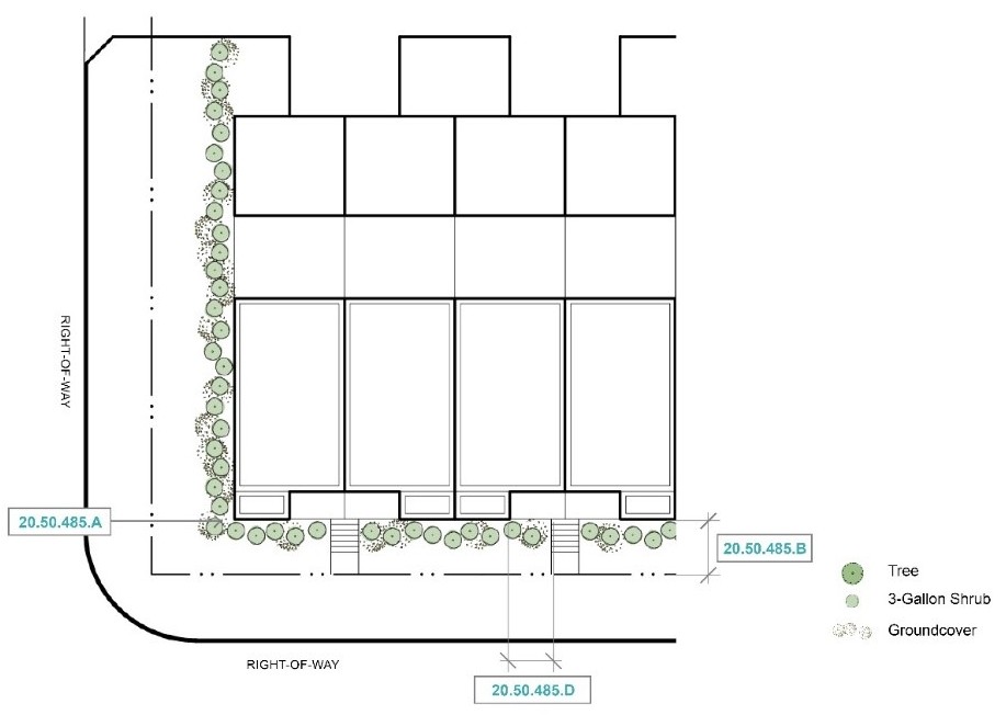
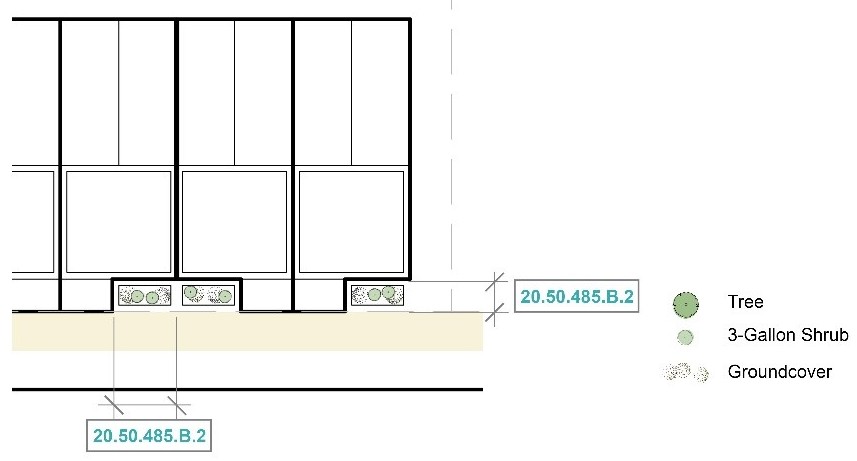
Front Facade Landscaping Illustrations
(Ord. 871 § 1 (Exh. A), 2020).
20.50.490 Landscaping along interior lot line – Standards.
A. Type I landscaping in a width determined by the setback requirement shall be included in all nonresidential development along any portion adjacent to single-family and multifamily residential zones or development. All other nonresidential development adjacent to other nonresidential development shall use Type II landscaping within the required setback. If the setback is zero feet then no landscaping is required.
B. Multifamily development shall use Type I landscaping when adjacent to single-family residential zones and Type II landscaping when adjacent to multifamily residential and commercial zoning within the required yard setback. Cottage housing developments shall include a five-foot Type II landscaping buffer combined with a six-foot-tall solid fence or wall along side and rear property lines. Single-family attached and mixed single-family developments shall use Type I landscaping when adjacent to R-4 or R-6 zoning, and Type II landscaping when adjacent to all other zoning districts. Single-family attached and mixed single-family developments that have a shared access drive with an abutting property are exempt from this requirement on the side with the shared access drive.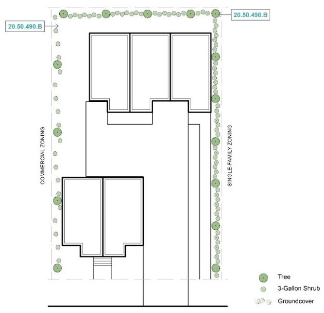
Single-Family Attached and Mixed Single-Family Interior Landscaping Illustration
C. A 20-foot width of Type I landscaping shall be provided for institutional and public facility development adjacent to single-family residential zones. Portions of the development that are unlit playgrounds, playfields, and parks are excluded.
D. Parking lots shall be screened from single-family residential uses by a fence, wall, plants or combination to block vehicle headlights.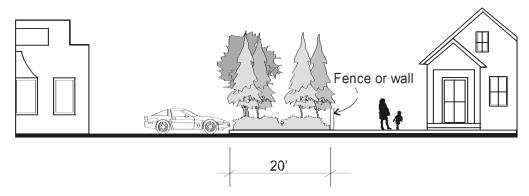
Figure 20.50.490(D): Example of parking screened from single-family house.
(Ord. 984 § 1 (Exh. A), 2023; Ord. 871 § 1 (Exh. A), 2020; Ord. 789 § 1 (Exh. A), 2018; Ord. 299 § 1, 2002; Ord. 238 Ch. V § 7(B-4), 2000).
20.50.500 Internal landscaping for parking area.
Required parking area landscaping shall include landscape areas that are located in areas within or adjacent to parking areas. However, landscaping designed to meet perimeter landscaping requirements cannot also be used to meet parking lot landscaping requirements.
A. Multifamily developments and cottage housing developments with common parking areas shall provide planting areas in parking lots at a rate of 20 square feet per parking stall.
B. Commercial, office, industrial or institutional developments shall provide landscaping at a rate of:
1. Twenty square feet per parking stall when 10 to 30 parking stalls are provided; or
2. Twenty-five square feet per parking stall when 31 or more parking stalls are provided.
C. Trees shall be provided and distributed throughout the parking area at a rate of one tree for every 10 parking stalls.
D. Permanent curbs or structural barriers shall be provided to protect shrubs and trees from vehicle bumpers. Landscaping under vehicle overhang shall not be included in required landscape area calculations.
E. Parking area landscaping shall require:
1. At least 60 square feet with a lineal dimension of no less than four feet;
2. Shrubs planted from five-gallon containers or at 24 inches in height and spaced no more than four feet apart on center;
3. Ground covers planted from minimally four-inch pots and spaced no more than 18 inches apart;
4. Trees planted at least 1.5 inches caliper in size;
5. Gaps in curbs are allowed for stormwater runoff; and
6. Natural drainage landscapes (such as rain gardens, biofiltration swales and bioretention planters) when designed in compliance with the stormwater design manual. (Ord. 984 § 1 (Exh. A), 2023; Ord. 669 § 1 (Exh. A), 2013; Ord. 654 § 1 (Exh. 1), 2013; Ord. 238 Ch. V § 7(B-5), 2000).
20.50.510 Alternative landscape design.
Alternative landscape designs may be allowed, subject to City approval, if the design accomplishes equal or better levels of Type I or II landscaping.
A. The average width of the perimeter landscape area may be reduced 25 percent along interior property lines where:
1. Berms at least three feet in height (2:1 slope) or walls and fences at least six feet in height are incorporated into the landscape design; or
2. Plant material that would be required is located elsewhere on site.
B. When an existing structure precludes installation of the required site perimeter landscape area then the plant material shall be incorporated on another portion of the site. (Ord. 238 Ch. V § 7(B-6), 2000).
20.50.520 General standards for landscape installation and maintenance.
A. Berms shall not exceed a slope of two horizontal feet to one vertical foot (2:1).
B. All new turf areas, except all-weather or sand-based athletic fields, shall be augmented with a two-inch layer of organic material cultivated a minimum of six inches deep or have an organic content of five percent or more to a depth of six inches.
C. Except as specifically outlined for turf areas in subsection (B) of this section, the organic content of soils in any landscape area shall be as necessary to provide adequate nutrient and moisture-retention levels for the establishment of plantings.
D. Landscape areas, except turf or areas of established ground cover, shall be covered with at least two inches of mulch to minimize evaporation.
E. Plant selection shall consider adaptability to climatic, geologic, and topographical conditions of the site. Preservation of existing vegetation is encouraged.
F. All plants shall conform to American Association of Nurserymen (AAN) grades and standards as published in the “American Standard for Nursery Stock” manual; provided, that existing healthy vegetation used to augment new plantings shall not be required to meet the standards of this manual.
G. Multiple-stemmed trees shall be permitted as an option to single-stemmed trees; provided, that such multiple-stemmed trees are at least 10 feet in height and not allowed within street rights-of-way.
H. When the width of any landscape strip is 20 feet or greater, the required trees shall be staggered to avoid the appearance of a single row of trees.
I. All fences shall be placed on the inward side of any required perimeter landscaping when adjacent to a public right-of-way and on the outward side of the required landscaping or on the property line when adjacent to private property.
J. Required street landscaping may be placed within Washington State rights-of-way subject to permission of the Washington State Department of Transportation.
K. New landscape material shall be indigenous plant species within areas of undisturbed vegetation, within critical areas or their buffers or within the protected area of significant trees; provided, that pesticide and chemical fertilizer may be restricted within these landscaped areas.
L. All landscaping shall be installed according to sound horticultural practices in a manner designed to encourage quick establishment and healthy plant growth. All landscaping shall either be installed or the installation shall be secured with a letter of credit, escrow, or performance bond for 125 percent of the value of the landscaping prior to the issuance of a certificate of occupancy for any building in such phase.
M. Trees and vegetation, fences, walls and other landscape elements shall be considered as elements of the project in the same manner as parking, building materials and other site details. The applicant, landowner or successors in interest shall be responsible for the regular maintenance of all landscaping elements in good condition.
N. Applicants shall provide a landscape maintenance and replacement agreement to the City prior to issuance of a certificate of occupancy.
O. Landscape plans and utility plans shall be coordinated. The placement of trees and large shrubs shall accommodate the location of required utilities both above and below ground. Location of plants and trees shall be based on the mature canopy and root zone. Root zone shall be determined using the International Society of Arboriculture’s recommended calculation for identifying tree protection area. Mature tree and shrub canopies may not reach an aboveground utility such as street lights and power lines. Mature tree and shrub root zones may overlap utility trenches as long as 80 percent of the root zone is unaffected.
P. Adjustment of plant location does not reduce the number of plants required for landscaping.
Q. Sight distance triangle for visual clearances shall be established and maintained. The criteria for sight distance and visual clearances are contained in and consistent with the Engineering Development Guide for all driveway exits and entrances and street corners. (Ord. 591 § 1 (Exh. A), 2010; Ord. 581 § 1 (Exh. 1), 2010; Ord. 238 Ch. V § 7(B-7), 2000).
Subchapter 8.
Signs
20.50.530 Purpose.
The purposes of this subchapter are:
A. To provide standards for the effective use of signs as a means of identification that enhances the aesthetics of business properties and economic viability.
B. To protect the public interest and safety by minimizing the possible adverse effects of signs on nearby properties and traffic safety.
C. To establish regulations for the type, number, location, size, and lighting of signs that are complementary with the building use and compatible with their surroundings. (Ord. 654 § 1 (Exh. 1), 2013; Ord. 299 § 1, 2002; Ord. 238 Ch. V § 8(A), 2000).
20.50.532 Permit required.
A. Except as provided in this chapter, no temporary or permanent sign may be constructed, installed, posted, displayed or modified without first obtaining a sign permit approving the proposed sign’s size, design, location, and display.
B. No permit is required for normal and ordinary maintenance and repair, and changes to the graphics, symbols, or copy of a sign, without affecting the size, structural design or height. Exempt changes to the graphics, symbols or copy of a sign must meet the standards for permitted illumination.
C. Installation or replacement of electronic changing message or reader board signs requires a permit and must comply with Exception 20.50.550(A)(2) and SMC 20.50.590.
D. Sign applications that propose to depart from the standards of this subchapter must receive an administrative design review approval under SMC 20.30.297 for all signs on the property as a comprehensive signage package.
E. Applications for property located within the Aurora Square Community Renewal Area, as defined by Resolution 333, shall be subject to SMC 20.50.620. (Ord. 712 § 1 (Exh. A), 2015; Ord. 695 § 1 (Exh. A), 2014; Ord. 654 § 1 (Exh. 1), 2013).
20.50.535 Thresholds – Required site improvements.
Repealed by Ord. 654. (Ord. 581 § 1 (Exh. 1), 2010; Ord. 515 § 1, 2008; Ord. 299 § 1, 2002).
20.50.540 Sign design.
A. Sight Distance. No sign shall be located or designed to interfere with visibility required by the City of Shoreline for the safe movement of pedestrians, bicycles, and vehicles.
B. Private Signs on City Right-of-Way. No private signs shall be located partially or completely in a public right-of-way unless a right-of-way permit has been approved consistent with Chapter 12.15 SMC and is allowed under SMC 20.50.540 through 20.50.610.
C. Sign Copy Area. Calculation of sign area shall use rectangular areas that enclose each portion of the signage such as words, logos, graphics, and symbols other than nonilluminated background. Sign area for signs that project out from a building or are perpendicular to street frontage are measured on one side even though both sides can have copy.
D. Building Addresses. Building addresses should be installed on all buildings consistent with SMC 20.70.250(C) and will not be counted as sign copy area.
E. Materials and Design. All signs, except temporary signs, must be constructed of durable, maintainable materials. Signs that are made of materials that deteriorate quickly or that feature impermanent construction are not permitted for permanent signage. For example, plywood or plastic sheets without a sign face overlay or without a frame to protect exposed edges are not permitted for permanent signage.
F. Illumination. Where illumination is permitted per Table 20.50.540(G) the following standards must be met:
1. Channel lettering or individual backlit letters mounted on a wall, or individual letters placed on a raceway, where light only shines through the copy.
2. Opaque cabinet signs where light only shines through copy openings.
3. Shadow lighting, where letters are backlit, but light only shines through the edges of the copy.
4. Neon signs.
5. All external light sources illuminating signs shall be less than six feet from the sign and shielded to prevent direct lighting from entering adjacent property.

Individual backlit letters (left image), opaque signs where only the light shines through the copy (center image), and neon signs (right image).
G. Table 20.50.540(G) – Sign Dimensions.
A property may use a combination of the four types of signs listed below.
Refer to SMC 20.50.620 for the Aurora Square Community Renewal Area sign regulations.
|
|
All Residential (R) Zones, MUR-35', Campus, PA 3 and TC-4 |
MUR-45', MUR-70', NB, CB and TC-3 (1) |
MB, TC-1 and TC-2 |
|---|---|---|---|
|
MONUMENT Signs: |
|||
|
Maximum Area Per Sign Face |
4 sq. ft. (home occupation, day care, adult family home, residential care facilities, bed and breakfast) 25 sq. ft. (nonresidential use, residential subdivision or multifamily development) 32 sq. ft. (schools and parks) |
50 sq. ft. |
100 sq. ft. |
|
Maximum Height |
42 inches |
6 feet |
12 feet |
|
Maximum Number Permitted |
1 per street frontage |
1 per street frontage |
1 per street frontage |
|
Two per street frontage if the frontage is greater than 250 ft. and each sign is minimally 150 ft. apart from other signs on same property. |
|||
|
Illumination |
Permitted |
Permitted |
|
|
BUILDING-MOUNTED SIGNS: |
|||
|
Maximum Sign Area |
Same as for monument signs |
25 sq. ft. (each tenant) Building Directory 10 sq. ft. Building Name Sign 25 sq. ft. |
50 sq. ft. (each tenant) Building Directory 10 sq. ft. Building Name Sign 25 sq. ft. |
|
Maximum Height |
Not to extend above the building parapet, soffit, or eave line of the roof. If perpendicular to building then 9-foot clearance above walkway. |
||
|
Number Permitted |
1 per street frontage |
1 per business per facade facing street frontage or parking lot. |
|
|
Illumination |
Permitted |
Permitted |
Permitted |
|
UNDER-AWNING SIGNS |
|||
|
Maximum Sign Area |
6 sq. ft. (Nonresidential uses, schools, residential subdivision or multifamily development) |
12 sq. ft. |
|
|
Minimum Clearance from Grade |
9 feet |
||
|
Maximum Height (ft.) |
Not to extend above or beyond awning, canopy, or other overhanging feature of a building under which the sign is suspended |
||
|
Number Permitted |
1 per business |
1 per business per facade facing street frontage or parking lot. |
|
|
Illumination |
Prohibited |
Permitted |
|
|
DRIVEWAY ENTRANCE/EXIT: |
|||
|
Maximum Sign Area |
4 sq. ft. (Nonresidential uses, schools, residential subdivision or multifamily development) |
8 sq. ft. |
|
|
Maximum Height |
42 inches |
48 inches |
|
|
Number Permitted |
1 per driveway |
||
|
Illumination |
Permitted |
Permitted |
|
Exceptions to Table 20.50.540(G):
(1) The monument sign standards for MB, TC-1, and TC-2 apply on properties zoned NB, CB, and TC-3 where the parcel has frontage on a State Route, including SR 99, 104, 522, and 523.
(2) Sign mounted on fence or retaining wall may be substituted for building-mounted or monument signs so long as it meets the standards for that sign type and does not increase the total amount of allowable signage for the property.
H. Window Signs. Window signs are permitted to occupy maximum 25 percent of the total window area in zones MUR-45', MUR-70', NB, CB, MB, TC-1, TC-2, and TC-3. Window signs are exempt from permit if non-illuminated and do not require a permit under the building code.
I. A-Frame Signs. A-frame, or sandwich board, signs are exempt from permit but allowed only in the MUR-45', MUR-70', NB, CB, MB, and TC-1, TC-2, and TC-3 zones subject to the following standards:
1. Maximum one sign per business;
2. Must be directly in front of the business with the business’ name and may be located on the City right-of-way where the property on which the business is located has street frontage;
3. Cannot be located within the required clearance for sidewalks and internal walkways as defined for the specific street classification or internal circulation requirements;
4. Shall not be placed in landscaping, within two feet of the street curb where there is on-street parking, public walkways, or crosswalk ramps;
5. Maximum two feet wide and three feet tall, not to exceed six square feet in area;
6. No lighting of signs is permitted;
7. All signs shall be removed from display when the business closes each day; and
8. A-frame/sandwich board signs are not considered structures.
J. Other Residential Signs. One sign maximum for home occupations, day cares, adult family homes and bed and breakfasts which are located in residential (R) zones, MUR-35' or TC-4 not exceeding four square feet in area is exempt from permit. It may be mounted on the residence, fence or freestanding on the property, but must be located on the subject property and not on the City right-of-way or adjacent parcels. (Ord. 824 § 1 (Exh. A), 2018; Ord. 767 § 1 (Exh. A), 2017; Ord. 706 § 1 (Exh. A), 2015; Ord. 654 § 1 (Exh. 1), 2013; Ord. 560 § 4 (Exh. A), 2009; Ord. 352 § 1, 2004; Ord. 299 § 1, 2002; Ord. 238 Ch. V § 8(B), 2000).
20.50.550 Prohibited signs.
A. Spinning devices; flashing lights; searchlights, electronic changing messages or reader board signs.
Exception 20.50.550(A)(1): Traditional barber pole signs allowed only in MUR-45', MUR-70', NB, CB, MB and TC-1 and 3 zones.
Exception 20.50.550(A)(2): Electronic changing message or reader boards are permitted in CB and MB zones if they do not have moving messages or messages that change or animate at intervals less than 20 seconds. Replacement of existing, legally established electronic changing message or reader boards in existing signs is allowed, but the intervals for changing or animating messages must meet the provisions of this section, as well as SMC 20.50.532 and 20.50.590. Maximum one electronic changing message or reader board sign is permitted per parcel. Digital signs which change or animate at intervals less than 20 seconds will be considered blinking or flashing and are not allowed.
B. Portable signs, except A-frame signs as allowed by SMC 20.50.540(I).
C. Outdoor off-premises advertising signs (billboards).
D. Signs mounted on the roof.
E. Pole signs.
F. Backlit awnings used as signs.
G. Pennants; swooper flags; feather flags; pole banners; inflatables; and signs mounted on vehicles. (Ord. 706 § 1 (Exh. A), 2015; Ord. 695 § 1 (Exh. A), 2014; Ord. 654 § 1 (Exh. 1), 2013; Ord. 631 § 1 (Exh. 1), 2012; Ord. 560 § 4 (Exh. A), 2009; Ord. 369 § 1, 2005; Ord. 299 § 1, 2002; Ord. 238 Ch. V § 8(C), 2000).
20.50.560 Monument signs.
A. A solid-appearing base is required under at least 75 percent of sign width from the ground to the base of the sign or the sign itself may start at grade.
B. Monument signs must be double-sided if the back is visible from the street.
C. Use materials and architectural design elements that are consistent with the architecture of the buildings. (Ord. 706 § 1 (Exh. A), 2015; Ord. 654 § 1 (Exh. 1), 2013; Ord. 352 § 1, 2004; Ord. 299 § 1, 2002; Ord. 238 Ch. V § 8(D-1), 2000).
20.50.570 Building-mounted signs.
A. Building signs shall not cover building trim or ornamentation.
B. Projecting, awning, canopy, and marquee signs (above awnings) shall clear sidewalk by nine feet and not project beyond the awning extension or eight feet, whichever is less. These signs may project into public rights-of-way, subject to City approval. (Ord. 706 § 1 (Exh. A), 2015; Ord. 654 § 1 (Exh. 1), 2013; Ord. 560 § 4 (Exh. A), 2009; Ord. 299 § 1, 2002; Ord. 238 Ch. V § 8(D-2), 2000).
20.50.580 Under-awning signs.
These signs may project into public rights-of-way, subject to City approval. (Ord. 706 § 1 (Exh. A), 2015; Ord. 654 § 1 (Exh. 1), 2013; Ord. 299 § 1, 2002; Ord. 238 Ch. V § 8(D-3), 2000).
20.50.590 Nonconforming signs.
A. Nonconforming signs shall not be altered in size, shape, height, location, or structural components without being brought to compliance with the requirements of this Code. Repair and maintenance are allowable, but may require a sign permit if structural components require repair or replacement.
B. Billboards now in existence are declared nonconforming and may remain subject to the following restrictions:
1. Shall not be increased in size or elevation, nor shall be relocated to another location.
2. Installation of electronic changing message or reader boards in existing billboards is prohibited.
3. Shall be kept in good repair and maintained.
4. Any outdoor advertising sign not meeting these restrictions shall be removed within 30 days of the date when an order by the City to remove such sign is given.
C. Electronic changing message or reader boards may not be installed in existing, nonconforming signs without bringing the sign into compliance with the requirements of this code, including Exception 20.50.550(A)(2).
Exception 20.50.590(C)(1): Regardless of zone, replacement or repair of existing, legally established electronic changing message or reader boards is allowed without bringing other nonconforming characteristics of a sign into compliance, so long as the size of the reader board does not increase and the provisions of SMC 20.50.532 and the change or animation provisions of Exception 20.50.550(A)(2) are met.
(Ord. 706 § 1 (Exh. A), 2015; Ord. 695 § 1 (Exh. A), 2014; Ord. 654 § 1 (Exh. 1), 2013; Ord. 299 § 1, 2002; Ord. 238 Ch. V § 8(E), 2000).
20.50.600 Temporary signs.
A. General Requirements. Certain temporary signs not exempted by SMC 20.50.610 shall be allowable under the conditions listed below. All signs shall be nonilluminated. Any of the signs or objects included in this section are illegal if they are not securely attached, create a traffic hazard, or are not maintained in good condition. No temporary signs shall be posted or placed upon public property unless explicitly allowed or approved by the City through the applicable right-of-way permit. Except as otherwise described under this section, no permit is necessary for allowed temporary signs.
B. Temporary On-Premises Business Signs. Temporary banners are permitted in zones MUR-45', MUR-70', NB, CB, MB, TC-1, TC-2, and TC-3 or for schools and houses of worship in all residential zones to announce sales or special events such as grand openings, or prior to the installation of permanent business signs. Such temporary business signs shall:
1. Be limited to not more than one sign per street frontage per business, place of worship, or school;
2. Be limited to 32 square feet in area;
3. Not be displayed for a period to exceed a total of 60 calendar days effective from the date of installation and not more than four such 60-day periods are allowed in any 12-month period; and
4. Be removed immediately upon conclusion of the sale, event or installation of the permanent business signage.
C. Construction Signs. Banner or rigid signs (such as plywood or plastic) identifying the architects, engineers, contractors or other individuals or firms involved with the construction of a building or announcing purpose for which the building is intended. Total signage area for both new construction and remodeling shall be a maximum of 32 square feet. Signs shall be installed only upon City approval of the development permit, new construction or tenant improvement permit and shall be removed within seven days of final inspection or expiration of the building permit.
D. Temporary signs not allowed under this section and which are not explicitly prohibited may be considered for approval under a temporary use permit under SMC 20.30.295 or as part of administrative design review for a comprehensive signage plan for the site. (Ord. 706 § 1 (Exh. A), 2015; Ord. 695 § 1 (Exh. A), 2014; Ord. 654 § 1 (Exh. 1), 2013; Ord. 299 § 1, 2002; Ord. 238 Ch. V § 8(F), 2000).
20.50.610 Exempt signs.
The following are exempt from the provisions of this chapter, except that all exempt signs must comply with SMC 20.50.540(A), Sight Distance, and SMC 20.50.540(B), Private Signs on City Right-of-Way:
A. Historic site markers or plaques and gravestones.
B. Signs required by law, including but not limited to:
1. Official or legal notices issued and posted by any public agency or court; or
2. Traffic directional or warning signs.
C. Plaques, tablets or inscriptions indicating the name of a building, date of erection, or other commemorative information, which are an integral part of the building structure or are attached flat to the face of the building, not illuminated, and do not exceed four square feet in surface area.
D. Incidental signs, which shall not exceed two square feet in surface area; provided, that said size limitation shall not apply to signs providing directions, warnings or information when established and maintained by a public agency.
E. State or Federal flags.
F. Religious symbols.
G. The flag of a commercial institution, provided no more than one flag is permitted per business premises; and further provided, the flag does not exceed 20 square feet in surface area.
H. Neighborhood identification signs with approved placement and design by the City.
I. Neighborhood and business block watch signs with approved placement of standardized signs acquired through the City of Shoreline Police Department.
J. Plaques, signs or markers for landmark tree designation with approved placement and design by the City.
K. Real estate signs not exceeding four square feet and five feet in height in residential zones and 24 square feet and seven feet in height in commercial zones located on subject parcel(s), not on City right-of-way. A single fixed sign may be located on the property to be sold, rented or leased, and shall be removed within seven days from the completion of the sale, lease or rental transaction.
L. City-sponsored event signs up for no more than two weeks.
M. Gateway signs constructed in compliance with the Gateway Policy and Guideline Manual.
N. Parks signs constructed in compliance with the Parks Sign Design Guidelines and Installation Details as approved by the Parks Board and the Director. Departures from these approved guidelines may be reviewed as departures through the administrative design review process and may require a sign permit for installation.
O. Garage sale signs not exceeding four square feet per sign face and not advertising for a period longer than 48 hours.
P. City land-use public notification signs.
Q. Menu signs used only in conjunction with drive-through windows, and which contains a price list of items for sale at that drive-through establishment. Menu signs cannot be used to advertise the business to passersby: text and logos must be of a size that can only be read by drive-through customers. A building permit may be required for menu signs based on the size of the structure proposed.
R. Campaign signs that comply with size, location and duration limits provided in Shoreline Administrative Rules. (Ord. 695 § 1 (Exh. A), 2014; Ord. 654 § 1 (Exh. 1), 2013; Ord. 319 § 1, 2003; Ord. 299 § 1, 2002; Ord. 238 Ch. V § 8(G), 2000).
20.50.620 Shoreline Place (Aurora Square Community Renewal Area) sign standards.
A. Purpose. The purposes of this section are:
1. To provide standards for the effective use of signs as a means of business identification that enhances the aesthetics of business properties and economic viability.
2. To provide a cohesive and attractive public image of the Shoreline Place development.
3. To protect the public interest and safety by minimizing the possible adverse effects of signs.
4. To establish regulations for the type, number, location, size, and lighting of signs that are complementary with the building use and compatible with their surroundings.
B. Location Where Applicable. Map 20.50.620.B illustrates the Aurora Square CRA where the sign standards defined in this section apply.
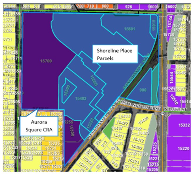
C. Definitions. The following definitions apply to this section:
|
Building-Mounted Sign |
A sign permanently attached to a building, including flush-mounted, projecting, awning, canopy, or marquee signs. Under-awning or blade signs are regulated separately. |
|
CRA |
Aurora Square Community Renewal Area, as defined by Resolution 333, the Aurora Square Community Renewal Area Plan, and Map 20.50.620.B. |
|
Monument Sign |
A freestanding sign with a solid-appearing base under at least 75 percent of sign width from the ground to the base of the sign or the sign itself may start at grade. Monument signs may also consist of cabinet or channel letters mounted on a fence, freestanding wall, or retaining wall where the total height of the structure meets the limitations of this code. |
|
Portable Sign |
A sign that is readily capable of being moved or removed, whether attached or affixed to the ground or any structure that is typically intended for temporary display. |
|
Pylon Sign |
A freestanding sign with a visible support structure or with the support structure enclosed with a pole cover. |
|
Shoreline Place |
That portion of the Aurora Square CRA envisioned in the CRA Renewal Plan as interrelated retail, service, and residential use. |
|
Shoreline Place Signage Design Guidelines |
The set of design standards adopted by the City that specifies the common name, logo, taglines, fonts, colors, and sign standards used on freestanding signs throughout Shoreline Place. |
|
Temporary Sign |
A sign that is only permitted to be displayed for a limited period of time, after which it must be removed. |
|
Under-Awning Sign |
A sign suspended below a canopy, awning or other overhanging feature of a building. |
|
Wayfinding Sign Post |
A sign with multiple individual panels acting as directional pointers that are suspended from a freestanding post. |
|
Window Sign |
A sign applied to a window or mounted or suspended directly behind a window. |
D. Permit Required.
1. Except as provided in this section, no permanent sign may be constructed, installed, posted, displayed or modified without first obtaining a sign permit approving the proposed sign’s size, design, location, and, where applicable, adherence to the Shoreline Place signage design guidelines.
2. No permit is required for normal and ordinary maintenance and repair, and changes to the graphics, symbols, or copy of a sign, without affecting the size, structural design or height. Exempt changes to the graphics, symbols or copy of a sign must meet the standards defined herein.
3. All pylon, monument, and wayfinding signs within Shoreline Place shall conform to the Shoreline Place signage design guidelines. For all other types of unique, sculptural or artistic signs, if an applicant seeks to depart from the standards of this section, the applicant must receive an administrative design review approval under SMC 20.30.297.
E. Sign Design.
1. Sight Distance. No sign shall be located or designed to interfere with visibility required by the City of Shoreline for the safe movement of pedestrians, bicycles, and vehicles.
2. Private Signs on City Right-of-Way. No portion of a private sign, above or below ground, shall be located in a public right-of-way unless a right-of-way permit has been approved consistent with Chapter 12.15 SMC and is allowed under SMC 20.50.540 through 20.50.610.
3. Sign Copy Area. Calculation of sign area for channel letters or painted signs shall be the total area of all rectangular areas (each drawn with a maximum of six right angles) that enclose each portion of the signage such as words, logos, graphics, and symbols other than nonilluminated background. Sign area for cabinet signs shall be the entire face of the cabinet. Sign area for signs that project out from a building or are perpendicular to street frontage are measured on one side even though both sides can have copy of equal size. Supporting structures such as sign bases and columns are not included in sign area; provided, that they contain no lettering or graphics except for addresses.
4. Building Addresses. Building addresses should be installed on all buildings consistent with SMC 20.70.250(C) and will not be counted as sign copy area.
5. Materials and Design. All signs, except temporary signs, must be constructed of durable, maintainable materials. Signs that are made of materials that deteriorate quickly or that feature impermanent construction are not permitted for permanent signage. For example, plywood or plastic sheets without a sign face overlay or without a frame to protect exposed edges are not permitted for permanent signage.
6. Shoreline Place Signage Design Guidelines. Design and content of the pylon, monument, and wayfinding sign posts within Shoreline Place shall conform to the Shoreline Place signage design guidelines. In addition, all other permanent or temporary signage or advertising displaying the common name, logo, colors, taglines, or fonts of Shoreline Place center identity shall comply with the Shoreline Place signage design guidelines.
7. Illumination. Where illumination is permitted per Table 20.50.620.E.8 the following standards must be met:
a. Channel lettering or individual backlit letters mounted on a wall, or individual letters placed on a raceway, where light only shines through the copy.
b. Opaque cabinet signs where light only shines through copy openings.
c. Shadow lighting, where letters are backlit, but light only shines through the edges of the copy.
d. Neon signs.
e. All external light sources illuminating signs shall be less than six feet from the sign and shielded to prevent direct lighting from entering adjacent property.
f. Building perimeter/outline lighting is allowed for theaters only.

Individual backlit letters (left image), opaque signs where only the light shines through the copy (center image), and neon signs (right image).
8. Sign Specifications.
|
MONUMENT SIGNS |
|
|
Maximum Sign Copy Area |
100 square feet. The monument sign must be double-sided if the back of the sign is visible from the street. |
|
Maximum Structure Height |
8 feet. |
|
Maximum Number Permitted per Parcel per Public Street Frontage |
1 sign – up to 250 feet of street frontage. 2 signs – parcels with more than 250 but less than 500 feet of street frontage. 3 signs – 500 feet or more of street frontage. |
|
Sign Design |
At least 15 percent of the sign copy area shall be used for center identification of Shoreline Place. Individual business listings, if shown, shall not include logos and shall be a common color scheme conforming to the Shoreline Place signage design guidelines but may include any font. |
|
Spacing |
Signs must be separated by at least 100 feet from another monument or pylon sign on the same parcel or 50 feet from another monument or pylon sign on an adjacent parcel. |
|
Illumination |
Permitted. |
|
MONUMENT SIGNS OUTSIDE OF SHORELINE PLACE |
|
|
Maximum Sign Copy Area |
50 square feet. |
|
Maximum Structure Height |
6 feet. |
|
Maximum Number Permitted |
1 per parcel with up to 250 feet of street frontage, 2 for parcels with 250 feet or more of frontage on the same street. Signs must be separated by at least 100 feet from any other monument or pylon sign. |
|
Sign Design |
Conformance to the Shoreline Place signage design guidelines is optional. |
|
Illumination |
Permitted. |
|
WAYFINDING SIGN POSTS |
|
|
Maximum Sign Copy Area |
2 square feet per business listing; no limit on number of businesses displayed. |
|
Maximum Structure Height |
10 feet. |
|
Maximum Number Permitted |
No limit. |
|
Sign Design |
Individual business listings shall not include logos and shall be in a single common color conforming to the Shoreline Place signage design guidelines. There is no restriction on font. Directional arrow background may be of a contrasting color. |
|
Location |
Throughout Shoreline Place. Must be set back at least 25 feet from the curb line of public streets. |
|
Illumination |
Permitted. |
|
PYLON SIGNS |
|
|
Maximum Sign Copy Area |
300 square feet. |
|
Maximum Structure Height |
35 feet. |
|
Maximum Number Permitted per Parcel |
2 pylon signs allowed per parcel over 5 acres. |
|
Sign Design |
At least 15 percent of the sign copy area shall be used for center identification of Shoreline Place. Individual business listings, if shown, shall not include logos and shall be a common color scheme conforming to the Shoreline Place signage design guidelines but may include any font. |
|
Location |
Signs may be located on public street frontages that are directly across from properties with Mixed Business (MB) zoning. Signs must be separated by at least 100 feet from another monument or pylon sign on the same parcel or 50 feet from another monument or pylon sign on an adjacent parcel. |
|
Illumination |
Permitted. |
|
BUILDING-MOUNTED SIGNS |
|
|
Maximum Sign Copy Area |
Ground Floor Storefronts: 1.5 square feet of sign area per lineal foot of storefront that contains a public entrance. Ground Floor Side/Rear Walls without Public Entrances: 1 square foot of sign area per lineal foot of wall fronting a tenant space if the wall meets one of these standards: 1) Transparent glazing between the heights of 3 feet and 8 feet along at least 50 percent of the tenant space; or 2) A trellis with live, irrigated landscaping along at least 50 percent of the tenant space; or 3) Architectural detailing consistent with the other building facades such as awnings, canopies, changes in building material, and modulation. Residential Buildings: 2 elevations may have sign area equal to 2.5 percent of the building elevation fronting the residential use or a maximum of 500 square feet, whichever is less. |
|
Maximum Structure Height |
Not limited. Projecting, awning, canopy, and marquee signs (above awnings) shall clear sidewalk by 9 feet and not project beyond the awning extension or 8 feet, whichever is less. These signs may project into public rights-of-way, subject to City approval. |
|
Projecting Signs |
Maximum of 1 projecting sign per public entrance. Maximum size is 4 feet by 3 feet or 15 percent of the business’s maximum sign copy area, whichever is smaller. |
|
Number Permitted |
The maximum sign copy area per business may be distributed into multiple wall, projecting, awning, canopy or marquee signs; provided, that the aggregate sign area is equal to or less than the maximum allowed sign copy area. Signs must be placed on the building elevation used to calculate their maximum sign copy area. |
|
Sign Design |
Individual business building-mounted signs do not need to meet the Shoreline Place Design Guidelines for color or font. |
|
Illumination |
Permitted. |
|
UNDER-AWNING SIGNS |
|
|
Maximum Sign Copy Area |
12 square feet which does not count against the maximum sign copy area per business. |
|
Minimum Clearance from Grade |
8 feet. |
|
Maximum Structure Height |
Not to extend above or beyond awning, canopy, or other overhanging feature of a building under which the sign is suspended. Signs may project into the public right-of-way subject to City approval. |
|
Number Permitted |
1 per public entrance. |
|
Sign Design |
Individual business under-awning signs do not need to meet the Shoreline Place Design Guidelines for color or font. |
|
Illumination |
External only. |
9. Window Signs. Window signs are permitted to occupy maximum 25 percent of the total window area. Window signs are exempt from permit if nonilluminated and do not require a permit under the building code.
10. A-Frame Signs. A-frame, or sandwich board, signs are exempt from permit but subject to the following standards:
a. Maximum one sign per residential building;
b. May not be located on the City right-of-way;
c. Cannot be located within the required clearance for sidewalks and internal walkways as defined for the specific street classification or internal circulation requirements;
d. Shall not be placed in landscaping, within two feet of the street curb where there is on-street parking, public walkways, or crosswalk ramps;
e. Maximum two feet wide and three feet tall, not to exceed six square feet in area;
f. No lighting of signs is permitted;
g. All signs shall be removed from display when the business closes each day; and
h. A-frame/sandwich board signs are not considered structures.
11. Retail Leasing Signs. Signs are exempt from permit but subject to the following standards:
a. Maximum one sign per public street frontage per parcel;
b. May not be located on the City right-of-way;
c. Cannot be located within the required clearance for sidewalks and internal walkways as defined for the specific street classification or internal circulation requirements;
d. Shall not be placed within two feet of the street curb where there is on-street parking, public walkways, or crosswalk ramps;
e. Maximum sign area of eight feet wide and four feet tall plus support posts, total height not to exceed eight feet;
f. No lighting of signs is permitted.
12. Binding Site Plans. Signage allowances shall be calculated for the binding site plan as a whole without regard to interior lot lines as it is considered to function as one site.
F. Prohibited Signs.
1. Spinning devices; flashing lights; searchlights; or reader board signs. Traditional barber pole signs allowed.
2. Portable signs, except A-frame signs as allowed by subsection (E)(10) of this section.
3. Outdoor off-premises advertising signs (billboards).
4. Signs mounted on the roof or projecting above the parapet of the building wall on which it is mounted.
5. Inflatables.
6. Signs mounted on vehicles.
G. Nonconforming Signs.
1. No business may be listed on a pylon, monument, or wayfinding sign until any existing nonconforming freestanding sign listing that business is removed or brought into compliance with the requirements of this code. All pylon signs in Shoreline Place existing on August 10, 2015, are considered nonconforming and shall be removed by September 1, 2017. The City reserves the right to assess the property owner up to $100.00 per day for failure to remove or bring into compliance such nonconforming signs.
2. Nonconforming signs shall not be altered in size, shape, height, location, or structural components without being brought to compliance with the requirements of this code. Repair and maintenance are allowable, but may require a sign permit if structural components require repair or replacement.
H. Temporary Signs.
1. General Requirements. Certain temporary signs not exempted by SMC 20.50.610 shall be allowable under the conditions listed below. All signs shall be nonilluminated. Any of the signs or objects included in this section are illegal if they are not securely attached, create a traffic hazard, or are not maintained in good condition. No temporary signs shall be posted or placed upon public property unless explicitly allowed or approved by the City through the applicable right-of-way permit. Except as otherwise described under this section, no permit is necessary for allowed temporary signs.
2. Temporary On-Premises Business Signs. Temporary banners shall:
a. Be limited to one sign for businesses under 10,000 square feet and two signs for businesses larger than 10,000 square feet;
b. Be limited to 32 square feet in area; and
c. Not be displayed for a period to exceed a total of 60 calendar days effective from the date of installation and not more than two such 60-day periods are allowed in any 12-month period.
3. Construction Signs. Banner or rigid signs (such as plywood or plastic) for buildings which are under construction. Total signage area shall be a maximum of 32 square feet. Signs shall be installed only upon City approval of the development permit, new construction or tenant improvement permit and shall be removed within seven days of final inspection or expiration of the building permit.
4. Feather flags and pennants displayed for no more than 14 days prior and two days after community events.
5. Pole banner signs that are changed semi-annually and mounted on privately owned light poles only.
6. Temporary signs not allowed under this section and which are not explicitly prohibited may be considered for approval under a temporary use permit under SMC 20.30.295 or as part of administrative design review for a comprehensive signage plan for the site. (Ord. 897 § 1 (Exh. A), 2021; Ord. 712 § 1 (Exh. A), 2015).
Subchapter 9.
Deep Green Incentive Program (DGIP)
20.50.630 Deep Green Incentive Program (DGIP).
A. Purpose. The purpose of this section is to establish an incentive program for Living and Deep Green Buildings in the City of Shoreline. The goal of the DGIP is to encourage development that meets the International Living Future Institute’s (ILFI) Living Building ChallengeTM, Living Community ChallengeTM, Petal RecognitionTM, or Zero EnergyTM (ZE) programs; Built Green’s Emerald StarTM 5-StarTM, or 4-StarTM programs; the US Green Building Council’s (USGBC) Leadership in Energy and Environmental DesignTM (LEED) Platinum program; Passive House Institute USTM’s PHIUS+ or PHIUS+ Source Zero programs; and/or the Salmon SafeTM program by:
1. Encouraging development that will serve as a model for other projects throughout the city and region resulting in the construction of more Living and Deep Green Buildings; and
2. Allowing for departures from Code requirements to remove regulatory barriers.
B. Project Qualification.
1. Application Requirements. In order to request exemptions, waivers, or other incentives through the Deep Green Incentive Program, the applicant or owner shall submit a summary demonstrating how their project will meet each of the requirements of the relevant certification program, such as including an overall design concept, proposed energy balance, proposed water balance, and descriptions of innovative systems.
2. Qualification Process. An eligible project shall qualify for the DGIP upon determination by the Director that it has submitted a complete application pursuant to SMC 20.30.297, Administrative Design Review (Type A), and has complied with the application requirements of this subsection.
3. The project must be registered with the appropriate third-party certification entity such as the International Living Future Institute, Built Green, US Green Building Council, Passive House Institute US, or Salmon Safe.
4. Projects requesting departures under the DGIP shall meet the current version of the appropriate certification program, which will qualify them for one of the following tiered packages of incentives:
a. Tier 1 – Living Building Challenge or Living Community Challenge Certification: achieve all of the Imperatives of the ILFI programs;
b. Tier 2 – Emerald Star or Petal Certification: satisfy requirements of Built Green program or three or more ILFI Petals, including at least one of the following: water, energy, or materials;
c. Tier 3 – LEED Platinum, 5-Star, PHIUS+ Source Zero plus Salmon Safe, or ZE plus Salmon Safe: satisfy requirements of the respective USGBC, Built Green, PHIUS, ILFI, and/or Salmon Safe programs. The addition of Salmon Safe certification to PHIUS+ Source Zero or ZE projects is not required for detached single-family projects; or
d. Tier 4 – PHIUS+ or 4-Star: achieve all requirements of the PHIUS or Built Green programs.
C. Director’s Determination. All Shoreline Deep Green Incentive Program projects are subject to review by the Director under SMC 20.30.297. Any departures from the Shoreline Development Code (SMC Title 20) must be approved by the Director prior to submittal of building permit application.
D. Incentives. A project qualifying for the Shoreline Deep Green Incentive Program will be granted the following tiered incentive packages, based on the certification program for which they are applying:
1. A project qualifying for Tier 1 – Living Building Challenge or Living Community Challenge may be granted a waiver of up to 100 percent City-imposed preapplication and permit application fees. A project qualifying for Tier 2 – Emerald Star or Petal Recognition may be granted a waiver of up to 75 percent of City-imposed application fees. A project qualifying for Tier 3 – LEED Platinum, 5-Star, PHIUS+ Source Zero/Salmon Safe, or ZE/Salmon Safe may be granted a waiver of up to 50 percent of City-imposed application fees. A project qualifying for Tier 4 – PHIUS+ or 4-Star may be granted a waiver of up to 25 percent of City-imposed application fees.
2. Projects qualifying for the DGIP may be granted a reduced Transportation Impact Fee based on a project-level Transportation Impact Analysis.
3. Departures from Development Code requirements when in compliance with subsection E of this section.
4. Expedited permit review without additional fees provided in Chapter 3.01 SMC.
E. Departures from Development Code Requirements. The following requirements must be met in order to approve departures from Development Code requirements:
1. The departure would result in a development that meets the goals of the Shoreline Deep Green Incentive Program and would not conflict with the health and safety of the community. In making this recommendation, the Director shall consider the extent to which the anticipated environmental performance of the building would be substantially compromised without the departures.
2. A Neighborhood Meeting is required for projects departing from standards in the R-4 or R-6 zones.
3. Departures from the following regulations may be granted for projects qualifying for the Shoreline Deep Green Incentive Program:
a. SMC 20.50.020, Residential density limits.
i. Tier 1 – Living Building Challenge or Living Community Challenge Certification: up to 100 percent bonus for the base density allowed under zoning designation for projects meeting the full Challenge criteria;
ii. Tier 2 – Emerald Star or Living Building Petal Certification: up to 75 percent bonus for the base density allowed under zoning designation for projects meeting the program criteria;
iii. Tier 3 – LEED Platinum, 5-Star, or PHIUS+ Source Zero/Salmon Safe or ZE/Salmon Safe Certification: up to 50 percent bonus for the base density allowed under zoning designation for projects meeting the program criteria;
iv. Tier 4 – PHIUS+ or 4-Star: up to 25 percent bonus for the base density allowed under zoning designation for projects meeting the program criteria.
Minimum lot size of 10,000 square feet is required in all zones with a density maximum in order to request a density bonus. Density bonus is not available in R-4 and R-6 zones. Any additional units granted would be required to be built to the same green building standard as the first.
b. SMC 20.50.390, Parking requirements (not applicable in R-4 and R-6 zones):
i. Tier 1 – Living Building Challenge or Living Community Challenge Certification: up to 50 percent reduction in parking required under SMC 20.50.390 for projects meeting the full Challenge criteria;
ii. Tier 2 – Emerald Star or Living Building Petal Certification: up to 35 percent reduction in parking required under SMC 20.50.390 for projects meeting the program criteria;
iii. Tier 3 – LEED Platinum, 5-Star, PHIUS+ Source Zero/Salmon Safe, or ZE/Salmon Safe Certification: up to 20 percent reduction in parking required under SMC 20.50.390 for projects meeting the program criteria;
iv. Tier 4 – PHIUS+ or 4-Star Certification: up to five percent reduction in parking required under SMC 20.50.390 for projects meeting the program criteria.
c. Lot coverage standards, as determined necessary by the Director;
d. Use provisions, as determined necessary by the Director;
e. Standards for storage of solid-waste containers;
f. Standards for structural building overhangs and minor architectural encroachments into the right-of-way;
g. Structure height bonus up to 10 feet for development in a zone with height limit of 35 feet. Height bonus is not available in R-4, R-6, R-8, and MUR-35’ zones. Structure height bonus up to 20 feet for development in a zone with a height limit of 45 feet or greater; and
h. A rooftop feature may extend above the structure height bonus provided in SMC 20.50.020 or 20.50.050 if the extension is consistent with the applicable standards established for that rooftop feature within the zone.
F. Compliance with Minimum Standards.
1. For projects requesting departures, fee waivers, or other incentives under the Deep Green Incentive Program, the building permit application shall include a report from the design team demonstrating how the project is likely to achieve the elements of the program through which it intends to be certified.
2. For projects applying for an ILFI certification (Tiers 1, 2, or 3), after construction and within six months of issuance of the Certificate of Occupancy, the applicant or owner must show proof that an LBC Preliminary Audit has been scheduled; such as a paid invoice and date of scheduled audit. After construction and within 12 months of issuance of Certificate of Occupancy, the applicant or owner must show a preliminary audit report from ILFI demonstrating project compliance with the Place, Materials, Indoor Air Quality, and Beauty/Inspiration Imperatives that do not require a performance period.
3. For projects aiming for Built Green Emerald Star (Tier 2), 5-Star (Tier 3), or 4-Star (Tier 4) certification, after construction and within six months of issuance of the Certificate of Occupancy, the applicant or owner must show proof that the project successfully met Built Green certification by way of the Certificate of Merit from the program.
4. For projects pursuing LEED certification (Tier 3), the applicant or owner must show, after construction and within six months of issuance of the Certificate of Occupancy, that the project has successfully completed the LEED Design Review phase by way of the final certification report.
5. For projects pursuing PHIUS+ (Tier 4) or PHIUS+ Source Zero certification (Tier 3), the applicant or owner must show, after construction and within six months of issuance of the Certificate of Occupancy, that the project has successfully obtained the PHIUS+ or PHIUS+ Source Zero certification.
6. For projects pursuing Salmon Safe certification (Tier 3 in conjunction with ZE or PHIUS+ Source Zero when applicable), the applicant or owner must show, after construction and within six months of issuance of the Certificate of Occupancy, that the project has successfully obtained the Salmon Safe Certificate.
7. No later than two years after issuance of a final Certificate of Occupancy for the project, or such later date as requested in writing by the owner and approved by the Director for compelling circumstances, the owner shall submit to the Director the project’s certification demonstrating how the project complies with the standards contained in this subsection. Compliance must be demonstrated through an independent certification from ILFI or USGBC/Green Building Cascadia Institute (GBCI). A request for an extension to this requirement must be in writing and must contain detailed information about the need for the extension.
a. For projects pursuing ILFI certification (Living Building Challenge, Living Community Challenge, Petal Recognition, or Zero Energy), performance-based requirements such as energy and water must demonstrate compliance through certification from ILFI within the two-year time frame noted above.
b. For projects pursuing LEED certification, the applicant or owner must show proof of certification by way of the final LEED Construction Review report and LEED Certificate issued by USGBC/GBCI.
8. If the Director determines that the report submitted provides satisfactory evidence that the project has complied with the standards contained in this subsection, the Director shall send the owner a written statement that the project has complied with the standards of the Shoreline Deep Green Incentive Program. If the Director determines that the project does not comply with the standards in this subsection, the Director shall notify the owner of the aspects in which the project does not comply. Components of the project that are included in order to comply with the minimum standards of the Shoreline Deep Green Incentive Program shall remain for the life of the project.
9. Within 90 days after the Director notifies the owner of the ways in which the project does not comply, or such longer period as the Director may allow for justifiable cause, the owner may submit a supplemental report demonstrating that alterations or improvements have been made such that the project now meets the standards in this subsection.
10. If the owner fails to submit a supplemental report within the time allowed pursuant to this subsection, the Director shall determine that the project has failed to demonstrate full compliance with the standards contained in this subsection, and the owner shall be subject to penalties as set forth in SMC 20.30.770. (Ord. 839 § 1 (Exh. A), 2019; Ord. 760 § 1 (Exh. A), 2017).
Subchapter 10.
Cottage Housing
20.50.700 Purpose.
The purpose of this subchapter is to establish standards for cottage housing developments in R-4, R-6, R-8 and R-12 zones. All cottage housing developments shall meet the design standards contained in this subchapter. Standards that are not addressed in this subchapter will be supplemented by the standards in SMC 20.40.300 and the remainder of this chapter. In the event of a conflict, the standards of this subchapter shall prevail. The purposes of this subchapter are as follows:
A. To increase the supply and variety of housing choices available in the city to better meet the needs of residents, especially those in smaller households.
B. To encourage development of attractive infill residential communities that are compatible with other forms of low-density residential uses.
C. To enhance the aesthetic appeal of new cottage housing development by encouraging a variety of home sizes and heights, in an architecturally cohesive development.
D. To encourage site design which maximizes the preservation of existing large trees in order to provide habitat for wildlife, protect biodiversity, and enhance the environmental quality of the development.
E. To provide a site design that fosters community interaction, a sense of safety, and connection to the environment by orienting cottages around accessible, usable, common open space while reducing the dominance of vehicles on the site.
F. To provide a cottage design that encourages community interaction through usable front porches while maintaining a resident’s privacy within the home. (Ord. 984 § 1 (Exh. A), 2023).
20.50.710 Administrative Design Review.
A. Administrative design review approval under SMC 20.30.297 is required for all development applications that propose departures from the design standards contained in this subchapter. (Ord. 984 § 1 (Exh. A), 2023).
20.50.720 Site Design – Standards.
A. Setbacks.
1. The building-to-building setback between units shall be a minimum of eight feet except for those units that are attached by common vertical walls.
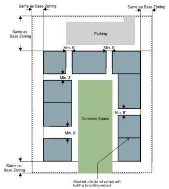
Figure 20.50.720(A)(1): Cottage Setbacks and Building to Building Placement
B. Parking.
1. Parking shall be clustered within a common parking area that is accessible but peripheral to the units.
2. Parking shall be located to minimize visual impact on the site while limiting the amount of hardscape devoted to vehicles. Parking shall be screened from public view and shall not visually dominate the site frontage.
3. The priority order of the location of parking access shall be as follows:
a. Parking shall be located in the rear of the development if accessed by an alley;
b. Parking shall be located on the side of the development if accessed by a private driveway, arterial or nonarterial street;
c. If accessing from the street and the site has multiple street frontages, the frontage with the lowest street classification shall be the primary access point;
d. The applicant may request a waiver from the Director with a demonstration that the parking area is not feasible and that parking shall be screened from public view.
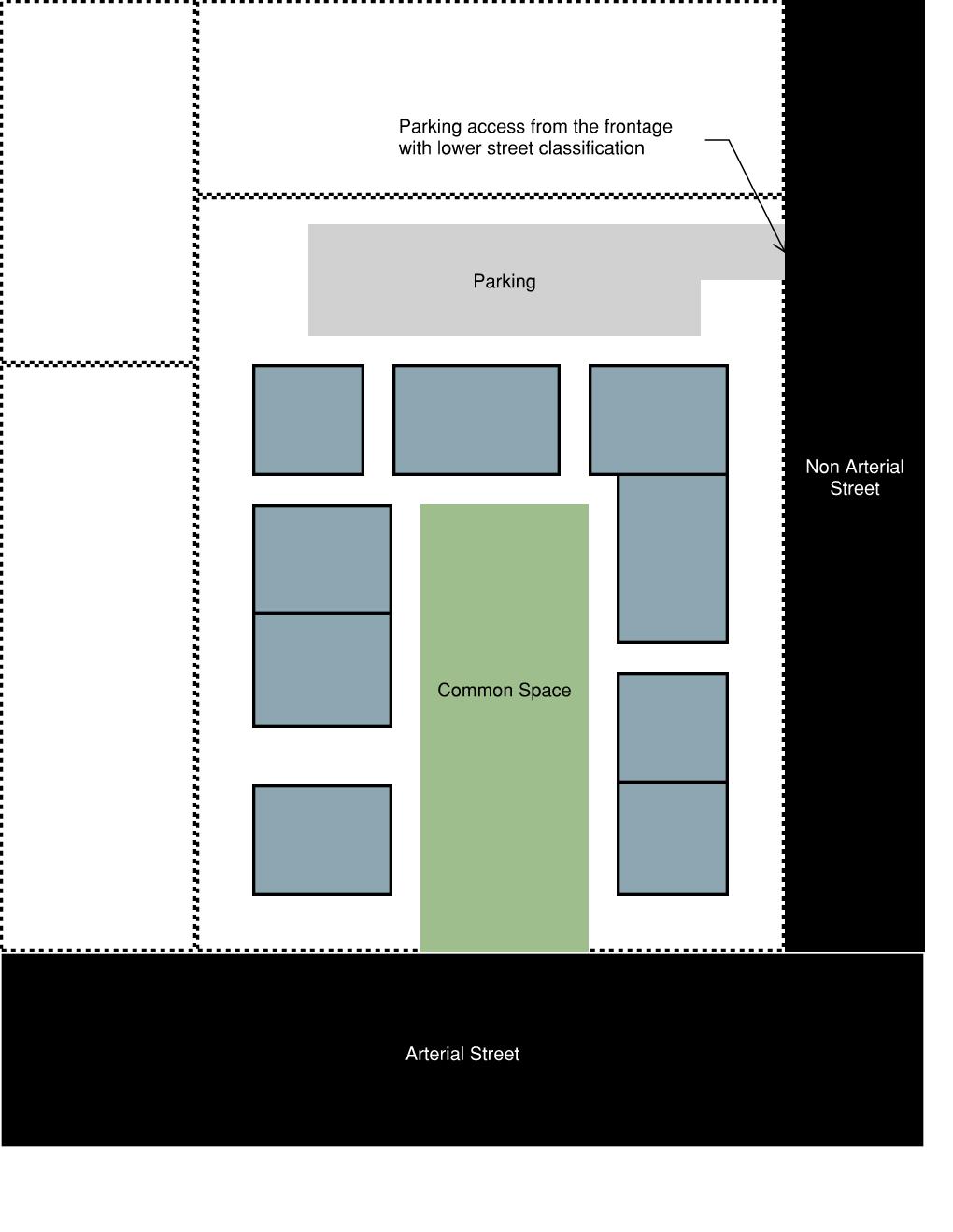
Figure 20.50.720(B)(3): Preferred Parking Configuration Through Rear Access Driveway
4. Garages. Parking provided in garages shall meet the following standards:
a. Garages shall meet location and parking access standards set forth in subsection B of this section.
b. Garage elevations visible from a public street shall be designed to minimize visual impact through the use of fencing, lattices, landscaping, or other screening methods.
c. Garages shall use materials and architectural design elements that are consistent with the architecture of the cottages.
d. Garages shall not be attached to cottages and shall be a minimum of eight feet from a cottage.
e. Up to four garages may be attached to one another.
5. Surface Parking. Parking outside of garages shall meet the following standards:
a. Parking shall be screened per SMC 20.50.470.
b. Internal landscaping for parking areas shall be consistent with SMC 20.50.500(A) and (C) through (E).
c. Required perimeter landscaping shall not count towards parking area landscaping requirements.
C. Site Configuration.
1. Cottage developments may have flexibility in how cottages are placed if a minimum of eight cottages are proposed. Applicants may provide multiple common open space areas to meet the requirements of subsection H of this section, Common Open Space. If multiple common open space areas are provided, cottages can be divided into smaller common-area oriented groups.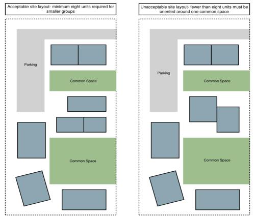
Figure 20.50.720(C): Flexible Site Configuration With Multiple Common Open Space Areas
D. Site Access and Circulation.
1. Vehicle access requirements are set forth in the engineering development manual and SMC 15.05.050, Fire Code.
2. Each cottage shall have a paved on-site pedestrian pathway, providing access to a public sidewalk, common open space, common parking areas, common buildings and common solid waste areas, if provided.
3. Pedestrian pathways shall be a minimum of four feet wide and shall be illuminated as provided in SMC 20.50.740, Outdoor Lighting Standards.
E. Storage Space and Staging Area for the Collection of Solid Waste.
1. Developments with nine or fewer cottages shall comply with one of the following options for providing solid waste storage and staging areas:
a. If the storage space is provided in a garage belonging to an individual cottage, the storage space shall be its own dedicated area and shall not conflict with space needed for required vehicle parking.
b. Staging areas for solid waste collection shall comply with one of the following:
i. Solid waste bins shall be placed in the amenity zone if there is adequate area and placement does not conflict with above-grade infrastructure or services, including, but not limited to, fire hydrants, electrical poles, mailboxes, and street trees; or
ii. Solid waste bins shall be placed within the front setback, provided the area needed to accommodate the bins does not preclude compliance with other codes and standards; or
iii. Solid waste bins shall be placed along one side of the access drive, provided placement does not interfere with vehicular access and circulation, and the City’s solid waste purveyor provides written confirmation it will service the location of the bins.
c. If the storage space and staging area are provided in a common indoor trash room or rooms or a common outdoor enclosure or enclosures, it shall comply with all the following:
i. Access to and maintenance of the trash room(s) or enclosure(s), and financial responsibility, shall be addressed in a covenants, conditions and restrictions document to be recorded prior to development permit issuance;
ii. The City’s solid waste purveyor provides written confirmation it will service the location of the trash room(s) or enclosure(s); and
iii. If the storage space is provided in an outdoor enclosure or enclosure(s), it shall be completely screened from pedestrian view from the public right(s)-of-way by a solid enclosure such as a fence or wall, or dense landscaping.
2. Developments with 10 or more cottages shall comply with one of the following options for providing solid waste storage space and a staging area:
a. If the storage space is provided in a garage belonging to an individual cottage, the storage space shall be its own dedicated area and shall not conflict with space needed for required vehicle parking.
b. Staging areas shall abut vehicle access drives, but shall not obstruct vehicle circulation, and shall comply with one of the following:
i. The vehicle access shall not dead-end, but provide a through connection to a public right-of-way; or
ii. The site shall contain a turnaround that meets the standard detail required by the Public Works Director.
c. If the storage space and staging area is provided in a common indoor trash room or room(s), or in a common outdoor enclosure or enclosure(s), it shall comply with the following:
i. Access to and maintenance of the trash room(s) or enclosure(s), and billing, shall be addressed in a covenants, conditions and restrictions document to be recorded prior to development permit issuance; and
ii. The City’s solid waste purveyor provides written confirmation it will service the location of the trash room(s) or enclosure(s); and
iii. If the storage space is provided in an outdoor enclosure or enclosure(s), it shall be completely screened.
F. Utility and Mechanical Equipment.
1. Mechanical and utility equipment shall be located and designed to minimize visibility by the public. Preferred locations are abutting alleys, access drives, within, atop, or under buildings, underground, or other locations away from the public right-of-way. Equipment shall not intrude into required common open space or pedestrian pathways.
G. Private Open Space.
1. Each cottage shall be provided private open space. Private open space shall be directly contiguous to and accessed from each cottage.
2. Dimensional Requirements.
a. Each cottage shall be provided with no less than 300 square feet of private open space.
b. No open space with a dimension less than six linear feet shall count towards private open space requirements.
c. Required porch areas may be counted as private open space.
d. Required perimeter landscaping shall not be counted as private open space.
3. Porches.
a. Each cottage shall have a covered front porch which equals no less than 10 percent of the total gross floor area of the cottage.
b. All required porches shall be attached to the cottage, provide access to the cottage, and have a minimum lineal dimension of six feet.
c. Porches shall be oriented toward the common open space, or right-of-way.
H. Common Open Space.
1. A cottage development shall provide a minimum of 250 square feet of common open space per cottage.
2. Common open space shall serve as a focal point for the development, be landscaped, and provide usable open space for recreation and community activities for the development.
a. Common open spaces may be comprised of lawns, gardens, plazas, trees, or similar features.
b. Common open spaces may include seating areas.
c. Covered but unenclosed permanent structures such as gazebos may count as both common open space and as a required amenity.
d. Common open space shall be designed and located to protect existing stands of trees. See SMC 20.50.760, Tree preservation incentives.
i. The dripline of on-site significant trees greater than 24 inches DBH can count as common open space area on a per-square-foot basis.
e. Common open space areas shall be a maximum of 60 percent lawn area. For the purposes of this subsection lawn area is an open space covered with soil and planted with grass which is cut regularly.
f. A minimum of 10 percent of the common open space area shall be dedicated as pollinator habitat.
i. If at least 20 percent of the required common open space is dedicated as pollinator habitat it may count as a required amenity.
3. Accessibility.
a. Common open space shall be located and made accessible to all residents of the cottage housing development.
b. Common open space shall be connected to other areas of the development through on-site pedestrian pathways.
4. Dimensional Requirements.
a. No space with any dimension less than 20 linear feet or an area of less than 500 square feet shall count towards common open space requirements, except that the drip line area of a significant tree greater than 24 inches DBH that is providing common open space is not subject to these standards.
b. Required perimeter landscaping shall not count towards common open space.
c. For developments with a minimum of eight cottages, common open space is permitted to be separated into smaller areas, subject to the following:
i. Total common open space and dimensional requirements of this subchapter are satisfied. A separate common area is permitted for every four cottages. There shall be a primary common open space that comprises a minimum of 60 percent of the total common open space area.
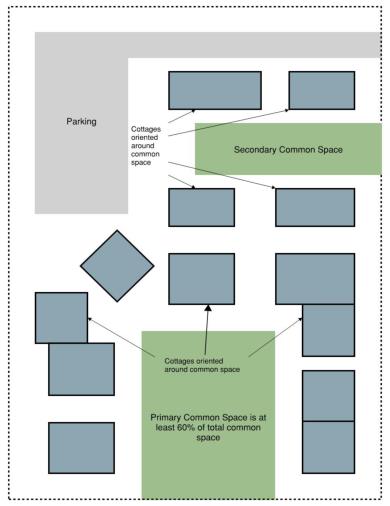
Figure 20.50.720(H)(4)(c): Cottage Open Space Sample Layout
5. Amenities. Amenities shall be provided within common open space. For the purposes of this subsection an amenity is defined as interactive social or recreational spaces and/or equipment. An amenity can either be outdoors or inside a community building.
a. A minimum of one amenity shall be provided for every four cottages.
b. At least one outdoor amenity must be provided in each development.
i. Outdoor amenities include, but are not limited to, gazebos, community gardens, landscape structures, permanently affixed tables and chairs or communal lounging areas, or a pollinator habitat that is at least 20 percent of the common open space.
ii. Outdoor amenities shall comply with lighting standards in SMC 20.50.740.
6. Community Buildings. Community buildings, clubhouses, or structures are optional and can be counted as a required amenity provided the following requirements are satisfied:
a. Community buildings shall be on site and permanently affixed.
b. Community buildings shall be consistent with the architectural design of the development.
c. Community buildings shall not exceed 1,000 square feet in gross floor area and 15 feet in height.
d. Enclosed community buildings may not be counted towards the area requirements for common open space.
I. Perimeter Landscaping.
1. As required by SMC 20.50.490, a perimeter landscaping buffer is required along the side and rear property lines.
2. Required perimeter landscaping shall not count towards private open space, common open space, or parking area landscaping requirements. (Ord. 984 § 1 (Exh. A), 2023).
20.50.730 Building design – Standards.
A. Building Orientation.
1. Cottage front facades shall face a common open space or a right-of-way.
2. Site layout shall ensure privacy between cottages. Cottage orientations, window locations, landscaping, and staggering cottages are examples of strategies that support privacy.
3. Cottages may be attached or detached. A maximum of two cottages may be attached to one another. When five or more cottages are in a development, detached cottages must comprise at least 49 percent of the total number of cottages per cottage housing development.
B. Cottage Size. When a development contains five or more cottages:
1. At least 60 percent of the gross floor area of a cottage shall be on the ground floor.
2. A minimum of 20 percent of cottages shall vary at least 250 square feet above or below the average gross square footage of cottages in the development.
3. A minimum of 20 percent of all cottages within a development shall not exceed 15 feet in height.
4. Cottages that exceed 15 feet in height shall have a pitched roofline. The roofline may not exceed the maximum height permitted and must be between a 12:6 and 12:12 pitch. Dormers must also meet this pitch requirement.
C. Cottage Variety.
1. Architectural techniques to create a variety of cottage designs are required. A development shall select a minimum of three techniques to diversify cottages, including but not limited to: windows, articulation, variation, trim, and varied rooflines. Other architectural features may be considered by the city if the design meets the purpose of this subchapter in SMC 20.50.700.
2. Cottages with identical architectural designs shall not be placed directly adjacent to one another and shall be separated by at least one other nonidentical cottage. Variation in materials or colors between adjacent cottages is required to create distinct cottages within a development. (Ord. 984 § 1 (Exh. A), 2023).
20.50.740 Outdoor lighting standards.
A. Light Trespass Standard. All light sources, such as a lamp or bulb, shall be shielded within a fixture, and fixtures shall be located, aimed or shielded to prevent direct light trespassing from the development to adjacent properties or directly up towards the sky.
B. On-site pedestrian pathways shall be illuminated with at least two foot-candles of light.
C. Cottage entries shall be illuminated with at least four foot-candles of light.
D. Prohibited Lighting. The following types of lighting are prohibited:
1. Outdoor floodlighting by floodlight projection above the horizontal plane;
2. Search lights, laser source lights, or any similar high intensity light; and
3. Any flashing, blinking, rotating or strobe light illumination device located on the exterior of a building or on the inside of a window which is visible beyond the boundaries of the lot.
Exemptions:
a. Lighting in swimming pools and other water features governed by Section 321 (Lighting) of the International Swimming Pool and Spa Code, or Chapter 246-260 WAC, as applicable.
b. Signs and sign lighting regulated by Chapter 20.50 SMC, Subchapter 8.
c. Holiday and event lighting (except for outdoor searchlights and strobes).
d. Lighting triggered by an automatic emergency or security alarm system. (Ord. 984 § 1 (Exh. A), 2023).
20.50.750 Fences and walls – Standards.
A. Front yard fences and walls located within the required minimum front yard setback shall be a maximum of three feet, six inches high and shall be no more than 60 percent opaque.
B. Side and Rear Yards. A six-foot-tall solid fence or wall is required along the side and rear property lines.
C. Private Open Space Fences. Fences delineating private open space are optional and shall be a maximum of three feet, six inches high.
D. Materials. Fences and walls shall be constructed of wood, wrought iron, brick, stone, or other high quality material. All chain link, electric, razor wire, and barbed wire fences, and other similar types of security fences are prohibited.
E. Height. The height of a fence located on a retaining wall shall be measured from the finished grade at the top of the wall to the top of the fence. The overall height of the fence located on the wall shall be a maximum of six feet. (Ord. 984 § 1 (Exh. A), 2023).
Subchapter 11.
Transfer of Development Rights Program (TDR)
20.50.800 Transfer of Development Rights Program (TDR).
A. Purpose. A Transfer of Development Rights (TDR) Program is established: (1) as an incentive for protecting farms, forests, rural lands, and environmentally critical areas while encouraging greater development potential within specified areas of Shoreline; and (2) as a potential way to obtain infrastructure financing.
B. Definitions.
“Baseline development potential” means the maximum development intensity allowed in receiving areas without the use of a TDR credit for additional development.
“County” means the county government of King County.
“Development bonus” means the additional development value that a project using TDR may gain beyond baseline development potential. Types of development bonus are specified in this subchapter and may include additional development intensity or flexibility in certain requirements.
“Development right” means the right of a property owner to build one residential unit on a sending area parcel. Development rights may be converted to TDR credits and sold to developers to gain development bonus in a receiving area.
“Exchange rates” specify how much development bonus a receiving area project may gain in return for the acquisition of one TDR certificate. Exchange rates are expressed as a ratio in terms of the quantity of development bonus per TDR certificate.
“Sending areas” are those lands prioritized by counties for conservation established by their respective countywide TDR programs.
“TDR” means transfer of development rights, a voluntary, market-based real estate tool that encourages growth in areas where it is desired while conserving those lands where growth is not desired. TDR is recognized and encouraged as an innovative land use technique under the Growth Management Act (RCW 36.70.090).
“TDR certificate” is the proof of ownership of development rights, taking the form of a recorded document issued by a county, showing the number of development rights the holder has acquired and may use in a receiving area project. A TDR certificate may represent multiple TDR credits.
“TDR credit” is a tradable commodity representing one development right from a county sending area as certified by a county.
“TDR Manager” means the City employee assigned by the Planning and Community Development Director to accomplish the duties specified as City responsibilities in this subchapter.
“TDR receiving areas” are those geographies within the City as established in this subchapter where TDR may be used to gain development bonus.
C. Applicability. The TDR Program applies to development in receiving areas and the administration of TDR transactions under this subchapter. This subchapter establishes requirements for applying TDR certificates to new construction in receiving areas and the extent of increased development allowed within them.
D. Location of Sending Areas. Sending areas under this program shall be within unincorporated counties, provided that such areas have been designated by the counties as agricultural or forest lands of long-term commercial significance or as rural lands that otherwise meet the sending area criteria as established in the counties’ respective TDR program rules and regulations.
E. Sending Area Development Limitations. The City will accept the transfer of development credits from eligible sending areas; provided, that the credits are transferred in accordance with the requirements of this subchapter.
1. To transfer development credits, the sending area must be encumbered by a conservation easement or other similar encumbrance approved by the county in which the sending area is located.
2. All conservation easements used to achieve development bonuses encumbering real property pursuant to this subchapter must be conveyed in a manner consistent with RCW 64.04.130. The grantee of the conservation easement must be the county or a third party with the express right to enforce the terms of the conservation easement.
F. Sending Area TDR Certification. For sending areas situated in unincorporated King County, the TDR certificate must be issued pursuant to King County Code 21A.37.070 or any amendment thereof.
For sending areas situated in unincorporated Snohomish County, the TDR certificate must be issued pursuant to Snohomish County Code 30.35A.050 or any amendment thereof.
For sending areas situated in unincorporated Pierce County, the TDR certificate must be issued pursuant to Pierce County Code 18G.10.110 or any amendment thereof.
G. Location of Receiving Areas. The City’s receiving areas for development credits under this subchapter are areas within the TDR receiving areas as shown below: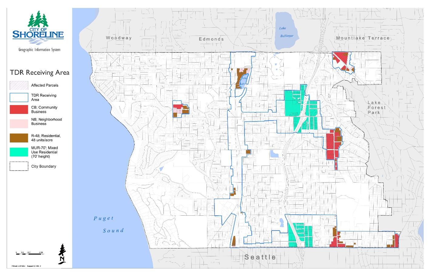
Within the TDR receiving areas shown on the map, the following zones are established as TDR receiving areas:
1. NB – Neighborhood Business (NB).
2. CB – Community Business (CB).
3. MUR-45’ – Mixed-Use Residential (45' height).
4. MUR-70' – Mixed-Use Residential (70' height).
5. R-48 – Residential, 48 units/acre.
H. Receiving Area Baselines and Exchange Ratios. In the receiving areas shown in subsection G of this section, bonus development shall be awarded as follows:
|
Zone |
Baseline Height |
Max Height |
Bonus |
Pierce |
King |
Sno Co. |
Type |
|---|---|---|---|---|---|---|---|
|
R-48 |
35' |
70' |
Height |
1 credit = 1,100 sq. ft. |
1 credit = 7,000 sq. ft. |
1 credit = 2,900 sq. ft. |
Farm |
|
1 credit = 2,900 sq. ft. |
1 credit = 3,100 sq. ft. |
1 credit = 2,900 sq. ft. |
Non-Farm |
||||
|
NB |
50' |
70' |
Height |
1 credit = 1,100 sq. ft. |
1 credit = 7,000 sq. ft. |
1 credit = 2,900 sq. ft. |
Farm |
|
1 credit = 2,900 sq. ft. |
1 credit = 3,100 sq. ft. |
1 credit = 2,900 sq. ft. |
Non-Farm |
||||
|
CB |
60' |
70' |
Height |
1 credit = 1,100 sq. ft. |
1 credit = 7,000 sq. ft. |
1 credit = 2,900 sq. ft. |
Farm |
|
1 credit = 2,900 sq. ft. |
1 credit = 3,100 sq. ft. |
1 credit = 2,900 sq. ft. |
Non-Farm |
||||
|
MUR-45' |
45' |
45' |
Parking Reduction |
1 credit = 0.48 spaces |
1 credit = 1.75 spaces |
1 credit = 0.87 spaces |
Farm |
|
1 credit = 0.87 spaces |
1 credit = 0.92 spaces |
1 credit = 0.87 spaces |
Non-Farm |
||||
|
MUR-70' |
70' |
70' |
Parking Reduction |
1 credit = 0.41 spaces |
1 credit = 1.25 spaces |
1 credit = 0.67 spaces |
Farm |
|
1 credit = 0.67 spaces |
1 credit = 0.7 spaces |
1 credit = 0.67 spaces |
Non-Farm |
||||
|
MUR-70' |
70' |
140' |
Height |
1 credit = 3,100 sq. ft. |
1 credit = 19,700 sq. ft. |
1 credit = 8,200 sq. ft. |
Farm |
|
1 credit = 8,200 sq. ft. |
1 credit = 8,900 sq. ft. |
1 credit = 8,200 sq. ft. |
Non-Farm |
I. Receiving Area Process.
1. Developers who intend to exceed baseline development potential in a TDR receiving area shall acknowledge in development-related application materials that they will be required to submit the prescribed number of TDR credits at the time the developer submits the building permit application. Preliminary application approval, where applicable, will indicate the estimated number of TDR credits required prior to final approval. Applicants are not required to own or control TDR credits at the time of submitting the application and TDR credits do not impact a project’s ability to vest in current regulations. Applicants shall submit the prescribed number of TDR credits prior to the City’s issuance of building permits.
a. Developer communicates intent to exceed baseline development potential and acknowledges need to furnish TDR credits in preapplication process.
b. Developer estimates the number of TDR credits needed as part of the building permit application based on exchange ratios established under subsection H of this section.
c. City confirms the exact number of TDR credits needed prior to final building permit approval. For calculation purposes, development bonus must translate to whole numbers of TDR credits. If the desired increment of development bonus would result in a fractional number of TDR credits, the project must round up to the next whole number of TDR credits.
d. Applicant submits prescribed number of TDR credits to City prior to issuance of building permit.
2. Developers may obtain TDR certificates directly from a sending area landowner, from TDR banks, or from any other intermediary provided the certificates are issued by and in accordance with the requirements of their respective county’s TDR program.
3. Final building permit certificate of occupancy shall not be granted until the TDR Manager has provided written documentation of compliance with TDR requirements. The serial numbers of all TDR credits shall be recorded on the building permit for all projects using TDR.
4. Following receipt of TDR certificates for a receiving area project, the City shall extinguish the certificates and return them to the county of their origin confirming that they have been applied to a receiving area project.
J. TDR Manager Responsibilities.
1. The county shall maintain a TDR registry documenting the ownership history of all TDR certificates by serial number from the time they are granted to the sending area owner to their retirement in a receiving area development. The City shall document all TDR credit use in construction projects within the City, extinguish those credits upon use in projects, and return them to the TDR program administrator in the county of their origin.
2. Once the first TDR transaction has been accomplished, the county shall provide an annual report to Washington State Department of Commerce detailing the following information:
a. Number of TDR transactions completed.
b. Number of TDR credits transferred into the City.
c. Total number of new residential units in the City.
d. Number of additional residential units allowed due to TDR credit transfers.
e. Amount of additional building height allowed due to TDR credit transfers.
f. Amount of parking spaces reduced due to TDR credit transfers.
g. Amount of revenues received from King County.
3. The City should check at least annually with each participating county whether the TDR ratio has changed. If the ratio has changed, the City should propose any amendments, based on recommendations from each county, needed to make this subchapter consistent with the current county/City TDR ratios.
4. Modification of Receiving Site Incentives. The City is authorized to revise the exchange rate table to address changing economic conditions. The exchange rate table, subsection H of this section, shall not be revised more than once in a calendar year. The City shall base revisions on the following criteria as analyzed by a qualified, third-party expert:
a. The expected marginal value of the development bonus;
b. The prevailing cost of per square foot commercial or residential development and pro forma analyses of typical project costs in receiving areas;
c. Changes in sending area TDR credit pricing as reported by counties;
d. The City’s progress towards meeting TDR placement targets, if any; and
e. Consistency with the conservation principles and purpose and intent of this chapter.
5. The modified exchange rate table shall be used for calculation of receiving area development bonus. Within 14 days of adopting a revised exchange rate table, the Director shall update publicly available program information.
6. If a developer or private property owner requests revisions to the exchange rate table, the burden of preparing the economic analysis shall be on the developer or private property owner and the analysis shall be performed by a qualified third-party expert jointly selected by the City and the requestor.
7. If changes in the market suggest that forms of development bonus different from or supplemental to those in the exchange rate table are appropriate to include in the program, the City may recommend such modifications to Council and incorporate alternative options in the third-party analysis and table revisions subject to Council approval. (Ord. 1009 § 1 (Exh. A), 2024).


