


Chapter 6 – Flooding
6.1 Existing Conditions
History of Flooding in Olympia
6.2 Impacts of Flooding
Property Damage and Public Safety
6.3 Regulatory Requirements
6.4 Challenges
Limitations of Low Impact Development
Climate Change and Sea Level Rise
Maps
Map 6.1 Extents of Inundation from One Foot of Sea Level Rise
Figures
Figure 6.1 Pipe Condition Rating Program Results
Figure 6.2 Extent of Major Fill Projects in Downtown Olympia
Tables
Table 6.1 Rainfall Recurrence Intervals, Probabilities of Occurrence and Amounts
One of the main “Why’s” determining the strategies recommended in the Plan for the next ten years (Chapter 10) is the continued challenge of flooding, both from seasonal storms and tidal influences.
Frequent and severe flooding in the mid- to late 20th century was the main impetus for creating the Storm and Surface Water Utility in 1986. Since then, development standards, improved infrastructure, and better infrastructure management have greatly reduced the frequency and extent of flooding, but challenges remain.
The Utility has the City’s primary responsibility for flood mitigation through several of the Core Services described in Chapter 9. These include:
• Reviewing and approving Drainage Control Plans and engineered stormwater facilities for public and private development (see Section 6.3).
• Monitoring incidents of flooding and proposing improvements.
• Tracking “hot spots” where plugged drains cause localized flooding.
• Inspecting and maintaining stormwater facilities.
• Responding to flooding emergencies.
• Planning and managing construction of flood prevention and control facilities.
This chapter reviews the causes and impacts of flooding, the Utility’s role in implementing drainage design standards for new development, and remaining challenges.
6.1 Existing Conditions
Urban development has covered the land with impervious surfaces, greatly increasing the runoff of stormwater and preventing it from soaking into the ground and flowing slowly into streams, wetlands, lakes, and marine waters. Without effective stormwater management, the result is flooding, along with other impacts on water quality and habitat.
Strain on the System
Initial efforts to manage stormwater in the early 20th century focused on rerouting stormwater flows to constructed systems of channels and pipes – all intended to solve localized stormwater issues. While effective in the short term, these systems many times did not account for the capacity of downstream conveyance systems or future buildout of the area. Urbanization that came without effective methods of controlling peak stormwater flows (typically development before 1990) frequently pushed the downstream conveyance system beyond capacity or changed existing drainage patterns completely. Increased flows in City-maintained pipes and ditches overloaded undersized or poorly designed systems.
Approximately 330 acres of the City – mostly located downtown and in the South Capitol Neighborhood – are served by combined sewer conveyance pipes. These pipes drain wastewater from homes and businesses, while also draining surface streets of stormwater. All flows from these portions of the system flow to the LOTT Clean Water Alliance Budd Inlet Treatment Plant. While instances of combined sewer overflow (CSO) are extremely rare in Olympia, any increase in stormwater to these combined systems can be cause for concern. For more information about the combined sewer network and the dedicated stormwater conveyance system, see Chapter 4.
Causes of Flooding
Primary causes of flooding are:
• Runoff from Impervious Surfaces. A significant portion of rainfall in forested watersheds is absorbed into soils (infiltration), stored as groundwater, and slowly discharged to streams. As watersheds are urbanized, vegetation is replaced by impervious surfaces, reducing the area where infiltration to ground water can occur. Simply put, in a developed watershed, much more water arrives into a stream much more quickly, resulting in an increased likelihood of more frequent and more severe flooding.
• Deteriorating or Inadequate Public and Private Conveyance Systems. In an urban environment, runoff must be collected in extensive drainage systems that combine curbs, storm drains, sewer pipes, and ditches to carry stormwater to streams. Most of the stormwater infrastructure in Olympia was constructed prior to 1990, before there were well-established storm drainage design regulations. It is aging, often undersized, and lacking flow control facilities.
• Inadequate Maintenance of Conveyance Systems and Inlets. Public and private stormwater infrastructure requires regular maintenance to properly function. Sediment must be removed from storm drains and sewer pipes to maintain capacity. Leaves, vegetation and debris must be removed from storm drain grates and pipe ends to prevent clogging. Operations staff removes sediment from all storm drains at least every two years (arterial roadways are cleaned annually). Operation staff has established routes (“hot spots”) for clearing troublesome storm drain grates and pipe ends prior to and during major storms. This is particularly important during intense late summer storms and early fall storms when leaves are falling from the trees.
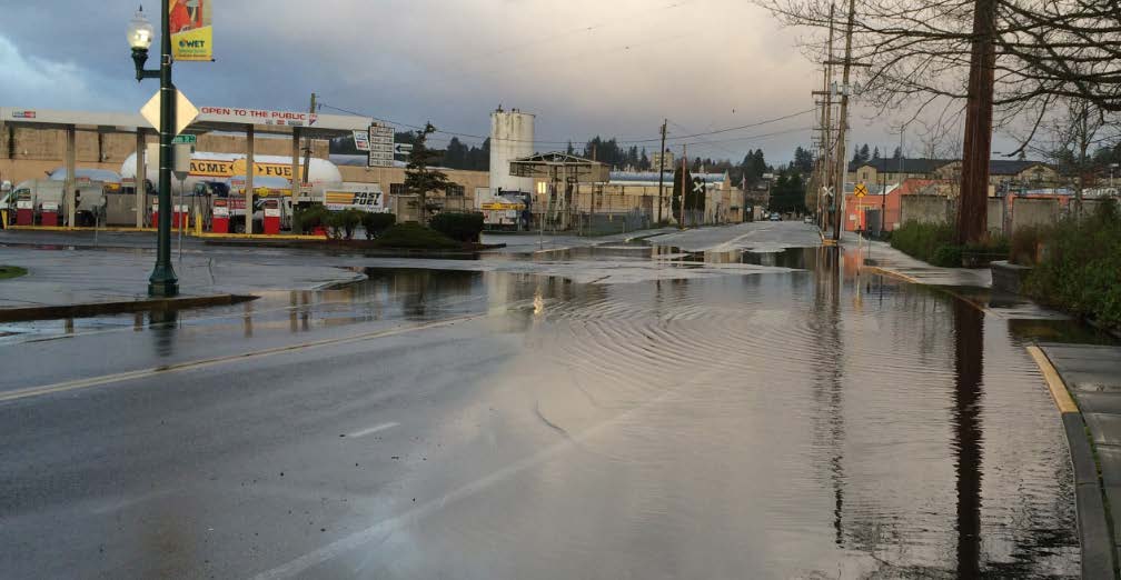
• Tidal Influence and Sea Level Rise. During high tides, marine water flows backward up stormwater conveyances, which can cause flooding in low-lying downtown streets and parking lots. These conditions typically resolve within hours as tides recede. As sea level rises, installation and maintenance of tide gates will help reduce this type of flooding.
• Areas of High Groundwater. Much of Olympia is underlain by shallow groundwater. In years when groundwater is high, flooding can be observed in closed depressions and seepage can increase or appear on sloped properties.
History of Flooding in Olympia
Urban development has steadily increased the volume and rate of stormwater runoff, and has resulted in flooding and damage to streams and wetlands where none had existed previously. Current stormwater regulations were created to prevent flooding and erosion, but the majority of stormwater infrastructure pre-dates these regulations.
Since the creation of the Storm and Surface Water Utility, the magnitude and frequency of flooding in Olympia has decreased significantly. Most major flooding issues have been corrected and localized flooding has been reduced to sporadic incidents. Roadway closures and property damage reports now only occur in extreme storm events. Nuisance flooding still occurs, but the extent is limited to ponding that generally resolves within hours or a day without incurring structural damage. Claims against the City for flooding incidences have been significantly reduced.
Major flood infrastructure projects and actions to reduce flooding have included:
• New or improved ponds to control the release of flows, thus reducing flooding and erosion. Key pond facilities include Black Lake Meadows, Yauger Park, Taylor Wetlands, Cooper Point Auto Mall and Mud Bay Road.
• New or improved stormwater conveyances to provide capacity and reduce flooding. Key projects have included daylighting Indian Creek and construction of culverts to reduce flooding at Union Avenue and Plum Street, major piping system upgrades to reduce flooding at Cooper Point Road and Black Lake Boulevard, a new pipe system to convey runoff from Crosby Boulevard and Courthouse Hill to Capitol Lake to eliminate closure of Deschutes Parkway, a new culvert under Black Lake Boulevard, a new culvert under RW Johnson Boulevard, and new piping in Van Epps Street to prevent flooding of Royal Gardens.
• Several ponds have been built with roadway reconstruction projects resulting in retrofits that brought legacy roadways up to current standards. Key projects of this type have included 18th Avenue, Division Street, Harrison Avenue, Sleater-Kinney Avenue, Fones Road roundabout, Log Cabin Road roundabout, 22nd Avenue roundabout, and Morse-Merryman Road roundabout.
• Additional retrofits have occurred with redeveloped properties that have made substantial improvements (cumulatively greater than 50% of the property value).
• Staff has identified and mapped areas requiring increased attention (“hot spots”) and routes for inspecting them during storm events.
• A new valve and bypass pumping system installed at 7th Avenue and Water Street has significantly reduced flooding in the vicinity associated with high tides and/or high Deschutes River flows.
• Staff has worked with the Washington State Department of Enterprise Services to better understand, prepare for and coordinate emergency response for Capitol Lake flooding.
Extreme storm events, such as the multi-day storm in December 2007, still cause flood conditions in the Cooper Point Road/Black Lake Boulevard intersection, Chambers Basin, Ken Lake, and Capitol Lake areas. The 2007 event exceeded the “100-year storm,” an event defined as having a 1% probability of occurrence during any given year.
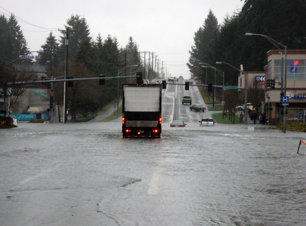
Black Lake Boulevard at Cooper Point Road, December 2007
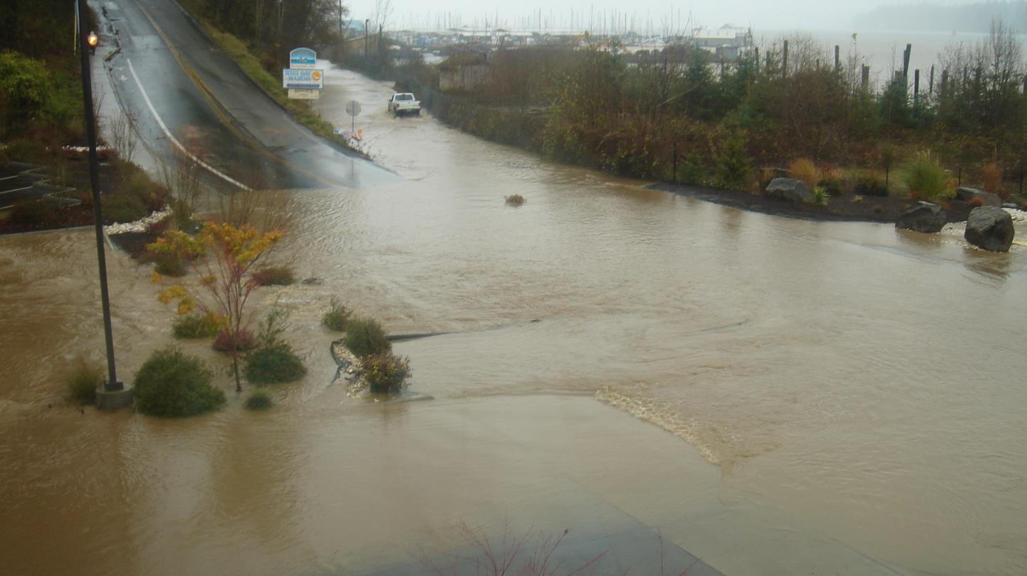
Schneider Creek Overtops West Bay Drive, December 2007
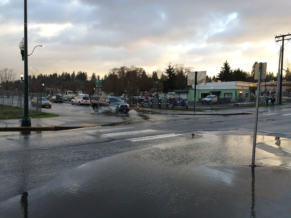
Flooding at State Avenue and Chestnut Street during High tide Following a Storm, March 2016.
6.2 Impacts of Flooding
The major impacts of flooding are property damage and risk to public safety, habitat degradation, and strain on infrastructure.
Property Damage and Public Safety
Early stormwater management focused on protecting public safety and health and preventing flood damage to property. The effects of flooding are most commonly measured by damage to property and threat to public health and safety. Stormwater runoff that is allowed to run off developed properties unmitigated can flood properties downstream. Typical flooding problems include localized surface ponding and damage to buildings and structures. Larger scale flooding has the potential to close entire streets and limit access to parts of the City. A primary concern with localized ponding of stormwater is along streets where water is allowed to pool in a vehicle lane and inhibits safe traffic movements. Also, when streets are flooded full width during extreme events, emergency service access can be limited.
Habitat Degradation
In recent decades, environmental impacts of increased stormwater runoff have become a priority. Poorly managed seasonally high and low stream flows cause erosion, channel widening, streambed alteration, loss of streamside habitat, degradation of water quality, and barriers to fish migration and spawning. Rapidly changing water levels and increased nutrients alter the natural character and function of remaining wetlands. For details on the impact of urbanization on natural systems, see Chapter 4 Section 4.1. Chapter 8 discusses the existing condition of the City’s streams, wetlands, and other aquatic habitats.
6.3 Regulatory Requirements
The most important tool the Utility has to manage flooding is the implementation and enforcement of State and local drainage regulations. All new development and redevelopment projects within the City are subject to the requirements of the Drainage Design and Erosion Control Manual (DDECM) and Engineering Design and Development Standards (EDDS). While development that occurred before 1980 made little attempt to control the volume, rate, and timing of stormwater runoff, current codes and standards provide specific requirements for managing increased stormwater runoff from impervious surfaces in the City.
Pursuant to the federal Clean Water Act, the Washington State Department of Ecology (Ecology) manages the National Pollutant Discharge Elimination System (NPDES) in Washington through a permit issued to anyone discharging stormwater into waters of the state. Under Olympia’s Phase II Municipal Stormwater Permit (the Permit) the City must adopt stormwater management regulations functionally equivalent to the 2012 Stormwater Management Manual for Western Washington with 2014 amendments. A key component for compliance with the Permit is the application of the thresholds and minimum requirements for stormwater management on new and redevelopment projects as identified in Appendix 1 of the Permit.
To comply with the Permit, the Olympia City Council adopted the new Drainage Design and Erosion Control Manual (DDECM) by passing Ordinance 7027. The new DDECM became effective on December 1, 2016; it complies with the Permit requirement to provide a manual equivalent to the Ecology stormwater design manual. Notable changes and updates with the new DDECM are:
• Introduction of low impact development requirements for managing stormwater runoff.
• Revisions to the thresholds and requirements for retrofitting redevelopment sites for treatment and flow control.
• Significant revisions to the long-term inspection and maintenance of stormwater management sites (i.e., designated areas containing stormwater facilities).
Key components of the current DDECM and EDDS are described in this section.
Design Storms
Frequent references are made in the DDECM and EDDS to specific storm events as “25-year storm” or the “100-year flood”. Many times these terms are used without proper understanding of the implication. While rare, it is possible for 100-year floods to occur two years in a row or even twice in one year.
Design storms are characterized by exceedance probability, or the percent chance that a storm or flood of a certain magnitude can occur in any given year. The magnitude of storms with these recurrence intervals in the City are defined within the DDECM.
Historical Precipitation Data
The precipitation amounts for these storms are determined based on historic precipitation records, and generally are limited in practical application for system design. Precipitation records in Olympia date back to 1955.
Source: Developed from the 1973 National Oceanic and Atmospheric Administration Atlas 2, Precipitation-Frequency Atlas of the Western United States, Volume IX-Washington.
As required by the 2016 DDECM, all flow control facilities – such as detention ponds, infiltration ponds, underground storage vaults or trenches – must be designed using actual precipitation data collected over the last 60 years in Thurston County. The Utility maintains an interlocal agreement with Thurston County for collection of the rainfall data from various locations throughout the County.
Watershed Precipitation Data
Analysis of this historical data typically shows the highest precipitation to be in the western watersheds with diminishing precipitation in eastern watersheds. The obvious effect of differing rainfall trends across the City is the size and design of stormwater facilities, especially those for flow control. However, this recorded data set provides a significant advantage over synthetic design storms. Stormwater systems are now designed with accurate storm data that reflects not only peak rainfall intensities, duration of storm flows, which is an important consideration to protect streams and other aquatic habitats. The effect of very high, sustained flows in streams has been cited as a cause for stream bed scouring and destruction of habitat. Flow control design standards for different system elements are discussed in more detail below.
Modeling Challenge: Predicting Effects of Climate Change
Predicting the precipitation effects of climate change poses a challenge for hydrologic modeling for stormwater system design. Utility staff is engaged in regional discussions and workshops discussing the influence of climate change and suitable methods for incorporating those predictions into stormwater facility design. As confidence in climate change modeling increases, the Utility will consider requiring the inflation of precipitation data in anticipation of increased intensity storm events.
Collection and Conveyance
A well-designed stormwater conveyance system is crucial to effective stormwater management and flood prevention. Conveyance systems include a combination of pipes, ditches, swales (e.g., flat bottom ditches that provide water quality treatment), storm drain inlets, catch basins, and manholes. (See Chapter 4, Section 4.2 for definitions.) When any new conveyance system is designed or older systems are retrofitted, the standards described below are applied.
• All newly constructed conveyance systems are required to accept and pass a minimum of the 25-year, 24-hour peak storm flow. A storm event with this magnitude has a 4% chance of occurring during any given year. This level of design has been accepted as civil engineering standard practice for decades, and is not exclusive to Olympia. Conveyance in key arterial roadways and areas susceptible to structural flooding are required to be designed to capture and pass the 100-year, 24-hour peak storm (1% annual).
• The City’s Engineering Design and Development Standards (EDDS), include requirements for pipe materials, minimum sizes, and stormwater structure type. Where not explicitly mentioned in the EDDS, stormwater components are required to meet Washington State Department of Transportation standard specifications and plans.
• A portion of the City’s stormwater runoff is collected by combined stormwater and wastewater pipes. By code, new stormwater runoff from new development and redevelopment cannot be added to the combined sewer. As described in Olympia Municipal Code section 13.20.050 – Prohibited Discharge Standards, new connections to the combined system and increases in stormwater flows are prohibited. The Utility attempts to separate the two system flows where possible, especially if capacity is limited, thereby reducing combined sewer overflows and the influent load on the LOTT wastewater treatment plant.
Detention and Flow Control
Flow control facilities are designed to mitigate the excess surface runoff resulting from a development project. The excess stormwater must be stored and then released at the rate and duration that existed prior to development in order to protect downstream properties and resources. The requirement is to mitigate storm flows equal to half of the 2-year flow up to the full 50-year storm.
Detention ponds, infiltration or retention ponds, underground vaults or infiltration galleries are all classified as flow control facilities and are designed to completely drain between design storms. Some, but not all, facilities in this category have a combined water quality treatment function. Flow control facilities, as well as wetponds and other runoff treatment practices, are defined in Chapter 4.
Routine operation and maintenance of the City-owned stormwater management sites and ponds are discussed in Chapter 9. Structural maintenance and rehabilitation and vegetation management is done by Utility staff on City-owned facilities; the same requirements apply to privately owned flow control facilities. Most properties developed after approximately 1992 have maintenance agreements binding the owners to perform maintenance.
Low Impact Development
Ecology included provisions in the 2013-2018 Western Washington Phase II Municipal Stormwater Permit (Permit) requiring the City to revise its codes and standards to make low impact development the “preferred and commonly-used approach to site development.” Passed by City Council on July 13, 2016 and made effective December 1, 2016, the low impact development code changes comply with the Permit. Likewise, the City’s 2016 Drainage Design and Erosion Control Manual requires Low Impact Development techniques for new development when feasible.
Definition of LID
Low impact development (LID) is an approach to land development that seeks to mimic the natural hydrologic processes of a site and manage rainwater as close to where it falls as possible. Implementation of LID principles and practices manages stormwater to reduce the impact of built areas and promote the natural movement of water within an ecosystem. LID employs principles such as preserving and re-creating natural landscape features, preserving native vegetation, and minimizing impervious surfaces to create functional and appealing site drainage that treats stormwater as a resource rather than a waste product. The primary goal of LID is to reduce surface runoff, thereby reducing common problems associated with urbanization such as flooding and pollution of receiving waters. While some LID approaches may actually provide some level of pollutant removal, this is secondary to the reduction or elimination of surface runoff from a project site.
Examples of Low Impact Development Techniques
Low impact development techniques include various structural best management practices (BMPs) such as permeable pavements, green roofs, bioretention and rain gardens, as well as site development principles like reducing impervious surface coverage and retaining native vegetation. Any combination of these BMPs or practices can be employed on a project to achieve the objective of minimizing the effects of urban stormwater runoff.
A Bioretention Cell Surrounded by Permeable Pavement, Yauger Park, 2016
Implementing LID Codes and Standards
Within the context of fostering urban land use, the City has always sought to promote environmentally sensitive development. Over the years, the City’s zoning code and development standards have been updated to increasingly incorporate low impact development-friendly regulations. For example, Olympia reduced street lane widths in 2006 to some of the narrowest in the state. The City has long required single-family residential development to add soil amendment in disturbed, landscaped areas, as well as requiring full infiltration of roof runoff from downspouts. In 2000, the City adopted a unique zoning district and associated set of mandatory LID regulations within the highly sensitive Green Cove Creek watershed. The changes were intended to prevent further damage to aquatic habitat resulting from urban development. A comprehensive set of policy revisions covering development density, impervious surface coverage, lot size, open space/tree retention, street design, block sizes, parking, sidewalks, and stormwater management requirements are included in Chapter 9 of the Engineering Design and Development Standards.
Implementing Structural LID Techniques
The Public Works Department started implementing structural LID techniques more than 15 years ago. For example in 1999, City Council authorized the Utility to pursue the use of permeable pavements. One of the City’s first LID projects and the most commonly utilized installation since then has been pervious concrete sidewalks. Currently, more than five miles of pervious concrete or pervious asphalt sidewalk are scattered throughout the City.
With adoption of the 2016 Drainage Design and Erosion Control Manual, LID techniques will be used in nearly all site development and redevelopment and is expected to increase greatly in the in the next decade.
6.4 Challenges
Despite the progress made in the past several decades in reducing the frequency and severity of flooding, several major challenges remain:
Legacy Development
Most stormwater infrastructure in Olympia is a legacy of development constructed prior to 1980 without the rigorous storm drainage design regulations imposed since then. Older infrastructure often lacks the capacity to handle increased runoff resulting from growth and lacks flow control facilities to prevent downstream flooding. The Utility has corrected most of the worst problems, but many smaller issues persist. The worst remaining problems are on Black Lake Boulevard south of Cooper Point Road, the Lakemoor subdivision around Ken Lake, and along Division Street south of Conger Avenue. As roadways are reconstructed and properties are redeveloped, existing onsite and in some cases downstream infrastructure are being retrofitted to meet current regulations.
Asset Management
The Utility will continue to develop its asset management program, described in Chapter 9. Significant staff effort has been dedicated to improving the Utility’s understanding of the stormwater infrastructure. It is estimated that over 95% of the public infrastructure has been inventoried and mapped, and mapping of private infrastructure is extended daily.
The Utility began a condition rating program in 2011, using robotic cameras to televise the condition of stormwater pipes. Structural and operational defects are documented and rated using industry standardized methods. To date, the Utility has inspected 62 percent of the public pipe system. Figure 6.1 depicts the results.
The Utility has found most of the pipe system to be in good condition and repairs are currently manageable through spot repairs by Operations staff and current capital funding. Because the Utility prioritized inspection of older and larger pipes first, recent inspections are finding fewer defects requiring attention.
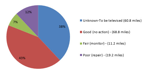
View Figure 6.1 Pipe Condition Rating Program Results
Limitations of Low Impact Development
While the advent of LID stormwater management provides additional tools for minimizing runoff, the methodology will have challenges, particularly education of designers and long-term maintenance.
Design
Although LID has been around for decades, it was only made a requirement for site design in December 2016 with adoption of the new Drainage Design and Erosion Control Manual (DDECM). Despite public outreach by the City and Ecology, most designers are not very familiar with the new regulations. LID stormwater best management practices used on a site are aimed at mitigating storms that are smaller and more frequent than a six-month storm (less than 1.5 inches of rainfall in 24-hours). In most cases LID will result in an increased number of smaller, decentralized stormwater facilities. In some cases, depending on soil conditions, LID may either replace or reduce the size of centralized pond facilities.
Maintenance
As opposed to centralized stormwater ponds where there is a single facility for an entire development, LID facilities are designed to be smaller, more numerous and effectively spread out over the development area to increase infiltration of rainwater over a larger area. The number of these facilities and the intensive maintenance regimen required is expected to make LID facilities more complex to manage than past stormwater facility designs. Additionally, with adoption of LID, the Utility agreed to perform maintenance of bioretention facilities permitted within the right-of-way. An evaluation of new roadway construction concluded that maintenance of new bioretention facilities within the right-of-way could require up to one half of a new FTE staff each year.
Climate Change and Sea Level Rise
Climate change has the potential to significantly impact stormwater management in Olympia primarily because of expected changes in precipitation timing and quantity, and sea level rise.
Changes in Precipitation
Although annual precipitation is not expected to change significantly, summer precipitation is projected to decrease by up to 10 percent and winter precipitation is projected to increase by up to 12 percent by the 2080s. Additionally, the maximum 24-hour precipitation event is expected to increase by up to 27% by 2080 and by even more in the upper Deschutes River basin.
Older stormwater infrastructure, the network of ponds and pipes that capture and channel runoff from streets and other impervious surfaces, will be most vulnerable to overflows associated with more frequent and intense storm events. As climate modeling improves, the Utility will consider requiring the use of inflated precipitation data for the design of flow control facilities.
Sea Level Rise
Sea level rise poses even greater challenges for stormwater management. Sea level rise is caused primarily by two factors related to global warming: the added water from melting land ice and the expansion of sea water as it warms. Sea levels are rising and the rate of sea level rise is expected to accelerate. The National Research Council’s Sea-Level Rise for the Coasts of California, Oregon, and Washington: Past, Present, and Future, published in 2012, estimated that sea levels will rise 20 to 55 inches by the year 2100.
Between 1893 and 2007, 15 dredge and fill projects added 434 acres and 1.9 miles of shoreline to downtown Olympia, including most of the Port of Olympia peninsula (TRPC 2008) (see Map 6.1). Not surprisingly, the filled areas are the most vulnerable to sea level rise. Map 6.1 depicts the Downtown Olympia Historic District and the extent of Olympia’s shoreline at various dates, and shows the expected extent of inundation during a 100-year tide event with one foot of sea level rise which could happen by 2038.
Given Olympia’s location near sea level, protecting the land and conveying water from the land surface to marine waters via piped systems will become more difficult as sea level rises. Higher sea levels will result in less hydraulic pressure to drive stormwater out of pipes. During high tides, marine water flows back up (backflow) into conveyance piping, in some cases causing flooding inland. In most cases, backflow flooding can be prevented by installing tide gates. However, eventually sea levels will rise to elevations that will require reconfiguring the storm drainage system and installing pump stations to get stormwater out of low-lying areas.
Additionally, stormwater from much of the low-lying areas of downtown are conveyed to the LOTT Clean Water Alliance Budd Inlet treatment plant via the combined sewer system. The combined sewer system will need to be reconfigured or separated to prevent inundating the treatment plant with marine water.
To date, with modest investments and no clearly assigned staff time, the Utility has taken the lead on studying sea level rise and developing response plans for the City. Moving forward, the scope of the work and scale of investments necessary to address sea level rise will require a separate interdepartmental program and funding mechanisms.
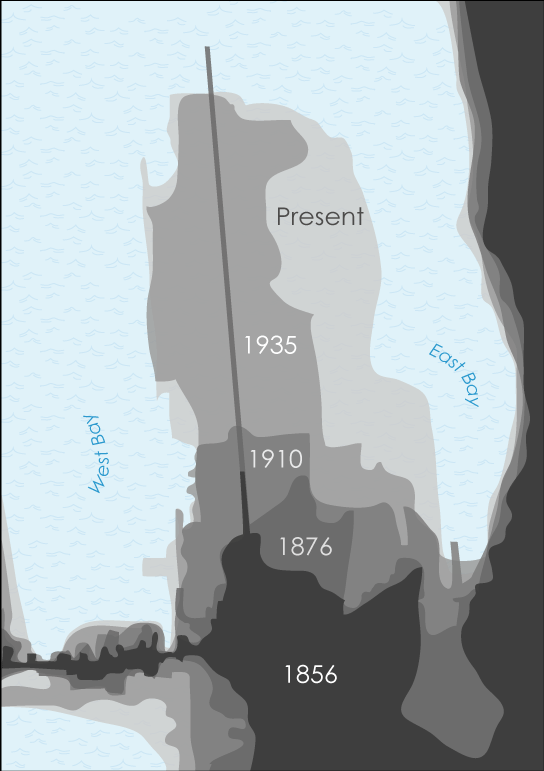
View Figure 6.2 Extent of Major Fill Projects in Downtown Olympia
Source: Sea-Level Rise: Re-imagining the Urban Edge, a thesis by Brenda Lorene Snyder, [2010]
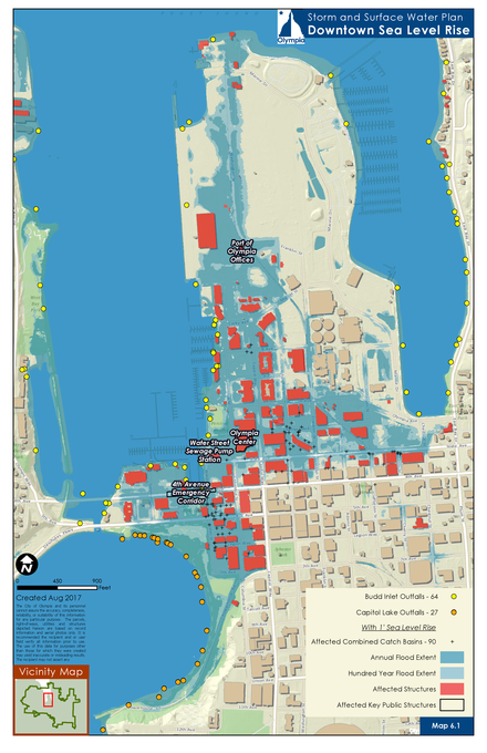
View Map 6.1 Extents of Inundation from One Foot of Sea Level Rise
Street Flooding Due to Tidal Backflow. Thurston Avenue at Adams Street, March 2016
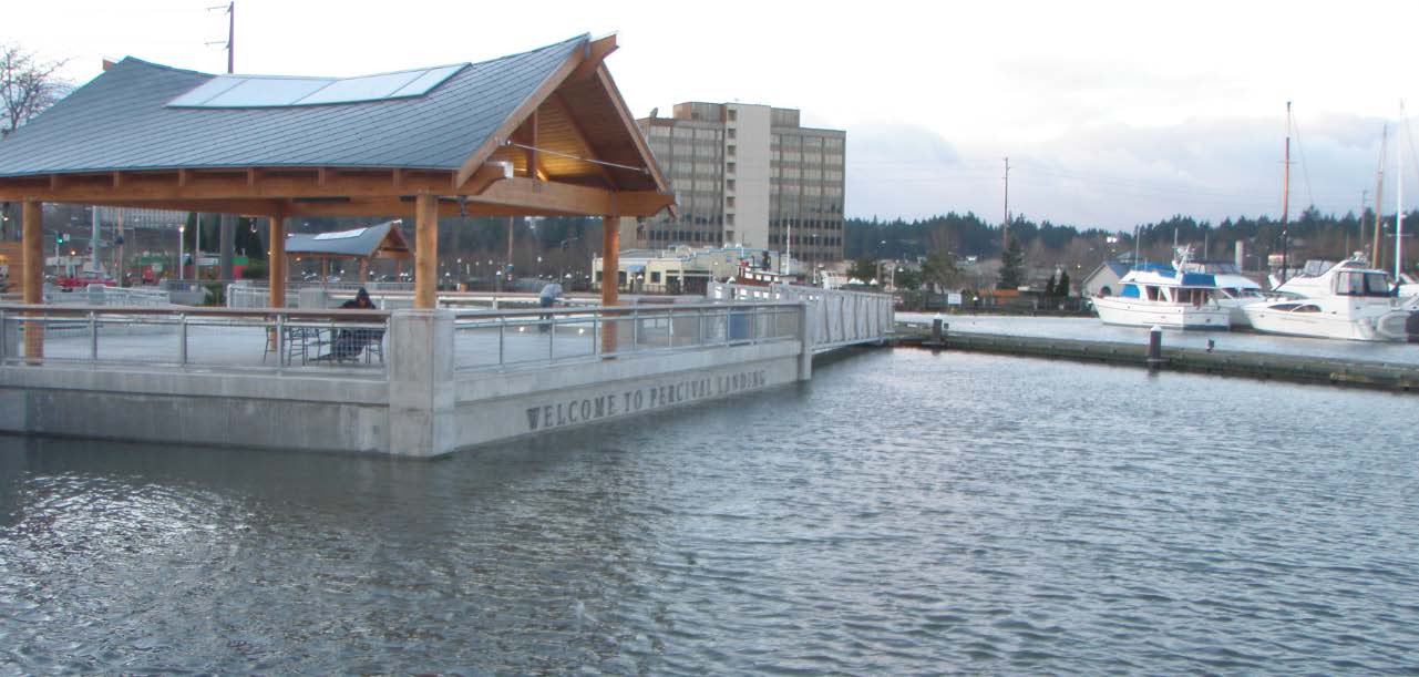
Percival Landing at High Tide, 2012