


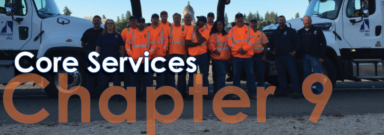
Chapter 9 – Core Services
9.1 Overview
9.2 Long-Range Planning
Water Quality Coordination (NPDES/TMDL)
9.3 Asset Management
Public Infrastructure Management
Private Infrastructure Management
Water Quality Monitoring and Evaluation
Habitat Monitoring and Evaluation
9.4 Technical Review and Support
Internal/External Technical Support
Stormwater Operations Problem Solving Team (STOPS)
9.5 Flood Prevention
Stormwater Facility Maintenance
9.6. Emergency Response
9.7 Pollution Prevention
Illicit Discharge Investigation
Stormwater Facility Inspection and Maintenance
9.8 Habitat Management
9.9 Capital Improvements Program
Flooding: Reducing the Frequency and Severity of Flooding
Water Quality: Pollution Prevention and Treatment
Aquatic Habitat: Protection, Enhancement, Restoration
9.10 Utility Administration and Support Services
Figures
Figure 9.1 Core Services Staffing Allocation
The Storm and Surface Water Utility staff is tasked with the stewardship of the Utility’s built and natural environment, with the primary responsibility of reducing the frequency and severity of flooding; improving water quality; and protecting, enhancing, and restoring aquatic habitat. Because of the broad nature of their work, some staff work from the maintenance center, some from City Hall, and some activities are performed by conservation crews throughout the City, the Urban Growth Area and beyond. This chapter describes the core services provided by the Utility. Proposed new and expanded services are described in Chapter 10.
9.1 Overview
In response to new demands on the Utility and organizational changes, the original core services defined in the 2003 Storm and Surface Water Plan have been revised. The nine Utility core services currently are:
• Long-Range Planning
• Asset Management
• Technical Review and Support
• Flood Prevention
• Emergency Response
• Pollution Prevention
• Habitat Management
• Capital Improvements Program
• Utility Administration and Support Service
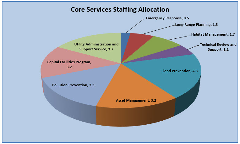
View Figure 9.1 Core Services Staffing Allocation
9.2 Long-Range Planning
The Utility currently dedicates approximately 1.48 FTE to Long Range Planning.
The Long-Range Planning core service is comprised of five primary programs: Storm and Surface Water Plan, Citywide Planning, Water Quality Coordination, Habitat Coordination, and Standard Operating Procedures. These programs are described in the following sections.
Potential changes to these programs, based on strategies to improve the Utility’s ability to achieve its goals, are discussed in Chapter 10.
Storm and Surface Water Plan
The Storm and Surface Water Plan provides policy, program, and financial guidance to the Utility in planning, managing, operating, maintaining, and improving the built and natural infrastructure. The planning process used to develop an updated Plan brings together staff from throughout the Utility, with input and feedback from the public. The Plan was last updated in 2003, with minor revisions in 2010. See Chapter 1 for more on the planning process.
Citywide Planning
Storm and Surface Water planning staff participates in many citywide planning efforts, including revisions to the Comprehensive Plan and Shoreline Management Plan and county-wide efforts such as revisions to the Urban Growth Area and associated policies. A specific work effort is devoted to the implications of expected sea level rise and tidal flooding in downtown that occurs during extreme high tides. See Chapter 6 for more on sea level rise.
Utility staff also participates in updating the Olympia Municipal Code to ensure stormwater regulations, shoreline master program, and critical area ordinance effectively protect aquatic habitat by remaining consistent with the Storm and Surface Water Plan and any new state or federal stormwater regulations. All new development and redevelopment projects within the City of Olympia are subject to the requirements of the Drainage Design and Erosion Control Manual (DDECM) and the Engineering Design and Development Standards. See Section 9.4 for the Utility’s role in review and approval of permits for new and redevelopment projects.
Water Quality Coordination (NPDES/TMDL)
Utility staff is responsible for coordinating the City’s compliance with its National Pollution Discharge Elimination System (NPDES) permit and Total Maximum Daily Load (TMDL) requirements.
Coordination of the NPDES permit includes monitoring program development requirements; annually updating the City’s Stormwater Management Program (SWMP); coordinating ongoing training requirements and needs; and ensuring that procedures and protocols for specific programs (i.e., Illicit Discharge Detection and Elimination, Education and Outreach, Operations and Maintenance, and construction) are developed and implemented.
TMDL coordination includes participating in the Deschutes TMDL Advisory Group (DAG), coordinating the City’s response to TMDL actions, monitoring compliance with conditions related to Henderson Inlet TMDL, and coordinating future compliance requirements for the Deschutes and Budd Inlet TMDLs.
See Chapter 7 for more on these permits.
Habitat Coordination
Collaborating with internal and external partners is critical to effective efforts to restore and enhance aquatic habitat and adapt to climate change. For example, the Utility participates in regional work groups like the Alliance for a Healthy South Sound and the WRIA 13 Salmon Recovery process.
Key habitat-related long-range planning tasks are: assessing priorities for restoring and enhancing habitat; assessing potential acquisition and other capital projects; integrating programs among ownership and habitat types; overseeing assessment and monitoring of habitat quality and quantity; planning restoration projects; and targeting outreach programs to make the most efficient use of Utility resources.
Other tasks include overseeing the City’s noxious weed control efforts, assisting with other City habitat-related plans and studies; and tracking habitat related code updates.
See Chapter 8 for more detail regarding habitat coordination.
Standard Operating Procedures
The Utility is developing Standard Operating Procedures (SOPs) to enable Operations and Maintenance (O&M) staff to perform their tasks properly and safely. These SOPs will be updated and then reviewed annually for necessary updates. So far, SOPs have been adopted for:
• Capitol Lake Flooding
• Yauger Park Flooding
• Giles Avenue Flooding
• Vactor™ Operations
• Underground Televising and Inspections
• Residential STEP Maintenance
• Wet Well Cleaning
• Sewer Lift Station Checks
• Utility Locate Procedures
• Utility Installations
9.3 Asset Management
The Utility currently dedicates approximately 3.15 FTE to Asset Management.
For several years, Water Resources has been developing an asset management system for the Wastewater, Drinking Water, and Storm and Surface Water utilities. Current asset management practices for the Storm and Surface Water Utility are described below. They include mapping, condition rating and assessment, public and private infrastructure management, water quality and habitat monitoring and evaluation, and data management.
Potential changes to these programs, based on strategies to improve the Utility’s ability to achieve its goals, are discussed in Chapter 10.
Mapping
Mapping the stormwater system is fundamental to the Utility’s asset management program. Mapping is used to make decisions about infrastructure repairs and upgrades, and planning operations and maintenance activities and schedules. Mapping includes developing an accurate asset inventory that documents the size, age, material type, and other characteristics of each asset. Mapping also maintains a record of impervious surfaces throughout the Utility’s service area. Monthly billing of non-residential utility accounts is based on impervious surface coverage. Initial mapping of impervious surfaces was performed in 2015 by a consultant using Light Detection and Ranging (LiDAR), a remote sensing method collected by airplane.
Geographical Information System (GIS)
The Utility uses Geographic Information System (GIS) software from the Environmental Systems Research Institute (ESRI) to document and map the current and future stormwater infrastructure. The GIS platform is used to understand relationships, patterns, and trends, and provides a robust framework for obtaining and storing detailed asset records. It allows the Utility to record several types of data in one place, and to visualize the data geographically for more accurate and complex analyses. Connectivity between stormwater assets (e.g., manholes, catch basins, pipes, outfalls, treatment facilities) allows for analysis of network capabilities. A complete network can identify service areas from a point of reference (e.g. system connections to a catch basin or outfall) or pinpoint capacity problem locations.
Record Drawings and Utility Updates
New Utility infrastructure is mapped using information from construction project record drawings. Utility and topographic mapping updates are performed by Public Works Survey/Mapping. Other updates are performed by utility engineering and planning staff as field notes and inspections identify changes to utility infrastructure. As new porous surfaces and LID stormwater facilities are installed, these facilities are mapped and added to the Utility’s inventory for ongoing inspection and maintenance.
The Utility’s mapping is improving as asset inspections become more detailed and information is recorded in the GIS database. Many GIS layers are connected, but some attributes within these layers are missing (e.g., pipe inverts, catch basin and manhole inverts and sizes). Some layers lack location integrity (e.g., basins and sub-basins). As mapping improves, the stormwater network connections necessary for complex analyses get closer to completion.
This work enables Utility managers to evaluate drainage sub-basins within the City to determine strategic areas where retrofitting Utility infrastructure will result in improved flow capacity or higher water quality treatment. This information can also be used to develop Utility rate structures based on treatment levels.
Permit Requirements
The City is subject to the 2013-2018 Western Washington Phase II Municipal Stormwater Permit, (Permit) issued by the Washington Department of Ecology (Ecology) under the National Pollutant Discharge Elimination System (NPDES) created under the Clean Water Act. The Permit regulates discharges from the City’s municipal separate storm sewer system (MS4). Among other requirements under the Permit, the Utility is charged with mapping several components of its storm infrastructure. At a minimum, the Utility must map and update the following:
• All known City-owned outfalls and discharge points.
• Treatment and flow control facilities operated by the City.
• Tributaries to outfalls and discharge points with 24-inch diameter or larger pipes, or an equivalent cross-sectional area for non-pipe systems.
o Tributary conveyance type, material, and size where known.
o Associated drainage areas.
• Land use.
• Receiving waters other than groundwater.
• All connections to the MS4 authorized or allowed by the City after February 16, 2007
• Connections between the MS4 owned or operated by the City and other municipalities or public entities.
• Geographic areas served by the City’s MS4 that do not discharge stormwater to surface waters.
All MS4 requirements must be completed by February 2, 2018. Each requirement is included in the Utility’s mapping program and is complete to the extent of current electronic records.
The Utility continues to identify stormwater components through historical records and field reconnaissance. As the Utility updates and refines its GIS data, decision makers, program managers, and maintenance crews will continually make more effective and efficient choices regarding asset management.
Condition Rating & Assessment
Assessing the condition of the built infrastructure is necessary to effective asset management and capital planning. The Utility uses condition rating and assessment tools to identify needed maintenance, repair, or replacement of deteriorating infrastructure to minimize flood risks and unanticipated construction costs; and to mitigate the water quality impacts of stormwater. Proactive asset management allows for maintenance, repairs and replacements at manageable costs before costly emergencies surface.
Analyzing condition assessment data allows the Utility to make accurate life cycle estimates and improve cost efficiency, and reveals system failures that can assist with future infrastructure design.
The Utility’s stormwater pipe condition rating program, implemented in 2011, was modeled after the Wastewater Utility condition rating program. It is guided by the Pipeline Assessment and Certification Program (PACP) developed by the National Association of Sewer Service Companies (NASSCO) and accepted as an industry standard.
Methodology
For stormwater gravity mains, the Utility uses closed circuit television (CCTV) technology. Remote tractor-mounted cameras travel inside pipes and send video images to above-ground personnel using Granite XP software. Structural and operational defects and observations are recorded using PACP condition and rating terms in the software. The videos and descriptive data are evaluated and electronically stored.
The Storm and Surface Water Utility contracts televising and conditioning field work, Water Resources televising staff is currently dedicated to condition rating for the Wastewater Utility, but occasionally televise storm pipes as part of a repair, cross-connection or emergency investigation.
Utility crews perform the condition rating and assessment for other facilities, like catch basins, manholes, and treatment and flow control facilities. They use Environmental Systems Research Institute’s (ESRI) Collector app and store the data in the GIS for post-inspection processing into work orders as required.
Program Components
Below are the primary components of the Utility’s condition rating and assessment program:
• Inspection. Locate, identify, and inspect Utility sites, facilities and structures.
• Investigation. Respond to internal and external requests to investigate, troubleshoot and problem solve utility location, condition, and illicit connections.
• Construction Support. Provide televising support for the construction and repair program.
• Condition Rating and Assessment. Condition rate and assess underground infrastructure to determine system condition as well as identify Utility needs and priorities. (Currently performed under contract.)
Criteria Used to Prioritize Televising Activity
To prioritize televising activities, the Utility started with categorizing pipes by size, material, and location. As the program progressed, repair work order and re-televising prioritization procedures were developed. It also became apparent that the most cost-effective approach for televising is by condition rating all pipes within a drainage system. The pipes selected for televising now focus on a drainage basin-wide approach. The following criteria are used to locate priority pipes for televising:
• High consequence/high risk pipes.
• Quantity flow – large pipes.
• Material – ranked by known vulnerability.
• Age – older pipes may be reaching their effective life.
• Location – impact if pipe is compromised, access difficulty, steep slopes, and number of other pipes ranked high in the same drainage system.
• Potential for illicit cross-connections (sanitary sewer discharges to stormwater pipes and surface water).
Pipes that score high for all criteria receive the highest criticality rating. Other assets that score high for one or more criteria are ranked accordingly. The highest ranked pipes are put on the televising list. The drainage basin with the most high-criticality rated pipes becomes a priority televising project and includes all pipes within that drainage system.
Progress to Date
The televising and condition rating objective is 60,000 feet (11.3 miles) per year. Condition rating of all pipes should be complete in 2021.
Over half of the gravity storm system has been televised and conditioned. Early data reveal a significant number of pipes in poor condition. This was expected since high criticality pipes were prioritized for televising first. As the program has matured, the percentage of pipes in poor condition has declined.
Public Infrastructure Management
Operation and maintenance (O&M) of the many stormwater pipes, storage and treatment structures, ditches, ponds, and natural systems is necessary to minimize flooding, improve water quality, and improve aquatic habitat function. Once a Utility asset has been condition rated and/or assessed, a work order is generated to address any needs. This work is done by O&M crews performing one or more of the following activities:
• Spot Repair and Replacement. Perform spot repairs and replacement of utility infrastructure as determined by a prioritized condition rating schedule or as assigned by the STOPS Team.
• Downtown Outfalls. Consolidate downtown outfalls to improve manageability.
• Tide Gates. Install tide gates on downtown outfalls to reduce flood risk.
• Structure Rehabilitation. Perform prioritized rehabilitation of stormwater structures to maintain utility function.
• Habitat Restoration. Implement restoration activities on sites owned or managed by the Utility.
• Habitat Management. Develop and implement habitat management plans on sites owned or managed by the Utility (e.g. riparian area vegetation) to improve habitat and water quality.
• Integrated Pest Management. Implement integrated pest management on sites owned or managed by the Utility to manage noxious and invasive species.
Private Infrastructure Management
When private stormwater facilities are built, the infrastructure is incorporated into the Stormwater Geodatabase as part of the record drawing mapping process. The Utility is developing a comprehensive database of all private stormwater facilities. This database will be used to enhance the maintenance inspection program, which is currently limited to facilities that have been built since 2005 (per NPDES permit obligations). An emerging perspective of a core Utility service is to view the natural environment in a manner similar to traditional infrastructure. This work begins with identifying what “assets” exist, and is followed by “condition rating” those assets. Then Utility managers can prioritize these key activities:
• Facility Inspection. Inspect residential, commercial, and multi-family stormwater sites, flow control facilities, treatment facilities, and stormwater structures in accordance with NPDES permit requirements.
• Habitat Stewardship. Assist landowners with stewardship of private land to improve habitat quality. The idea of working with streams, wetlands and adjacent forests as “natural infrastructure management” is an evolving concept.
Water Quality Monitoring and Evaluation
Intermittent and scheduled monitoring allows the Utility to track the water quality of local stream and contribute to understanding the impacts of stormwater pollution on Budd Inlet and South Puget Sound. The Utility collaborates with Thurston County to sample local streams and contributes funds to a regional monitoring collective that tracks water quality throughout Puget Sound.
See Chapter 7 and Chapter 8 for more information on water quality monitoring and evaluation.
Habitat Monitoring and Evaluation
Streams, wetlands, and riparian areas are habitat for many aquatic and terrestrial species, as well as being part of the “natural infrastructure” that conveys, stores, and treats stormwater runoff. The Utility designs stormwater infrastructure to take advantage of these natural features, while protecting, enhancing, and restoring their habitat functions.
Utility staff can determine priorities for aquatic habitat strategies and capital projects by monitoring habitat conditions and evaluating the data. Monitoring tools include mapping, remote sensing, and sampling of aquatic macroinvertebrates like insects, crustaceans, worm, and clams (Benthic Index of Biologic Integrity or B-IBI, see Chapter 8).
Data Management
As detailed in the previous sections, asset management relies heavily on fieldwork and observation. Fieldwork involves scheduled asset inspections and maintenance, emergency responses, and field investigations to verify location, structures, and condition. The data collected is used to guide and direct the Utility’s maintenance priorities. The Utility’s main operations data is housed in VUEWorks software and used to track work orders.
In 2014 the Utility’s stormwater Operations crew started using ESRI’s Collector app to keep track of inspections, collect field data, signal work orders, and organize emergency responses. Crews retrieve comprehensive information about infrastructure in the field, capture detailed information, note map corrections as they work, and share information in real time between the field and the office.
Currently, the Utility uses Collector apps for catch basin and manhole inspections, public infrastructure inspections, spill response, and emergency hotspot inspections. The data collected is used for analyzing trends, NPDES permit reporting, generating work orders, keeping inspections on schedule, organizing emergency responses, and making map corrections.
The Utility is collaborating with the Drinking Water Utility and Wastewater Utility in searching for new asset management software that can incorporate work orders and field inspections, as well as integrate asset management concepts within the software.
9.4 Technical Review and Support
The Utility currently dedicates approximately 1.15 FTE to Technical Review and Support.
The Technical Review and Support core service is comprised of three programs: Development Review, Internal/External Technical Support, and the Stormwater Operations Problem Solving Team (STOPS). These programs are described in the following sections.
Potential changes to these programs, based on strategies to improve the Utility’s ability to achieve its goals, are discussed in Chapter 10.
Development Review
The Development Review program focuses on stormwater facilities and best management practices for new private development. Staff develops local stormwater regulations for new and modified developments, and works with public and private development to ensure compliance with these regulations. Staff also supports Olympia’s Community Planning and Development Department (CP&D), which is responsible for issuing permits and inspecting developments. The Utility’s Stormwater Engineer dedicates approximately 0.4 FTE to Development Review.
Review of Development Plans
New and redevelopment projects applying for land use, engineering, and building permits with CP&D are subject to stormwater design review and must submit a Drainage Control Plan as required by the City’s Drainage Design and Erosion Control Manual. The Utility’s stormwater engineer is responsible for review and approval of Drainage Control Plans and engineered stormwater facilities for public and private development. The Manual requires development to:
• Establish best management practices for onsite construction and post construction operations to prevent water pollution.
• Remove pollutants from stormwater.
• Reduce the environmental impacts of increased runoff due to urbanization.
• Maintain natural drainage patterns.
• Make low impact development the preferred and most commonly used technique for land development by maximizing infiltration on and minimizing runoff from developed property.
• Encourage groundwater recharge so stream/wetland flows can be adequately maintained year-round.
• Protect wetlands.
• Establish maintenance requirements and responsibilities for stormwater facilities.
• Ensure that stormwater facilities have adequate capacity.
Utility staff also reviews engineering and building applications for single-family residences, and building inspections that address drainage issues on individual lots.
The review of development plans prior to construction helps prevent environmental harm through education and technical assistance to encourage the use of LID techniques, permeable paving, and native vegetation.
Stormwater Manual
Utility staff develops and updates the City’s Drainage Design and Erosion Control Manual, which is technically equivalent to the Department of Ecology’s (Ecology) Stormwater Management Manual for Washington (2012 with 2014 revisions). A key change in 2014 was to include requirements for low impact development intended to maximize infiltration on and minimize runoff from developed property. In 2016, Olympia updated its manual to reflect Ecology’s new regulations, applying stricter and more complex standards and requiring low impact development.
Engineering Design and Development Standards
Staff also develops and updates the additional design guidelines in Olympia’s Engineering Design and Development Standards. The standards provide specific guidance for the design and installation of stormwater infrastructure constructed in the right-of-way.
Internal/External Technical Support
In addition to permit review for private development discussed above, Utility staff frequently provides technical expertise for permitting and regulatory support and design of public development. The Public Works Engineering Line of Business often calls upon the Utility’s Stormwater Engineer to provide expertise related to stormwater infrastructure design, stormwater modeling, and temporary erosion and sediment control. Likewise, staff biologists often provide Engineering (and at times CP&D) with expertise related to environmental permitting including:
• Hydraulic Project Approvals administered by the Washington Department of Fish and Wildlife for conducting certain types of work activities in or near the water.
• Clean Water Act 401 water quality certifications administered by Ecology for construction or operation of facilities that discharge to waters of the United States.
• Clean Water Act 404 permits administered by the US Army Corps of Engineers for placement of dredged materials or fill into waters of the United States including wetlands.
• Shoreline substantial development permits administered by Olympia’s CP&D for all proposed use and development of land within 200 feet of designated shorelines.
• Olympia’s Critical Areas Ordinance for streams and wetlands.
Stormwater Operations Problem Solving Team (STOPS)
The STOPS team investigates, evaluates, and prioritizes storm and surface water related problems – typically involving flooding, water quality, and/or habitat – which are identified by City staff or citizens. The STOPS team maintains an active database of all investigations and recommendations, spanning more than a decade.
Facilitated by the Utility’s Stormwater Engineer, the STOPS team is collaboration between Utility Engineering & Planning, Operations, and Environmental Services staff (see Chapter 3, Figure 3.2). The STOPS team also includes Streets Operations staff, since many stormwater issues are associated with runoff from streets. The STOPS team is instrumental in fostering and maintaining working relations among these groups.
Problems often cross public and private properties. Based on its evaluation of the problem, the team assigns staff to either perform needed maintenance and repairs on public property or enforce maintenance and repairs on private property. The Utility’s ability to perform work on private property is limited by easements, State laws restricting the gifting of public funds, and liability. In cases where drainage issues occur on private property, Utility staff provides information and assistance to help the property owner solve the problem, first by identifying ways to reduce stormwater runoff, and then by advising them on how to redirect or manage the runoff.
When addressing issues, the Utility strives for timely response to flooding and water quality problems. Response time for relatively minor problems may range from a week to a year, while more complex, regional problems are addressed within three years.
9.5 Flood Prevention
The Utility currently dedicates approximately 4.25 FTE to Flood Prevention. This core service is key to meeting the Utility’s goal of reducing the frequency and severity of flooding so hazards are eliminated. This section describes the Utility’s efforts to prevent flooding by enlisting public participation, maintaining infrastructure to prevent backups, and preparing for storms.
Potential changes to these programs, based on strategies to improve the Utility’s ability to achieve its goals, are discussed in Chapter 10.
Education and Outreach
City ordinance 12.24.040 prohibits raking or blowing leaves from private property into streets. Minor local flooding often results from clogging of drainage systems by leaves and other debris. The “Rake a Drain” program encourages residents to keep grates and catch basins clear of leaves and debris. This effort has proven to be very successful at reducing flood calls and claims during the storm season.
Other efforts include training owners of private stormwater facilities on the proper maintenance and repairs needed to ensure their stormwater system operates as designed.
Stormwater Facility Maintenance
Maintenance of the Utility’s infrastructure is important to prevent both flooding and pollution. This effort includes maintenance and repair of pipes, structures, ponds and treatment facilities. The bulk of this work is sediment management and flood prevention. Sediment contains many contaminants and it plugs pipes and catch basins, affecting the ability of ponds and treatment facilities to function as designed. The Utility has a long track record of proactive flood prevention, which has significantly reduced flooding throughout the City. Utility programs aimed at maintaining that track record are:
• Pipeline Cleaning. Preventive maintenance that includes routine cleaning of gravity stormwater pipes and support of the construction and repair program.
• Construction and Repair Program. Repair and replacement of utility infrastructure as determined by a prioritized condition rating schedule, or as assigned by the STOPS Team.
• Structure Cleaning. Preventive maintenance that includes routine cleaning of catch basins, stormwater manholes, treatment and flow control structures, as well as other Utility infrastructure.
• Pond Maintenance and Rehabilitation. Pond and facility maintenance as needed to maintain water quality and flow control design function.
• Ditch Maintenance and Rehabilitation. Ditch maintenance as needed to maintain water quality and flow design function.
• Flow Control Facility Maintenance. Preventive maintenance of flow control facilities including detention/retention ponds, low impact development facilities, and porous surfaces in accordance with NPDES requirements.
• Treatment Facility Maintenance. Preventive maintenance of treatment facilities including treatment systems and ponds in accordance with NPDES requirements.
Storm Event Preparation
Standard operating procedures (SOPs) are in place to respond to storm events in flood-prone areas such as Capitol Lake, Yauger Park, and the Giles Avenue Treatment Facility. These SOPs are reviewed and updated frequently.
The Utility also maintains a “Hot Spot” list of areas where localized flooding routinely occurs during storm events. The Utility actively manages these locations and is constantly seeking opportunities to improve the conditions that can cause flooding. Using the ESRI Collector app, stormwater crews document inspections and maintenance performed in these areas.
Unfortunately, engineered or operational solutions can’t always prevent natural processes such as beaver activity and seasonal leaf drop. Critical areas prone to flooding can also have human-caused influences such as vandalism and trash dumping. Therefore, during the rainy months it is critical for O&M staff to actively monitor sites most susceptible to flooding.
To ensure their readiness to respond to any emergency, O&M staff routinely maintains the equipment, materials, and skills needed when called upon. Staff is always on the lookout for ways to be better prepared for increased flooding during high tide/rain events, which are expected to become more frequent with climate change and sea level rise. O&M staff have begun addressing maintenance issues, repairs, and small construction projects to proactively respond to anticipated threats to the downtown core. O&M staff anticipates providing the highest level of support to sea level rise mitigation efforts.
When rain events are anticipated the Utility commonly alerts the public using the newspaper, radio, and social media.
9.6 Emergency Response
The Utility currently dedicates approximately 0.5 FTE to Emergency Response. Once a major storm or other emergency occurs, Stormwater Utility staff are among the first responders. This perspective is ingrained in the culture of the Utility. High tides and rain events causing localized flooding happen regularly. Regional emergencies such as snow and ice storms, wind storms, and earthquakes can severely impact essential services citywide. Stormwater Utility planning, engineering, and O&M staff all play a role in Utility-specific as well as overall Public Works emergency response.
Potential changes to these programs, based on strategies to improve the Utility’s ability to achieve its goals, are discussed in Chapter 10.
Storm Event Response
During storm events in October and November, it is common for the entire storm/sewer operations crew, as well as the entire streets operations section, to be deployed around town using every available resource to remove leaf litter and debris. These activities include bypass pumping and sandbagging, as well as road closures.
In the downtown core, much of the Utility’s infrastructure is combined with the sanitary sewer. During periods of intense runoff or flooding, the combined flow can exceed the capacity of the LOTT Clean Water Alliance Budd Inlet Treatment Plant, resulting in sewage discharge or combined sewer overflow. Preventing this is a very high priority, so the Utility prepares by temporarily sealing catch basin and manhole lids to reduce stormwater runoff access to the combined sewer.
Rain events, high tides, low barometric pressure, and other environmental factors all contribute to flooding in the downtown core. When downtown areas are at risk of flooding, operations staff routinely coordinates with State Department of Enterprise Services staff responsible for monitoring and controlling Capitol Lake water levels.
Whenever possible, Utility staff notify property owners in advance, either in person or by phone. During the event, the Utility uses every resource available to minimize property damage. During storm events, City crews routinely use Twitter to provide up-to-the-minute updates of flood conditions, as well as traditional communication methods such as knocking on doors.
Emergency Response Plan
Stormwater Utility staff provides key organizational support of the Public Works All Hazards Plan. This plan gives an overview of Public Works’ approach to emergency operations. It details emergency response policies, describes the response organization, and assigns tasks. Its goal is to provide for public life, health, and safety and to restore essential services to the community.
9.7 Pollution Prevention
The Utility currently dedicates approximately 3.25 FTE to Pollution Prevention. This core service is key to meeting the Utility’s goal of improving surface water quality. Programs include Education and Outreach, Illicit Discharge Prevention and Investigation, Spill Response, Street Sweeping, and Solids Management.
Potential changes to these programs, based on strategies to improve the Utility’s ability to achieve its goals, are discussed in Chapter 10.
Education and Outreach
Education and outreach activities include those related to non-point pollution, spills, and illicit discharges into the municipal stormwater system (MS4). The City’s municipal sewer permit prohibits non-stormwater discharges into the MS4.
Non-Point Pollution – General Education
The top five toxic chemicals in Puget Sound are petroleum, zinc, lead, total Polycyclic Aromatic Hydrocarbons (PAH), and copper (ranked by total releases in tons/year). The sources for most of these can be linked to residential non-point sources such as motor vehicle use and maintenance, wood stoves and fireplaces, roofing materials, and some pesticides.
Residential non-point pollutant loads are difficult to reduce because they are created by large numbers of people, across large areas, whom may or may not be using Best Management Practices (BMPs) that could intercept or mitigate the downstream release of these toxins.
Focused Education
As required by the City’s municipal stormwater permit, the Utility’s education and outreach program recommends specific actions to minimize pollution problems. Once a pollution source has been identified, a focus group is selected to build general awareness and effect behavior change; for example using environmentally friendly lawn-care practices to reduce the use of chemical lawn fertilizers, and participating in activities such as stream teams, storm drain marking, volunteer monitoring, and pledges. The program measures the understanding and adoption of a specific behavior for a focused audience and uses the results to direct education resources and evaluate changes in adoption of the behavior.
Other focused efforts include:
• Directing outreach to specific business types, land use types, and/or geographic locations that have a higher risk as sources of pollutants reaching a stream, wetland, or lake without treatment.
• Offering technical assistance, support, and training on the City’s temporary erosion and sediment control inspection and enforcement program.
• Developing and implementing Stormwater Pollution Prevention Plans (SWPPPs) for equipment and storage facilities owned or managed by the City to ensure that best management practices are followed.
Illicit Discharge Prevention
In addition to increasing awareness and involvement of the public, the Utility provides illicit discharge prevention training for its staff. Training includes spill identification and response, Certified Erosion and Sediment Control Lead (CESCL) training, Road Maintenance training, field application of best management practices (BMPs), and BMPs for in-water work.
The Utility has conducted various studies and analysis to assist in prioritizing Illicit Discharge Detection and Elimination (IDDE) work efforts. This body of work has helped identify areas that require targeted outreach, maintenance and repairs, capital improvements, and more detailed investigations. These studies are summarized in the 2010 GIS Basin Analysis.
Illicit Discharge Investigation
Illicit discharges and connections to the municipal stormwater system (MS4) are identified through citizen reporting, inspections, and observations reported by City staff. The Utility responds to illicit discharges the same as any other emergency. Response times are 15 minutes during business hours and one hour during non-business hours. Standard Operating Procedures for illicit discharges/spills are followed to minimize public or environmental health and safety.
Illicit connections to the MS4 are not common. However, once identified an “all hands on deck” approach to investigate, correct, and communicate is performed to minimize current and future risks to public and environmental health and safety.
Spill Response
Utility O&M crews are charged to respond, clean up, document, and report spills of contaminants that enter the MS4. This duty is shared with Wastewater Utility O&M staff, as well as the Transportation O&M section. The Utility’s spill hotline operates 24 hours per day, seven days per week. Spill kits have been installed in all Utility fleet vehicles.
City employees and citizens are encouraged to contact Public Works Dispatch (360-753-8333) if they witness a spill or any suspicious discharge into the City’s stormwater system, streets, ditches, streams, or wetlands.
Stormwater Facility Inspection and Maintenance
Untreated or poorly treated stormwater runoff is the most significant source of water pollution in urban areas. Properly maintaining treatment facilities and conveyance systems helps to prevent pollution by moderating flows and removing sediments and other pollutants from stormwater before they enter water bodies. For an inventory and description of these facilities, see Chapter 4, Section 4.2. Water quality impacts are discussed in Chapter 7.
Storm Ponds and Treatment Facilities
The Utility’s storm ponds are inspected annually as required by the City’s National Pollutant Discharge Elimination System (NPDES) permit. Stormwater ponds that are identified as not functioning to as-built conditions are placed on a priority maintenance schedule. These facilities are then properly cleaned during the dry season. The Utility also maintains a growing list of treatment structures that are inspected yearly and maintained as needed. Maintenance involves removing sediment using a Vactor™ truck, excavator, or other means and can involve soil and vegetation restoration as well.
Private Stormwater Systems
The City’s NPDES permit requires the private storm systems constructed since 2005 to be inspected annually and to be maintained per the adopted maintenance standards. Additionally, several hundred private storm systems were constructed prior to 2005. The primary objective of the program is to ensure compliance with the NPDES permit by ensuring 100% of the post-2005 systems are inspected and maintained by the private property owners. A secondary objective as time allows is to expand the number of inspections to include older systems, especially those with maintenance agreements and/or systems with a more critical need for maintenance (i.e., those using compost filters).
Catch Basins
The City’s NNPDES permit requires Inspecting and cleaning each catch basin at least once every two years. Beginning in 2014, the Utility began a strategic approach to catch basin inspections that documents structure condition and measures sediment deposits in each catch basin.
As required, the Utility inspects and cleans each catch basin every two years, except those within the snow route sanding path, which are inspected and cleaned annually. During each inspection, a vacuum/jetter truck removes the sediment and transports it to the Utility’s maintenance facility.
Sediment has been measured and cleaned from nearly all the Utility’s publicly owned catch basins (some catch basins have been missed due to mapping errors). As this program continues, basin and sub-basin sediment trends should emerge. Staff can then develop routes for street sweeping to remove sediment before it enters catch basins. Collecting sediment before it enters a catch basin reduces maintenance costs and prevents sediment from entering the MS4.
Street Sweeping
Street sweeping has been demonstrated to be one of the most cost effective means of reducing pollutants in stormwater runoff. The Utility and the Transportation line of business split funding of the street sweeping program. The Utility uses a high efficiency regenerative air sweeper for deeper cleaning. Zonar, an online fleet management system, records real-time vehicle movement along with other operating parameters. The sweeper’s GPS data is imported into a GIS database and mapped to display the streets swept and the streets that have not been swept.
The current sweeper schedule is designed to target downtown and arterials with bike lanes and then complete other streets by sweep zone on a rotating basis. The sweeper program tracks lane miles swept and tons of material removed, and tests the waste for pollutants once a year. As sediment trends arise from the catch basin program, the sweeper route is adjusted accordingly.
Solids Management
The Utility collects, removes and disposes of more than 400 tons of sediment annually from maintenance of treatment facilities, overhaul of stormwater ponds, and catch basin cleaning. This material is stored under cover at the City’s central maintenance facility in an area that allows the solids to settle. The wet material is periodically turned, and the liquids drain into the sanitary sewer system. When dry, the solids are hauled to an approved solid waste facility for proper handling and disposal.
This process is labor intensive and expensive. As maintenance management strategies focus on sediment removal, disposal costs are expected to increase.
9.8 Habitat Management
The Utility currently dedicates approximately 1.7 FTE to Habitat Management.
Managing aquatic and related habitat functions in Olympia’s urban landscape is challenging. These resources are subject to pressure from frequent human disturbance, and changes in hydrology and water quality from stormwater runoff, invasive species, and lack of natural disturbances. Examples of these impacts include increased high flows and erosion from runoff of impervious surfaces, ivy overtaking native vegetation in forested stream buffers, disturbance and feces from domestic animals, and changes in the depth and variability of water levels in wetlands.
This core service is key to meeting the Utility’s goal of protecting, enhancing, and restoring aquatic habitat functions. Primary programs are Education and Outreach, Stewardship Planning, Restoration and Enhancement, Noxious Weed Coordination, and Collaboration with Partners.
Potential changes to these programs, based on strategies to improve the Utility’s ability to achieve its goals, are discussed in Chapter 10.
Education and Outreach
Protecting and enhancing habitat citywide depends on an informed public motivated to make positive changes in the community. The Utility hopes that widespread awareness of how fish, wildlife, and people depend on streams, wetlands, lakes, shorelines, and adjacent forests will lead to a stewardship ethic and support for habitat and water quality protection.
Federal, State, and City laws and regulations protect most aquatic habitats to some degree. The Utility supplements these regulations by offering information, technical assistance, and incentives to private landowners with aquatic habitats on their property.
Activities include workshops about habitat enhancement techniques, lectures about local wildlife and aquatic habitats, citizen science monitoring, volunteer opportunities, and general environmental education for adults and school age children. The Utility publishes and distributes information about managing invasive species, native plants, aquatic habitat function and values, and improving yards for wildlife and pollinators. The Utility also offers technical assistance to public and private landowners. Incentives for participating private landowners with aquatic habitat may include free habitat assessment and enhancement recommendations, free native trees and shrubs, and/or a few hours of labor to perform habitat enhancements or invasive species control. These incentives provide public benefits by increasing stewardship of local aquatic resources, which can improve water quality local surface waters and improve habitat for local wildlife.
Citizen Science/Volunteer Activities on Public Lands
The Cities of Olympia, Lacey, and Tumwater and Thurston County, jointly manage a Stream Team program that offers education, outreach, and volunteer opportunities to the public. This partnership began in 1990 as a way for local governments to involve citizens in watershed planning. The Utility supports this partnership by providing staff and sharing financial costs of the program with the other jurisdictions.
Organizing volunteers in a combination of citizen science and on-the-ground action projects is a great way to increase general knowledge of the function and values of aquatic and related habitats and understanding of how urbanization and personal choices impact these areas.
Stream Team organizes many free habitat workshops, volunteer planting and restoration events, and citizen science opportunities (e.g. water quality monitoring and wildlife surveys).
Education/Technical Assistance for Public and Private Landowners
Some aquatic habitat is on land owned and managed by the City (parks, rights of way, stormwater facilities), but much of it is owned and managed by other organizations and private citizens. In addition to regulatory protection, providing information, technical assistance, and incentives to these landowners can directly benefit aquatic habitat health.
Education about the function and value of aquatic habitats can help property owners understand the reason for environmental regulations. Technical assistance can help them manage their property to maximize habitat value; for example, by controlling noxious and invasive weeds, improving riparian vegetation structure and diversity, and increasing shade on streams. These efforts are branded as OlyWild, rolled out as a pilot project in 2016, and planned for expansion in future years.
Stewardship Planning
Protecting and enhancing ecosystem function begins by assessing the condition of vulnerable habitats on City-managed property, other publicly managed sites, and private lands. Utility staff does this with a combination of remote sensing, on-the-ground surveys, reference sites, and historical information. They use this information to document habitat conditions, make recommendations, and develop stewardship plans to protect, enhance, and restore the function of key critical areas and aquatic habitat. Assessing beaver activity and flood risk while maintaining habitat and water quality benefits is one component of stewardship planning.
Restoration and Enhancement
The Utility works with public (and at times private) landowners on a variety of restoration and enhancement projects. For example, managing invasive species and planting appropriate native species in wetlands and streamside forests enhances and maintains the structure and function of these areas. Introducing logs or large woody debris into a stream helps filter nutrients and sediment from surface runoff; reduces erosion; and provides refuge for aquatic species, shade to moderate water temperatures, and nutrients for aquatic food webs. Tree planting to create a diverse community of native forest species helps ensure resiliency and provides food sources and homes for native wildlife and pollinators. More intensive structural projects such as culvert replacements are included in the capital facilities core service.
Aquatic Habitat Monitoring
Tracking the quantity and quality of Olympia’s aquatic and upland habitats is a key stewardship task. Utility staff uses the best available science, methods, and tools to collect data relevant to water quality, flood management, natural hydrologic function, and habitat for native plants and wildlife. Assessment at various scales and level of detail (from parcels to watersheds and citywide) are developed using a range of data collection techniques, including aerial photography and other remote sensing, and site specific monitoring plots of forestry, vegetation, and special habitat feature data.
Noxious Weed Coordination
Utility staff works coordinates citywide efforts to comply with County weed board requirements, working with County weed staff. This involves managing data on known locations of specific species, tracking treatments, and ensuring compliance with applicable local, State, or federal regulations.
Collaboration with Partners
Utility staff collaborates with other departments, community groups, outside agencies, and tribes on habitat protection, stewardship, enhancement, and restoration efforts. These include stream, riparian, wetland, and shoreline enhancement and restoration efforts; fish passage retrofits; identifying and acquiring important habitat areas or easements; and climate change/sea level rise planning and adaptation.
9.9 Capital Improvements Program
The Utility dedicates approximately 3.15 FTE to the Capital Improvements Program.
The Utility’s capital facilities are publicly funded construction projects designed to minimize flooding, maintain or improve water quality, and protect or enhance aquatic habitat. Capital facilities are the public infrastructure that collects, conveys, stores, and treats stormwater as it flows through Olympia. In recent years, capital facilities projects have also included land acquisition, habitat restoration, and revegetation to mitigate human impacts to the natural “infrastructure.” See Chapter 4 for a description of the built and natural infrastructure and Chapter 11 for additional information on the Capital Improvements Program.
Capital facilities are the most visible of the Utility’s services. For capital projects, Utility funds support hydrologic evaluation, engineering design, construction management, stormwater planning, and administration. Typical capital facilities projects include:
• Stormwater pipe systems
• Regional stormwater pond (flow control) facilities
• Curbside and regional treatment facilities
• Fish ladders and culvert replacements
• Stream bank and channel stabilization
• Revegetation and acquisition of sensitive areas
Capital facilities projects are financed through Utility rates, general facilities charges (paid by new development for connecting to and utilizing existing City stormwater systems), fee-in-lieu charges (for new developments that do not provide on-site stormwater management facilities), loans, and occasionally grants. Projects are approved initially by the Utility Advisory Committee and ultimately by City Council in the annual update of the six-year Capital Facilities Plan. Capital facility projects are funded on a pay-as-we-go basis, but alternatives such as public works trust fund loans and bonding with low interest rates are also considered.
See Chapter 11 for capital projects recommended in this Plan.
Flooding: Reducing the Frequency and Severity of Flooding
In the past, most of the Utility’s capital projects were associated with correcting flooding problems. The Utility was originally created to reduce flooding. Many major flooding problems have been corrected through the Capital Improvement Program, but many more still persist. Flooding is typically associated with under capacity stormwater conveyance systems (pipes and ditches). These problems are addressed by either increasing the conveyance capacity or constructing regional ponds to control peak runoff flows. Repairs to damaged pipes also insure conveyance capacities are maintained.
As sea levels rise, downtown Olympia grows more vulnerable to flooding. The Engineered Response to Sea Level Rise identified a complete menu of projects to adapt the downtown stormwater drainage system to sea level rise. These projects include installation of tide gates, consolidation of downtown stormwater outfalls and eventually construction of stormwater pumping stations.
Water Quality: Pollution Prevention and Treatment
The Utility strives to construct at least one capitol project each year to provide water quality treatment where none currently exists. The Utility applies to Ecology for grant funding for these retrofit projects. The Utility takes into account existing stormwater infrastructure, drainage basins, land uses, roadway classifications, traffic volumes, and constructability when prioritizing retrofit projects. The 2010 GIS Basin Analysis supports prioritizing projects in the Budd Inlet, Capitol Lake, Moxlie Creek and Indian Creek basins. Areas with higher intensity land uses and higher traffic volumes are also prioritized.
Aquatic Habitat: Protection, Enhancement, Restoration
Capital projects address a variety of habitat issues. Culvert replacements or retrofits provide fish passage and increase access and connectivity for fish and other aquatic life. Stream bank or channel stabilization projects prevent erosion and protect downstream habitats or adjacent infrastructure. Acquisition of parcels containing key wetlands, stream segments, and/or riparian areas area can protect wildlife habitat, water quality, and hydrologic functions of remaining natural aquatic habitats. Assessment of habitat conditions and restoration of native forest and vegetation communities adjacent to streams, wetlands, and marine shoreline may also rise to the level of capital projects. Habitat related capital projects may involve collaboration with other City departments, like Parks, Arts, and Recreation, or external partners like nonprofit organizations, other jurisdictions, agencies, or Tribes.
9.10 Utility Administration and Support Services
The Utility currently dedicates approximately 3.72 FTE to Administration and Support Services.
The Administration and Support core service is comprised of three primary programs: Budgeting, Staff Management, and Support Services. Potential changes to these programs, based on strategies to improve the Utility’s ability to achieve its goals, are discussed in Chapter 10.
Budgeting
The Utility develops Operating and Capital Facilities budgets and sets rates annually. Budgets and rates are reviewed and approved by the Utility Advisory Committee and City Council. Utility revenues and expenditures are forecast out approximately five years. When possible, staff pursues grant and low interest loan opportunities to fund the Utility’s efforts.
Staff Management
Staff Management focuses on the tasks associated with leading and managing staff. This includes developing programs, work planning, reporting accomplishments, and staff training. Program managers also facilitate and coordinate staff meetings among the Utility’s Planning and Engineering, Operations, and Environmental Services sections, as well as other Public Works Lines of Business, City departments, and other agencies (see Chapter 3, Section 3.2).
In addition to the management programs described below, hiring, training, and equipping new employees are significant management responsibilities. Hiring and retaining high quality employees continues to be a Utility priority.
Performance & Employee Development Plan (PEDP)
The PEDP process clearly identifies responsibilities and expectations for each individual staff member as part of an annual work planning process. The plan includes metrics that measure staff performance relative to the Utility’s Goals, Objectives, and Strategies. Training and professional development are another key component of each PEDP. Training and safety benchmarks are done by job classification with cross-training encouraged once minimum standards are met. Each PEDP includes direct reference to the Public Works Departments Mission, Vision, and Values.
Safety Monitoring and Training
The Utility has an active safety program guided by the City’s Safety Coordinator. A safety committee meets monthly to monitor and discuss ways to improve safety. The committee reviews accidents or near misses as well as new training opportunities and regulations. Monthly training keeps employees up to date on changes in industry practice in areas such as blood-borne pathogens, confined space, excavations, lock out/tag out, respiratory protection, and hazard communications. Regular emergency response training keeps staff up to date on current procedures. The following certifications are required for O&M and some field staff to perform their essential responsibilities safely:
• Driver’s License
• CDL, Class A with tanker endorsement (by job classification)
• Confined Space Training
• Competent Person Training
• First Aid, CPR Training
• Flagging Certificate
• Cranes, Hoists, and Rigging
• Asbestos Abatement
Technical Training
Maintenance, inspection, and repair of Utility infrastructure require staff to be trained on specific Utility processes and best management practices. The following training and certification programs provide the technical expertise staff needs to maintain a high level of service:
• Pipeline Assessment and Certification Program (PACP)
• Manhole Assessment and Certification Program (MACP)
• Certified Erosion and Sediment Control Lead (CESCL)
• Low Impact Development Training
• Illicit Discharge Detection and Elimination (IDDE) Training
• Spill Response Training
• FEMA/First Responder Training
Leadership Training
Providing the highest level of core services to the community takes a great team. That team starts with good leadership, and good leadership takes hard work and commitment. As some people retire, it is important to prepare new leaders to carry the torch. The following trainings provide the foundation for future leaders within the Utility:
• The Northwest Public Works Institute and American Public Works Association (APWA) provide training opportunities for future leaders working in the public works field. Utility leaders are encouraged to complete the 90-hour Public Works Supervision and Management program.
• The Washington Cities Insurance Authority provides many training opportunities free of charge for participating agencies. The following WCIA courses are recommended for developing current and future leaders:
o Building Supervisory Skills 101
o Building Supervisory Skills 201
o Building Supervisory Skills 301
o Employment Law for Supervisors
Support Services
Utility support staff provides a variety of administrative services. These include support for developing the annual budget, communications and outreach, legal requests, meeting setup, correspondence, recruiting and training new staff, and more typical secretarial tasks. In addition, the Utility dedicates 0.575 FTE to managing work orders, entering data, and purchasing parts and materials for the operation and maintenance of Utility infrastructure.